
Rother Local Plan 2025-2042 Regulation 19 (pre-submission) version September 2026
Chapter 16: Site Allocations for Gypsies, Travellers and Travelling Showpeople
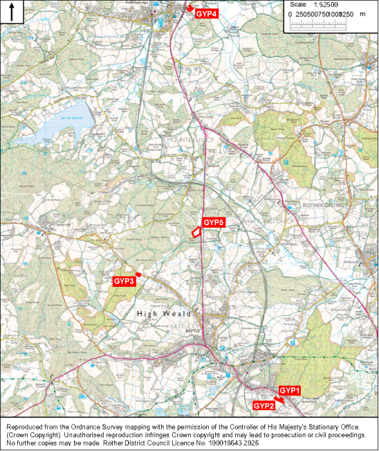
Policy GYP1: Land adjacent to High Views, Loose Farm Lane, Battle Comment
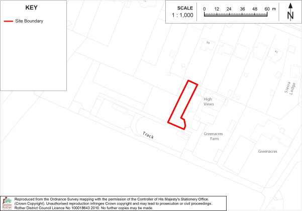
The site is allocated for one permanent pitch for gypsies and travellers.
Development on this site must:
i. Include native planting on the site boundaries, in accordance with a scheme to be approved as part of the planning application.
16.1The site is located on the urban edge of Battle adjacent to an existing gypsy and traveller site which comprises of six pitches. The site forms part of a disused smallholding which itself is an area of despoiled land which adjoins residential dwellings in ribbon development to the north and rolling open countryside to the south. It has previously been granted planning permission for a single pitch, and while this was not implemented, the site remains suitable for the use in principle.
16.2The site is allocated for one permanent pitch for gypsies and travellers.
16.3The site is accessed via a single track off Loose Farm Lane, a narrow lane which connects the small complex of buildings at Loose Farm with the A2100 (Hastings Road). It is within the High Weald National Landscape but it is not prominent when viewed from the adjacent countryside to the south and appears to be well screened by existing fencing, although would benefit from some soft landscaping from further native species screening on the southern and western boundaries. Care should be taken to respect the amenity of adjoining properties on the northern boundary.
16.4The provision of one pitch is considered to be acceptable in terms of access by vehicles, impact on the local environment and the amenity of residential neighbours and in terms of its proximity to services and the relationship and scale with the settled community.
Policy GYP2: Land south of Hastings Road, Battle Comment
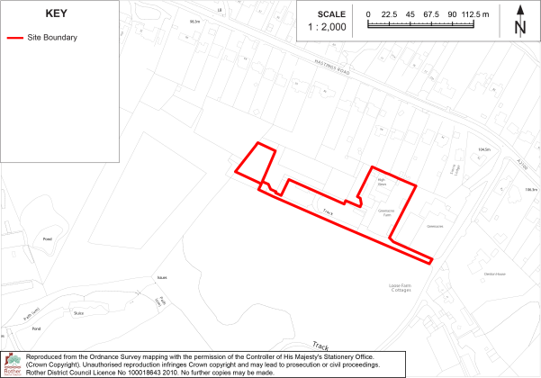
The site is allocated for up to five additional permanent pitches for gypsies and travellers.
Development on this site must:
i. Retain and enhance existing hedgerows and trees on the site boundaries.
16.5The site comprises four adjoining parcels of land which currently have planning permissions for a total of six pitches for gypsies and travellers (which are all occupied), plus an additional adjoining parcel of land to the west, within the same ownership.
16.6The site is allocated for up to five additional permanent pitches for gypsies and travellers.
16.7This would include two pitches on the additional parcel of land, plus an additional three pitches within two of the parcels with planning permission. As such, this represents both an extension to, and intensification of use of, existing permitted gypsy and traveller sites.
16.8The site adjoins site allocation GYP1 (Land adjacent to High Views), on the urban edge of Battle, forming part of a disused smallholding. Residential dwellings in ribbon development lies to the north and rolling open countryside to the south. Like site GYP1, the site is accessed via a single track off Loose Farm Lane, a narrow lane which connects Loose Farm with the A2100 (Hastings Road). It is within the High Weald National Landscape.
16.9The site is well enclosed by boundary trees and hedges, and positioned adjacent to existing development. Consequently, it is not prominent when viewed from the adjacent countryside to the south, and would not represent an intrusion into the rural area. Existing boundary hedgerows should be retained as part of any development and enhanced with additional native planting where possible.
16.10The site is an appropriate location for a small number of additional gypsy and traveller pitches, which can be accommodated without harming the landscape or character of the High Weald or the residential amenity of adjoining occupiers.
Policy GYP3: Land adjacent to Fir Tree Cottage, Netherfield Hill, Battle Comment
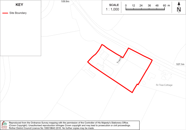
The site is allocated for two permanent pitches for gypsies and travellers.
Development on this site must:
i. Retain visibility splays from the site access onto Netherfield of at least 2.4 metres by 95 metres to the north-west and 2.4 metres by 155 metres to the south-east;
ii. Include provision for the retention and future management of a buffer zone of semi-natural habitat, at least 15 metres wide, on the north-western boundary, between the edge of development and the ancient woodland;
iii. Retain and protect the existing mixed native hedgerows on the south-western and north-western edges of development.
16.11The site is on the southern side of Netherfield Road, midway between Battle (to the south-east) and Netherfield (to the north-west).
16.12 The site is allocated for two permanent pitches for gypsies and travellers.
16.13This policy allocates an existing gypsy and traveller site, comprising two pitches, which currently benefits from a temporary planning permission. It is not ideally located for sustainable travel options but is a short driving distance to facilities in both settlements. The site is within the High Weald National Landscape and adjoins an area of Ancient Woodland and Priority Habitat.
16.14 While the site is screened to an extent from the road and the north by existing woodland, it is open to views from the south and does have some harmful landscape impact due to the caravans and residential paraphernalia being out of keeping with the rural character of the area, a concern that has been raised in planning and appeal decisions at the site.
16.15 However, the site is of a small scale, and additional planting has recently been established on site boundaries, which, over time, will assist in screening the development from the wider countryside. There is a level of development along Netherfield Road, and given the need for gypsy and traveller pitches in the district over the Plan period it is appropriate to retain this existing, currently temporary site through a permanent site allocation.
16.16 The site lies within the Brightling Gypsum Mine/ Robertsbridge Gypsum Works Minerals Consultation Area (MCA) as identified by the East Sussex, South Downs and Brighton & Hove Waste and Minerals Sites Plan (2017) and the Minerals Planning Authority and the mine operator should be consulted.
Policy GYP4: Land south of Redlands Lane, Salehurst Comment
The site is allocated for four permanent pitches for gypsies and travellers.
Development on this site must:
i. Provide for up to four pitches for gypsies and travellers, to be managed and controlled by East Sussex County Council as an extension to the existing adjoining site;
ii. Be accessed from Redlands Lane or via the adjoining Gypsy and Traveller site;
iii. Protect and retain the existing trees on the boundaries of the site.
iv. Be subject to a site-specific flood risk assessment which demonstrates that no built development within the site boundary, including access or escape routes, land raising or other potentially vulnerable elements, would be located on an area that would be at risk of flooding from any source, now and in the future.
v. Include sustainable drainage measures in accordance with Policy ENV2 of the Rother Local Plan.
vi. Be informed by an odour assessment to be undertaken in consultation with statutory wastewater operator for the works.
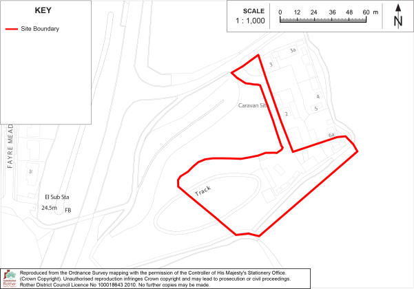
16.17The site is on the southern side of Redlands Lane, just east of the A21 Robertsbridge bypass. It comprises an overgrown area of hard standing, formerly a County Council depot, and adjoins an established gypsy and traveller Site comprising eight pitches to the east.
16.18 The site is allocated for four permanent pitches for gypsies and travellers.
16.19The site is within walking distance of services and facilities in Robertsbridge, although it is on the opposite side of the A21 to the village.
16.20The site offers an opportunity to provide an extension of four pitches to the adjoining Gypsy and Traveller Site, which is managed by East Sussex County Council (ESCC). To ensure appropriate management and cohesion with the adjoining use, the additional pitches would also need to be managed by ESCC.
16.21The site is within the High Weald National Landscape and forms part of a larger plot of land which contains Priority Habitat (deciduous woodland) across its northern and western sections and a small area at risk of surface water flooding in its central section. Boundary trees would need to be retained and protected, and built development would need to avoid the flood risk area, and measures included to ensure sustainable drainage. The site is within 500m of an operational wastewater treatment works and therefore the layout should be informed by an odour assessment to be undertaken in consultation with statutory wastewater operator for the works.
Policy GYP5: Land adjacent to Valentine Ridge, A2100, Mountfield Comment
The site is allocated for up to six additional permanent pitches for gypsies and travellers.
Development on this site must:
i. Utilise the existing vehicular access from the A2100 which serves the existing gypsy and traveller pitches in the northern part of the site;
ii. Include provision for the retention and future management of a buffer zone of semi-natural habitat, at least 15 metres wide (which does not include residential gardens), on the north-western, south-western and south-eastern boundaries, between the edge of development and the ancient woodland;
iii. Be informed by a landscape assessment to determine an appropriate layout and planting scheme to ensure the conservation and enhancement of the landscape and character of the High Weald National Landscape and the protection of biodiversity.
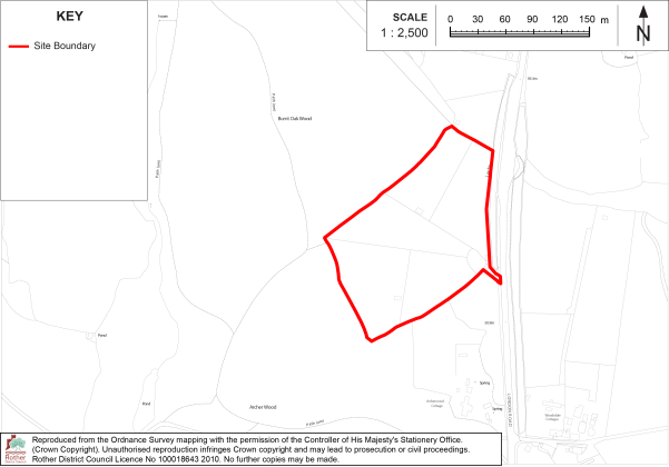
16.22 The site is on the western side of the A2100 London Road some two kilometres north of Battle and one kilometre south of Mountfield Village. It comprises a field surrounded by ancient woodland on three boundaries, with mature hedging and trees on the remaining (roadside) boundary.
16.23The site is allocated for up to six additional permanent pitches for gypsies and travellers.
16.24The northern half of the field benefits from permanent planning permission for four pitches for gypsies and travellers. As such, the allocation represents an extension to an existing permitted gypsy and traveller site.
16.25The site is not ideally located for sustainable travel options but is a short driving distance to services and facilities in Battle. The site is within the High Weald National Landscape but is not in an area of the highest landscape value or sensitivity due to its proximity to the busy A2100 and scattered development alongside the road. The site is very well screened in the local landscape by the adjoining trees and woodland and could accommodate a small number of additional gypsy and traveller pitches without harming the landscape and character of the area, subject to an appropriate layout, and separation from the adjoining ancient woodland.
16.26 The site also lies within the Mineral Safeguarding Area (MSA) for the Brightling Gypsum Mine as identified by the East Sussex, South Downs and Brighton & Hove Waste and Minerals Sites Plan (2017) and the Minerals Planning Authority and the mine operator should be consulted.
