
Rother Local Plan 2025-2042 Regulation 19 (pre-submission) version September 2026
Chapter 12: Battle and Surrounding Settlements Sub-Area: Vision, Strategy and Site Allocations
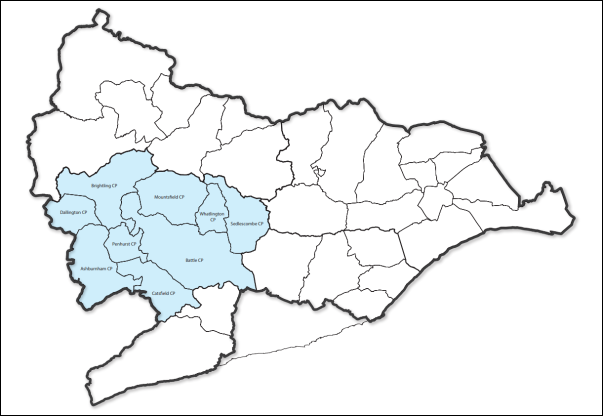
Includes the parishes of Ashburnham, Battle, Brightling, Catsfield, Dallington, Mountfield, Sedlescombe and Whatlington
Vision for Battle and Surrounding Settlements Comment
Battle will retain its historical character at its core and preserve its local distinctiveness and important setting within the High Weald National Landscape. Employment opportunities will be enhanced through sensitive commercial development, including through extensions to and densification of existing employment sites. Opportunities for brownfield residential development within the urban areas of Battle will be realised with higher densities achieved in sustainable locations.
A greater amount of sensitive growth will take place south-west of Hastings Road with linked opportunities for habitat creation, restoration, enhancement and community access.
Sensitive development will be delivered in villages surrounding Battle, at densities consistent with the surrounding area, where it is sustainable and does not negatively impact the setting of the High Weald NL. A reasonable level of growth will help support improving the overall sustainability and vitality of the cluster of villages around Battle, through supporting existing services and facilities as well as delivering developer contributions for wider community benefit. This will ensure that health and wellbeing and community cohesion is maintained and improved.
800 dwellings and 12,971 sqm of employment floorspace is allocated across the Battle and Surrounding Settlements sub-area.
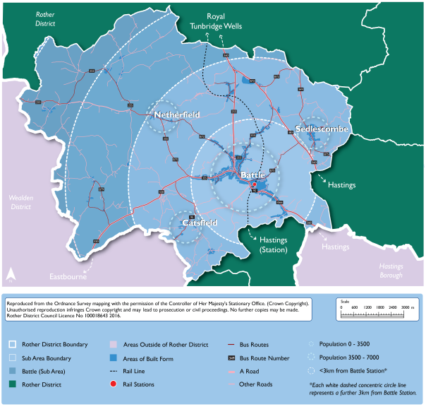
12.1The Battle and Surrounding Settlement sub-area contains the parishes of Ashburnham, Brightling, Battle, Catsfield, Dallington, Mountfield, Sedlescombe and Whatlington and all the settlements within them.
12.2Allocated sites within the parishes of Battle, Brightling, Catsfield, Netherfield and Sedlescombe contain residential and employment development.
12.3 The sustainability scores of the settlements containing allocated sites, as defined in the Settlement Study, range from good to poor. The amount of development allocated generally reflects these sustainability ratings, with more sustainable settlements receiving a greater share of growth within the sub-area.
12.4Battle is a relatively small, historic market town which provides an important local centre for its residents and those of surrounding villages, affording it a town centre designation. In addition, Battle is a popular tourist destination for domestic and foreign visitors. The town has a train station, which will benefit from step free access in the future to improve its accessibility, but can suffer from congestion on its roads, particularly in the peak summer tourist season, as traffic is channelled along narrow roads through the historic town centre.
12.5The whole town of Battle and the immediate surrounding countryside is within the High Weald National Landscape (NL) with large areas of woodland having Ancient Woodland and Priority Habitat designations. The town centre, the historic Battle Abbey and the designated battlefield form the historic core, which was first designated as a Conservation Area in 1971. Battle has historically developed in a linear fashion along one of the principal High Weald east-west ridges, which has led to areas of the town and surrounding area being visually exposed in the landscape. Due to the combination of its landscape and heritage constraints, and accessibility limitations, growth is constrained. However, there is a need to support the town’s role and economic vitality, through sensitive residential (including affordable housing) and commercial developments to increase opportunities for housing and employment locally.
12.6The village of Netherfield is also within Battle parish, with the villages of Catsfield and Sedlescombe nearby. All are likely to depend on the larger town for access to a wider range of key services and facilities. A sensitive amount of residential and commercial development is allocated in these settlements.
12.7 Catsfield is a historic settlement located in the west of the district approximately 3 miles to the west of Battle. The village has developed around a church located in a present-day triangular road layout which provides the nucleus of the settlement, comprising Church Lane, The Green and Church Road, with further residential development branching off along Skinners Lane. The settlement contains pockets of wooded areas with Ancient Woodland and Priority Habitat designations, with the lower lying areas being at risk of surface water flooding. The settlement is relatively well-contained within the HWNL, with Church Road comprising the boundary to the HWNL. Catsfield has a good range of services including a village hall, primary school and convenience store, however its overall sustainability is constrained by a lack of employment opportunities. The allocated sites are considered to have potential for small to medium scale development which will facilitate better public transport accessibility and active travel accessibility through the settlement to the primary school.
12.8Netherfield is located in the western part of the district approximately 3.5 miles north-west of Battle and has developed in a sporadic, linear fashion along Battle and Netherfield Road, latterly with the Darvel Down estate and primary school creating a more focussed settlement centre. Netherfield occupies an elevated, ridge top position overlooking historic fieldscapes and woodland within the sub-area, leading to it being highly visible within long distance vistas from the south of the settlement. The settlement has a good range of key services including the primary school, a village hall, playing pitch and convenience store. However, its overall sustainability is constrained by a lack of public transport provision.
12.9Sedlescombe village is located in the centre of the parish approximately 3.5 miles east of Battle and the same distance north of Hastings. The settlement developed from the village green spreading along The Street with estates branching off Brede Lane, with pockets of wooded areas in the settlement having Ancient Woodland and Priority Habitat designations. Some areas of the settlement are particularly visible within long distance vistas from the west. Sedlescombe has a good range of services including playing pitches, a village hall and a primary school, but its relative sustainability is somewhat constrained by the level of services and public transport accessibility.
12.10 No sites have been allocated within the parishes of Ashburnham, Dallington, Mountfield, or Whatlington. This is largely due to the settlements within these parishes being particularly constrained in landscape terms, often exposed to long views within the High Weald National Landscape, and also their relatively remoteness, having a poor range and level of services.
12.11 The table below sets out the quantum of development allocated in Battle and the surrounding settlements in terms of the numbers of dwellings and the amount of employment floorspace to be delivered over the Plan period. These figures have been derived from the total amount of development allocated through the site allocations, detailed later in this document.
Figure 12.2: Battle and Surrounding Settlements Quantum of Development
|
Settlement Area |
Total housing (dwelling nos) |
Total employment floorspace (sqm) |
|
Battle |
565 |
4595 |
|
Sedlescombe |
116 |
6515 |
|
Catsfield |
85 |
0 |
|
Netherfield |
34 |
0 |
|
Brightling (Parish) |
0 |
1861 |
|
Total Growth |
800 |
12,971 |
Sustainability Coding for Settlements (Source: Rother Settlement Study, 2024)
|
Highly sustainable |
Very Good sustainability |
Good sustainability |
Fair sustainability |
Poor sustainability |
Very Poor sustainability |
Battle
Parish: Battle
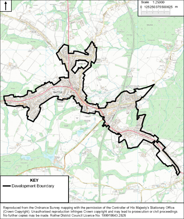
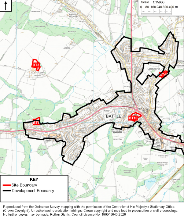
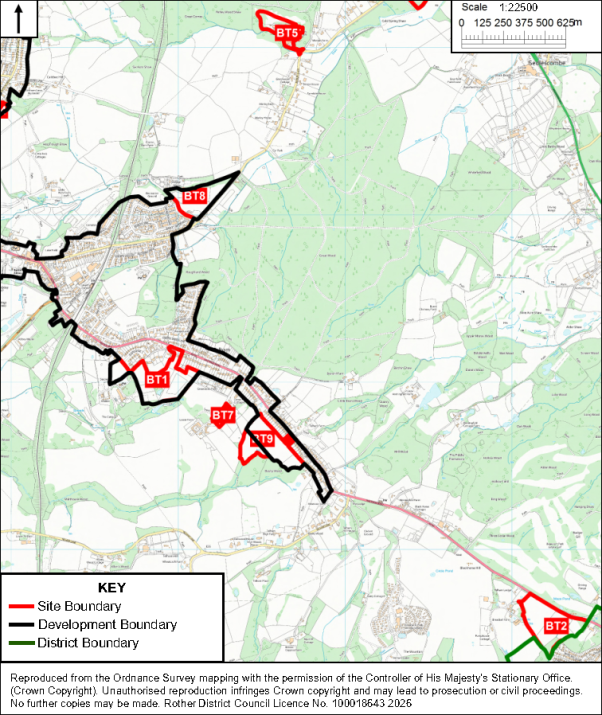
Policy BT1: Land south of Hastings Road, Battle. Comment
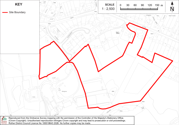
The site is allocated for residential development comprising 200 dwellings.
Development on this site must:
- Provide a policy-compliant amount of on-site affordable housing in line with policy HOU2 of the Rother Local Plan;
- Comply with a whole-site masterplan, to be developed by the site promoter, to identify uses and areas for development, areas for green infrastructure, and vehicular, pedestrian and cycle links. The masterplan should be informed by a landscape and visual impact assessment to determine an appropriate layout, form and detailed design to ensure the conservation and enhancement of the landscape and character of the High Weald National Landscape and the protection of the setting of heritage assets.
- Allow for a comprehensive scheme to be developed across the whole site in the event the parcels of land come forward separately in accordance with Policy DEV2 of the Rother Local Plan;
- Include new vehicular access(es) from Hastings Road and Glengorse;
- Include new pedestrian and cycle links to Hastings Road and Glengorse;
- Include areas of green infrastructure and public open space in line with the ratios indicated in the supporting text;
- Provide accessible pedestrian and cycle links permeating the extent of the site from each access on Glengorse and Hastings Road;
- Provide community uses to include a building for community use, as required;
- Establish a strong landscape buffer to the southern and eastern edges of the site;
- Ensure the setting of Glengorse Estate is protected;
- Include provision for the retention and future management of a buffer zone of semi-natural habitat, at least 15 metres wide (which does not include residential gardens), on the southern boundary, between the edge of development and the Ancient Woodland;
- Retain and protect the existing pond in the south-eastern part of the site and provide an appropriate buffer to any built development including roadways.
12.12This is a large site on the southern fringe of the town of Battle comprising a number of separate land parcels consisting of fields, paddocks and a residential curtilage. It gradually slopes away south from existing built development located adjacent to Hastings Road and Glengorse to the north. The site is located within the High Weald National Landscape; therefore, a sensitive form of development is required in line with Local Plan policies.
12.13The site is within the Historic Towns Area Type, has a site size of 7.6 hectares and an indicative developable area of 5 hectares. It is allocated for some 200 dwellings at an indicative residential density of 40 dwellings per hectare. A small part of the allocation (some 20 dwellings) is carried forward from the Battle Neighbourhood Development Plan.
12.14Environmental and other constraints affecting the site include Priority Habitats, Ancient Woodland and surface water flooding risk to the southern boundaries of the site, and a wildflower meadow contained in the western most field. The policy requirements detailed above reflect these. The western field is within, and the southern boundary borders, Areas that Could become of Importance for Biodiversity as defined by the East Sussex Local Nature Recover Strategy (ESLNRS). Any proposed scheme will therefore be required to take opportunities to provide Biodiversity Net Gain which contributes to the measures and objectives of the ESLNRS. The Glengorse Estate, located to the west of the main body of the allocation, is a non-designated heritage asset within the Battle Neighbourhood Plan, therefore its setting must be protected.
12.15The site is located within the High Weald National Landscape (HWNL) and occupies a sensitive edge-of-settlement location, where development would be experienced both as part of the eastern approach to Battle and as an extension of built form onto land sloping southwards from Hastings Road and Glengorse. It is therefore important that the transition from countryside to town is re-enforced and does not diminish the sense of arrival into Battle from the east. The design response should therefore avoid a hard or generic urban edge to Hastings Road and should instead reinforce a legible, landscape-led threshold into the settlement, with retained hedgerows, trees, green verges, appropriate setbacks, and built form arranged to respond to topography and existing landscape structure. A varied density strategy is considered appropriate, with lower density and stronger landscape structure at the southern, eastern and western interfaces, and any greater density focused only where it can be accommodated without harm to landscape character, heritage setting or the approach to Battle.
12.16While the allocation is likely to be considered major development in the HWNL, it is justified in this location due to its proximity to facilities and services within Battle and having regard to the need to provide housing. Overall, the policy requirements and the mitigation measures required will ensure the development conserves and enhances the natural beauty of the HWNL.
12.17Subject to a sensitive design that addresses the constraints, the site is considered suitable for a larger-scale residential development comprising some 220 dwellings and community uses (as appropriate) together with large areas of green infrastructure, to include public open space and the retention and protection of Priority Habitat. It is anticipated that the open space will be located around the pond in the south-eastern part of the site. The land adjoining the site to the west is a wildflower meadow and should be retained as an undeveloped parcel, potentially to be used for further habitat creation.
12.18Vehicular, pedestrian and cycle access to the site should be via Glengorse and Hastings Road. The entrance at Hastings Road is likely to require some further work, potentially including tree clearing, to ensure a suitable gradient and widening of the access to make it suitable for a vehicular access to serve the level of development set out in the policy.
12.19The sustainability of the site, in terms of its proximity to services and facilities in Battle, graduates from north-west to south-east with the western areas being closer to services and amenities and the eastern areas being less sustainably located. As such, pedestrian and cycle infrastructure must be designed to encourage active travel to the main access points to the site, as detailed through the policy requirements above, in addition to strong linkages to existing bus stops and potentially provision of new stops in consultation with the local Highway Authority. The site is some distance from primary schools in Battle and Crowhurst and mitigation, for example through improved transport links or financial contributions towards off-site infrastructure improvements, will be required at planning permission stage. The size of the site does however lend itself to the inclusion of community uses which could potentially include provision of a community building to be used by an early-years nursery, should this be required.
Policy BT2: Land at Breadsell, Battle. Comment
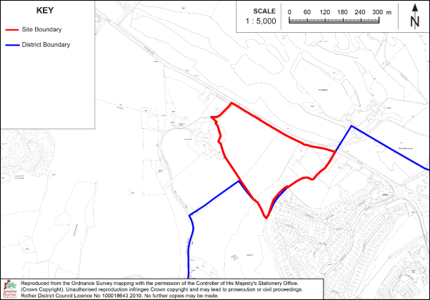
The site is allocated for residential development comprising some 145 dwellings.
Development on this site must:
- Form part of a comprehensive scheme to be developed in conjunction with the adjoining, larger, plot of land to the south within Hastings borough.
- Provide a policy-compliant amount of on-site affordable housing in line with policy HOU2 of the Rother Local Plan.
- Be informed by a landscape and visual impact assessment to determine an appropriate layout, form and detailed design to ensure the conservation of the setting of the adjacent High Weald National Landscape.
- Include a new vehicular access from Hastings Road A2100 to the satisfaction of the Highway Authority.
- Include new pedestrian and cycle links to Hastings Road A2100 and to adjoining land within Hastings borough to the south-west.
- Include any off-site highway improvements necessary to make the development acceptable, in accordance with the requirements of the Highway Authority, including improvements to pedestrian, cycle and bus infrastructure.
- Include provision for the retention and future management of a buffer zone of semi-natural habitat, at least 15 metres wide (which does not include residential gardens), on the southern boundary, between the edge of development and the Ancient Woodland.
- Retain and enhance the existing hedgerow/ trees on the south-eastern boundary of the site.
- Be informed by agreed land stability and geotechnical reports.
12.20This site comprises the northern sections of wide, open fields on high ground to the south of the A2100, adjacent to the Hastings Borough boundary. The site forms part of a larger area of land, comprising five fields extending south into Hastings, which has been considered by both Local Authorities in the past for a potential strategic, cross-boundary, mixed-use development, the larger part of which would be in Hastings. The part of the site that lies within Rother comprises two sections of two large fields.
12.21The site is within the Live Well Locally Area Type, has a site size of 6.95 hectares and an indicative developable area of 4.17 hectares. It is allocated for some 145 dwellings at an indicative residential density of 35 dwellings per hectare.
12.22Environmental and other constraints affecting the site include Ancient Woodland and Priority Habitat adjacent to the southern boundary, the High Weald National Landscape adjacent to the west, Local Wildlife Site Beauport Park on the opposite side of the road to the site and surface water flooding to the southern boundary. In addition, the Marline Valley Woods Site of Special Scientific Interest (SSSI) is located adjacent to the south-western boundary and runs along the eastern edge of the wider site within Hastings Borough.
12.23A scoping level hydrological and hydrogeological assessment of a proposed housing development on this site was carried out in 2009 by specialists, Rigare, to investigate the potential effects on the Marline Valley Woods SSSI. This indicated that a development would likely lead to impacts on the SSSI, and set out that significant work, including a lengthy period of ecohydrological monitoring, is required to understand impacts. Consequently, following advice from Natural England, the site was not included in the adopted Hastings Local Plan although the Rother Core Strategy (adopted 2014) does make provision for a sustainable scheme to come forward in the longer term at the site, if the environmental, access to services and transport constraints were satisfactorily addressed.
12.24 The site promoter of the section within Hastings borough has now been in contact with Hastings Borough Council, Rother District Council and Natural England to seek to agree a programme of monitoring that would be sufficient to determine the impact upon the SSSI. Once this programme has been agreed, monitoring of the site will be carried out by the site promoter to determine the impacts of development upon the SSSI and any mitigation measures that could make development acceptable. If the constraints can be satisfactorily addressed, the land within Rother is considered suitable to form part of a strategic scale, cross-boundary, residential-led development.
12.25The land within Rother is not ideally suited for development without the adjoining land within Hastings due to it being too small for a strategic development and being in a relatively unsustainable location. It is also in a sensitive landscape adjacent to the High Weald National Landscape and within the Strategic Gap between Crowhurst, Battle and Hastings, allocated in order to maintain the separate identities of the settlements. In the event of a strategic scale residential-led development coming forward across the wider site, the benefits of the significant level of additional housing are likely to outweigh the impact on the Strategic Gap. In landscape terms, a larger scale development, as indicated, would result in, in effect, a logical extension to the built form of Hastings rather than an isolated pocket of development encroaching into the countryside.
12.26The vehicular access to the wider site would come from the A2100 Hastings Road, within Rother. Initial Highway Authority comments identify that transport assessment and road safety assessment work would be required to determine impacts on the road network. The A2100 only has a footway on one side and derestricted speeds at this point, factors which are not conducive to encouraging active travel. Improvements to bus infrastructure and means of access to bus stops would be required, together with pedestrian links to adjoining land in Hastings to the south-west.
Policy BT3: Beech Farm, Battle. Comment
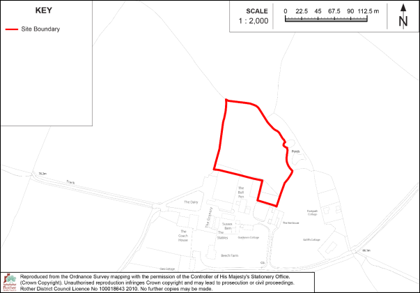
The site is allocated for employment development comprising some 1895sqm of new employment floorspace (use class E(g), B2 or B8).
Development on this site must:
- Include a new vehicular access from North Trade Road;
- Provide links to the public right of way that runs adjacent to the southern boundary of the site;
- Retain and enhance the existing hedgerow/ trees on the north, west and east boundaries of the site all of which are historic field boundaries.
12.27The site comprises a relatively well-contained undeveloped area to the north of the Beech Estate industrial park in the countryside near Battle, suitable for small scale employment development. It previously had a planning permission granted for this form of development, although this is understood to have now expired.
12.28The site is within the Countryside Area Type, has a site size of 0.91 hectares and an indicative developable area of 0.2 hectares.
12.29It is within the High Weald National Landscape and therefore a sensitive form of development is required in line with Local Plan policies.
12.30Environmental and other constraints affecting the site include historic field boundaries to the north, west and east boundaries including a public right of way running adjacent to the southern boundary, with the policy requirements detailed above to reflect these.
12.31 The site is not within walking distance of town services; however, it adjoins an established business park and is appropriately located for these uses. National planning policy supports the sustainable growth and expansion of all types of business in rural areas, recognising that sites in rural areas may have to be found beyond existing settlements. The allocation provides flexibility in terms of the specific use class of the employment use. The appropriate use class would be for determination at planning application stage, having regard to the nature of the particular proposal and the site constraints.
Policy BT4: Land at Caldbec House, Battle. Comment
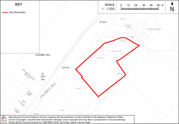
The site is allocated for residential development comprising 5 dwellings.
Development on this site must:
- Include a new vehicular access from Caldbec Hill
- Include new pedestrian and cycle links to Caldbec Hill
- Retain and enhance the boundary planting to the south-east of the site
12.32The site comprises an existing dwelling and large wrap-around garden space in the town of Battle and within the High Weald National Landscape. The site is well located in relation to services and facilities in Battle.
12.33The site is within the Historic Towns Area Type, has a site size of 0.47 hectares and an indicative developable area of 0.15 hectares. It is allocated for some 5 dwellings at an indicative residential density of 40 dwellings per hectare. The allocation is carried forward from the Battle Neighbourhood Development Plan.
12.34Having regard to existing residential development on Caldbec Hill, it is considered that small scale residential development can be accepted across parts of the site, subject to a sensitive design.
12.35Environmental and other constraints affecting the site include an adjacent historic field boundary to the south-east of the site and the policy requirements detailed above reflect these.
Policy BT5: Rutherfords Business Park, Battle. Comment
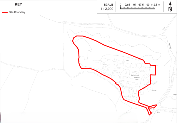
The site is allocated for employment development comprising some 2700sqm of new employment floorspace (use class E(g), B2 or B8).
Development on this site must:
- Improve where appropriate the existing vehicular access from Marley Lane.
- Retain the existing hedgerow/ trees on the west, east and south boundaries of the site.
- Include provision for the retention and future management of a buffer zone of semi-natural habitat, at least 15 metres wide on the western boundary, between the edge of development and the Ancient Woodland.
12.36The site comprises the existing, but currently vacant, Rutherfords Business Park and an adjoining field to the north, on the fringes of Battle and within the High Weald National Landscape.
12.37The site is within the Countryside Area Type, has a site size of 2.78 hectares and an indicative developable area of 1.39 hectares.
12.38Having regard to the existing development on site, it is considered that a medium scale intensification of the business park is acceptable, subject to a sensitive design and compliance with the policy requirements.
12.39Environmental and other constraints affecting the site include a Historic Fieldscape Assart within the north section, Historic Field Boundary to the south, Priority Habitat encroaching the east boundary, Ancient Woodland and Priority Habitat adjacent to the west boundary and surface water flood risk nearby to the south boundary.
12.40The site is relatively remote in relation to services; however, it includes an established business park (currently vacant) and is appropriately located for business uses. National planning policy supports the sustainable growth and expansion of all types of business in rural areas, recognising that sites in rural areas may have to be found beyond existing settlements. The allocation provides flexibility in terms of the specific use class of the employment use. The appropriate use class would be for determination at planning application stage, having regard to the nature of the particular proposal and the site constraints
Policy BT6: Land north of Sunny Rise, Battle. Comment
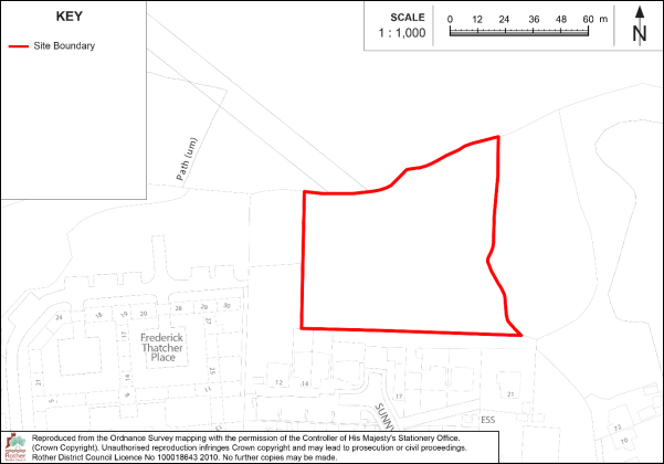
The site is allocated for residential development comprising 10 dwellings.
Development on this site must:
- Provide a policy-compliant amount of on-site affordable housing in line with policy HOU2 of the Rother Local Plan;
- Include a new access via Sunny Rise, suitable for vehicles and active travel users;
- Include no built development in the northern part of the site which is shown to be at risk of surface water flooding;
- Include provision for the retention and future management of a buffer zone of semi-natural habitat, at least 15 metres wide (which does not include residential gardens), on the northern and eastern boundaries, between the edge of development and the Ancient Woodland; retain the existing hedgerow and trees on the north, east and west boundaries of the site;
- Protect the setting of the Grade II listed building (Beacon Cottage).
12.41This site comprises a well-contained field located to the north of existing residential development at Sunny Rise and is considered suitable for small-scale residential development. It is within the High Weald National Landscape and therefore a sensitive form of development is required in line with Local Plan policies.
12.42The site is within the Historic Towns Area Type, has a site size of 0.58 hectares and an indicative developable area of 0.35 hectares. It is allocated for some 10 dwellings at an indicative residential density of 35 dwellings per hectare.
12.43Environmental and other constraints affecting the site include Ancient Woodland and Deciduous Woodland Priority Habitat located adjacent to the site, with part of the site at risk from surface water flooding, and a Grade II listed building nearby the access to the site, with the policy requirements detailed above reflecting these. The adjacent areas of woodland and habitat are also Areas of Potential Importance for Biodiversity as defined by the East Sussex Local Nature Recover Strategy (ESLNRS). Any proposed scheme will therefore be required to take opportunities to provide Biodiversity Net Gain which contributes to the measures and objectives of the ESLNRS.
12.44The site is well located in relation to amenities and services located in Battle. Vehicular access will be required to come via Sunny Rise, as an alternative access route from the south-east is likely to be unacceptable due to impacts on residential amenity, established woodland and highway safety.
Policy BT7: Land adjacent to 1 Loose Farm Cottages, Battle. Comment
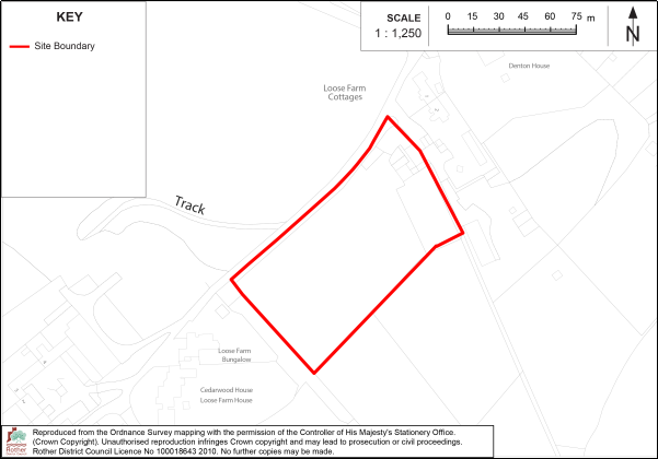
The site is allocated for residential development comprising 5 dwellings.
Development on this site must:
- Include a new vehicular access from Hastings Road.
- Include new pedestrian and cycle links to Hastings Road.
- Establish a strong boundary hedge to form a visual buffer to the southern and western edges of the site.
12.46The site comprises the northern section of a gently sloping field, to the south of ribbon development along Hastings Road and close to scattered development along the adjacent private lane, including cottages to the north and a residential care home and historic farmstead to the south, on the southern edge of Battle and within the High Weald National Landscape.
12.47The site is within the Historic Towns Area Type, has a site size of 0.17 hectares and an indicative developable area of 0.11 hectares. It is allocated for some 5 dwellings at an indicative residential density of 35 dwellings per hectare.
12.48Having regard to existing residential development on Hastings Road, it is considered that a small-scale residential development can be accepted subject to a sensitive design.
12.49 The site is located some distance from Battle town centre, however there is a bus service operating along Hastings Road nearby.
Policy BT8: Land east of Coronation Gardens, Battle. Comment
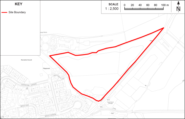
The site is allocated for residential development comprising 75 dwellings.
Development on this site must:
- Provide a policy-compliant amount of on-site affordable housing in line with policy HOU2 of the Rother Local Plan;
- Be informed by a landscape and visual impact assessment to determine an appropriate layout, form and detailed design to ensure the conservation and enhancement of the landscape and character of the High Weald National Landscape;
- Include a new vehicular access from Marley Lane;
- Include new pedestrian and cycle links through to Coronation Gardens, or if possible, attaching to the existing nearest pedestrian footpath alongside Marley Lane, opposite Harrier Lane;
- Retain the established hedgerows and trees to all boundaries of the site, barring removal of those required for safe access to the site in line with local Highway Authority standards;
- Leave a minimum safe distance to the sewerage works located to the north-west of the site, as advised by the sewerage undertaker;
- The layout of development should be informed by an odour assessment to be undertaken in consultation with statutory wastewater operator for the works.
12.50The site comprises a well-contained set of three fields adjacent to existing built development on the edge of Battle, considered suitable for medium scale residential development.
12.51The site is within the Historic Towns Area Type, has a site size of 4.58 hectares and an indicative developable area of 2.29 hectares. It is allocated for some 75 dwellings at an indicative residential density of 35 dwellings per hectare.
12.52Environmental and other constraints affecting the site include an area of surface water flooding to the northern boundary located adjacent to a sewerage works and historic field boundary.
12.53The site is located within the High Weald National Landscape (HWNL) and occupies an edge-of-settlement location which is well enclosed by strong boundary tree and hedgerows. The primary HWNL characteristics present here are the historic boundary hedgerows and glimpsed views from the west of the site towards the north-east. The design response should therefore retain hedgerows and trees to the site boundaries, whilst also taking the opportunity to replace the Leyland cypress to the southern boundary with a hazel hedgerow, whilst establishing a tree belt of dispersed oak and field maples to the south-eastern boundary within the hazel hedgerow. The built form should be arranged to respond to the topography and existing landscape structure with a varied density strategy, which will ensure appropriate vistas are maintained and buffers are secured to the hedgerows. It is anticipated that any greater density is focused only where it can be accommodated without harm to landscape character and hedgerows. Overall, the policy requirements and the mitigation measures required will ensure the development conserves and enhances the natural beauty of the HWNL.
12.54The site is relatively well located in relation to amenities and services available in Battle and to Battle railway station. However, currently there is a lack of pedestrian connectivity due to no footway along this stretch of Marley Lane, and this must be remedied as part of the development in order to make it acceptable. This could either be via a pedestrian link through to Coronation Gardens, or if possible, attaching to the existing nearest pedestrian footpath alongside Marley Lane, opposite Harrier Lane, subject to the requirements of the Highway Authority. Cycle connections will also be required.
Policy BT9: Land adjoining Little Brans, Battle. Comment
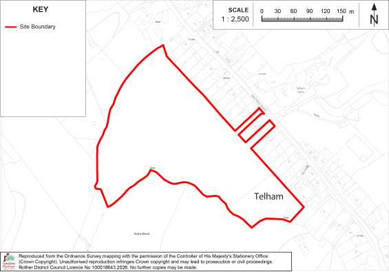
The site is allocated for residential development comprising 73 dwellings
Development on this site must:
- Provide a policy-compliant amount of on-site affordable housing in line with policy HOU2 of the Rother Local Plan
- Include a new vehicular access from Hastings Road.
- Include new pedestrian and cycle links to Hastings Road.
- Include off-site pedestrian infrastructure as required by the Highway Authority (which could include new pedestrian footways and/ or a crossing point on Hastings Road).
- Retain the established hedgerows and trees to all boundaries of the site.
- Retain a suitable undeveloped buffer area to the designated Priority Habitat adjacent to the southern boundary of the site.
- Include provision for the retention and future management of a buffer zone of semi-natural habitat, at least 15 metres wide (which does not include residential gardens), on the southern boundary, between the edge of development and the Ancient Woodland.
12.55The site comprises a well-contained field at the rear of existing built development fronting Hastings Road, on the southern edge of Battle.
12.56The site is within the Historic Towns Area Type, has a site size of 6.24 hectares and an indicative developable area of 2.45 hectares. It is allocated for some 73 dwellings at an indicative residential density of 30 dwellings per hectare.
12.57Environmental and other constraints affecting the site include an area of designated Ancient Woodland and Priority Habitat adjacent to the south-west boundary and areas at risk of surface water flooding to the western half of the site. The area defined as habitat and woodland is also an Area of Potential Importance for Biodiversity as defined by the East Sussex Local Nature Recover Strategy (ESLNRS). Any proposed scheme will therefore be required to take opportunities to provide Biodiversity Net Gain which contributes to the measures and objectives of the ESLNRS.
12.58 The site is located within the High Weald National Landscape (HWNL) and occupies an edge-of-settlement location which is well enclosed by strong boundary tree and hedgerows. The primary HWNL characteristics present here are the areas of Ancient Woodland adjoining the historic boundary hedgerows and the falling landform to the south-west of the site. The design response should therefore retain the falling landform, hedgerows and trees to the site boundaries whilst also providing appropriate buffers comprised of semi-natural habitat. The built form should be contained to the eastern half of the site, and be arranged to respond to the topography, existing landscape structure and surface water flood risk with a varied density strategy. It is anticipated that any greater density is focused only where it can be accommodated without harm to landscape character and hedgerows. Overall, the policy requirements and the mitigation measures required will ensure the development conserves and enhances the natural beauty of the HWNL.
12.59The site is located some distance to amenities and services available in Battle and Battle Train Station. However, there is a bus stop located in close proximity to the entrance of the site, and subject to pedestrian and cycle links being provided as detailed above together with necessary improvements to pedestrian infrastructure, it is considered acceptable in sustainability terms.
Policy BT10: Battle Market Square, Battle. Comment
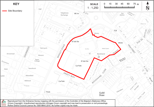
The site is allocated for a mixed-use development comprising:
- Retention of the existing amount of retail floorspace.
- Some 52 dwellings
Development on this site must:
- Provide a policy-compliant amount of on-site affordable housing in line with policy HOU2 of the Rother Local Plan.
- Comply with a whole-site masterplan, to be developed by the site promoter, to identify uses and areas for development, areas for green infrastructure, and vehicular, pedestrian and cycle links. The masterplan should be informed by a character assessment to determine an appropriate layout, form and detailed design to ensure the conservation and enhancement of the character of the High Weald National Landscape and the protection of the setting of heritage assets including Battle Conservation Area.
- Include a vehicular access from Market Road.
- Include new and improved pedestrian and cycle links to Market Road and the High Street.
- Include links to the public footpath that runs along the southern boundary of the site.
- Ensure an active frontage is provided along Market Road.
- Ensure that it does not unreasonably harm the amenities of nearby residential development in terms of loss of light, massing or overlooking.
- Retain and enhance the existing Market Square space in the eastern part of the site.
- Retain public car parking.
- Retain the hedgerow and trees to the south boundary of the site.
- Protect the setting of the of the Grade II listed building (The Almonry) nearby to the east boundary of the site.
- Be planned to ensure future access to existing sewerage infrastructure for maintenance and upsizing purposes.
12.60The site occupies a large corner plot at the northern end of Battle High Street, within the designated Town Centre. It includes a large building, set down and back from Market Road, occupied by retail uses (including a supermarket) with a large public car and coach park to the south, and a market square area to the east. It is considered that re-development of the site to include additional residential and retail uses will enhance its appearance and use, subject to a sensitive design.
12.61The site is within the Historic Towns Area Type, has a site size of 0.9 hectares and an indicative developable area of 0.45 hectares. It is allocated for some 52 dwellings at an indicative residential density of 115 dwellings per hectare.
12.62The policy anticipates a relatively high dwelling per hectare figure. To accommodate this density, the dwellings would need to comprise apartments, with retail on the ground floor of the buildings. Public car parking provision and a market square space would need to be retained, with additional green infrastructure provided, in line with a whole-site masterplan. Within the Rother and Hastings HEDNA (2024) it is shown that there is a need for specialist housing for older people in Rother district over the Plan period. Battle is identified as one of the most sustainable settlements in the district, and given the site’s location, housing for older people could be suitable.
12.63Environmental and other constraints affecting the site include areas to the east and west boundaries being at risk of surface water flooding, the east of the site being within an archaeological notification area and within, and adjacent to, the Battle Conservation Area. In addition, there are several listed buildings nearby to the east, including The Almonry, and the Battle of Hastings Registered Battlefield nearby to the south boundary alongside a public footpath. Additionally, the site is located adjacent to residential development on Market Road, Abbey Way and Woodhams Close.
12.64The site is in close proximity to, and contains, a very good range and level of amenities and services. Improvements to pedestrian and cycle links through the site will further enhance the accessibility of the site within the wider High Street.
Brightling
Parish: Brightling
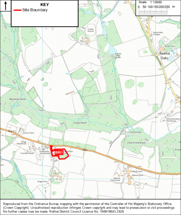
Policy BRI1: Coldharbour Farm Estate, Brightling. Comment
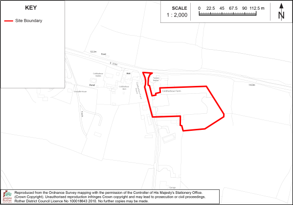
The site is allocated for employment development comprising 1861sqm of new employment floorspace (use class E(g), B2 or B8).
Development on this site must:
- Include a new vehicular access from Battle Road (B2096).
- Retain the existing tree line which runs through the site.
- Protect the setting of the two Grade II listed buildings (Coldharbour Farmhouse and Coldharbour Barn) to the west of the site.
12.66The site is located on the southern side of Battle Road (B2096), outside of any settlement and within the High Weald National Landscape. It is currently occupied by redundant agricultural buildings and a car parking area for an adjacent business.
12.67The site is within the Countryside Area Type, has a site size of 0.97 hectares and an indicative developable area of 0.18 hectares.
12.68Planning permission was granted in 2018 for two new business units on the site which have not yet been constructed. Having regard to the existing employment development on site and adjacent to the site, it is considered that the previously permitted development remains acceptable in principle. Nevertheless, the allocation provides flexibility in terms of the specific use class of the employment use. The appropriate use class would be for determination at planning application stage, having regard to the nature of the particular proposal and the site constraints (meaning a new planning permission may be necessary in any event). Development would need to be limited to the western part of the site to limit the effect on the landscape and nearby listed building, as reflected in the planning permission.
12.69Environmental and other constraints affecting the site include being located partly within a Minerals Safeguarding Area. Further, because the site is within the Pevensey Levels Hydrological Catchment Area, mitigation measures to protect against significant effects to the Pevensey Levels SAC/ Ramsar Habitats Site may be required. There are also two Grade II listed buildings (Coldharbour Farmhouse and Barn) nearby to the west boundary of the site with the policy requirements detailed above to reflect these, and the requirement of the planning permission.
12.70The site is not within walking distance of services; however, it is appropriately located for the industrial uses on site. National planning policy supports the sustainable growth and expansion of all types of business in rural areas, recognising that sites in rural areas may have to be found beyond existing settlements.
Catsfield
Parish: Catsfield
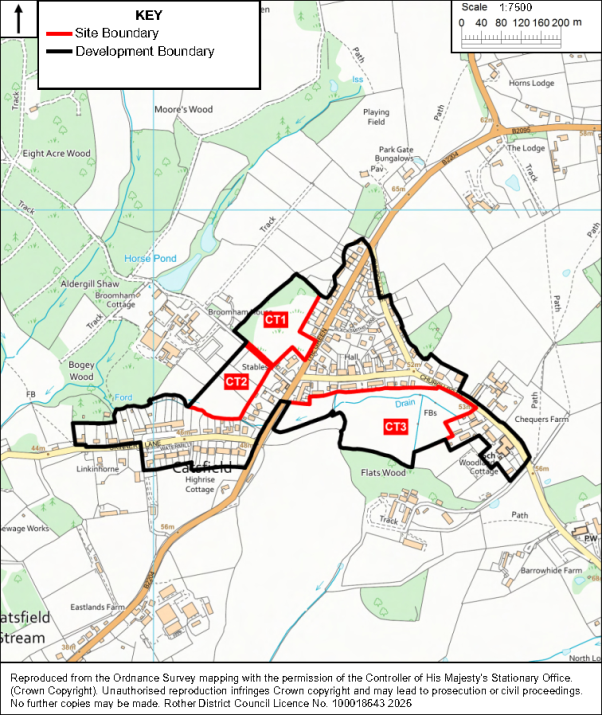
Policy CT1: Land West of B2204, Catsfield. Comment
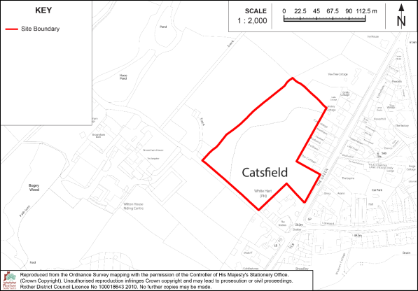
The site is allocated for residential development comprising 30 dwellings.
Development on this site must:
- Provide a policy-compliant amount of on-site affordable housing in line with policy HOU2 of the Rother Local Plan
- Include a new vehicular access from the B2204.
- Include a pedestrian link to the 1066 Country Walk.
- Include an area of amenity open space across the road frontage.
- Retain and enhance the existing hedgerow/ trees on the north, west and south boundaries of the site.
- Protect the setting of the Grade II Listed Buildings (The White Hart Public House and The Cottage) adjacent to the access of the site.
12.71The site comprises an overgrown, undeveloped field at the rear of the White Hart public house and residential properties fronting the B2204 (The Green), which has a frontage to the road. It is within the High Weald National Landscape but is well contained and screened from the wider landscape by mature trees. It is in close proximity to village services and bus stops.
12.72The site is within the Village Area Type, has a site size of 1.66 hectares and an indicative developable area of 0.83 hectares. It is allocated for some 30 dwellings at an indicative residential density of 35 dwellings per hectare.
12.73An area of at least 0.3 hectares of amenity open space should be provided at the front of the site as part of its development. In addition, a thick tree screen and area for biodiversity net gain must be included in the north-west area of the site. In addition to providing a facility for new residents and enhancing the appearance of the development, this will also ensure the protection of the setting of the adjacent public house and cottage, both Grade II Listed Buildings. In terms of its design, the open space should benefit from passive surveillance of residential properties fronting onto it.
12.74Historic field boundaries are present to the south-west, north-west, north-east and south-east of the site, which should be retained and reinforced with buffer planting of native species. The vast majority of the site comprises an Area that Could become of Importance for Biodiversity as defined by the East Sussex Local Nature Recover Strategy (ESLNRS). Any proposed scheme will therefore be required to take opportunities to provide Biodiversity Net Gain which contributes to the measures and objectives of the ESLNRS.
12.75A tree survey will need to inform the future development scheme to ensure the retention of boundary trees, including the provision of a suitable buffer to protect their roots, and to avoid undue overshadowing from trees in the site layout. A new hedgerow of native species should be provided on the south-eastern boundary.
12.76The site has high potential for prehistoric, Roman and medieval archaeological remains. Appropriate archaeological assessment will need to be undertaken in support of a planning application for its future development. The findings of the assessment may need to inform the layout and design of the proposal. A sewer line crosses the eastern part of the site, and this will also need to be considered in planning a development layout.
Policy CT2: Land south of Wilton House Equestrian Centre, Catsfield. Comment
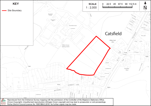
The site is allocated for residential development comprising 20 dwellings.
Development on this site must:
- Provide a policy-compliant amount of on-site affordable housing in line with policy HOU2 of the Rother Local Plan
- Include a new vehicular access from the adjacent site, CT1, across the Public Right of Way, with necessary improvements and safety measures as required by the Highway Authority.
- Provide pedestrian links to the 1066 Public Right of Way to the north-eastern boundary of the site.
- Include an area of public open space across the southern part of the site in line with the ratios indicated above.
- Protect the setting of the Grade II listed buildings (Broomham and Barn at Broomham) located nearby to the north-west.
- Be planned to ensure future access to existing sewerage infrastructure for maintenance and upsizing purposes.
12.77The site comprises a portion of a relatively well-contained field, divided into paddocks, adjacent to existing built development in the village of Catsfield, suitable for small-medium scale residential development. The site is well located in relation to village services.
12.78The site is within the Village Area Type, has a site size of 1.23 hectares and an indicative developable area of 0.6 hectares. It is allocated for some 20 dwellings at an indicative residential density of 35 dwellings per hectare.
12.79The site is located within the High Weald National Landscape and therefore a sensitive form of development is required in line with Local Plan policies. Built development should largely be limited to the north-eastern part of the site, with remaining land retained as public open space and to accommodate Biodiversity Net Gain and sustainable drainage measures.
12.80Environmental and other constraints affecting the site include an area of surface water flooding associated with a small stream the runs along the southern boundary of the site, in addition to Grade II Listed Buildings (Broomham and Barn at Broomham to the South East of the House) being located nearby to the north-west and a public right of way running adjacent to the northern boundary, with the policy requirements detailed above to reflect these. The site has high potential for prehistoric, Roman and medieval archaeological remains. Appropriate archaeological assessment will need to be undertaken in support of a planning application for its future development. The findings of the assessment may need to inform the layout and design of the proposal.
12.81The site’s main constraint is vehicular access. This will not be possible via the existing private lane east of the site due to the narrow width of the lane and there being no scope for widening or improvement. Consequently, the only possible vehicular access route would be via the adjacent allocated site to the north-east (Policy CT1, Land west of the B2204), across the public right of way, which also forms part of the 1066 Country Walk. The route will need to be carefully designed to ensure the safety and protection of amenity of users of the footpath, furthermore, the loss of a section of the mature tree line on the south-western boundary of the adjacent site would need to be minimised and compensated.
Policy CT3: Land south of Church Road, Catsfield. Comment
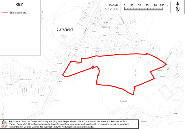
The site is allocated for residential development comprising 35 dwellings.
Development on this site must:
- Provide a policy-compliant amount of on-site affordable housing in line with policy HOU2 of the Rother Local Plan.
- Provide vehicular access from Church Road.
- Provide pedestrian and cycle links to Church Road and The Green (B2204).
- Provide crossing points to the pathways opposite the site on Church Road.
- Include provision for the retention and future management of a buffer zone of semi-natural habitat, at least 15 metres wide (which does not include residential gardens), on the southern boundary, between the edge of development and the Ancient Woodland.
- Be designed and laid out to take account of existing areas of surface water flood risk and high groundwater levels within the site, as informed by a site-specific flood risk assessment and to include the provision of appropriate sustainable drainage measures in accordance with Policy ENV2.
- Be planned to ensure future access to existing sewerage infrastructure for maintenance and upsizing purposes.
- Protect the setting of the Grade II Listed Buildings (Brooksidedatchett Dene, Pear Tree Cottage and 4 and 5 Broadley View) adjacent to the north boundary of the site.
12.82This site comprises a large field located between Church Road and Powdermill Lane in the southern part of the village of Catsfield.
12.83The site is within the Village Area Type, has a site size of 3.11 hectares and an indicative developable area of 1 hectare. It is allocated for some 35 dwellings at an indicative residential density of 35 dwellings per hectare.
12.84The site lies just outside the High Weald National Landscape although is within its setting. Other environmental and heritage constraints affecting the site include Ancient Woodland and Priority Habitat to the southern boundary and three Grade II Listed Buildings to the northern boundary. The area defined as woodland and habitat is also an Area of Potential Importance for Biodiversity, and the site contains two pockets of Areas that Could become of Importance for Biodiversity as defined by the East Sussex Local Nature Recover Strategy (ESLNRS). Any proposed scheme will therefore be required to take opportunities to provide Biodiversity Net Gain which contributes to the measures and objectives of the ESLNRS.
12.85The northern and western sections of the site are at risk of surface water flooding, and there are high groundwater levels. This means that a careful layout and design, and appropriate sustainable drainage measures will be required, to avoid development in areas at risk of flooding and ensure development is safe from flooding and does not increase flood risks elsewhere. Early consultation with the Lead Local Flood Authority will be required.
12.86The site is well related to the built form of the village, and in landscape terms, can accommodate a medium scale residential development across the south and eastern part of the site only, subject to a sensitive design. The remainder of the site would remain undeveloped and could accommodate sustainable drainage features, public open space and biodiversity net gain.
12.87The site is well located in relation to village services, however, a crossing point from the site would be required to enable occupiers to access the kerbside path on Church Road.
Netherfield
Parish: Battle
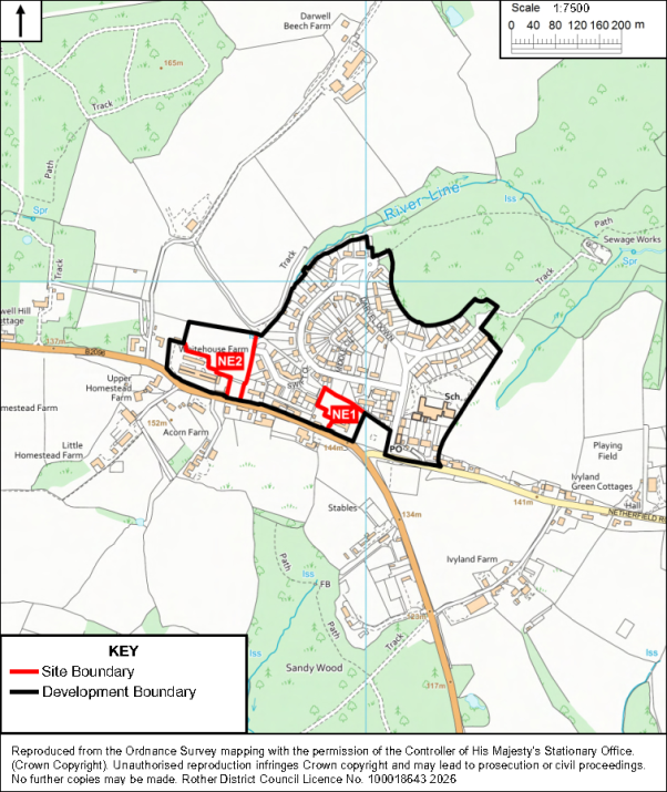
Policy NE1: Swallow Barn, Netherfield. Comment
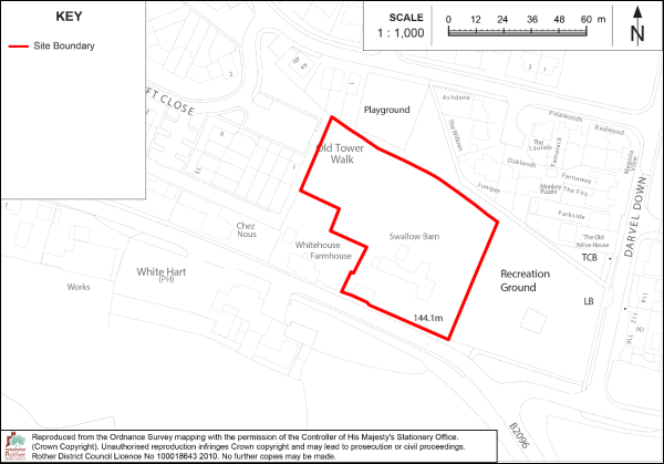
The site is allocated for residential development comprising 10 dwellings.
Development on this site must:
- Provide a policy-compliant amount of on-site affordable housing in line with policy HOU2 of the Rother Local Plan.
- Include a new vehicular access from Battle Road (B2096).
- Include new pedestrian and cycle links to Battle Road (B2096).
- Include pedestrian links to the adjacent recreation ground and playground.
- Retain the existing trees and hedgerow flanking the east and north boundaries of the site.
12.89The site comprises a relatively contained site consisting of a dwelling and wrap around land, located adjacent to existing built development in the village of Netherfield, suitable for small scale residential development.
12.90The site is within the Village Area Type, has a site size of 0.43 hectares and an indicative developable area of 0.28 hectares. It is allocated for some 10 dwellings at an indicative residential density of 35 dwellings per hectare. The allocation is carried forward from the Battle Neighbourhood Development Plan.
12.91It is within the High Weald National Landscape and therefore a sensitive form of development is required in line with Local Plan policies. Environmental and other constraints include a strong hedgerow and tree boundary to the east and north boundaries of the site with the policy requirements detailed above to reflect these. Further, because the site is within the Pevensey Levels Hydrological Catchment Area, mitigation measures to protect against significant effects to the Pevensey Levels SAC/ Ramsar Habitats Site may be required.
12.92The site is well located in relation to village services but improvements to pedestrian and cycle infrastructure to encourage active travel are required, particularly to link the site to the nearby recreation area, as detailed above.
Policy NE2: White House Poultry Farm, Netherfield. Comment
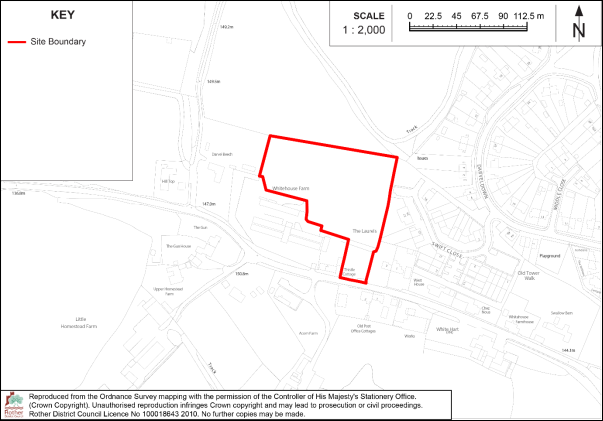
The site is allocated for residential development comprising 24 dwellings.
Development on this site must:
- Provide a policy-compliant amount of on-site affordable housing in line with policy HOU2 of the Rother Local Plan
- Include a new vehicular access from Battle Road (B2096)
- Include new pedestrian and cycle links to Battle Road and Swift Close
- Include an area of public open space in line with the ratios indicated above.
- Mitigate any significant effects on the Pevensey Levels Hydrological Catchment Area rising from construction or occupancy of the site and include mitigation measures as necessary to protect against significant effects to water quality in the Pevensey Levels SAC/ Ramsar.
- Protect the setting of the Grade II Listed Building (Darwell Beach) to the west of the site.
12.93The site comprises part of a larger field adjacent to existing built development in the village of Netherfield, suitable for small scale residential development. It is within the High Weald National Landscape and therefore a sensitive form of development is required in line with Local Plan policies.
12.94The site is within the Village Area Type, has a site size of 0.98 hectares and an indicative developable area of 0.68 hectares. It is allocated for some 24 dwellings at an indicative residential density of 35 dwellings per hectare.
12.95Environmental and other constraints affecting the site include being located adjacent to a Grade ll Listed Building (Darwell Beach) to the west of the site with policy requirements detailed above to reflect these. Further, because the site is within the Pevensey Levels Hydrological Catchment Area, mitigation measures to protect against significant effects to the Pevensey Levels SAC/ Ramsar Habitats Site may be required. The site is relatively well located in relation to village services but improvements to pedestrian and cycle infrastructure to encourage active travel are required, as detailed above. The site benefits from an extant planning permission but development has not yet commenced, and the policy requirements reflect the requirements of the planning permission.
Sedlescombe
Parish: Sedlescombe
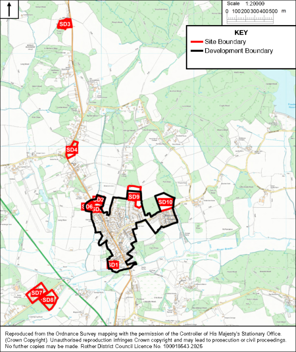
Policy SD1: Land at Sunningdale, Sedlescombe. Comment
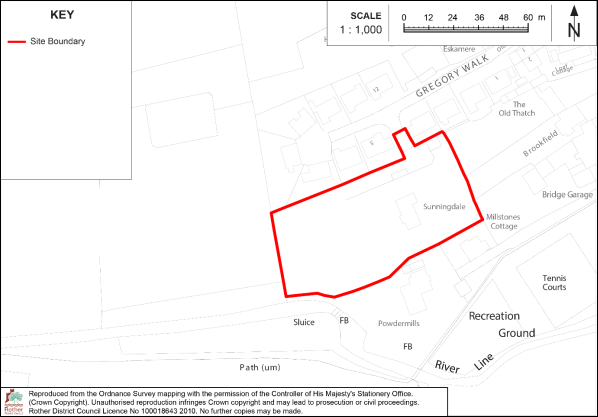
The site is allocated for residential development comprising 8 dwellings.
Development on this site must:
- Provide a policy-compliant amount of on-site affordable housing in line with policy HOU2 of the Rother Local Plan.
- Include a new vehicular access from Gregory Walk.
- Include new pedestrian and cycle links to Gregory Walk.
- Retain and enhance the existing hedgerow/ trees on all boundaries of the site.
12.96The site comprises a field in close proximity to existing built development in the village of Sedlescombe and within the High Weald National Landscape.
12.97The site is within the Village Area Type, has a site size of 0.47 hectares and an indicative developable area of 0.32 hectares. It is allocated for some 8 dwellings at an indicative residential density of 35 dwellings per hectare.
12.98Having regard to existing residential development on the opposite site of Gregory Walk, it is considered that a small-scale residential development is acceptable across the eastern part of the site, subject to a sensitive design.
12.99Environmental and other constraints affecting the site include the site being in an archaeological notification area, adjacent to Sedlescombe Conservation Area, being located adjacent to historic field boundaries and small areas on the southern boundary being within Flood Risk Zones 2 and 3 and at risk of surface water flooding with the policy requirements detailed above to reflect these. The site also directly borders to the west and south, Areas that Could become of Importance for Biodiversity as defined by the East Sussex Local Nature Recover Strategy (ESLNRS). Any proposed scheme will therefore be required to take opportunities as part of the Biodiversity Net Gain scheme to contribute to the measures and objectives of the ESLNRS.
12.100The site is well located in relation to village services but improvements to pedestrian and cycle infrastructure to encourage active travel are required, as detailed above. The allocation is carried forward from the Sedlescombe Neighbourhood Development Plan.
Policy SD2: Land at Church Hill Farm, Sedlescombe. Comment
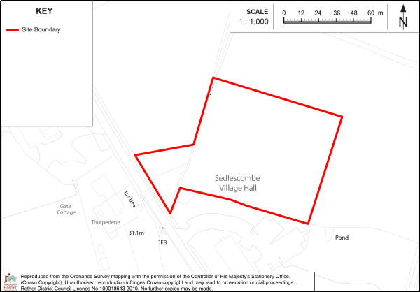
The site is allocated for residential development comprising 12 dwellings.
Development on this site must:
- Provide a policy-compliant amount of on-site affordable housing in line with policy HOU2 of the Rother Local Plan
- Include a new vehicular access from The Street via Church Hill.
- Include new pedestrian and cycle links to The Street via Church Hill.
- Retain and enhance the existing hedgerow/ trees on the south and western boundaries of the site
12.101The site comprises a section of a larger field in close proximity to existing built development in the village of Sedlescombe and within the High Weald National Landscape.
12.102The site is within the Village Area Type, has a site size of 0.82 hectares and an indicative developable area of 0.32 hectares. It is allocated for some 12 dwellings at an indicative residential density of 35 dwellings per hectare.
12.103Having regard to the existing village hall to the south of the site, it is considered that a small-scale residential development is acceptable across the southern part of the site, subject to a sensitive design.
12.104Environmental and other constraints affecting the site include the site being in an archaeological notification area, containing Lowland Meadows Priority Habitat to the south-west, being located adjacent to historic field boundaries and small areas on the southern-western boundary being at risk of surface water flooding with the policy requirements detailed above to reflect these. The site is also wholly within an Area that Could become of Importance for Biodiversity as defined by the East Sussex Local Nature Recover Strategy (ESLNRS). Any proposed scheme will therefore be required to take opportunities to provide Biodiversity Net Gain which contributes to the measures and objectives of the ESLNRS.
12.105 The site is well located in relation to village services but improvements to pedestrian and cycle infrastructure to encourage active travel are required, as detailed above. The allocation is carried forward from the Sedlescombe Neighbourhood Development Plan.
Policy SD3: Land at Sedlescombe Sawmills, Sedlescombe. Comment
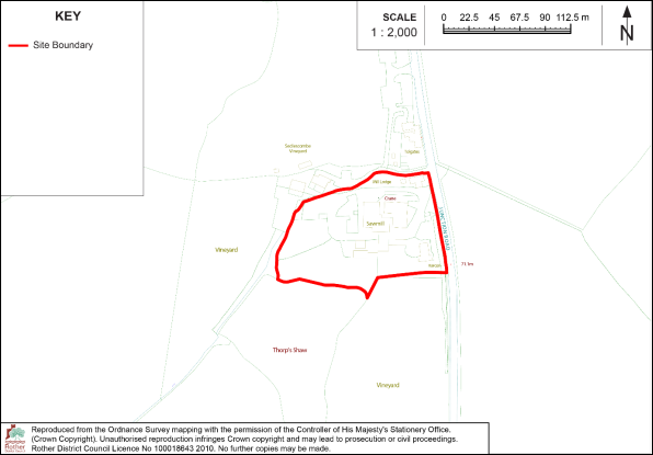
The site is allocated for a mixed-use development comprising:
- 8 new dwellings
- 1,115 sqm of new employment floorspace
Development on this site must:
- make provision for a residential scheme, provided:
- the number of dwellings is assessed to be the minimum required to cross-subsidise the employment scheme, based on a submitted viability appraisal;
- the design of all the dwellings makes sufficient provision for dedicated office and/or workshop space for the benefit of the occupants; and
- includes the demolition of existing buildings and structures that detract from the scenic beauty of the adjoining landscape.
- Include a new vehicular access from Junction Road.
- Include a link to the nearby Public Right of Way.
- Preserve the area of the site designated as Priority Habitat and include a suitable undeveloped buffer around the area.
- Include provision for the retention and future management of a buffer zone of semi-natural habitat, at least 15 metres wide (which does not include residential gardens), on the south-west boundary, between the edge of development and the Ancient Woodland.
- Retain and enhance the existing hedgerow/ trees to all boundaries of the site.
12.106The site comprises a partially derelict sawmill with open space intertwined by derelict business units and sawmill structures, in close proximity to a vineyard to the west and therapy centre to the north, north of the village of Sedlescombe and within the High Weald National Landscape.
12.107The site is within the Countryside Area Type, has a site size of 1.16 hectares and an indicative developable area of 0.69 hectares. It is allocated for some 8 dwellings at an indicative residential density of 30 dwellings per hectare.
12.108Having regard to existing development referenced above, it is considered that a small-scale mixed-use development can be accepted across the site, subject to a sensitive design.
12.109Environmental and other constraints affecting the site include Ancient woodland adjacent to the south-western boundary, an area of Priority Habitat in the south-west corner, small area at risk of surface water flooding, being within an Archaeological Notification Area, located adjacent to Historic field boundaries and a Public Right of Way nearby, with the policy requirements detailed above to reflect these. The area defined as a Priority Habitat is also part of a wider Area that Could become of Importance for Biodiversity as defined by the East Sussex Local Nature Recover Strategy (ESLNRS). Any proposed scheme will therefore be required to take opportunities to provide Biodiversity Net Gain which contributes to the measures and objectives of the ESLNRS.
12.110The site is not well located in relation to village services; however, the policy encourages a mixed-use scheme to enable sufficient development value to be generated to cross-subsidise a viable employment scheme, which will also provide links to the Public Right of Way. The allocation is carried forward from the Sedlescombe Neighbourhood Development Plan.
Policy SD4: Land adjacent to St John the Baptist Church, Sedlescombe. Comment
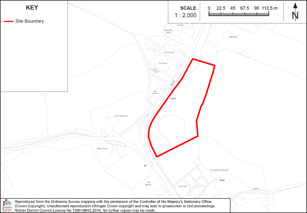
The site is allocated for residential development comprising 17 dwellings.
Development on this site must:
- Provide a policy-compliant amount of on-site affordable housing in line with policy HOU2 of the Rother Local Plan
- Include a new vehicular access from the B2244.
- Include new pedestrian and cycle links to the B2244.
- Retain and enhance the existing hedgerow/ trees on all boundaries of the site.
- Make provision for a community benefit scheme, comprising:
- a car park to serve the Church of at least 30 spaces, which can be used by cars and coaches for dropping off and collecting Church visitors;
- the use of the Church facilities by the local community during the entire year and during evenings;
- a renewable energy heating solution to service the new homes and the Church;
- a restoration scheme of the Church, including interior alterations to make the space more usable for community activities;
- Protect the setting of the Grade II Listed Building (The Parish Church of St John the Baptist) to the south-east of the site.
12.111The site comprises a well-contained field in close proximity to existing built development in the village of Sedlescombe and within the High Weald National Landscape.
12.112The site is within the Village Area Type, has a site size of 1.16 hectares and an indicative developable area of 0.46 hectares. It is allocated for some 17 dwellings at an indicative residential density of 35 dwellings per hectare.
12.113Having regard to existing residential development on the B2244 (Sandrock Hill), it is considered that a small/ medium scale residential development is acceptable across the site, subject to a sensitive design.
12.114Environmental and other constraints affecting the site include the site being in an archaeological notification area, being located adjacent to historic field boundaries, a Grade II Listed Building (The Parish Church of St John the Baptist) nearby and small areas on the adjacent road being at risk of surface water flooding with the policy requirements detailed above to reflect these. The site also directly borders to the south-east an Area that Could become of Importance for Biodiversity as defined by the East Sussex Local Nature Recover Strategy (ESLNRS). Any proposed scheme will therefore be required to take opportunities as part of the Biodiversity Net Gain scheme to contribute to the measures and objectives of the ESLNRS.
12.115The allocation is carried forward from the Sedlescombe Neighbourhood Development Plan. This emphasises that only the minimum number of units required to deliver the community benefit scheme set out in vii (evidenced by a financial viability appraisal) should be provided on the site, with the overarching aim of development on this site being to secure a financially sustainable church and community services.
12.116The site is relatively well located in relation to village services but improvements to pedestrian and cycle infrastructure to encourage active travel are required, as detailed above.
Policy SD5: Land at Gate Cottage, Sedlescombe. Comment
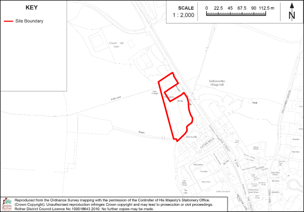
The site is allocated for residential development comprising 8 dwellings.
Development on this site must:
- Provide a policy-compliant amount of on-site affordable housing in line with policy HOU2 of the Rother Local Plan
- Include a new vehicular access from The Street.
- Include new pedestrian and cycle links to The Street, including a crossing point to reach east side of The Street (where improvements will be required to footway width).
- Retain the existing Public Right of Way that runs adjacent to the northern boundary.
- Retain and enhance the existing hedgerow/ trees on the east and south boundaries of the site.
12.117The site comprises a parcel of land in close proximity to existing built development in the village of Sedlescombe and within the High Weald National Landscape.
12.118 The site is within the Village Area Type, has a site size of 0.39 hectares and an indicative developable area of 0.23 hectares. It is allocated for some 8 dwellings at an indicative residential density of 35 dwellings per hectare.
12.119Development of the site will likely impact on High Weald character features, however, having regard to existing residential development on The Street, it is considered that a small-scale residential development is acceptable across the site, subject to a sensitive design.
12.120Environmental and other constraints affecting the site include the site being located adjacent to a Public Right of Way to the north, being in an archaeological notification area, and small areas on the eastern boundary being at risk of surface water flooding with the policy requirements detailed above to reflect these.
12.121The site is well located in relation to village services but improvements to pedestrian and cycle infrastructure to encourage active travel are required, as detailed above. The allocation is carried forward from the Sedlescombe Neighbourhood Development Plan.
Policy SD6: Land at Church Hill Farm, Sedlescombe. Comment
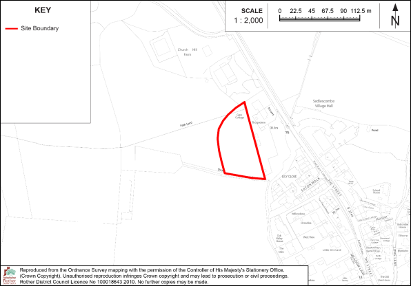
The site is allocated for residential development comprising 10 dwellings.
Development on this site must:
- Provide a policy-compliant amount of on-site affordable housing in line with policy HOU2 of the Rother Local Plan
- Include a new vehicular access from the adjacent allocated site SD5.
- Include new pedestrian and cycle links to the adjacent allocated site SD5.
- Retain the Public Right of Way that runs through the northern boundary of the site.
12.122The site comprises a field in close proximity to existing built development in the village of Sedlescombe and within the High Weald National Landscape.
12.123The site is within the Village Area Type, has a site size of 0.46 hectares and an indicative developable area of 0.32 hectares. It is allocated for some 10 dwellings at an indicative residential density of 35 dwellings per hectare.
12.124Development of the site will impact on High Weald character features, however, having regard to existing residential development on The Street, it is considered that a small-scale residential development is acceptable across the site, subject to a sensitive design.
12.125Environmental and other constraints affecting the site include the site being in an archaeological notification area, a Public Right of Way running through the northern boundary of the site and small areas on the southern boundary being at risk of surface water flooding with the policy requirements detailed above to reflect these.
12.126 The site is well located in relation to village services but improvements to pedestrian and cycle infrastructure to encourage active travel are required, as detailed above. The allocation is carried forward from the Sedlescombe Neighbourhood Development Plan.
Policy SD7: Marley Lane Business Park, Marley Lane. Comment
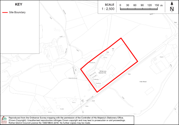
The site is allocated for employment development comprising some 2,400sqm of new employment floorspace (use class E(g), B2 or B8).
Development on this site must:
- Use the existing vehicular access from Marley Lane.
- Include provision for the retention and future management of a buffer zone of semi-natural habitat, at least 15 metres wide on the site boundaries, between the edge of development and the Ancient Woodland, and also around the Ancient Woodland within the site.
- Retain a suitable undeveloped buffer area to the designated Priority Habitat surrounding and within the site.
12.127The site comprises a well-contained business park located on the northern side of Marley Lane, close to its junction with the A21 and outside of any settlement, in the parish of Sedlescombe within the High Weald National Landscape. The Marley Lane Business Park comprises two large industrial buildings and associated car parking and forecourt areas, together with a large, open, grassed area in its eastern section which is surrounded by Ancient Woodland on three boundaries, much of which is protected with a Tree Preservation Order.
12.128 The site is within the Countryside Area Type, has a site size of 2.38 hectares and an indicative developable area of 0.83 hectares.
12.129The undeveloped eastern section of the site is considered suitable for employment development, subject to a sensitive design and appropriate buffers to the Ancient Woodland and Priority Habitat surrounding the site and extending into it, and Tree Preservation Orders on the site’s boundaries.
12.130 While the site is outside any settlement, it has good access to the strategic road network and forms part of an established business estate and is appropriately located for these uses. National planning policy supports the sustainable growth and expansion of all types of business in rural areas, recognising that sites in rural areas may have to be found beyond existing settlements. The allocation provides flexibility in terms of the specific use class of the employment use. The appropriate use class would be for determination at planning application stage, having regard to the nature of the particular proposal and the site constraints
Policy SD8: Land at Felon’s Field, Marley Lane. Comment
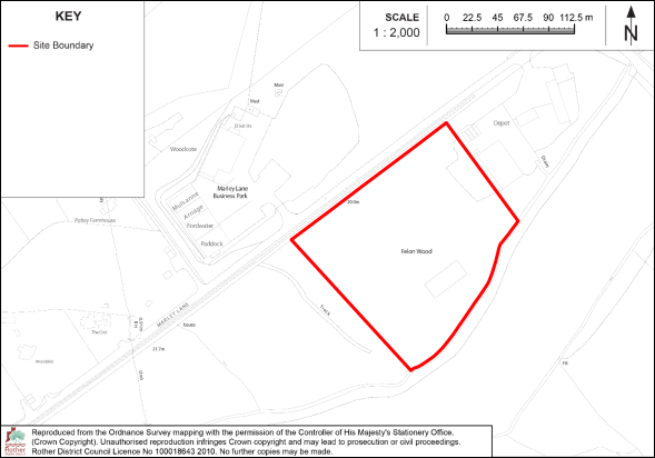
The site is allocated for employment development comprising 3000sqm of new employment floorspace (use class E(g), B2 or B8).
Development on this site must:
- Provide a new vehicular access from Marley Lane.
- Retain trees subject to Tree Preservation Orders and retain and strengthen boundary tree belts with native species.
- Be informed by a biodiversity strategy that makes provision for any protected species found to be using the site, and where necessary, includes appropriate mitigation and/ or compensation for any loss of habitat.
- Include measures to ensure no adverse effect on ground water
12.131 The site comprises an overgrown undeveloped field, with a central part that is hard surfaced. It is well-contained by woodland to the north, west and south boundaries, located in close proximity to an existing industrial area to the east and Marley Lane Business Park located opposite to the west, in the parish of Sedlescombe within the High Weald National Landscape.
12.132The site is within the Countryside Area Type, has a site size of 2.27 hectares and an indicative developable area of 1.02 hectares.
12.133Having regard to nearby industrial development, it is considered that a medium scale industrial development is acceptable, subject to a sensitive design. The allocation provides flexibility in terms of the specific use class of the employment use. The appropriate use class would be for determination at planning application stage, having regard to the nature of the particular proposal and the site constraints.
12.134Environmental and other constraints affecting the site include thick tree belts on all boundaries, other than the north-eastern boundary, including a single Oak in the central part of the site, all of which are protected by a Tree Preservation Order (TPO). A groundwater protection zone and an area of flood risk lie to the south, with evidence of protected species, including dormice, using the site. In addition, the site has potential archaeological interest due to its location within an area of medieval and post-medieval activity.
12.135The site is overgrown and is likely to accommodate wildlife habitats and potentially protected species. Up-to-date ecological surveys and tree surveys will be required to ascertain the precise amount and layout of development at this location.
12.136While the site lies outside any settlement, it has good access to the strategic road network and is appropriately located for business uses. National planning policy supports the sustainable growth and expansion of all types of business in rural areas, recognising that sites in rural areas may have to be found beyond existing settlements.
Policy SD9: Land north of Gorselands, Sedlescombe. Comment
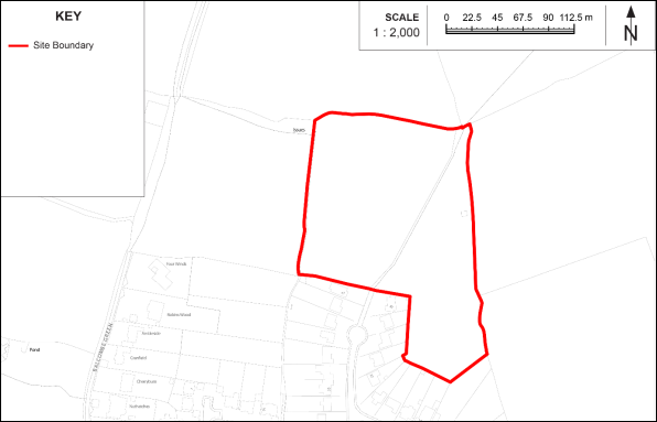
The site is allocated for residential development comprising 15 dwellings.
Development on this site must:
- Provide a policy-compliant amount of on-site affordable housing in line with policy HOU2 of the Rother Local Plan
- Include a new vehicular access from Gorselands.
- Include new pedestrian and cycle links to Gorselands.
- Include an area of public open space in line with the ratios indicated above.
- Include provision for the retention and future management of a buffer zone of semi-natural habitat, at least 15 metres wide (which does not include residential gardens), on the northern and south-eastern boundaries, between the edge of development and the Ancient Woodland and Priority Habitat;
- Retain and enhance the existing hedgerows and trees on the north, east and west boundaries of the site.
- Retain and provide links to the public right of way that dissects the site from the access at Gorselands to the north-eastern corner.
12.137The site comprises a sloping field on the northern edge of Sedlescombe village, within the High Weald National Landscape. The south-eastern section is well contained by boundary trees and ancient woodland, while the western/ northern section is more exposed in the landscape.
12.138The site is within the Village Area Type, has a site size of 2.62 hectares and an indicative developable area of 0.52 hectares. It is allocated for some 15 dwellings at an indicative residential density of 35 dwellings per hectare.
12.139Having regard to adjoining residential development at Gorselands to the south of the site, it is considered that a small/ medium scale residential development is acceptable across the south-eastern part of the site, to be informed by a landscape and visual impact assessment to determine an appropriate layout, form and detailed design.
12.140Environmental and other constraints affecting the site include Priority Habitat woodland (which is also protected by a Tree Preservation Order) to the south-eastern boundary, Lowland Meadows Priority Habitat to the west, Ancient Woodland to the northern boundary, a public right of way that dissects the site from north to south, and historic field boundaries, with the policy requirements detailed above to reflect these. The site also directly borders to the north, west and south-east Areas that Could become of Importance for Biodiversity as defined by the East Sussex Local Nature Recover Strategy (ESLNRS). Any proposed scheme will therefore be required to take opportunities to link these areas as appropriate as part of the Biodiversity Net Gain scheme, which contribute to the measures and objectives of the ESLNRS.
12.141The site is relatively well-located in relation to village services but improvements to pedestrian and cycle infrastructure to encourage active travel are required, as detailed above. The access road would need to be widened to serve a development.
Policy SD10: Land north of Brede Lane, Sedlescombe. Comment
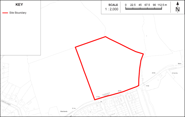
The site is allocated for residential development comprising 38 dwellings.
Development on this site must:
- Provide a policy-compliant amount of on-site affordable housing in line with policy HOU2 of the Rother Local Plan
- Include a new vehicular access from Brede Lane.
- Include new pedestrian and cycle links to Brede Lane.
- Include provision for the retention and future management of a buffer zone of semi-natural habitat, at least 15 metres wide (which does not include residential gardens), on the eastern and western boundaries, between the edge of development and the Ancient Woodland and Priority Habitat;
- Retain and enhance the existing hedgerow on the southern boundary of the site, save for a short section to be removed to facilitate an access.
- Provide a tree belt of oak and field maple with understorey scrub along the north-western edge of the site to improve connectivity between adjacent woodland blocks and reinforce the deciduous belt to the east along the streamside;
- The layout of development should be informed by an odour assessment to be undertaken in consultation with statutory wastewater operator for the works.
12.142The site comprises approximately half of a large, irregularly shaped field abutted by Ancient Woodland and Priority Habitat on the northern side of Brede Lane, east of Sedlescombe village. There is a well-established hedgerow to the southern (roadside) boundary and the adjoining woodland to the west is protected by a Tree Preservation Order.
12.143 The site is within the Village Area Type, has a site size of 2.76 hectares and an indicative developable area of 1.1 hectares. It is allocated for some 38 dwellings at an indicative residential density of 35 dwellings per hectare.
12.144Environmental and other constraints affecting the site include Priority Habitat adjacent to the western boundary (which is also protected by a Tree Preservation Order), Ancient Woodland to the eastern boundary and small areas at risk of surface water flooding to the south-east of the site. The identified habitat and woodland areas are also Areas that Could become of Importance for Biodiversity as defined by the East Sussex Local Nature Recover Strategy (ESLNRS). Any proposed scheme will therefore be required to take opportunities to link these areas as appropriate as part of the Biodiversity Net Gain scheme, which contribute to the measures and objectives of the ESLNRS.
12.145The site is located within the High Weald National Landscape (HWNL) and occupies an edge-of-settlement location which is well enclosed by Ancient Woodland to the north-east, a Deciduous woodland belt to the south-east and a block of Deciduous woodland to the west with a hedgerow enclosing the south. The primary HWNL characteristic present here is a small, irregular field bound by Ancient Woodland and hedgerows. The design response should therefore retain hedgerows and trees to the site boundaries, whilst taking the opportunity to provide a tree belt of oak and field maple with understorey scrub along the north-western edge of the site to improve connectivity between adjacent woodland blocks and reinforce the deciduous belt to the east along the streamside. The built form should be arranged to respond to the topography and existing landscape structure with a varied density strategy, which will ensure appropriate buffers are secured to the Ancient Woodland and hedgerows. It is anticipated that any greater density is focused only where it can be accommodated without harm to landscape character and hedgerows. Overall, the policy requirements and the mitigation measures required will ensure the development conserves and enhances the natural beauty of the HWNL.
12.146The site is within walking distance of services and facilities in the village although improvements to pedestrian and cycle infrastructure to encourage active travel are required.
