
Rother Local Plan 2025-2042 Regulation 19 (pre-submission) version September 2026
Chapter 7: Natural & Historic Environment
Landscape Character, Woodlands & Trees
Policy LAN1: Landscape Character & Stewardship Comment
|
Policy Status |
Strategic |
|
Overall Priorities |
Green to the Core |
|
Strategic Objectives |
3, 4 |
|
|
|
Key evidence and/or guidance
|
|
7.1National planning policy requires the Local Plan set a framework for protecting and enhancing the natural and local environment, as an integral part of delivering sustainable development.
7.2Rother’s landscape is of great environmental and economic importance. It also plays an important social role by contributing to a sense of local identity, as well as supporting people’s health and well-being. The landscape is a combination of cultural, historical and physical characteristics and components, which give rise to patterns that are distinctive to particular localities in the district and help to define a sense of place.
7.3The purpose of the policy is to provide protection for areas of landscape value across the whole district, requiring development proposals to be in keeping with, and maintain and reinforce, the positive characteristics of the different areas. In addition, Policy LAN2 (High Weald National Landscape) sets reflects the importance and prevalence of the designated AONB within Rother.
7.4The East Sussex Landscape Character Assessment (LCA)[122] provides detailed descriptions of the distinctive landscape character areas at a local level, reflecting the particular pattern of elements derived from geology, landform, topography, flora and fauna, physical features and settlement. The LCA Index Map, as it relates to Rother is reproduced below, Figure 7.1. This illustrates that the district is made up of distinct local landscapes, indeed, Rother includes land within thirteen Local Landscape Character Areas:
- Character Area 5 – South Slopes of High Weald
- Character Area 6 – Upper Rother Valley
- Character Area 7 – Bewl Water Area
- Character Area 8 – Dudwell Valley
- Character Area 9 – Darwell Valley
- Character Area 10 – Combe Haven Valley
- Character Area 11 – Brede Valley
- Character Area 12 – High Wealden Coast
- Character Area 13 – Lower Rother Valley
- Character Area 26 – Rye Winchelsea Area
- Urban Area 30 – Bexhill
- Urban Area 39 - Rye
- Urban Area 40 - Battle
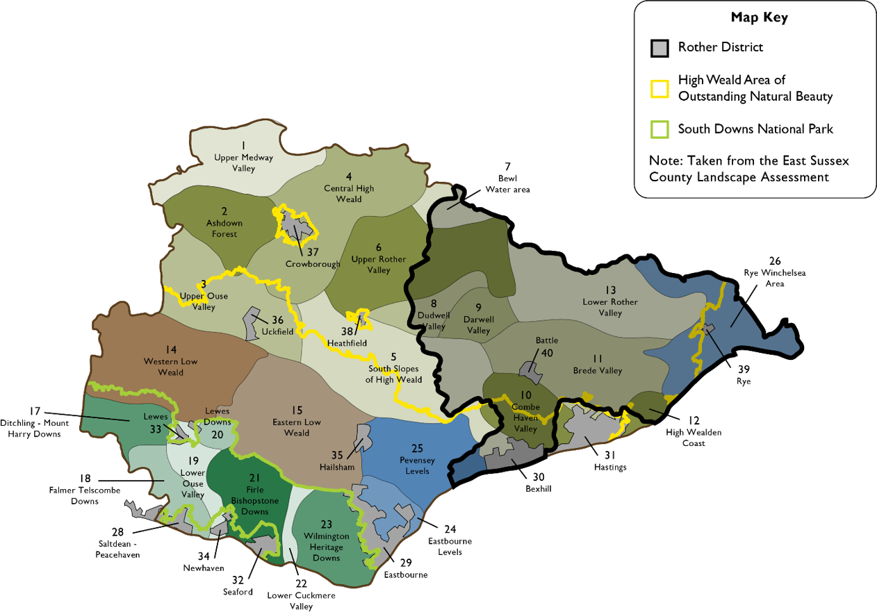
7.5Each of the Character Areas has its own landscape characteristics, positive landscape attributes and pressures for change. The key features, “action priorities”, opportunities for protection and enhancement, and guidelines for landscape management for each character area are identified in the LCA. This will assist applicants in identifying the important characteristics of the landscape in which a proposed development is located and should be referred to in considering development proposals, to meet the requirements of Policy LAN1.
7.6Two predominantly rural areas with important landscape features, lying outside the High Weald NL, are the Pevensey Levels and Romney Marshes. The Pevensey Levels are a low-lying tract of reclaimed wetland to the west of Bexhill at the western edge of the district that continues into Wealden District. They are typically a flat open landscape with extensively grazed wet meadows, largely windswept with a few trees. Widely spaced roads and isolated small settlements provide a sense of remoteness in this area, which is a priority habitat due to its designation as a Ramsar site and Special Area of Conservation (SAC).
7.7The Romney Marshes are located around Rye to the east of the district and continue into Folkestone and Hythe District. This area is typically a flat open agricultural landscape of arable fields and wet pastureland with distinctive drainage dykes, marshes and notable open skies. The area also comprises habitats of the highest nature conservation value, being designated as a Ramsar, Special Protection Area (SPA) and SAC. There is a sharp contrast between the shingle coast, low lying agricultural land and raised cliffs in this wider area. The former sea cliffs mark the post glacial shoreline, and the Royal Military Canal can be found at the base of the cliffs. The wider area is characterised by narrow straight roads and dispersed settlements with an open character and general feeling of remoteness.
Policy LAN2: High Weald National Landscape Comment
|
Status |
Strategic |
|
Priorities |
Green to the Core, Live Well Locally |
|
Strategic Objectives |
3, 9 |
|
|
|
Key evidence and/or guidance
|
|
7.8Rother district is predominantly rural in nature, with 83% of the district being located within the High Weald Area National Landscape, which is a designated Area of Outstanding Natural Beauty (AONB) and a national asset.
Statutory protection
7.9A National Landscape, or AONB, is an area of land protected by the Countryside and Rights of Way (CRoW) Act 2000 for its outstanding natural beauty. The CRoW Act provides that the single statutory purpose of Areas of Outstanding Natural Beauty is the conservation and enhancement of the natural beauty of the area. The CRoW Act was amended in 2023[124] to create a new statutory duty on relevant authorities (including Local Planning Authorities), requiring them to “seek to further the purpose of conserving and enhancing the natural beauty of the area” when discharging their functions in National Landscapes. The duty applies not only in considering proposals within an AONB but also for proposals affecting its setting.
7.10 “Natural beauty” is not just the look of the landscape but includes landform and geology, plants and animals, landscape features, and the rich history of human settlement over the centuries[125]. It includes landscape and scenic quality, natural heritage (species, habitats, geology and physical geography), wildness, tranquillity and dark skies, and cultural heritage (including cultural traditions and the historic and other built environment that makes the area unique). Historic England makes clear that the historic environment is fundamental to the distinctive character, sense of place and natural beauty of each AONB.[126]The High Weald AONB Management Plan 2024-2029 is the primary document defining the natural beauty of the High Weald.
7.11The provisions of the CRoW Act are reflected in national planning policy. This policy aligns with national planning policy while making the requirements specific to the High Weald National Landscape in Rother.
7.12It should be noted that developments for housing, commercial, renewable energy, health and well-being and tourism uses are the subject of additional separate policies in the Local Plan, with the emphasis on locations outside of the High Weald National Landscape and, where appropriate, within them on a small scale, in accordance with Policy LAN2.
The High Weald National Landscape character and key issues
7.13The High Weald National Landscape (NL) was designated as an AONB in 1983. It includes land within four counties, with 30% of its land area falling within Rother district. It is characterised by being one of the best surviving, medieval landscapes in Northern Europe. Over a quarter of its land comprises woodland, and it has the highest coverage of ancient woodland of any protected landscape. The High Weald rises above the Low Weald and contains distinctive and scattered sandstone outcrops. Main roads and settlements are sited along prominent ridgelines, with a further network of small winding lanes connecting scattered villages, hamlets and farms. The legacy of the early iron industry has resulted in extensive areas of coppice woodland and hammer ponds. Trees and vegetation have different characteristics in high forest, small woods and copses. Historic field boundaries are defined by a network of hedges and assarts (land created for arable use by clearing woodland).
7.14The area’s heavy clay soils have reduced the impact of agricultural change, in which mixed farming predominates in a quiet, small-scale pastoral landscape. The cultivation of fruit and hops together with the associated distinctive oast houses help define the area. Particularly locally distinctive building typologies and features include long sweeping catslide roofs, oast houses, timber-framed barns and other agricultural buildings associated with local historic farming practices, The built form deploys a limited palette of materials associated with the local High Weald geology, including clay tile, brick, local stone and timber in construction, and often includes hung tiles and/or white weatherboarding. It should be noted that the whole of the High Weald NL is designated for its outstanding natural beauty, and all the NL is important; any areas perceived as ‘degraded’ should be seen as opportunities for the enhancement of natural beauty, contributing positively to the objectives of the High Weald Management Plan.
7.15A key challenge in the High Weald NL is to balance the growth and development of settlements and rural economies, with conserving and enhancing its natural beauty, including managing impacts on landscape and settlement character and features. Suburbanisation of landscape character, including through conversion of farmstead buildings, new roads and highways works, and inappropriate edge of settlement development, is eroding the distinctive local style in many places. However, small-scale, more sensitive development, can, if located in the right places, improve the sustainability of settlements and clusters of settlements through the delivery of new services and facilities closer to where people live.
7.16Policy LAN2 includes reference to three important documents produced by the High Weald National Landscape Unit, which assist in the consideration and determination of planning applications. The High Weald AONB Management Plan 2024-2029 covers a range of Local Authorities’ functions and is a material consideration in the planning process, including assessing the impact of development proposals. The Management Plan sets out the core character components that comprise the natural beauty of the High Weald, and specific objectives and actions for each component. Figure 7.2 below identifies the Core Character Components of the High Weald’s natural beauty, as detailed in the Management Plan.
Figure 7.2: Core Character Components of the High Weald’s natural beauty[127]
|
Natural Systems (geology, soils, water, climate) |
Settlement |
Routeways |
Woodland |
|
Fieldscapes and Heath |
Dark Night Skies |
Aesthetic and Perceptual Qualities |
Land-based Economy and Rural Living |
7.17The High Weald AONB Housing Design Guide and other supporting guidance supports the objectives of the Management Plan, providing succinct, practical advice to set clear design expectations for new housing development. It aims to ensure the achievement of higher quality, landscape-led design that reflects intrinsic High Weald character, embedded with a true sense of place, without stifling innovation and creativity. Importantly, the guide is not solely focused on the appearance or style of individual buildings, but rather about creating successful places in terms of layout, grain and massing of development. The Housing Design Guide is broadly based on ‘Building for Life 12’, explaining how design principles should be applied in the specific context and distinctive character of the High Weald AONB. The guide is therefore in line with the Live Well Locally policies, which reflect Building for a Healthy Life (BHL). BHL has updated Building for Life 12, retaining the underlying principles.
7.18Part 4 of the policy specifically protects surviving evidence of the past. There is much evidence in the High Weald of, for example, ancient fortification; historic agricultural practice and the iron industry. This may take many forms, for example: earthworks, ponds, droveways and field patterns. Some features may constitute designated or non-designated heritage assets, benefiting from local and national planning policy protection, but others may be less clearly defined. Development proposals which could affect such features will be carefully considered to ensure their retention and enhancement as character features of the High Weald and valuable evidence of the past.
Policy LAN3: Trees, Woodlands and Hedgerows Comment
|
Status |
Strategic |
|
Priorities |
Green to the Core, Live Well Locally |
|
Strategic Objectives |
3 |
Protection of existing trees, hedgerows and woodlands
New tree planting
Replacement trees and canopy cover
Management and maintenance
|
|
|
Key evidence and/or guidance
|
|
7.19This policy is in line with national planning policy, which is clear that policies should ensure that new streets are tree-lined, that opportunities are taken to incorporate trees in developments, that appropriate measures are in place to secure the long-term maintenance of newly planted trees, that existing trees are retained wherever possible, and that irreplaceable habitats (such as ancient and veteran trees) are retained and protected.
7.20Trees, woodlands and hedgerows form the backbone of the district’s character, both in rural and urban areas. They provide social and environmental benefits to local communities, impacting positively on health and well-being, carbon sequestration, biodiversity, climate change adaptation and flood mitigation. The planting and retention of trees can significantly contribute to the successful integration of new development into the local environment and should be considered at the design stage of all development.
7.21The Council has passed a Motion on the Rights of Trees[130]. This confirms support for the growing global movement for rights of nature as a framework for rethinking the relationship between human beings and the natural world. It confirms that protection should be prioritised for trees that can be considered as a “heritage and/or cultural asset”. The Motion also confirms that the Council would support the introduction of legislation which would require those taking decisions affecting trees to have regard to the trees’ rights, including to exist and grow, have their wellbeing protected, and not to be wilfully injured, damaged, polluted or killed. While the Motion is wider than planning policy, this policy provides a framework for implementing it as far as possible through planning decisions, specifically by ensuring that existing trees and hedges are retained and protected wherever possible and that development takes the opportunity to enhance and expand the district’s tree, hedgerow and woodland resource.
Protection of existing trees, hedgerows and woodland
7.22The preservation of existing trees is a material consideration in the planning process, whether they are subject to existing statutory protection or not. Any construction work in close proximity to trees should be undertaken using appropriate techniques in accordance with the relevant British Standard (such as by hand and not machine), in accordance with a methodology submitted to and agreed by the Council before work starts on site.
7.23Proposals to remove a tree of amenity, historic, or high ecological value will require the submission of a CAVAT (Capital Asset Value for Amenity Trees) assessment. CAVAT is a method of tree valuation used as a strategic tool and aid to decision making for tree stock as a whole but also can be applicable to individual cases, where the value of a single tree needs to be expressed in monetary terms. The value of individual trees is important not only in amenity value but also in terms of biodiversity and contributing to wildlife connectivity across the district. The application of this system recognises that both individual and groups of trees can have significant value and any unavoidable loss will be sufficiently compensated with a tree of appropriate or equivalent size/ maturity.
Ancient woodland
7.24Ancient woodland and ancient and veteran trees are recognised through the NPPF as irreplaceable habitats, that is, habitats with characteristic ecological features and processes which cannot successfully be created, and which generally support important and/or rare species populations or assemblages. To mitigate negative impacts, a buffer zone consisting of semi-natural habitat should be employed between the development and the ancient woodland or veteran tree. In some cases, larger buffers than 15 metres for ancient woodland will be required especially for major residential developments. Buffers will need to exclude residential gardens and site infrastructure including, but not limited to, roadways and active travel routes, play areas and SuDS infrastructure. Ancient woodland comprises the habitat as a whole, including the soil, plants and wildlife, and therefore the function of the buffer is not only for root protection of the trees. Further detailed guidance for applicants on ancient woodland and veteran trees is found in the Natural England and Forestry Commission Joint Standing Advice[131].
New tree planting
7.25The planting of new trees will be required as part of landscaping schemes, to increase canopy cover within the district. In terms of species selection, this must consider factors including:
- Site conditions: This can include, for example: amount of sun, exposure, soil, water source, pollution levels, and so on;
- Functions: The selection of suitable species should be informed by a clear understanding of what functions the new trees are to perform (e.g. air quality improvement, noise control, screening, biodiversity gains, flood risk mitigation, visual amenity, etc.)
- Diversity on balance: Applicants should also consider the impact of their species choice on diversity at the local and wider scale. Planting in large quantities of any single species is prone to a higher risk of pests and disease. Planting a diverse range of native species on the other hand will result in increased diversity of insects and subsequently birds, bats and other foraging species; however, planting too many species can increase management costs and may not achieve desirable visual impacts. The balance of these risks should be considered.
- Space requirements: Planting schemes should anticipate and avoid future issues that might prompt tree removal as they mature, such as proximity to party walls and underground utilities. They must also not obstruct footways ensuring clear horizontal openings and vertical clearance over footways for pedestrians. If a development proposal involves new planting in existing highways, the council, in liaison with the Highways Authority, may require a sub-surface utility location survey to ensure there is no conflict or constraints on existing utility apparatus or vice versa.
- Local landscape and native species: Planting schemes to enhance biodiversity should consider the types of tree species that are appropriate for local habitats/ biodiversity. Planting native species will have a greater benefit for biodiversity and are preferred. Native wildflowers in particular are an integral part of the area’s ecosystems and should be included in landscaping schemes to also embed a sense of place and local character in a new development.
7.26Multi-layered planting strategies will be appropriate across larger sites – to include trees, hedgerow boundaries, open spaces, gardens, and grassland verges, to allow for a range of vegetation heights and habitats across the development.
Policy LAN4: Light Pollution & Dark Skies Comment
|
Status |
Non-strategic |
|
Priorities: |
Live Well Locally, Green to the Core |
|
Strategic Objectives |
3, 9 |
|
|
|
Key evidence and/or guidance
|
|
7.27National planning policy requires development to be appropriate for its location, taking into account the likely effects of pollution (including light pollution) on health, living conditions and the natural environment. It requires planning policies and decisions to limit the impact of light pollution from artificial light on local amenity, intrinsically dark landscapes and nature conservation. National Planning Practice Guidance contains advice on how to consider lighting within the planning system.
7.28The policy applies to all areas of the district, recognising that light pollution can affect both urban and rural locations. Common sources of light pollution include sports and recreation venues, industrial and commercial areas and buildings, street and road lighting, railway stations and level railway crossings, and illuminated signage, and internal light spill from dwellings, particularly those with large areas of glazing. Light pollution and nuisance may also be caused at a domestic level from external security lighting and bulk head or ‘welcome’ lights at front and back doors. To avoid adverse effects, it is important that lighting design is an integral part of a development proposal, considered at an early stage in the design process.
7.29Rother District has been found by CPRE to be the 24th darkest district out of 326 local authority areas nationally[132]. A number of parishes have been accepted as, or are in the process of applying to become, part of the International Dark Sky community. Skyglow reduces views of celestial bodies such as the Milky Way and Orion, leading to a loss of public connection and enjoyment of the night skies. The policy intends to not only mitigate the impact of light pollution on the visibility of the night sky but the harmful impact on human health, wildlife and biodiversity.
7.30The potential impact of lighting on dark skies is a particular issue in the High Weald National Landscape, which has some of the darkest skies with the least skyglow in the southeast, recognised by the International Dark Sky Association as being worthy of conservation. The HWNL Management Plan highlights ‘Dark Skies’ as being one of the eight defining components of the natural beauty of the High Weald and sets out two relevant objectives: one around preserving the dark skies of the HWNL by minimising light pollution, and the other requiring the protection of wildlife and habitats from light pollution across the area. The HWNL Unit has also published a High Weald Dark Skies Planning Advice Note[133] which should be taken into account in development proposals in the area.
7.31Light pollution affects a wide range of species including invertebrates, mammals, birds and amphibians, impacting on migration, feeding, breeding and circadian rhythms. Bats are particularly susceptible, and schemes should be designed in accordance with guidance published by the Institute of Lighting Professionals and the Bat Conservation Trust[134]. More generally, The Institute of Lighting Professionals has published a guide to the issue of avoiding light pollution, ‘The Reduction of Obtrusive Light’[135], which sets out that there are two ways of avoiding light pollution in developments, firstly at the design stage by designing out features that have the capacity to contribute to light pollution and then ensuring that any required lighting follows the ‘right light, right place’ maxim.
7.32Many rural areas of Rother have little or no street-lighting, and new development proposals will be required to respect this to preserve rural character and protect dark skies. However, in some cases lighting will be necessary to enable safe and inclusive active travel, or for highway safety. Where street lighting is required, it must be the minimum necessary to fulfil its safety and accessibility purpose and must:
- Illuminate both the route and its users consistently, avoiding dark spots and abrupt changes in illumination;
- Be directed and shielded to minimise glare, skyglow and light spill;
- Use an appropriate colour temperature and minimise blue-light content;
- Avoid or minimise effects on protected species, habitats and ecological corridors;
- Use dimming, part-night, presence-sensitive or other adaptive controls where appropriate;
- Minimise the number and visual prominence of columns and associated equipment; and
- Follow relevant standards and current best practice.
Water Management, Flood Risk, Ground Conditions & Coastal Change
Policy ENV1: Flood Risk Management Comment
|
Status |
Strategic |
|
Priorities |
Green to the Core |
|
Strategic Objectives |
1, 3, 4, 8, 9 |
|
|
|
Key evidence and/or guidance
|
|
7.33The purpose of this policy is to ensure flood risk is evaluated in development proposals and to require the appropriate management of surface water disposal to reduce flood risk across the district. The requirements for sustainable surface water drainage (SuDS) are further developed in Policy ENV3 (Sustainable Surface Water Drainage) below.
7.34Different forms of flood risk are present across Rother District and arise from a range of sources, with the principal risks being fluvial flooding in the upper catchment, tidal flooding along the coast, and a combination of fluvial and tidal flooding in the lower catchment. Significant flood events occurred in 2000 and 2013/14, mainly caused by the overtopping of watercourses following prolonged rainfall and tidal storm surges. The River Rother, River Brede and River Tillingham are the main rivers contributing to flood risk, with lower reaches affected by tidal locking, alongside Combe Haven, East Stream and Picknell Green Stream. Key settlements at risk of fluvial flooding include Robertsbridge, Salehurst, Etchingham and Rye, while coastal communities such as Rye Harbour and Camber have experienced tidal flooding in the past due to the overtopping of defences, which have, in recent years, been improved.
7.35Surface water flood risk is concentrated along natural flow paths, watercourses, roads and low-lying areas where water can pond, with additional pressures in coastal locations from high groundwater levels and tide-locking of drainage infrastructure. Although most of the district has a low risk of groundwater flooding, higher risks are present in the marshland areas around Rye Harbour and Camber, with localised perched aquifers also causing flooding issues. Sewer flooding is a notable concern particularly affecting Bexhill-on-Sea, Battle, Rye, Robertsbridge and Pett Level, where there is a history of flooding from the Marsham Sewer in periods of wet weather, caused by run-off into the sewer from the Marsham catchment. Reservoir flooding also presents a residual risk from reservoirs within and beyond the district, although no reservoir breach incidents have been recorded in Rother.
7.36All new development should be located to minimise flood risk. The national policy approach is to steer development towards areas of low flood risk and avoid inappropriate development in areas at higher risk of flooding. Where development is by exception necessary in such areas, development should be made safe for its lifetime, without increasing flood risk elsewhere and where possible, reduce overall flood risk. There is an increased risk of flooding resulting from climate change due to an increased occurrence of storms in winter. Additionally, climate change may lead to drier summers, resulting in reduced river flows.
7.37The plan is supported by a Strategic Flood Risk Assessment (SFRA). The study was prepared in cooperation with the Environment Agency and the Lead Local Flood Authority and Internal Drainage Boards. It provides a comprehensive and robust appraisal of the extent and nature of flood risk from all sources, now and in the future, taking into account the future effects of climate change and its implications for land use planning.
7.38Working with Natural Processes (WwNP), also referred to as Natural Flood Management (NFM), involves protecting, restoring, or mirroring the natural functions of river catchments, floodplains, and coasts to reduce flood risk. By slowing the flow of water and increasing temporary storage, these nature-based solutions help lower flood peaks and therefore protect communities. In addition, the nature-based approach delivers other benefits across social (flood risk reduction, water resources, air quality), environmental (biodiversity, soil, climate regulation, water quality) and cultural (amenity value) categories. The implementation of nature-based solutions to reduce flooding and improve water quality, as per the policy requirement, will enable the district to become more resilient to climate change.
7.39Policies LWL5 (Well-designed & Distinctive Places) and LWL6 (Built Form) set out how existing site features, natural drainage characteristics and topography should inform the design and layout of development. Natural drainage routes, watercourses, ponds, low-lying areas and other relevant site features can help structure development and should be considered as part of an integrated flood risk, landscape and placemaking response.
7.40The Environment Agency is responsible for flood risk management from Main Rivers[136]and the coast. ESCC is the Lead Local Flood Authority (LLFA) for the county and manages local flood risk focussing on surface water, groundwater and Ordinary Watercourses[137]. The Internal Drainage Boards have an important role in ensuring water is managed appropriately within their catchments[138]. The policy requires that new development does not compromise existing water management or flood infrastructure, this may involve the provision of adequate protection zones and undeveloped buffers. In the area of the Pevensey & Cuckmere Water Level Management Board there are relevant byelaws; specifically, there is a requirement for a nine-metre buffer between its water management/flood infrastructure and any development or other obstruction[139].
7.41There is a particular need to ensure that development (including any flood mitigation measures) within or near sites that are protected for their ecological importance, including the Pevensey Levels SAC and Ramsar site and the Dungeness Complex of Habitats Sites, is appropriate. This is because poor quality water, or a change in the amount of water, draining into these sites would impact on the environment and ecology. Specific attention is given to the Pevensey Levels hydrological catchment, where more stages of treatment for surface water are required through Policy ENV3, three at a minimum, to mitigate impacts on water quality and quantity.
Policy ENV2: Protection of Water Quality & the Water Environment Comment
|
Status |
Strategic |
|
Priorities |
Green to the Core, Live Well Locally |
|
Strategic Objectives |
1, 3 |
|
|
|
Key evidence and/or guidance
|
|
7.42Impacts on water quality will increase with climate change. Resulting from, for example, an increased occurrence of storm overflows from wastewater treatment works during storm events in wet winters, and reduced river flows leading to a reduced dilution of wastewater discharges during dry summers. Recognising the vital role that rivers and freshwater systems play in sustaining life, culture and ecosystems, the Council has passed a Motion on the Rights of Rivers[141]. This confirms the Council’s support for the growing global movement for rights for nature in general and for rivers in particular, as a framework for rethinking the relationship between human beings and the natural world. It confirms that the Council would support the introduction into law of various rights for rivers, including their right to flow, be free from pollution and to support biodiversity. While the Motion is wider than planning policy, Policy ENV2 provides a framework for ensuring the protection and improvement of water quality and the water environment.
7.43The EU Water Framework Directive (WFD)[142] seeks to establish an integrated approach to the protection and sustainable use of the water environment, requiring a holistic approach to managing waters, looking at the wider ecosystem and considering the movement of water through the hydrological cycle. Incorporating adequate protection zones, and naturalising watercourse management through green and blue infrastructure, will help ensure the efficient use of land and encapsulate the holistic approach to managing water within an area. Policy LWL5 (Well-designed & Distinctive Places) requires existing watercourses, ponds and natural drainage routes to be retained and integrated as anchor features within the layout and design, while Policy LWL6 (Built Form) requires landscape, levels and drainage characteristics to inform site capacity and layout. Protection zones, buffers and opportunities for watercourse naturalisation should therefore be considered as integral elements of the site's green and blue infrastructure and wider design concept.
7.44The provision of adequate buffer zones is important in preserving watercourse corridors, flood flow conveyance and future watercourse maintenance and improvement. It also enables the avoidance of disturbance to ecology and the structural integrity of riverbank. Proposals should therefore ensure no built development is located within 8 metres from the edge of the bank of any Ordinary Watercourse or Main River within the district and ensure a minimum distance of 9 metres from the edge of any drainage or flood risk management infrastructure within the Pevensey and Cuckmere Water Level Management Board district in accordance with local byelaws.
7.45The South East River Basin District (RBD) Management Plan (updated 2022) identifies water management issues in the south-east region and sets legally binding environmental objectives aiming to improve water quality. Locally, the two relevant management catchments are the Cuckmere and Pevensey Levels, and the Rother. The East Sussex and Brighton & Hove Local Nature Recovery Strategy (LNRS) includes a number of priorities relating to rivers, streams and aquifers and wetlands and standing water bodies, including supporting their health, recovery, biodiversity and natural functions. Additionally, South East Water has a Water Resources Management Plan and Southern Water has a Drainage and Wastewater Management Plan as well as a Water Resources Management Plan.
7.46The surface water sources within Rother comprise three reservoirs at Bewl Water, Darwell Reservoir and Powdermill Reservoir. Other Local Plan policies relate to the recreational use of Bewl Water, and other water-based recreation.
7.47Areas of aquifer vulnerability are defined by the Environment Agency as source protection zones (SPZs). These zones identify areas around a groundwater source which need protecting from potential pollutants. Within Rother, SPZs primarily affect the north and central-western areas of the plan area. The Environment Agency and water authority should be consulted at the earliest opportunity on any application for new development in SP Zones 1 and 1c. In most cases it will be possible to protect groundwater and public water supply through appropriate planning conditions. However, it may be necessary to exclude development from areas of extreme vulnerability.
7.48Watercourses can be subject to pollution from multiple sources including sewage, agriculture, nitrogen oxide (NOx) from traffic exhaust fumes and plastic particles from tyre road wear. Natural England has defined specific nutrient neutrality areas of concern across the country, which does not include Rother. Nevertheless, it is important that development does not add to existing nutrient burdens or other water pollution within a drainage catchment area and does not negatively impact environmentally designated sites. Therefore, developments which have the potential to result in pollutants and runoff will be required to consider and mitigate for such impacts, with a view to improving the flow and water quality of rivers in order to restore their biodiversity value. Policy ENV3 goes further on Sustainable Surface Water Drainage.
Policy ENV3: Sustainable Surface Water Drainage Comment
|
Status |
Non-strategic |
|
Priorities |
Green to the Core |
|
Strategic Objectives |
1, 3 |
|
|
|
Key evidence and/or guidance
|
|
7.49Sustainable Urban Drainage Systems (SuDS) should be utilised proportionately to the nature and scale of development and its likely impact. The degree to which any solution may be considered appropriate will depend on its impacts on water quality and wider land drainage interests and strategies to address water disposal management and flood risk. The type of system that would be appropriate will vary from small-scale interventions to larger integrated schemes in major developments.
7.50When considering the scale and design of SuDS needed, the system proposed will need to be able to cope with the levels of runoff arising as a result of the development. This is to ensure that the risk of flooding as a result of a development does not grow and adversely impact the surrounding area.
7.51SuDS should be multi-functional in terms of addressing other Local Plan policy areas, such as helping to improve biodiversity and habitat creation, or creating recreation and amenity spaces. SuDS must be considered from the outset in development proposals to ensure efficient and appropriate use of space and the provision of multi-functional benefits, including, where practicable, benefits for water quantity, water quality, biodiversity and amenity. Phased development will be required to demonstrate that the SuDS being proposed are able to meet the needs of each phase as it is built out.
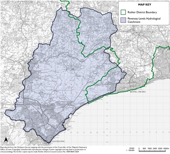
7.52SuDS have various stages of treatment. Guidance from the LLFA states that rainfall should pass through at least two stages of treatment to ensure water quality is improved before being infiltrated or otherwise discharged off site. At least three stages are required within the Pevensey Levels Hydrological Catchment shown in Figure 7.3 below, however, to ensure the protection of this sensitive site. Relevant development within close proximity to the Pevensey Levels and also the Dungeness Complex of Sites will also be subject to Habitats Regulations Assessment under the relevant Regulations.
7.53Applicants should submit sufficient information to enable proper consideration of drainage proposals. For major schemes, seeking pre-application advice from the LLFA is strongly recommended. For minor development, the LLFA’s ‘SuDS Decision Support Tool for Small Scale Development’ should be used. In all developments, attenuation measures such as green roofs, rainwater harvesting and permeable paving, should be incorporated to help to reduce runoff where appropriate. For major development, the Drainage Strategy must incorporate the SuDS Concept Design required by Policy LWL6. The Landscape, Levels and Drainage Strategy required by Policy LWL6 and the Drainage Strategy required by this policy must be prepared in a coordinated manner and may form complementary parts of the same submission.
7.54 Proposed SuDs features should not drain into land affected by contamination or Made Ground to prevent the ingress of pollutants into the underlying soils and groundwater. In locations where Made Ground or land affected by contamination may be present (i.e. historic landfills), the Environment Agency should be consulted to ensure that no proposed drainage will cause pollution to controlled waters. In addition, at Fairlight Cove, issues of groundwater affect land stability and cliff erosion, meaning soakaways must be restricted near the cliff face.
7.55Proposals must explain how flood risk impacts will be managed during the construction phase and will need to demonstrate that maintenance measures will be in place for the lifetime of the development.[145] This may be secured by a legal agreement.
Policy ENV4: Foul Water Drainage Comment
|
Status |
Non-strategic |
|
Priorities |
Green to the Core |
|
Strategic Objectives |
1, 3 |
|
|
|
Key evidence and/or guidance
|
|
7.56The Government’s planning advice on the use of non-mains foul drainage in England is contained within the Planning Practice Guidance (PPG). Both the PPG and the Building Regulations 2010 Approved Document H set out a presumption in favour of connection to the public foul sewer wherever it is reasonable to do so.
7.57The drainage hierarchy is a sequential approach to the disposal of foul water. This means that development proposals must first consider connection to the public foul sewer network where capacity is available, before considering alternative options where connection is not feasible. Alternative methods are assessed in order of preference, typically including package treatment plants and, only as a last resort, private septic tanks. The hierarchy helps ensure that foul water is managed in a way that protects public health, safeguards water quality and sensitive environmental habitats, minimises pollution risks, and promotes the efficient use of wastewater infrastructure.
7.58Before a proposal to use non-mains foul drainage is considered, an applicant must demonstrate to the Council’s satisfaction that it is not practicable to connect to the public sewer in accordance with Environment Agency guidance on discharge of surface water and groundwater. The cost of the connection will not necessarily be the determining factor, as connection to the sewer may still be reasonable where it is more costly than the installation of a private foul sewerage system because of the environmental benefits of connection to the mains foul sewer. Similarly, capacity or other operating problems with the public sewer, are not acceptable reasons for non-connection where this is otherwise reasonable. Where there is a lack of capacity within the public sewerage system, applicants should establish with the Water Authority how they can connect their development to the existing network without worsening existing issues.
7.59Adopted treatment plants (a sewage treatment plant that is adopted by the local water authority) would be preferable for any site that is within the catchment of the Pevensey Levels. High nutrient loading will exacerbate the problem with the non-native invasive species, pennywort, which is a challenge to manage and is spreading on the Pevensey Levels.
7.60 Where it is proposed to connect to the mains foul sewer, the applicant must identify the closest potential point of connection, in consultation with the Water Authority.
7.61Where a connection to the public sewer is not reasonable, the hierarchy of non-mains alternative solutions set out in Section H1 of Building Regulations Part H[146] must be followed. This occurs most frequently in the rural areas of the district. It is unlikely that any major developments would be permitted to discharge via a non-mains drainage system, given the potential risk to the environment. The Council will apply the Environment Agency’s advice for local authorities on non-mains drainage from non-major development in the decision-making process. Applicants should provide evidence that the Environment Agency’s General Binding Rules has been considered, and where compliance is not possible, that application for the relevant permits has been submitted.
Policy ENV5: Ground Conditions Comment
|
Status: |
Non-strategic |
|
Priorities |
Green to the Core |
|
Strategic Objectives |
1, 3 |
|
|
|
Key evidence and/or guidance
|
|
7.62Challenging ground conditions can be caused by many factors. This policy relates to ground condition issues caused by both instability, and land contamination.
Land Instability
7.63Rother’s coastline is vulnerable due to erosion and more extreme events linked with climate change, in addition, local ground conditions, flood events and former land filling or mining can also cause stability issues.
7.64 The NPPF requires planning authorities to prevent development from contributing to land instability or being adversely affected by it. At the same time, it recognises that carefully planned development can provide opportunities to remediate unstable land and reduce existing risks through appropriate mitigation and restoration measures. In addition, the NPPF requires developers and landowners to ensure that development is safe and fit for purpose. Proposals should also consider the likely effects of climate change. Comprehensive site investigations should be undertaken prior to submission to provide an evidence base for decision-making.
7.65As a starting point, development should avoid unstable land through the design and layout of the proposal. It is recognised that this may not always be possible and as such, development on unstable land should be designed to be safe.
7.66Developers may be required to demonstrate that they have investigated risks and where there is likelihood of instability, a full land instability risk assessment report must be submitted with a planning application. This must be undertaken by a competent person to demonstrate the degree of instability, appropriate measures to mitigate those risks, an implementation plan, and future monitoring plan. Further information on the steps developers should take are contained within the Planning Practice Guidance on Land Stability.[147]
Land Contamination
7.67The planning system plays a complimentary role with dealing with land contamination alongside a range of other systems and legislative requirements. This means that planning policies should be contributing to an enhanced environment and safe for the new use. National planning policy and guidance expand further on the considerations required when dealing with land contamination and remediation. Responsibility for securing a safe development rests with the developer and/or landowner. However, the Council should be satisfied that a proposed development will be appropriate for its location and not pose an unacceptable risk.
7.68Previously developed land (or brownfield land) has the potential to be impacted by historical contamination, and this should be fully investigated at an early stage of any development proposal. Developments involving ground works on or in the vicinity of sites where contamination is known or suspected will also require investigation. In Rother, this can commonly include, but not be limited to, proposals involving the conversion of former agricultural buildings. Any investigation and assessments must be carried out by a suitable qualified person. This will likely be a person accredited by the National Quality Mark Scheme (NQMS) for Land Contamination Management.
Policy ENV6: Rother Coastal Change Management Area Comment
|
Policy Status |
Strategic |
|
Overall Priorities |
Green to the Core, Live Well Locally, Thriving Local Economy |
|
Strategic Objectives |
1, 3 |
|
|
|
Key evidence and/or guidance
|
|
7.69The Rother coastline shares coastal boundaries with Hastings Borough, Wealden District (to the west) and Folkestone & Hythe District (to the east). Whilst this Local Plan addresses the section of coastline within Rother District, coastal processes operate across administrative boundaries and can have cross-boundary implications. Accordingly, the effective management of coastal change requires ongoing cooperation and a coordinated approach between adjoining local planning authorities and other stakeholders.
7.70Rother’s coastline presents two main coastal typologies; low-lying areas, and cliff top areas. Both are comprised of a variety of soft silts, clay, sand, gravel and other material that is susceptible to erosion and significant movement over time. The natural process of erosion and movement of material has taken place over thousands of years and will continue to shape the coastline. Various schemes of soft and hard defences including groynes, beach replenishment and sea walls have been used to protect settlements along the coast such as Bexhill, Fairlight, Pett Level, Winchelsea Beach, Rye Harbour and Camber.
7.71National planning policy and guidance state that local plans should reduce the risk from coastal change by avoiding inappropriate development in vulnerable areas and not exacerbating the impacts of physical changes to the coast. It further states that Plans should identify Coastal Change Management Areas (CCMA) which cover areas likely to be affected by physical changes to the coast over both short and long-term time periods.
7.72Shoreline Management Plans (SMP) set out the strategic high-level policies for the coast, and determine appropriate, strategic policies for coastal management that balance the many, and often competing, aspirations of stakeholders with proper regard for economic and environmental sustainability. The SMP divides the coastline into individually numbered, discrete lengths, which are accordingly designated management strategies in the short (0-20 years), medium (20-50 years) and long term (50-100 years). These strategies are comprised of ‘Hold/advance the line’, ‘Managed realignment’ and ‘No active intervention’. The overarching aim of the SMP is to move towards a more sustainable naturally functioning coast. The National Flood and Coastal Erosion Risk Management Strategy for England (NFCERMS) compliments the SMPs and sets out a comprehensive long-term vision and strategic framework for managing flood and coastal erosion risks across England. NFCERMS has a clear vision, “A nation ready for, and resilient to, flooding and coastal change – today, tomorrow and to the year 2100" and outlines long-term goals supported by evidence on future flood risks and investment requirements.
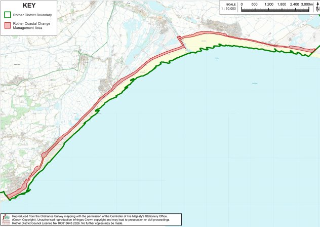
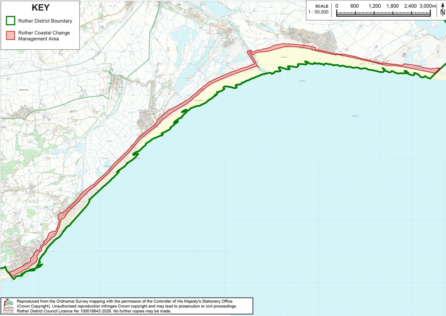
7.73The Local Plan designates a CCMA along the entire Rother coastline, incorporating SMP policy units 4C14 to 4C22 and 4C26 to 4C27, as identified in Figure 7.4 and Figure 7.5. Whilst parts of units 4C14 and 4C27 lie within the administrative areas of Folkestone & Hythe District Council and Wealden District Council respectively, a consistent cross-boundary approach has been adopted where possible. This reflects the approach taken by neighbouring coastal authorities and accords with the recommendations of the Rother Strategic Flood Risk Assessment (2026), which is informed by the SMP, National Coastal Erosion Risk Mapping 2 (NCERM2), and supporting evidence on coastal change and erosion risk[149].
7.74All planning applications for development within the CCMA must be accompanied by a Coastal Vulnerability Assessment (CVA) and account for the potential risk of erosion upon the development. The requirements of a CVA are set out in PPG. The assessment should be appropriate to the degree of risk and the scale, nature and location of the development and the policy will be applied proportionately according to the level of risk to its objectives. The SMP evidence currently provides the best available information on the anticipated impacts of future coastal erosion and should be used to inform assessments of properties at risk. Exceptions may apply where a CVA submitted by the applicant demonstrates, through robust and up-to-date site-specific evidence, that an alternative assessment is justified. It should also be noted that the relevant SMPs and associated erosion mapping are expected to be updated over the course of the Local Plan period.
7.75The CVA should demonstrate that the development provides wider sustainability benefits that outweigh the predicted coastal change impact; will be safe through its planned lifetime, without increasing risk to life or property, or requiring new or improved coastal defences; does not affect the natural balance and stability of the coastline or exacerbate the rate of change (beyond the policies of the relevant SMP) and should consider and identify measures for managing the development at the end of its planned life.
7.76The Council acknowledges that coastal communities may have been adversely affected by coastal change, resulting in reduced property values and investment. There is therefore a recognised need for an approach to coastal management that allows natural processes to occur while ensuring that coastal communities remain sustainable, economically resilient, and attractive places to live, work, and visit. Therefore, during the medium and long-term period (21 to 100 years), time-limited development related to the coastal strip, including hotels, retail premises, offices and leisure facilities, may be permitted where it can be demonstrated that the development will be safe throughout its anticipated lifespan, can be effectively remediated and restored upon the expiry of planning permission, and will not give rise to unintended harmful effects on coastal change, while delivering economic and social benefits to the local community.
Habitats and Species
Policy ENV7: Biodiversity Comment
|
Status |
Strategic |
|
Priorities |
Green to the Core, Live Well Locally |
|
Strategic Objectives |
1, 3, 9 |
|
|
|
Key evidence and/or guidance
|
|
7.77The purpose of this policy is to provide a positive strategic framework to help facilitate nature recovery across the district. Rother contains a rich and varied ecological network, comprising international, national and locally designated sites, irreplaceable habitats, priority habitats, wildlife corridors and the stepping-stones that connect them. The Local Plan presents a key opportunity to deliver enhancement and protection of the biodiversity within the district.
7.78Biodiversity net gains and contributions to ecological networks will be sought for all relevant development, proportionate to the scale of the proposal and any potential impacts, in accordance with Policy ENV10 (Biodiversity Net Gain). Measures could include, for example, the protection and enhancement of features such as trees, hedgerows, ponds, meadows and grassland, and woodland, and the provision of additional habitats and landscaping within sites and along boundaries which can provide feeding and nesting opportunities as well as acting as habitat corridors.
7.79Opportunities to enhance sensitive connections to the natural environment will be explored as part of development proposals. Consideration must be given to the fact that additional public access to designated sites has the potential to affect their integrity through recreational disturbance and other impacts. Policy ENV11 (Sustainable Access & Recreation Management Strategy) addresses this issue for the Dungeness Complex of Habitats Sites. In all areas, proposals should refer to the Rother Green and Blue Infrastructure Study to focus access improvements on identified areas, in accordance with Policy ENV13 (Green and Blue Infrastructure).
7.80Where there is a reasonable likelihood that a protected species may be present and affected by a proposal, comprehensive surveys will need to be undertaken by a suitably qualified ecologist to provide the evidence needed to allow a determination to be made on likely impacts, and licenses to be sought where necessary.
Policy ENV8: Habitats & Species Comment
|
Status |
Strategic |
|
Priorities |
Green to the Core |
|
Strategic Objectives |
1, 3, 9 |
|
|
|
Key evidence and/or guidance
|
|
Habitats Sites and Ecological Features in Rother
7.81The habitats and species in Rother are substantial and wide-ranging. There are large areas of internationally and nationally designated sites which, in total, cover approximately 9% of the district, together with many locally designated sites. Additionally, ancient woodland, which covers 16% of the district (the highest percentage in the South-East) has complex and rare biodiversity because of its undisturbed soil, ground flora and fungi. Many nationally defined[151] Habitats and Species of Principal Importance, referred to herein as Priority Habitats and Species, are also represented. These are often found beyond the designated sites.
7.82The East Sussex and Brighton and Hove Local Nature Recovery Strategy (LNRS) maps Areas of Particular Importance for Biodiversity (APIBs) and Areas that Could Become of Importance for Biodiversity (ACIBs). This is further detailed at Policy ENV9 (Local Nature Recovery Strategy).
7.83There are two areas of internationally important wildlife sites extending into the district. The Pevensey Levels, to the south-west, is designated as a Ramsar site of international importance as a wetland habitat and as a Special Area of Conservation (SAC), comprising grazing marsh, wet grassland, ditches and freshwater wetlands. It is considered one of the most important wetland habitats in the region. The Pevensey Levels National Nature Reserve (NNR) also includes land within Rother. At the other (eastern) end of the district and extending into Folkestone and Hythe district, is the Dungeness Complex of Habitats Sites[152]which are designated for their value for birds, rare species and as wetland habitats. Policy ENV11 (Sustainable Access & Recreation Management Strategy) specifically addresses recreational impacts on the Dungeness complex.
7.84 There are many Sites of Special Scientific Interest (SSSI) within the district, protected for their wildlife and natural features. In addition, the High Weald National Landscape (HWNL), which covers some 83% of Rother, is designated for the purpose of conserving and enhancing landscape and scenic beauty, with the conservation and enhancement of wildlife and cultural heritage being important considerations. Some of the key High Weald character features are also designated as Priority Habitats (gill woodland, sandstone outcrops, ancient woodland, heathland, wildflower meadows and ponds). Therefore, consideration should be given to improvements in biodiversity that meet High Weald National Landscape objectives.
7.85Locally designated sites are identified and selected locally using agreed criteria. There are some 60 Local Wildlife Sites in Rother, together with Local Nature Reserves and Local Geological Sites. These sites have an important role within the district’s ecological network. These sites of local biodiversity value and the array of multi-functional green spaces that make up the ‘Green Infrastructure’ of the district provide recreational opportunities, flood management, climate change mitigation and ‘green’ corridors, as well as nature conservation. Regard should be had to Natural England’s Green Infrastructure Framework and Policy ENV1 (Green & Blue Infrastructure).
7.86Ancient woodland and ancient and veteran trees, and also fens, are considered irreplaceable habitat as per national planning policy. Proposals which could affect ancient woodland and ancient and veteran trees must also align with Policy LAN3 (Trees, Woodlands and Hedgerows) and the associated buffers and requirements set out in that policy. Larger buffer zones are more likely to be needed where the surrounding area is less densely wooded; where it is close to residential areas; and where it is steeply sloped. Assessment could also show that impacts – for example the effect of air pollution – are likely to extend beyond this distance. Ancient and veteran trees should be retained in situ and allowed to decay naturally unless it can be demonstrated this is not possible due to unacceptable risks to health and safety.
7.87Hedgerows are also of considerable biodiversity importance, providing valuable habitat and ecological connections, and are protected. In rural areas, especially within the HWNL, hedgerows often form important enclosures as historic field boundaries, taking account of the well-preserved medieval characteristics present within the HWNL. As such, development will also need to demonstrate that hedgerows are protected and enhanced where necessary.
Protected and Important Species in Rother
7.88 Natural England provides guidance regarding construction near protected areas and wildlife whilst protecting species[153]. This guidance covers both European Protected Species and other species protected through the Wildlife and Countryside Act 1981 (as amended). The most commonly occurring in Rother include great crested newts, bats and dormouse. Other protected species that can be found in Sussex include badgers, water vole, common lizard, grass snake, slow worm and Roman snail.
7.89Rother District Council holds a Great Crested Newt Organisational (or ‘District’) Licence granted by Natural England. The associated District Licensing Scheme, which is currently administered and managed by NatureSpace Partnership, provides an alternative licensing option for developers to address impacts on protected great crested newts by enabling a ‘conservation payment’ towards high-quality habitat creation and long-term management and monitoring. It is based on a great crested newt landscape-scale conservation strategy, which aims to focus the creation of new habitats where they will be of maximum benefit to the species, whilst also reducing risk and uncertainty through the planning process for developers and planning authorities. The strategy results in a range of other biodiversity benefits and contributes towards nature recovery at the landscape scale.
7.90There are a wide range of Priority Habitats and Species present in Rother. The habitats and species contained on the list are conservation priorities and are used to guide the Council in implementing their statutory duty to have regard to the conservation of biodiversity when carrying out their normal functions. Priority Habitats within Rother include woodland, maritime cliff and slopes, hedgerows and lowland meadows, and Priority Species include hedgehog, common toad, house sparrow, brown-banded carder bee and pennyroyal.
7.91 In addition to mandatory biodiversity net gain - see Policy ENV10 (Biodiversity Net Gain) - development proposals have the potential to benefit local biodiversity through the inclusion of integrated bird, bat and bee boxes and bricks. Built-in bricks (for swifts for example) are preferred as they are integrated into the building, cannot be removed and require less maintenance. Developments are expected to follow best practice guidance BS42021: 2022 in providing bird boxes at a ratio of one per dwelling. Hedgehog highways should also be created, through the provision of holes in garden walls and fences. Such interventions should be targeted where specific species can benefit most, as informed by ecological surveys and the Local Nature Recovery Strategy.
Policy ENV9: Local Nature Recovery Strategy Comment
|
Status |
Strategic |
|
Priorities |
Green to the Core, Live Well Locally |
|
Strategic Objectives |
1, 3 |
|
|
|
Key evidence and/or guidance
|
|
7.92Local Nature Recovery Strategies set out areas of current importance for biodiversity, and areas that could be important for biodiversity where nature could be both created and restored, along with measures for nature recovery. For many decades nature conservation in England has been founded in large part upon the identification and protection of key areas of habitat deemed our most important for nature conservation. At the core of this effort has been the notification of Sites of Special Scientific Interest, covering more than a million hectares or over eight per cent of England. Many are further protected through additional legal safeguards operated under European Union Directives.
7.93The application of controls to protect this network of key areas is vital in safeguarding many of our best wildlife and geological areas this policy sets these criteria in this plan. However, evidence[154] has shown that this is not enough to see nature thrive and to meet the needs of society.
7.94The Environment Act 2021[155] places a duty on local authorities to have regard to its Local Nature Recovery Strategy – to create more, bigger, better and connected areas of wildlife-rich habitat benefiting nature and people. In Rother District, this is the East Sussex and Brighton & Hove Local Nature Recovery Strategy (LNRS)[156].
7.95The Government’s ambition is that Local Nature Recovery Strategies will become the new focal point for a broad range of land-use and management activities, and in so doing deliver a step-change in the effectiveness of the action taken for nature recovery and associated environmental improvement.
7.96The East Sussex and Brighton & Hove LNRS was published in 2026. It includes 24 locally agreed priorities for the key habitats in the area, supported by 106 achievable actions (or measures). There are priorities and measures relevant to both rural and urban locations.
7.97The LNRS includes mapping which identifies “Areas of Particular Importance for Biodiversity” (APIBs), defined as designated sites and areas of irreplaceable habitat, and “Areas that Could become of Importance for Biodiversity” (ACIBs). ACIBs are areas where it is proposed that effort should be concentrated to restore habitat, to achieve the most for biodiversity and the wider environment and achieve greater connectivity of similar biodiverse habitats across the landscape. Under the Environment Act, Local Planning Authorities must be aware of those areas mapped and identified in the relevant LNRS and the measures proposed in them. In planning decisions, the LNRS is an evidence base which contains information that may be a material consideration in the planning system.
7.98Development proposals which align with and support the delivery of measures identified in the LNRS will be supported. Developers should use the LNRS to help inform the creation of biodiversity-rich developments that deliver multiple benefits for nature and people, and to refer to when planning habitat creation as part of development through Biodiversity Net Gain. Proposals should show that they have explored opportunities to better understand the location of development in relation to its wider environment and reflect this in the design and delivery of biodiversity on site.
Policy ENV10: Biodiversity Net Gain Comment
|
Status |
Non-strategic |
|
Priorities |
Green to the Core |
|
Strategic Objectives |
3 |
|
|
|
Key evidence and/or guidance
|
|
7.99The Government has produced guidance on the statutory requirements for Biodiversity net gain[157]. Development has an important role in contributing to nature recovery. The purpose of this policy is to ensure biodiversity net gain is achieved through development to help protect and enhance the natural environment, which in turn, will support the long-term adaptability and resilience to climate change across the district.
7.100The approach supports and reinforces other policies throughout this Local Plan and should be used in conjunction with that set out in Policies ENV7 (Biodiversity) and ENV8 (Habitats & Species).
7.101An assessment of the existing biodiversity value of the onsite habitat of the development site (the pre-development value) will be required at the point that planning permission is applied for. In order to establish the pre-development value, consideration will be given to whether any deliberate harm to the biodiversity value has taken place in the recent past. Where there is evidence of deliberate neglect and/or damage, or the relevant date has not been subsequently agreed with the Council, the pre-development biodiversity value of the onsite habitat will be taken as that directed in the Environment Act[158].
7.102A key element of achieving biodiversity net gain is the correct application of the mitigation hierarchy[159] in the initial stages to ensure what is delivered is additional to what is already required through the planning process. Measurable biodiversity net gains will be sought for all qualifying development, and at the very least in accordance with the minimum requirements of the policy and proportionate to the scale of the proposal and any potential impacts and any subsequent mandatory targets.
7.103The Biodiversity Gain Hierarchy[160] sets out the priority of retention of onsite habitats of medium or higher distinctiveness and the enhancement and creation of new habitat on site in favour of the loss of on-site gains. Development and biodiversity net gain proposals will be required to demonstrate the consideration and feasibility of each stage rather than assume provision can be accommodated off-site through compensation at the outset.
7.104In following the mitigation hierarchy and biodiversity gain hierarchy, loss of habitats on sites is avoided. If it is demonstrated that it is not possible to avoid, mitigate and compensate all impacts on site, then compensatory habitat creation should be obtained firstly through a combination of on-site and local third-party schemes, then local third-party schemes only, and lastly through any statutory credit scheme. Off-site provision should be informed by and support wider policy objectives and those of the East Sussex and Brighton & Hove Local Nature Recovery Strategy.
Policy ENV11: Sustainable Access & Recreation Management Strategy Comment
|
Status |
Non-strategic |
|
Priorities |
Green to the Core, Live Well Locally, Thriving Local Economy |
|
Strategic Objectives |
3, 4 |
|
|
|
Key evidence and/or guidance
|
|
7.105Rother includes areas and sites that are protected for their environmental and ecological importance. Many of these provide benefits to local communities and visitors with opportunities for leisure and recreation. However, as part of the successful management of these areas and sites, there is sometimes a need to proactively protect them from disturbance and overuse.
7.106The potential impact of tourism and recreation on the Dungeness Complex of Habitats Sites was an issue first highlighted through the Habitat Regulations Assessment of the Rother Core Strategy. Therefore, the Council, in partnership with Folkstone & Hythe District Council and with advice from Natural England, prepared a Sustainable Access and Recreation Management Strategy (SARMS) (2017) for the area. The SARMS provides a strategic, cross-boundary approach to managing recreational pressure and disturbance, both in relation to additional usage resulting from development and more generally to ensure sensitive management of the habitats. It identifies a need to raise the profile of the nature conservation value of the strategy area in a way that will also benefit the visitor economy, to improve visitor education and, in some areas, change behaviour to support protected habitats and species.
7.107The SARMS now needs to be updated, including the undertaking of new visitor surveys (over a 12-month period) to determine the area from which visitors who may be impacting on the habitats travel. This will inform the necessary mitigation measures to be set out within the strategy. The Council is proactively working with Folkestone and Hythe District Council and Natural England to agree the scope of and commence the update. Policy ENV11 provides the policy basis by which to require implementation of the revised strategy, once this is available; an approach that has been agreed with Natural England.
7.108In the meantime, proposals which could result in an increase in recreational impacts to the Dungeness Complex of Habitats Sites will need careful consideration and assessment under the Habitats Regulations to ensure no adverse effects, and where necessary, mitigation measures will need to be secured as part of the planning permission. Until the new SARMS is completed, the existing SARMS (2017) will be used to inform appropriate mitigation, also in consultation with Natural England.
Policy ENV12: Bewl Water Comment
|
Status |
Non-strategic |
|
Priorities |
Green to the Core, Live Well Locally, Thriving Local Economy |
|
Strategic Objectives |
1, 3 |
|
|
|
Key evidence and/or guidance
|
|
7.109The policy recognises and protects the special landscape, ecological and environmental qualities of Bewl Water, as well as to support appropriate recreational uses, consistent with other policies in Chapter 7 and the Local Plan.
7.110Bewl Water Reservoir is situated at the northern edge of the district and straddles the boundaries with the adjacent authorities of Tunbridge Wells and Wealden. With an area of some 310 hectares and maximum capacity of 31,000 megalitres, it is an important regional water resource and the largest inland water body in the southeast. It lies wholly within the High Weald National Landscape.
7.111The reservoir was dammed in the mid-1970s and featured the design of landscape architect Dame Sylvia Crowe. The 2016 East Sussex County Landscape Assessment describes Bewl Water as being formed from the upper tributaries of the Bewl River, situated within a landscape characterised by gentle spurs, stream valleys, steep wooded ghylls, ancient woodlands and historic farmsteads.
7.112The reservoir is a highly significant area for wildlife, confirmed by its designation as a Local Wildlife Site. The area’s wetland habitat, tranquillity and dark skies mean that it is an important site for a wide variety of bird species including water fowl and migrating birds in the spring and autumn. More specifically, Bewl Water is also a notable habitat for the Common Gull and Black-Headed Gull, of which there are very large populations during wintering months.
7.113The reservoir is also a significant recreational amenity, drawing upon a wide catchment area, that makes an important contribution to local health and wellbeing. It offers recreational activities including walking, cycling, rowing, sailing and fishing. Established water sports clubs, facilities and associated infrastructure play an important role in enabling public participation in recreation at Bewl Water. The long-term retention and improvement of such facilities will be supported where consistent with the area's landscape and ecological sensitivities, and the criteria of this policy.
7.114 Development pressures, including from tourist-related development at Bewl Water have the potential to impact on its landscape, tranquillity, dark skies, and biodiversity. Careful consideration must therefore be given to such proposals. This will ensure that Bewl Water can continue to function as an open space for quiet, low-impact daytime recreation connected to its natural features.
7.115As Bewl Water extends across three local authority boundaries, the Council will continue to work constructively with neighbouring authorities, statutory bodies and other stakeholders to promote a coordinated approach to the protection, management and enjoyment of the reservoir and its setting.
7.116No specific boundary for the setting of Bewl Water is shown on the Policies Map. This is deliberate, as the extent of the reservoir's setting may vary according to the particular development proposal and the characteristics being considered. The application of this policy will therefore be considered on a case-by-case, considering the location, nature and scale of development.
Green & Blue Infrastructure & Rights of Way
Policy ENV13: Green & Blue Infrastructure Comment
|
Status |
Strategic |
|
Priorities |
Live Well Locally, Green to the Core, Thriving Local Economy |
|
Strategic Objectives |
1, 3, 4, 9 |
Safeguarding existing green and blue infrastructure
Enhancement and new provision
Quality and design of new GBI
Consideration of blue infrastructure
Management
|
|
|
Key evidence and/or guidance:
|
|
7.117The NPPF is clear that plans should take a strategic approach to maintaining and enhancing GBI networks, plan for the provision of open spaces, integrate green infrastructure to promote healthy lives, mitigate climate change, and secure biodiversity enhancements. This policy addresses these national requirements by setting out a comprehensive approach to the district's natural networks.
7.118For the purposes of this plan, Green and Blue Infrastructure (GBI) refers to a network of multi-functional green spaces (such as parks, woodlands, allotments, and green roofs) and blue spaces (such as rivers, coastlines, and other water bodies) that deliver a wide range of environmental, economic, health, and social benefits. Open Space, which is subject to Policy ENV14, comprises GBI, but GBI also covers a wider range of spaces, not all of which are subject to the standards set out in Policy ENV14.
7.119GBI plays a key role in boosting the vitality of communities and has a direct positive impact on their physical and mental health and wellbeing. Access to a greener environment is associated with better mental health and wellbeing outcomes, and greenspace can help bind communities together. These spaces can also help address the growing issues of climate change, particularly by providing shade and cooling to the users in an otherwise warming environment, reducing water run-off, and storing carbon. GBI is therefore crucial to the success of this Local Plan’s Green to the Core and Live Well Locally overall priorities.
7.120These spaces should be designed to support comfort, social interaction, health and wellbeing. This may include the provision of seating, shade through planting or other design measures and, where appropriate, access to drinking water, particularly in areas intended for longer stays or higher levels of activity.
7.121Opportunities for food growing, such as allotments and community gardens, should be incorporated into green and blue infrastructure networks where appropriate, contributing to health, wellbeing and community cohesion.
7.122This policy aims to ensure that Rother’s network of GBI will be protected, enhanced and managed to provide a multi-functional, high-quality open space resource, capable of delivering opportunities for recreation, health and wellbeing, ecological connectivity, biodiversity net-gain as well as wider ecosystem services for climate change adaptation.
Safeguarding existing green and blue infrastructure
7.123The NPPF places strong protections on existing open space, sports, and recreational land. This policy ensures that existing GBI is safeguarded from development. Loss will only be permitted in exceptional circumstances where the strict, criteria-based tests set out in the NPPF are met, such as the land being proven surplus to requirements, or replaced by equivalent or better provision.
Enhancement and new provision
7.124The Council actively supports development that connects to the wider GBI network, addresses identified local deficits, and improves public access, provided this is balanced with protecting sensitive nature conservation sites from recreational disturbance. Additionally, relevant development proposals will be expected to enhance or restore existing GBI provision and create new provision on-site that connects to the wider GBI network, particularly in localities where qualitative or quantitative deficits are identified. This is in addition to meeting the Open Space standards (where relevant) set out in Policy ENV14. This policy will be applied proportionately according to the scale, nature, and location of the proposed development. The provision of new on-site GBI will not usually be required for householder applications, minor changes of use, or small, constrained sites where physical opportunities for on-site provision do not exist.
7.125Green and blue infrastructure should form a connected and accessible network of spaces within and beyond development sites. This may include public squares, green corridors and routes that provide convenient and inclusive connections into, through and between developments, linking to the wider green and blue infrastructure network.
Design of new GBI
7.126GBI must be treated as integral to the design of new development, not as an afterthought. Policies LWL5 and LWL6 set out how existing site features and green and blue infrastructure should inform the design, capacity and layout of development. Existing GBI assets should be identified early and used, where appropriate, to structure buildings, streets, movement routes, open spaces and landscape provision as part of an integrated design response. Integrating multi-functional GBI of varying scales (from street trees to green roofs) is essential to achieving statutory Biodiversity Net Gain (BNG) and should align with the principles of Natural England’s Green Infrastructure Framework.
7.127 To ensure strategic delivery, major developments (two hectares or more, or 50+ dwellings) must produce a comprehensive GBI Plan. The GBI Plan should be prepared as an integral part of the site masterplanning and design process and coordinated with the design, landscape and drainage information required by Policies LWL5 and LWL6. Where Policy LWL5 requires the principles of Building with Nature to be applied, the GBI Plan should demonstrate how those principles have informed the design, delivery and long-term management of GBI. The GBI Masterplan may form part of wider masterplanning or landscape information provided that the requirements of this policy are clearly addressed.
7.128Applicants should refer to the Rother Green and Blue Infrastructure Study (2026) which provides guidance and relevant mapping of opportunities and deficits to inform proposals and meet this policy requirement.
Blue infrastructure
7.129Some of Rother’s key recreational facilities come in the form of its waters, including the coast, and Bewl Water - further addressed in Policy ENV12 (Bewl Water) - which crosses into both Tunbridge Wells Borough Council and Wealden District Council. Rother’s water assets play a multi-functional role supporting a vibrant array of water-based recreation activities, including sailing clubs, yachting, rowing, and paddle sports along the coastline and inland water bodies, while acting as major tourist attractions and delivering positive impacts on health and wellbeing. However, the growth and management of these water-based activities need to be balanced with a need to protect the environment, particularly where these overlap with or adjoin statutorily protected sites. Because water bodies frequently cross administrative boundaries, development affecting shared blue infrastructure must demonstrate a sensitive, coordinated approach, often requiring a cross-border management plan.
Management and maintenance
7.130For GBI to successfully deliver its intended benefits over time, it must be properly maintained. Furthermore, all developments incorporating GBI must demonstrate that viable, long-term funding and management arrangements are in place before permission is granted, which the Council will secure via planning conditions or Section 106 legal agreements. Where a Stewardship Plan is required by Policy LWL5, the management, maintenance, funding and governance arrangements required by this policy may be incorporated within that plan, provided that the requirements of both policies are clearly addressed.
Policy ENV14: Recreational Facilities & Open Space Comment
|
Status |
Non-strategic |
|||||||||||||||||||||||||||||||||||||||||||||||||||||||||||||||||||||||||
|
Priorities |
Green to the Core, Live Well Locally, Thriving Local Economy |
|||||||||||||||||||||||||||||||||||||||||||||||||||||||||||||||||||||||||
|
Strategic Objectives |
4, 8, 9 |
|||||||||||||||||||||||||||||||||||||||||||||||||||||||||||||||||||||||||
|
Amount and type of provision
Off-site provision
Design of recreational and sports facilities and open space
Open Space Standards
Accessibility Catchment Standards |
||||||||||||||||||||||||||||||||||||||||||||||||||||||||||||||||||||||||||
|
Key evidence and/or guidance
|
||||||||||||||||||||||||||||||||||||||||||||||||||||||||||||||||||||||||||
7.131The NPPF requires planning policies to ensure access to a network of high-quality open spaces and opportunities for sport and physical activity, insists that policies are based on robust, up-to-date assessments of need, and protects existing spaces from development.
7.132This policy translates those national requirements into local action, directly supporting the Local Plan’s overall priorities. It delivers on Live Well Locally by ensuring new and existing residents have immediate access to high-quality spaces for physical health, mental wellbeing, and social interaction. Simultaneously, it delivers on Green to the Core by mandating that these spaces perform critical environmental functions, such as climate adaptation and biodiversity enhancement.
Quantum, Type and Accessibility of Provision
7.133The demand for open space generated by new development must be met. The amount, type and accessibility of space required is supported by the Council’s up-to-date evidence base, including the Hasting and Rother Playing Pitch and Built Facilities Strategy, the Green and Blue Infrastructure Framework Study, and the Local Plan Viability Assessment. Meeting open space needs requires spaces to be within realistic, safe, and convenient walking distances of people’s home. The accessibility catchments set out in the policy are based on Natural England’s Accessible Greenspace Standards and the Rother Green and Blue Infrastructure Study (2026). Accessible greenspace is structured into a size-based hierarchy; residential development will be assessed against this tiered network, ranging from smaller 'doorstep' and 'local' spaces catering for daily recreation close to home, to larger 'neighbourhood' and 'district' spaces. Full definitions and typology descriptions are set out in the Rother GBI Study.
7.134While this policy seeks to maximise open space opportunities across the district, its requirements will be applied proportionately to the scale, nature, and impact of the proposal. Not all types of development are expected to provide open space or financial contributions. Minor schemes—such as householder extensions, small-scale commercial alterations, or changes of use that do not create a net increase in resident population or recreational pressure—will be exempt from these standards. The policy primarily targets new residential developments that result in a net gain in dwellings, as well as major non-residential proposals that attract substantial numbers of new visitors, users, or employees to an area.
Commuted sums
7.135While the Council’s strong preference is for open space to be integrated directly into new developments, commuted sums will be required on constrained or high-density schemes where on-site provision would result in fragmented, unusable strips of land. Similarly, while the "Outdoor sport pitches, courts and greens, tracks and trails" standard (1.60 ha per 1,000 population) applies to developments of 100 or more dwellings, where site constraints or generated demand mean a standalone formal playing pitch cannot practically be accommodated, provision should focus on compact on-site facilities (such as MUGAs, padel/tennis courts, or trim trails) or an off-site financial contribution will be sought.
7.136Where off-site financial contributions towards formal playing pitches and outdoor sports facilities are required under Criterion 3, the Council will refer to Sport England’s Playing Pitch Demand Calculator (PDC) in conjunction with Sport England’s published facility and facility costs. Financial contributions secured through Section 106 agreements will be directed towards deliverable projects and capacity improvements identified in the Hastings and Rother Playing Pitch and Built Facilities Strategy. This Strategy, including its Stage E reviews and any successor strategy, provides the qualitative and strategic evidence base for formal pitch sports across the district. It assesses specific supply, capacity, and demand pressures, providing an up-to-date action plan to direct S106 financial contributions towards; this includes multi-pitch hub upgrades, artificial grass pitches (3G/AGP), drainage, and pavilion improvements.
7.137Provision for children and young people is secured through dedicated standards for informal play provision (from 10+ dwellings) and equipped designated play areas (e.g. LAPs, LEAPs, and NEAPs from 20+ dwellings). These spaces must be thoughtfully integrated into the layout of the development to ensure safe doorstep play opportunities for young families.
Design of recreational facilities and open space
7.138The quality of an open space is just as important as its quantity. Open space and nature should be carefully integrated into development proposals as they help to reinforce a sense of place and local identity. Open spaces must not be treated as an afterthought fitted into undevelopable areas of a site.
7.139Open space and recreational facilities should be designed to be inclusive and welcoming to all users. This includes ensuring that spaces feel safe and accessible for women, girls and other potentially vulnerable groups, and that people of all ages and abilities are able to use them confidently. Careful consideration should be given to visibility, lighting, access, and the relationship between spaces and surrounding development. Design should also support shared use of spaces where appropriate, enabling different age groups and users to interact positively within the same environment.
7.140In addition to aligning with the national Building for a Healthy Life framework and relevant Sport England technical guidance, applicants must address four key design and operational factors set out in the policy:
- Central integration: open spaces should be integrated as prominent, central anchors within a site plan. Layouts should ensure these spaces are well-defined and naturally overlooked by surrounding building frontages. This active surveillance inherently enhances community safety, deters anti-social behaviour, and elevates the spatial character of the neighbourhood;
- Prominence and natural surveillance: Facilities must be located in active, well-used areas with direct overlooking from surrounding active building frontages. This natural surveillance enhances actual and perceived safety, deters anti-social behaviour, and encourages regular community use;
- Ancillary facilities: For destination parks or multi-pitch sports facilities, spaces require physical infrastructure to maximise their utility. Proposals must explicitly plan for well-positioned ancillary installations—including changing rooms, public toilets, waste disposal points, and secure maintenance access gates—without dominating the open landscape or generating noise impacts on nearby properties;
- Materials: Surface materials must be durable and highly legible to satisfy accessibility requirements for all user groups. Mixed colours may appear as hazards or barriers to those with visual conditions; similarly, varied patterns can make pathways less legible, causing disorientation. Generally, the design quality of open (or public) spaces outweighs the quality of materials used. Even basic materials can support a strong design, while expensive materials cannot rescue a poor one.
7.141Public open space provided within a new development should not be designed for the exclusive use of those occupiers but form an extension to the existing network of spaces.
Policy ENV15: Public Rights of Way Comment
|
Status |
Non-strategic |
|
Priorities |
Live Well Locally, Green to the Core |
|
Strategic Objectives |
3, 4, 8, 9 |
|
Protection and integration
Enhancement and new provision
Alterations and diversions
|
|
|
Key evidence and/or guidance:
|
|
7.142 The NPPF expects planning policies to protect and enhance public rights of way and access, including taking opportunities to provide better facilities for users. As a predominately rural district, Rother benefits from over 930km of Public Rights of Way (PRoW) primarily managed by East Sussex County Council. In rural areas, these routes can offer a safer form of connection than would otherwise be had through walking, wheeling or cycling on roads and lanes. Across the District, they are an important asset in our towns and villages in promoting physical activity. These include footpaths and bridleways, twittens, and strategic routes, such as the National Cycle Network 2.
Protection, enhancement and new provision
7.143 PRoWs offer a crucial, safe form of active travel away from roads, promoting physical activity and providing essential access to the countryside. Therefore, development must avoid harming these networks. Where a development includes or borders a PRoW, it must be sensitively integrated. The Council expects PRoWs to remain distinct, green corridors; simply absorbing a rural footpath into a standard paved pavement alongside a new estate road is not an acceptable design approach.
7.144 The Council supports the creation of new PRoW, such as upgrading bridleways to multi-user greenways suitable for active travel through walking, wheeling, cycling, and horse riding, especially where they close gaps in the existing network.
7.145 In practice, an improvement to any network being impacted is expected. Where development is adjacent to a PRoW, the Council would expect that access is provided to this network to enable the users of the new development to access the PRoW and utilise its benefits. East Sussex County Council will be consulted on relevant planning applications affecting PRoW.
7.146 To ensure that enhancements and new routes are targeted effectively, applicants should consult the latest Local Cycling and Walking Infrastructure Plan (LCWIP). The LCWIP serves as a key piece of evidence, identifying structural deficiencies, critical network gaps, and prioritised active travel corridors across the district. Proposals that align with or directly deliver the specific route improvements highlighted within the LCWIP will be supported, as this ensures developer contributions are directed to strategic, well-coordinated networks.
7.147 Where new routes are created or existing paths are upgraded, the physical design must ensure they are safe, resilient, and usable year-round without degrading the character of the landscape. To demonstrate that a new or enhanced route is “appropriately designed having regard to the built, natural, and historic setting”, proposals must satisfy the following principles:
a. Surfacing and drainage: Surface choices should reflect the route's context and expected volume of multi-user traffic. All-weather, permeable surfacing should be used alongside integrated sustainable drainage solutions to prevent waterlogging, muddy tracking, and erosion.
b. Inclusive accessibility: Routes must prioritise step-free access to cater to users of all ages and abilities, including wheelchair users and pushchairs.
c. Sensitive lighting: While artificial lighting may be necessary to ensure personal safety along urban segments or routes connecting to key transport hubs, it must be avoided in open countryside and highly sensitive rural areas. Where lighting is fully justified, it must use low-lux, down-directed, and motion-activated systems to minimise light spill, strictly safeguarding local wildlife corridors and the dark sky environment of the High Weald National Landscape in accordance with Policy LAN3 (Light Pollution & Dark Skies).
7.148 Expanding access to the countryside must be balanced against the need to protect sensitive habitats from increased recreational pressure, which is specifically managed in the eastern part of the district through Policy ENV11 (Sustainable Access & Recreation Management Strategy).
Alterations, historic routeways, and the HWNL
7.149 The Council will not support the loss of or harm to a PRoW. While it is acknowledged that under some circumstances, the diversion or alteration of an existing route is necessary to enable development, this must not result in a downgraded user experience. Any diverted route must be enhanced, providing at minimum a more accessible, safer, or more scenic journey. East Sussex County Council will be consulted on all applications seeking to alter a PRoW.
7.150 Particular care must be taken regarding historic routeways. Many PRoWs in Rother trace ancient paths, drovers' roads, or sunken lanes that hold significant heritage value. Where a PRoW is identified as a historic routeway, its historic alignment and character must be respected. Furthermore, where diversions are proposed within the High Weald NL, the new route must be designed to conserve and enhance the area's statutory landscape protections.
7.151 It is important to emphasise that this policy does not apply to any private or permissive rights of way, as these are in private ownership and can be withdrawn by the landowner at any time. As such, it is not appropriate for the Council to formalise or protect them through this policy.
Policy ENV16: Combe Valley Countryside Park Comment
|
Status |
Strategic |
|
Priorities |
Live Well Locally, Green to the Core |
|
Strategic Objectives |
3, 4 |
|
|
|
Key evidence and or guidance:
|
|
7.152 The NPPF expects planning policies to protect and enhance the natural and local environment and to ensure access to a network of high-quality open spaces to promote health and well-being. In addition, the PPG supports the strategic planning of GBI to deliver multi-functional benefits. This policy formally allocates and protects the Combe Valley Countryside Park (CVCP) to fulfil these national objectives and local priorities (Live Well Locally and Green to the Core), securing a critical piece of strategic GBI for the district.
7.153 The CVCP acts, in part, as a strategic gap between Hastings/St Leonards and Bexhill. It covers an area of approximately 600 hectares which provides access to the countryside and facilitates a range of appropriate recreational activities, while balancing the need to proactively manage wildlife habitats. By safeguarding this space, the policy directly addresses the deficiency in green space for the towns of Hastings and Bexhill.
Management strategy and scale of development
7.154 The Park was jointly established by RDC, HBC and ESCC. In 2015, a Community Interest Company (CIC) was formed with a board of directors including representatives of the three councils, local businesses, landowners and stakeholders, including the Friends of Combe Valley Foundation (a group which was established by local residents). The CIC sets out the long-term vision for the area through the Strategy for the Countryside Park.
7.155 To protect the area's fundamental character, general development within the CVCP will be strictly controlled. Development must be intrinsically linked to the park’s recreational or environmental function (such as essential visitor facilities or conservation infrastructure) and demonstrably deliver the objectives of the CIC's Strategy.
7.156 There are many designated and protected sites within the Countryside Park, covering areas such as biodiversity and archaeology. These cover both the terrestrial and marine environments and due regard must be had to them when determining proposals.
Conservation and relieving recreational pressure
7.157 As the CVCP has become established, it has helped take some of the pressure off the other sensitive leisure destinations in the area and has specifically helped to manage the recreational pressure on more sensitive habitats, most notably the international Habitat Site designations to the south-east and south-west of the district. Maintaining the high quality and usability of the CVCP is therefore essential to facilitate a shift in recreational demand away from highly vulnerable ecological areas.
Adjacent uses
7.158 The Park sits within a complex landscape that encompasses or borders Pebsham Rural Business Centre, Hastings Household Waste Recycling Centre and a Southern Water Wastewater Treatment Centre. While the former land-raise operation for waste management has long ceased, there is continued use of land within the locality for waste collection, in line with the waste planning authorities’ Waste and Minerals Plan. It is important that such operations are contained and do not conflict with the aims and objectives of the Countryside Park.
Pebsham Landfill Site
7.159 There may be an opportunity to use land at the former Pebsham Landfill site for the development of a stand-alone ground mounted solar installation (“a solar farm”). While this land is within the boundary of the CVCP it will not become safe or available for public access for many years, due to the nature of the landfill and the need for it to settle and release gas. However, while it is in this condition it could potentially be suitable for solar development, which itself would have a limited lifespan, and this is allowed for through Policy GTC6 (Renewable & Low-carbon Energy). Due to the current unsuitability of this land for other uses and the temporary nature of a solar farm, this potential use is not considered to conflict with the longer-term allocation of this land as part of the CVCP.
Heritage
Policy HER1: Conservation of the Historic Environment Comment
|
Status |
Strategic |
|
Priorities |
Live Well Locally, Green to the Core, Thriving Local Economy |
|
Strategic Objectives |
3, 4 |
|
|
|
Key evidence and/or guidance:
|
|
7.160National planning policy requires Local Plans to set out a positive strategy for the conservation and enjoyment of the historic environment.
Heritage assets in Rother district
7.161Rother district has a rich heritage environment and a valuable and extensive historic building stock, including as it does the historic market towns of Battle and Rye, the Victorian and Edwardian seaside town of Bexhill-on-Sea, the planned medieval town of Winchelsea, and a host of picturesque villages and hamlets. The historic built environment has a high level of statutory protection; designated heritage assets include approximately 2,200 Listed Buildings, 10 Conservation Areas, a number of Scheduled Ancient Monuments and Registered Parks and Gardens, and the ‘Historic Battlefield’ at Battle. Many other non-designated heritage assets contribute positively to the physical, historic and socio-cultural character of the district.
7.162The historic built environment underpins the distinctive character of the district; through the pattern, form, and appearance of settlements and individual buildings, and the materials of their construction. These contribute to the unique sense of place, cultural identity and local distinctiveness of both the district as a whole, and of each settlement. The landscape setting of individual towns and villages varies from the linear form most usually associated with ridge-top development, to the less common valley setting associated with river crossings. Particularly distinct settlements are the nucleated hill-top setting of the ancient town of Rye, and the formalised medieval grid plan of Winchelsea. Historic farmsteads with farm building typologies representing locally distinctive historic agricultural practices, are prolific within the rural landscape.
7.163Locally distinctive building typologies and features include long sweeping catslide roofs, oast houses, timber-framed barns and other agricultural buildings associated with local historic farming practices, and medieval Wealden Hall Houses, found either as rural farmhouses, or incorporated into the fabric of villages and towns, and often much disguised through later alterations.
7.164Historic buildings in the district generally deploy a limited palette of materials associated with the local High Weald geology, namely timber-framing, clay tiles (for roofs and wall hanging) and brickwork. In specific pockets to the east of the district, white-painted weatherboarding is prolific, and to the west of the district are distinctive groups of buildings constructed from the local Brightling sandstone. These materials, if properly looked after, are inherently sustainable as they are local, durable, resist wear and decay and can be repaired or replaced. Meanwhile, the coastal resort town of Bexhill-on-Sea has a rich heritage of late Victorian and Edwardian villa architecture, imposing in scale and ornate in detailing, which plays an important role in defining the local character and street scene.
7.165The High Weald AONB Management Plan is a statutory document that sets out defining settlement characteristics of the High Weald, which are to be conserved and enhanced in development proposals. The role of the historic environment in the High Weald National Landscape must be considered in all relevant applications within the HWNL and its setting.
7.166Historic England’s Heritage at Risk Register includes several sites in Rother. There may also be other designated and non-designated assets at risk through, for example, neglect, decay or erosion. Proposals which sustain and enhance such assets will be positively considered in accordance with national planning policy and other Plan policies.
Understanding significance
7.167 Planning applications affecting heritage assets will be required to be accompanied by information describing their significance (including that of the setting). It is particularly important that proposals for the conversion of historic buildings are based on a sound and thorough understanding of the building’s significance, including in terms of its history, layout, use, local relevance, fabric and archaeology, this is further covered through Policy HER2. A Heritage Statement will be required for all proposals affecting a designated or non-designated heritage asset.
Archaeology
7.168Rother contains many Archaeological Notification Areas (ANAs), which are areas containing recorded archaeological remains. Other sites outside ANAs may also contain above or below ground archaeology. In any area of archaeological potential (including ANAs), developers will be required to undertake an assessment to determine the significance of any remains and the potential for harm during development. Options for avoidance or mitigation of harm will be required to be considered.
7.169In addition, any proposal affecting a Scheduled Ancient Monument, and all proposals involving major development will require a desk-based heritage impact assessment. This will include information from the East Sussex Historic Environment Record (HER). The HER database maps and describes the county’s known archaeological and historic sites and features. It holds information on a range of sites and features dating from the Palaeolithic period (c.800,000 years ago) up to 20th Century monuments.
Sustainable historic buildings
7.170 “The greenest building is the one that already exists”[161]. The historic buildings of Rother have an important role to play in realising the Local Plan’s Green to the Core priority. Sustainability in building is not just associated with operational energy consumption, but also the embodied energy used in their construction. Research carried out by Historic England has found that sympathetically upgrading and reusing existing buildings can dramatically improve a building’s energy efficiency and make substantial energy savings compared to demolition. However, in accordance with Historic England guidance, a reduction in operational carbon emissions will not in itself justify development where it would cause harm to the heritage asset.
7.171Older buildings have survived because of their durability and adaptability. Continuing to adapt, upgrade, repair and maintain them so they remain useful and viable makes good social, economic and environmental sense. Generally speaking, improving the energy efficiency of historic buildings and those of traditional construction means reducing heat losses wherever possible without damaging their special character or compromising their performance.
7.172Historic England advocate, and provide detailed guidance on, a holistic ‘whole building approach’[162], which aims to meet the combined objectives of increasing energy efficiency and sustaining significance in heritage assets, while avoiding unintended consequences. This approach can help in understanding where energy goes and identifying less harmful options to achieve energy savings.
7.173Low and zero carbon (LZC) technologies, i.e. microgeneration equipment which generates energy from renewable or low carbon sources and emit low or no carbon dioxide emissions, such as Photovoltaics, Solar Water Heating, Heat Pumps, Wind and Turbines, can also be a part of the equation in reducing a building’s carbon footprint. Again, Historic England has produced guidance on a range of LZC technologies and historic buildings. In considering LZC technologies in the historic environment, consideration will need to be given to whether the particular installation would suit the particular building, whether the system can be fitted with no significant adverse impact on the building and its historic fabric, and what the visual impact on the setting of the building or heritage asset would be.
The public realm
7.174Rother district is fortunate to possess a variety of historic public realm features and surface treatments, including the Listed cobbled streets of Rye, brick paving in Winchelsea and Robertsbridge, and raised pavements in Battle. These are important in defining the special character and local distinctiveness of individual settlements. The retention and sensitive repair and, where appropriate, reinstatement of such features is important in maintaining such character. Rye Conservation Society has produced specific guidance for those carrying out repairs to the town’s historic cobbled streets.
7.175The historic public realm is also important in defining local character and sense of place in the rural areas. The historic public realm across the High Weald is identified in the AONB Management Plan as playing an important role in defining the rural landscape character of the NL. Historic features such as milestones, historic fingerpost signs and red telephone kiosks and letterboxes contribute positively to the character of the rural public realm. This is highlighted in the adopted Rother District Public Realm Strategic Framework[163], which, though district-wide, contains specific references to designated Conservation Areas within the district, and much of the content refers to heritage features in the public realm. Historic England has also produced guidance on highway and public realm works in historic places[164].
Policy HER2: Conversion & Re-use of Historic Buildings Comment
|
Status |
Non-strategic |
|
Priorities |
Green to the Core, Live Well Locally |
|
Strategic Objectives |
3, 4 |
|
|
|
Key evidence and/or guidance:
|
|
7.176National planning policy requires Local Plans to set out a positive strategy for the conservation and enjoyment of the historic environment, which takes into account matters including the desirability of sustaining and enhancing the significance of heritage assets, and putting them to viable uses consistent with their conservation.
7.177 In addition to Policy HER1 which is the over-arching heritage policy, this policy sets out additional detail and considerations for proposals involving the conversion, alteration and reuse of historic buildings. Proposals in Rother commonly involve traditional historic farm buildings, however the policy also relates to other types of historic building.
Historic farm buildings
7.178Rother’s countryside has a highly distinctive and important architectural character by way of settlement pattern and building typologies. The historic hamlets and farmsteads of the High Weald create a distinct and picturesque landscape, with the rolling pastureland and small ancient woodlands of the countryside interspersed with the rich clay-tiled roofs of medieval houses, barns and oasts. Building typologies reflect locally distinct historic agricultural practices, for example the distinctive brick roundels of the hop industry’s oast-houses, fine timber-framed barns and modest brick cowsheds and outbuildings.
7.179Traditional historic farm buildings are a vital element in defining the distinctive character of the district’s countryside, as well as being a valuable economic resource. They have cultural and archaeological value, not just in their fabric, but also their location and setting, to help our understanding of the historical development of farming in the district. Traditional historic farm buildings are generally considered to be those dating from pre-1880, though there may be other pre-war buildings, either late Victorian or Edwardian that are of interest in a farmstead or landscape context and may be worthy of retention.
7.180Historic England has analysed the character of rural settlement and farming throughout England, including in the High Weald, within which the majority of the district’s countryside falls, in their Farmstead and Landscape Character Statements.[166]. This highlights the historic small farm sizes, leading to small ‘farmsteads’ of mostly dispersed cluster plans or loose courtyards, and typically consisting of just the farmhouse, one large multi-purpose barn, and perhaps an oasthouse or a small open-fronted outbuilding[167]. These characteristics are also recognised in the High Weald AONB Management Plan, together with the need to protect and preserve the character and setting of historic traditional buildings and built features distinct to the High Weald.
Other historic buildings
7.181Examples of other non-residential historic buildings found in Rother sometimes proposed for conversion and change of use include former churches, former village schools, water pumping stations and former military buildings. These may be found in both rural and urban settings. Where such buildings are currently or were last in community or employment use, proposals for a change of use would also need to comply with the requirements of Policy ECO4 (Retention of Sites of Economic or Community Value).
Conversion for re-use
7.182In accordance with Historic England guidance[168], the priority uses for traditional agricultural buildings are to retain such buildings in continued farming related uses, and secondly to convert for employment uses, including tourism. Where such conversions are not suitable for the particular nature or location of the buildings, or where the applicant has demonstrated that employment or tourism uses are not viable, residential conversions will be considered. In such circumstances, the applicant should demonstrate that every attempt has been made to secure an employment or tourism re-use first.
7.183Similarly, the priority uses for other non-residential historic buildings currently or last in community or employment use are to retain those uses, due to their need in the district, and only where such uses are demonstrated not to be viable or practicable in accordance with Policy ECO4, will residential conversion be considered. Note that Policy ECO4 does not apply to buildings currently or last in agricultural use. Changes of use from other uses will be considered in line with relevant policies of the Plan.
7.184Different uses of a historic building will inevitably have different physical impacts on the building, its setting and legibility; this is also reflected in the hierarchical approach to conversion uses described above. Continued farm use of agricultural buildings, or in use as a workshop or for light industrial activities, are likely to require only limited alterations to building fabric and to the setting of buildings. In contrast, residential use usually brings greater pressure for internal subdivision of spaces, new openings, curtilage division and domestication which can greatly impact on the significance of these farm buildings and their appearance in the landscape.
7.185It is important that in any conversion or re-use proposal, the distinctive character of the building; their farmstead and/or wider landscape or townscape setting, external appearance, internal character and features, be retained. Domestication of the building or its setting by means of inappropriate alterations, new development, access arrangements or boundary treatments should be avoided.
7.186Specific advice in this respect for farm buildings is given in the Historic England publication ‘Adapting Traditional Farm Buildings – Best Practice for Adaptive Reuse’ (2017) and this should be interpreted alongside the specific advice given in the Farmstead Character Statement with regard to local building typologies and features. Of particular importance at a local level is maintaining the internal spatial qualities of timber framed barns, the elevational character of their cart-bay entrances, and the uninterrupted brick walling of oasthouse roundels.
7.187Specific advice for other types of historic buildings include Historic England Advice Note 2: Making Changes to Heritage Assets and Historic Environment Good Practice Advice in Planning 3: The Setting of Heritage Assets.
Protecting and enhancing biodiversity
7.188Historic buildings, particularly those in rural locations, can often be important habitats for wildlife including protected species such as bats, barn owls and other nesting birds. The Historic England document ‘Adapting Traditional Farm Buildings – Best Practice for Adaptive Reuse’ (2017) gives advice on wildlife legislation in this respect. It recommends that an ecological survey should be carried out at project feasibility stage to establish whether there are protected species present. Enhancements to habitats, such as through the provision of nest boxes, sensitive eave and roof design, retention of rough surfaces and use of small openings typical of farm buildings, should be included as part of any development. Where possible, the creation of adjacent supporting habitat for the relevant species could also be helpful.
7.189The East Sussex and Brighton & Hove Local Nature Recovery Strategy identifies a need to provide nesting and roosting boxes or other features to support bats, birds, insects and reptiles in the farmed environment. For birds, rather than providing general bird boxes, the LNRS recommends for both rural and urban locations, the provision of specific types of boxes suited to threatened bird species found at the location (e.g. swift, house sparrow, starling, owl species, etc) and in locations where over-wintering habitat and summer insect-rich forage is present. Swift bricks are considered a universal fix for small cavity-nesting bird species as they will also be used by house sparrows, starlings, great tits, blue tits and occasionally house martins and nuthatches.
Alterations to converted historic buildings
7.190Historic buildings that have already been converted are also vulnerable to inappropriate alteration or development, for example extensions, new openings, garages, sheds and other outbuildings, boundary treatments and hard surfacing, that would have an adverse impact on the intrinsic character of the building itself, or on its setting. For example, even a well-designed extension will usually undermine the form of a barn or oasthouse as an example of a particular building typology.
Policy HER3: Shopfronts, Signage & Advertising Comment
|
Status |
Non-strategic |
|
Priorities |
Live Well Locally |
|
Strategic Objectives |
3 |
|
|
|
Key evidence and/or guidance:
|
|
7.191National planning policy promotes high-quality design for all types of development, recognising that the quality and character of places can be harmed by the poor placement and design of advertisements.
7.192Shopfronts[169], signage and advertisements form an integral part of commercial streets and of town and village centres in the district. They play an important role in helping to create an attractive retail environment and, as such, contribute to economic vitality.
7.193While advertising and signage generally convey important information and are valuable in promoting business activities, they can have a significant impact on the appearance of buildings and areas. Unduly prominent, prolific or poorly designed signage can detract from the character of a building, the townscape or village street scene or of the countryside within which it is located. Furthermore, if uncontrolled, it can lead to roadside clutter and distract drivers.
7.194In order to protect the amenities of an area, it is important that all signs and advertisements, whether on a building or freestanding, are carefully designed and of an appropriate scale, detail, materials and colours.
Shopfronts
7.195 Traditional shopfronts, such as the late Victorian/early Edwardian ones found in the planned shopping streets of Bexhill-on-Sea or those inserted into the medieval buildings of the market towns of Battle and Rye, are important because they provide active frontages and make a positive contribution to the character and appearance of those historic centres. Without careful attention though, it is easy to gradually erode the character of traditional shopfronts and historic street-frontages and to lose or obscure important building features.
7.196Where shops or other commercial premises lie within Conservation Areas or other areas of historic character, it is particularly vital that shopfronts, signage and advertisements are well designed, detailed and relate positively to their surroundings. There should be a general presumption to retain and restore the original fabric and detailing of historic shopfronts, such as stallrisers, cornices and pilasters, windows and decorative tiling. More generally, any new shopfront should relate well to the building and to its overall setting in the street scene, in terms of its proportions, design, relationship to upper storeys, fascia height and width, mullion treatment, materials and colour. Most common issues relate to the introduction of inappropriately deep or stuck-on fascias and internally illuminated signage. Fascia signs are the most common form of advertisement on a building and should be designed to appear as an integral part of it in terms of their positioning, height, size, design and materials.
7.197 Canopies and blinds may be successfully integrated into a traditional shopfront if carefully detailed and not unduly dominant. However, the use of modern materials such as acrylic sheeting, Perspex, aluminium or plastic, is rarely appropriate for traditional shopfronts on historic buildings in a Conservation Area. There is particular concern around the introduction of solid external roller shutters, which can have a “deadening”, inhospitable effect on the street scene. Where security measures are essential, alternatives such as the use of an internal lattice shutter or laminated glass represent more sensitive approaches.
7.198The Council has adopted specific guidance for shopfronts and signage within Bexhill-on-Sea Town Centre Conservation Area[170], in recognition of the special architectural character of the shopping terraces that were constructed within a very short period of time at the end of the 19th century and beginning of the 20th century.
Advertisements
7.199The illumination of all signs and advertisements needs sensitive consideration and to be restrained in their quantity and brightness. Within the town centres of Bexhill, Battle and Rye, some night-time illumination of shops and other commercial premises helps to promote a vibrant and safe evening economy. Elsewhere, the illumination of signs on buildings, including hanging signs, is normally only justified where it relates to late opening premises such as a public house, restaurant, chemist or similar. At the same time, consideration must be given to the amenity of residential properties. Modern projecting, usually illuminated box signs, can be particularly cluttering and discordant features on shopfronts and in the street scene and are very unlikely to be appropriate within Conservation Areas.
7.200In rural areas, the amount and siting of advertisements, especially illuminated signage, need to be strictly controlled, in the interests of maintaining the generally undeveloped landscape character and amenities of the countryside, preventing “clutter”, maintaining highway safety and dark skies. Hence, unless there are exceptional circumstances which justify an alternative approach, any advertisement should be limited to a location close to the premises it serves and be sited and sized so as to not undermine the local and countryside character. The cumulative impact of advertisements on the character of rural areas will also be a consideration.
Policy HER4: Doors, Windows & Roofscapes in Conservation Areas & Listed Buildings Comment
|
Status |
Non-strategic |
|
Priorities |
Live Well Locally |
|
Strategic Objectives |
3, 4 |
|
|
|
Key evidence and/or guidance:
|
|
7.201There are circumstances where planning permission is required to change the doors, windows or roof covering of a listed building or a property in a Conservation Area. The Council receives many applications that involve such proposals. Original timber sliding sash and casement windows, and timber panel doors can contribute greatly to the character and appearance of buildings within a conservation area and so enhance its overall significance. There are many ways in which windows can be improved to achieve better performance. However, sometimes these elements reach the end of their useful life and require replacement. Under these circumstances, the Council will encourage the choice of replacement doors, windows or roof materials that retain the original character of the building.
7.202It is appreciated that energy efficiency is a key concern of householders, including those living within listed buildings, and unlisted buildings in conservation areas. Policy GTC2 (Net Zero Retrofitting) supports proposals which result in considerable improvements to the energy efficiency and reduction of carbon emissions of existing buildings, highlighting the need for development affecting historic buildings or buildings within Conservation Areas to be guided by Historic England advice on climate change and historic building adaptation. In their guidance “Modifying Historic Windows as Part of Retrofitting Energy Saving Measures” (2024) and “Traditional Windows: their care, repair and upgrading” (2017), Historic England sets out five principles for making changes to windows in listed buildings, which they confirm also apply to unlisted buildings in conservation areas. These include: (1) Where historic windows make a positive contribution to the significance of a listed building, they should be retained and repaired where possible. If beyond repair, they should be replaced with accurate copies. (4) Where historic windows have been replaced with ones whose design does not follow historic patterns, these are unlikely to contribute to the significance of listed buildings. Replacing such windows with new windows of a sympathetic historic pattern, whether single glazed or incorporating slim-profile double glazing, may cause no additional harm. It also provides an opportunity to enhance the significance of the building, which is the desired outcome under national policy.
7.203Other specific advice from Historic England for windows, doors and roofs includes: Adapting Historic Buildings for Energy and Carbon Efficiency: Historic England Advice Note 18; Listed Building Consent: Historic England Advice Note 16; The Setting of Heritage Assets: Historic Environment Good Practice Advice in Planning Note 3; Traditional Windows: Their Care, Repair and Upgrading; and Making Changes to Heritage Assets: Historic England Advice Note 2.
[122] East Sussex Landscape Character Assessment (2016)
[123] For the purposes of this policy, whether a proposal is ‘major development’ is a matter for the decision maker, taking into account its nature, scale and setting, and whether it could have a significant adverse impact on the purposes for which the High Weald National Landscape has been designated or defined.
[124] By the Levelling-up and Regeneration Act (2023)
[125] Countryside Commission (2001), in National Landscapes Association Briefing Note on Applying the CRoW Act (2024)
[126] National Landscapes Association Briefing Note on Applying the CRoW Act (2024)
[127] High Weald AONB Management Plan 2024-2029
[128] Rother District Council meeting ,15th September 2025 (Agenda for Council on Monday 15th September 2025, 6.30 pm - Rother District Council)
[129] The Town and Country Planning (Tree Preservation) (England) Regulations 2012 (as amended).
[130] Rother District Council meeting ,15th September 2025 (Agenda for Council on Monday 15th September 2025, 6.30 pm - Rother District Council)
[131] https://www.gov.uk/guidance/ancient-woodland-ancient-trees-and-veteran-trees-advice-for-making-planning-decisions
[132] CPRE’s light pollution and dark skies map (England's Light Pollution and Dark Skies Map)
[133] Planning Technical Advice Note: Dark Skies in the High Weald (2024) (highweald.org/document-library/legislation-and-planning/high-weald-national-landscape-dark-skies-planning-advice-note/?layout=default)
[134] Guidance Note 08/23: Bats and Artificial Lighting at Night (GN08 Bats and Artificial Lighting)
[136] A Main River is a larger river or stream, designated by the Environment Agency.
[137] An Ordinary Watercourse means a watercourse that does not form part of a Main River (Flood and Water Management Act 2010).
[138] In Rother, the IDBs are Pevensey and Cuckmere Water Level Management Board (PCWLMB) and Romney Marshes Internal Drainage Board (RMIDB).
[139] Confirmed Byelaws for Pevensey & Cuckmere Water Level Management Board Byelaws - Water Management Alliance: Water Management Alliance
[140] Rother District Council meeting ,15th September 2025 (Agenda for Council on Monday 15th September 2025, 6.30 pm - Rother District Council)
[141] Rother District Council meeting ,15th September 2025 (Agenda for Council on Monday 15th September 2025, 6.30 pm - Rother District Council)
[142] Retained in domestic law through The Water Environment (Water Framework Directive) (England and Wales) Regulations 2017 (WER) following the UK’s exit from the EU
[143] e.g. Lead Local Flood Authority (LLFA) Guidance v4 March 2019 and 2021 update, RDC Strategic Flood Risk Assessment 2026, Planning Practice Guidance and National Standards for Sustainable Drainage Systems
[144] Made Ground is an area where the pre-existing (natural or artificial) land surface is raised by artificial deposits (British Geological Survey).
[145] Residential development is defined as having a lifetime of at least 100 years. The starting assumption for non-residential development is 75 years.
[148] Residential development is defined as having a lifetime of at least 100 years. The starting assumption for non-residential development is 75 years.
[149] National Coastal Erosion Risk Mapping 2 (NCERM2; 2024)
[150]As set out in national planning policy.
[151] As defined through Section 41 of the Natural Environment and Rural Communities Act (2006, as amended).
[152] The Dungeness Complex of Habitats Sites comprises three overlapping international designations - the Dungeness, Romney Marsh and Rye Bay Special Protection Area (SPA) and Ramsar site, and the Dungeness Special Area of Conservation (SAC).
[154] Including the “State of Nature” report (2023)
[159] NPPF, 2024 para 193 a) - National Planning Policy Framework
[161] Carl Elefante, former president of the American Institute of Architects.
[164] Streets for All - Advice for Highway and Public Realm Works in Historic Places | Historic England
[165] For example, ‘Adapting Traditional Farm Buildings – Best Practice Guidance for Adaptive Reuse’ (2017); Historic England Advice Note 2: Making Changes to Heritage Assets; Historic Environment Good Practice Advice in Planning: The Setting of Heritage Assets.
[166] Farmstead and Landscape Statement: High Weald National Character Area 122 (Historic England, 2020)
[167] Further research available in ‘Farm Buildings of the Weald 1450-1750’ David and Barbara Martin Heritage Marketing & Publications Ltd 2006.
[168] Including: Living Buildings in a Living Landscape: finding a future for traditional Farm Buildings (Historic England, 2006); The Adaptive Reuse of Traditional Farm Buildings: Historic England Advice Note 9 (2017), Adapting Traditional Farm Buildings: best practice guidelines for adaptive reuse (Historic England, 2017)
[169] The term “shopfront” is taken to mean the built frontage of a variety of commercial premises, including
shops, financial and professional services, restaurants/cafes, drinking establishments and hot food takeaways.
[170] Bexhill–On–Sea Town Centre Conservation Area: Shopfronts and Signage Guidance (2006)
