
Rother Local Plan 2025-2042 Regulation 19 (pre-submission) version September 2026
Chapter 11: Southern Rother and the Hastings Fringes Sub-Area: Vision, Strategy and Site Allocations
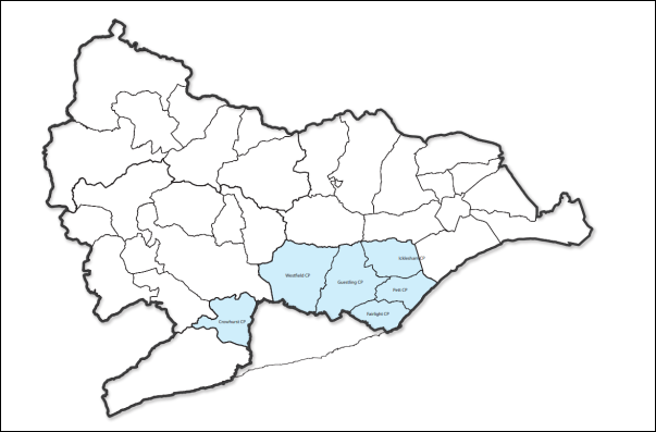
Includes the parishes of Crowhurst, Fairlight, Guestling, Icklesham (west), Pett and Westfield
Vision for Southern Rother and the Hastings Fringes Comment
Sensitive development will be delivered in the Hastings Fringes where it is well connected to the urban fabric of Hastings, to public and active transport routes, and to key services and facilities. Development will be appropriately designed taking account of the landscape setting of the High Weald National Landscape which wraps around the urban edge of Hastings.
Connections and accessibility to settlements in Southern Rother that are near to Hastings will be enhanced through improved public transport, active travel, and highway improvements through a vision and validate led approach. This will ensure that wider services and facilities can continue to be accessed, enabling residents to live well locally and have healthy lifestyles. Sensitive small-scale development will be delivered in villages, at densities consistent with the surrounding area, where it is sustainable to do so and does not negatively impact the setting of the High Weald National Landscape.
Where greater opportunities for development arise in larger, more sustainable villages, residential development will enable enhancement to public realm and community facilities. Growth will also help support existing facilities and services in the village, ensuring health and wellbeing and community cohesion is maintained and improved.
There is potential to deliver 377 dwellings and 6,000 sqm of employment floorspace across the Southern Rother and Hastings Fringes sub-area.
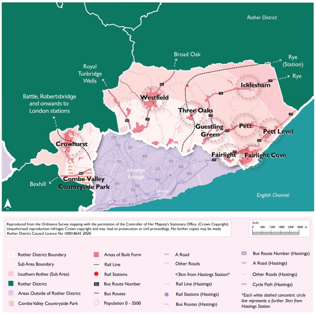
11.1The parishes which form the sub area of Southern Rother and the Hastings Fringes are Crowhurst, Fairlight, Guestling, part of Icklesham (Icklesham village only), Pett and Westfield, and all the settlements within them.
11.2Southern Rother and the Hasting Fringes is characterised by a mixture of distinct villages and settlements of varying sizes, also including development that extends from the built-up area of Hastings.
11.3The areas that directly extend from Hastings are defined as ‘Hastings Fringes’ for the purposes of this Local Plan. This encompasses areas within Guestling and Westfield parishes along Westfield Lane, Beaney’s Lane, Woodlands Way, Parkwood Road, Sandhurst Gardens, Stonestile Lane, Chowns Hill, Ivyhouse Lane, Rock Lane and Batchelor’s Bump.
11.4A high proportion of the areas within the Hastings Fringes are within the High Weald National Landscape, and many areas relate more to their rural surroundings than to the urban centre of Hastings. The topography and landscape setting of some of these areas mean that it is important that most land remains as countryside. There are, however, opportunities for well-designed and sensitive residential and employment development which will be well connected to the surrounding areas.
11.5As well as areas defined within Hastings Fringes, there are also neighbouring settlements within Southern Rother which are geographically close to Hastings. There are strong radial links with Hastings and the settlements of Crowhurst, Fairlight Cove, Guestling Green, Pett, Three Oaks and Westfield, and as such, a sensitive level of growth can be accommodated in some of these smaller settlements in locations that are considered sustainable.
11.6 The Local Plan includes site allocations for both residential and employment development in the sub area, and the level of development proposed is summarised in the table below. Growth is in the settlements of Crowhurst, Fairlight Cove, Guestling Green, Icklesham, Three Oaks and Westfield, as well in the Hastings Fringes areas around Beaney’s Lane, Ivyhouse Lane and Rock Lane.
11.7The settlements where proposed sites for allocation have been identified are in areas with a mix of good, fair and poor levels of sustainability as defined through the Settlement Study with the sites adjoining the built-up area of Hastings being generally most sustainable. The levels of development proposed are broadly consistent with these sustainability ratings with many of these settlements (Crowhurst, Guestling Green, Icklesham and Westfield) containing a primary school. Crowhurst and Three Oaks both contain a railway station. The sites proposed within the Hastings Fringes are in locations which can access the range of services and facilities within Hastings borough, including primary and secondary schools as well as more frequent bus services than the settlements in the rest of the Southern Rother area.
11.8While Guestling Green and Three Oaks both score poorly in sustainability terms through the settlement study, Guestling Green does benefit from its regular bus service to Rye and Hastings and also its primary school. A small residential site allocation is included at Three Oaks to help support the vitality of the settlement and the services, even if limited, within the settlement.
11.9No proposed sites for allocation have been identified in Pett parish or the other Hastings Fringes settlement areas identified at the start of this section. Pett is highly constrained in landscape terms, with the northern part being predominately located on a prominent ridgetop and the sloping topography meaning new development would be of high visual sensitivity and in many instances require significant groundworks to create developable sites, which would be harmful to the landscape and character of the High Weald National Landscape. Pett Level, in the southern part of the parish, is characterised by large areas of land within Flood Zone 3 as well as being adjacent to nationally and internationally protected habitats within the Dungeness, Romney Marsh and Rye Bay Ramsar site and Hastings Cliffs to Pett Beach Site of Special Scientific Interest. There are also very limited services within Pett to serve new development. Many of the sites within the remaining Hastings Fringes areas are within a countryside landscape setting where development would have a harmful impact on the High Weald National Landscape.
11.10 The table below illustrates the proposed development strategy for Southern Rother and the Hastings Fringes in terms of the numbers of dwellings and the amount of employment floorspace proposed to be delivered over the Plan Period, per settlement. These figures have been derived from the total amount of development proposed through the site allocations.
Figure 11.2: Southern Rother and the Hastings Fringes Development Strategy: Summary
|
Settlement Area |
Total housing (dwelling nos) |
Total employment floorspace (sqm) |
|
Rock Lane and Austen Way (Guestling parish) |
16 |
2,500 |
|
Westfield |
70 |
3,500 |
|
Woodlands Way and Parkwood Road (Westfield parish) |
104 |
0 |
|
Crowhurst |
49 |
0 |
|
Icklesham |
68 |
0 |
|
Fairlight Cove |
35 |
0 |
|
Guestling Green |
23 |
0 |
|
Three Oaks |
12 |
0 |
|
Total Growth |
377 |
6,000 |
Sustainability Coding for Settlements (Source: Rother Settlement Study, 2024)
|
Highly sustainable |
Very Good sustainability |
Good sustainability |
Fair sustainability |
Poor sustainability |
Very Poor sustainability |
Crowhurst
Parish: Crowhurst
Policy CR1: Land at Station Road and Forewood Lane, Crowhurst Comment
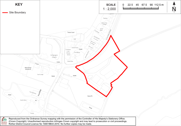
The site is allocated for residential development comprising 25 dwellings.
Development on this site must:
i. Provide a policy-compliant amount of on-site affordable housing in line with policy HOU2 of the Rother Local Plan;
ii. Include 40% of the housing to be either one- or two-bedroom homes proportionately allocated across the market and affordable tenures in accordance with the Crowhurst Neighbourhood Development Plan;
iii. Not exceed two storeys in accordance with the Crowhurst Neighbourhood Development Plan;
iv. Incorporate the retention and conversion of the long brick barn in the southern part of the site;
v. Allow for a comprehensive scheme to be developed across the whole site in the event the parcels of land come forward separately in accordance with Policy DEV2 of the Rother Local Plan;
vi. Include a significant area of green infrastructure, to include public open space and biodiversity net gain, across the central part of the site;
vii. Include a vehicular access from Station Road;
viii. Include appropriate pedestrian infrastructure inside and outside the site to link to footways on the southern side of Forewood Lane;
ix. Include pedestrian access onto the Public Right of Way (Crowhurst 8a) that is within the northern part of the site as well as enabling access to land to the west which is earmarked in the Crowhurst Neighbourhood Development Plan for a village green/community space;
x. Retain and enhance the existing trees and hedgerows on the boundaries and within the site as well as additional planting buffers on the north-east and southern boundaries in line with the Crowhurst Landscape Character, Sensitivity and Capacity Assessment (CLCSCA);
xi. Be designed to protect the settings of the Grade I listed “Parish Church of St George” and the Grade II listed “Ruins of the Old Manor House”, which is also a Scheduled Monument;
xii. Include any necessary off-site highway works necessary to make the development acceptable;
xiii. Be in compliance with the Crowhurst Neighbourhood Plan Design Guide and in line with Figure 4.3 in Policy CH2 in the Crowhurst Neighbourhood Plan 2025.
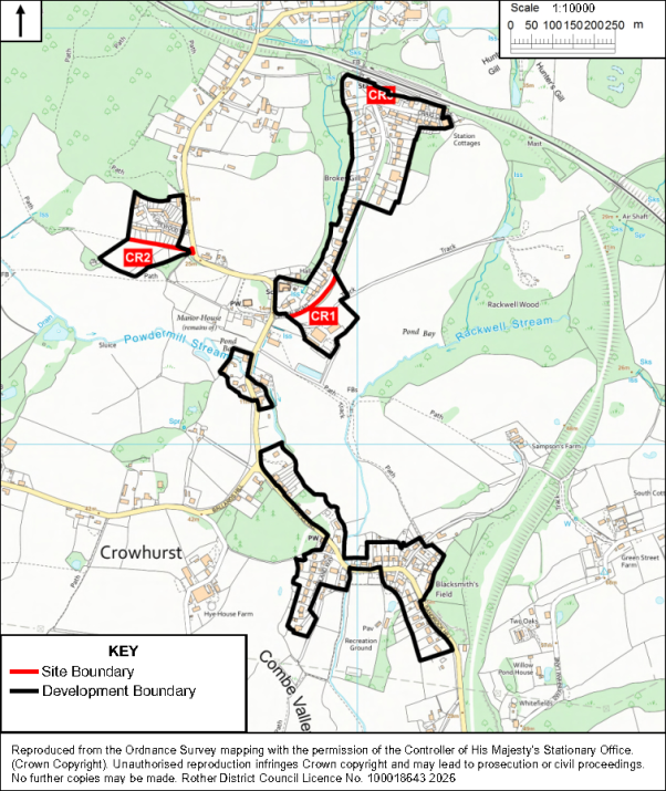
11.11The site comprises greenfield land in the centre of Crowhurst with agricultural buildings on part of the site. Part of it was originally allocated as site CH1 through the Crowhurst Neighbourhood Development Plan (reviewed 2025). The southern part of the site forms a logical extension to the original allocation and enables an increase in dwelling numbers.
11.12 The site is within the Village Area Type, has a site size of 1.41 hectares and an indicative developable area of 0.71 hectares. It is allocated for some 25 dwellings at an indicative residential density of 35 dwellings per hectare.
11.13The site is within the High Weald National Landscape and therefore a sensitive form of development is required in line with Local Plan policies. The southern part of the site is within the Strategic Gap, although given the current agricultural units on the site there is a form of built development currently present. The long brick barn within the site is a prominent feature in the local landscape, enhancing the rural character of the area, and for these reasons and to minimise the landscape impact of additional development in the Strategic Gap the policy requires its retention and conversion as part of the development of the site. The policy also outlines that the open space should be in the central part of the site to maintain a separation to the wider Strategic Gap. The Public Right of Way in the northern part of the site is to be retained and enhanced. The site also contains an Area that Could become of Importance for Biodiversity (ACIB) that is defined and mapped in the East Sussex and Brighton & Hove Local Nature Recovery Strategy (LNRS). Due regard must be taken to the priorities and measures set out within the LNRS.
11.14To the south and west of the site are areas of land within Flood Zones 2 and 3 as well as areas at risk of surface water flooding and therefore Sustainable Drainage features will be required on site to not increase the risk of nearby flooding. The site lies within the Cuckmere and Pevensey Management Catchment. Therefore, early pre-application engagement with the Lead Local Flood Authority and the Pevensey and Cuckmere Water Level Management Board will be needed to ensure the provision of appropriate Sustainable Drainage (SuDS) in accordance with Policy ENV3.
11.15 There are two listed buildings nearby to the site, the Grade I listed “Parish Church of St George” and the Grade II listed “Ruins of the Old Manor House” which is also a Scheduled Monument, and their settings will need to be preserved. An Archaeological Notification Area is adjacent to site’s northwestern boundary and extends away from the site to the southwest.
11.16A comprehensive scheme across the whole site (including access and the provision of affordable housing and smaller dwellings) should be provided for, in the event of the two parcels of land (the original NP allocation and the additional section) coming forward separately. The site is adjacent to land earmarked in the Crowhurst Neighbourhood Development Plan for a village green/community space and development of the site will need to make provision for accessing this area.
Policy CR2: Land south of Forewood Rise, Crowhurst Comment
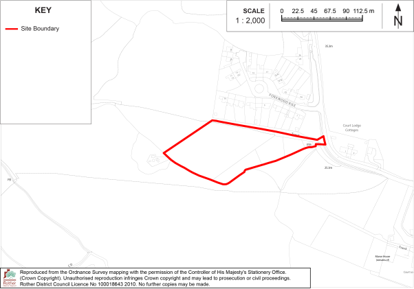
The site is allocated for residential development comprising 18 dwellings.
Development on this site must:
i. Provide a policy-compliant amount of on-site affordable housing in line with policy HOU2 of the Rother Local Plan;
ii. Include 40% of the dwellings to be either 1- or 2-bedroom homes proportionately allocated across the market and affordable tenures in accordance with the Crowhurst Neighbourhood Development Plan policy;
iii. Not exceed two storeys in accordance with the Crowhurst Neighbourhood Development Plan;
iv. Include a significant area of green infrastructure, to include public open space and biodiversity net gain, across the southern and western parts of the site, as well as a Children’s Local Area for Play in accordance with the Neighbourhood Plan;
v. Include a vehicular access from Forewood Lane to the satisfaction of the Highway Authority;
vi. Include appropriate pedestrian infrastructure inside and outside the site to link to footways on the southern side of Forewood Lane;
vii. Include pedestrian access onto the Public Rights of Way (Crowhurst 5a and Crowhurst 6a) that are inside the northern boundary and south of the site respectively. The route of the 1066 County Walk (Crowhurst 5a) is to be retained and an enhanced setting achieved;
viii. Retain and enhance the existing trees and hedgerows on the boundaries. New strategic landscaping which shall be provided along the entirety of the southern boundary and western boundary of the site, in accordance with the Powdermill Valley Landscape Strategy in the Crowhurst Landscape Character, Sensitivity and Capacity Assessment (CLCSCA);
ix. Include any necessary off-site highway works necessary to make the development acceptable;
x. Be in compliance with the Crowhurst Neighbourhood Plan Design Guide and in line with Figure 4.5 in Policy CH2 in the Crowhurst Neighbourhood Plan 2025.
11.17The site comprises a greenfield field in the west of Crowhurst. It was originally allocated as site CH2 in the Crowhurst Neighbourhood Development Plan (reviewed 2025),
11.18The site is within the Village Area Type, has a site size of 1.03 hectares and an indicative developable area of 0.67 hectares. It is allocated for some 18 dwellings at an indicative residential density of 27 dwellings per hectare.
11.19 The site is within the High Weald National Landscape and therefore a sensitive form of development is required in line with Local Plan policies. Part of the site where it joins Forewood Lane are at risk of surface water flooding and a safe access will need to be demonstrated. The site lies within the Cuckmere and Pevensey Management Catchment. Therefore, early pre-application engagement with the Lead Local Flood Authority and the Pevensey and Cuckmere Water Level Management Board will be needed to ensure the provision of appropriate Sustainable Drainage (SuDS) in accordance with Policy ENV3. Access to the 1066 Country Walk, the Public Right of Way inside the northern boundary, is to be retained and enhanced along with providing access to the Public Right of Way to the south of the site to encourage active travel. The site is close to the Fore Wood Site of Special Scientific Interest and also contains an Area that Could become of Importance for Biodiversity (ACIB) that is defined and mapped in the East Sussex and Brighton & Hove Local Nature Recovery Strategy (LNRS). Due regard must be taken to the priorities and measures set out within the LNRS.
Policy CR3: Land adjacent to Station Car Park, Crowhurst Comment
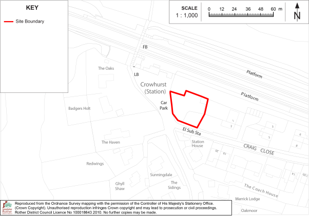
The site is allocated for residential development comprising 6 dwellings.
Development on this site must:
i. Provide a policy-compliant amount of on-site affordable housing in line with policy HOU2 of the Rother Local Plan;
ii. Be comprised of 1- or 2-bedroom dwellings only in the form of flats or apartments in accordance with the Crowhurst Neighbourhood Development Plan;
iii. Not exceed two storeys in accordance with the Crowhurst Neighbourhood Development Plan and not overlook existing properties;
iv. Include a vehicular access that does not adversely affect Craig Close residents in accordance with the Crowhurst Neighbourhood Development Plan;
v. Include appropriate pedestrian infrastructure inside and outside the site;
vi. Retain and enhance the existing mature trees on the site as far as practicable as informed by a tree survey to create an appropriate setting to the development;
vii. Include any necessary off-site highway works necessary to make the development acceptable;
viii. Be in compliance with the Crowhurst Neighbourhood Plan Design Guide.
11.20The site was originally allocated (site CH3) through the Crowhurst Neighbourhood Development Plan (reviewed 2025). The site is allocated for 6 dwellings in a flatted/apartment design.
11.21The site is within the Village Area Type, has a site size of 0.08 hectares and an indicative developable area of 0.08 hectares. It is allocated for some 6 dwellings at an indicative residential density of 75 dwellings per hectare.
11.22The site is within the High Weald National Landscape and therefore a sensitive form of development is required in line with Local Plan policies. The site is covered with trees which will need to be considered as part of the tree survey required in the policy and factored into the Biodiversity Net Gain calculations and delivery. The site lies within the Cuckmere and Pevensey Management Catchment. Therefore, early pre-application engagement with the Lead Local Flood Authority and the Pevensey and Cuckmere Water Level Management Board will be needed to ensure the provision of appropriate Sustainable Drainage (SuDS) in accordance with Policy ENV3.
Fairlight Cove
Parish: Fairlight
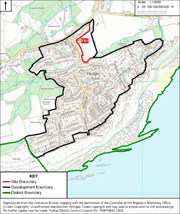
Policy FA1: Land east of Waites Lane, Fairlight Cove Comment
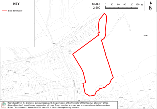
The site is allocated for residential development comprising 35 dwellings.
Development on this site must:
i. Provide a policy-compliant amount of on-site affordable housing in line with policy HOU2 of the Rother Local Plan;
ii. Include a significant area of green infrastructure, to include public open space and biodiversity net gain, across the southern and eastern parts of the site;
iii. Include a vehicular access from Pett Level Road;
iv. Include appropriate pedestrian infrastructure inside and outside the site to link to the northern side of Pett Level Road;
v. Retain and enhance the existing trees and hedgerows on the boundaries of the site;
vi. Include no built development in the parts of the site along the southern boundary which are shown to be at risk of surface water flooding;
vii. Make an acceptable connection to the local sewerage system in liaison with the service provider; and
viii. Include any necessary off-site highway works necessary to make the development acceptable.
11.23The site comprises a greenfield site within the Village Area Type. It has a site size of 3.24 hectares and an indicative developable area of 0.97 hectares. It is allocated for some 35 dwellings at an indicative residential density of 35 dwellings per hectare.
11.24While the site is within the High Weald National Landscape, it is visually enclosed and the impact on the HWNL from development would be limited. It would represent a logical extension to the built-up area, relating well to existing development on Waites Lane and Pett Level Road. Development will need to conserve and enhance this designated landscape. Buildings, access roads and open spaces should be of a high-quality design, reflecting the High Weald local vernacular.
11.25The site slopes gently down from north to south and a narrow strip of ghyll woodland is present on its southern boundary, which has in part been subsumed into the gardens of adjoining residential properties on Broad Way. The woodland will need to be retained in the site’s development, and an open landscape buffer in the form of a sizeable area of amenity space should be provided between it and the southern edge of the new development. In addition to protecting the woodland, this will provide an amenity function for new residents and could also contain necessary SuDS features.
11.26 The site is bordered to the north and west by residential properties fronting Pett Level Road and Waites Lane respectively. The boundaries with adjacent properties are relatively open and would benefit from appropriate planting to offer screening. A prominent tree belt defines the site’s eastern boundary, separating it from the adjoining field. This is important in enclosing the site from the wider countryside and should be retained and widened to create a broad tree belt with native species.
11.27Access will need to be from Pett Level Road to the north, which the Highway Authority has indicated would be acceptable in principle. A speed survey would need to be carried out in support of the planning application to determine appropriate visibility splays. The access should be in a suitable position in relation to the access to the adjacent dwelling (Robin Croft). Subject to the retention of visibility splays, tree planting should be carried out on either side of the access road to assist in screening the development from land to the east. Suitable pedestrian facilities will also be required, including footways on either side of the access which link to the existing pavement on the southern side of Pett Level Road to the east, and via a new pedestrian crossing to the pavement on the northern side of the road.
11.28 A pedestrian link from the development site to the west towards Waites Lane/Broad Way would be advantageous in the interests of improving permeability, although this would require the use of third-party land.
11.29Surface water drainage capacity is limited throughout the village, and a detailed surface water drainage strategy will need to be developed prior to the submission of a planning application for the site’s development. Flows and volumes will need to be attenuated prior to discharge to a watercourse and restricted to greenfield rates in accordance with Policy ENV2. To achieve this, significant water storage may be required within the site, which could affect the site layout. The use of soakaways is unlikely to be acceptable. There is an indication of surface water flooding on the site’s southern boundary, and this will require mitigation. The developer will also need to work with Southern Water to ensure appropriate sewerage infrastructure is provided to serve the development prior to its occupation.
11.30The site has high potential to contain archaeological remains and an archaeological assessment will need to be undertaken as part of the planning application for its future development, the results of which may inform the site layout.
Hastings Fringes (Guestling Parish)
Settlement: Hastings Fringes (Rock Lane and Austen Way)
Parish: Guestling
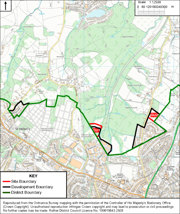
Policy GU1: Land north of A265, Ivyhouse Lane, Hastings Comment
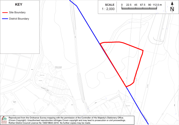
The site is allocated for employment development comprising some 2,500 sqm of new employment floorspace (use class E(g), B2 or B8).
Development on this site must:
i. Allow for a comprehensive scheme to be developed in conjunction with the adjoining land allocated within Hastings Borough;
ii. Include a vehicular access either from Ivyhouse Lane within Hastings Borough or Burgess Road;
iii. Make provision for new footpaths across the site to join the recently completed business development adjacent to the south, with land to the west in Hastings Borough, and extending northwards alongside the railway line for a potential future footpath link joining the existing public rights of way;
iv. Provide an appropriate financial contribution, as agreed by East Sussex County Council Rights of Way Team, towards off-site pedestrian bridge works across the valley;
v. Not detract from the principles set out in Policy GU3 relating to the adjacent Rock Lane Urban Fringe Management Area;
vi. Take account of Southern Water’s underground infrastructure in the design and layout of the site. Easements would be required, which may affect the site layout or require diversion, and these should be clear of all proposed buildings and tree planting;
vii. Include a landscape buffer to the north of the site which partly overlaps with areas shown to be at risk of surface water flooding;
viii. Include any necessary off-site highway works necessary to make the development acceptable;
ix. Be informed by agreed contamination, land stability and geotechnical reports.
11.31The site comprises part of an undeveloped, partly wooded area adjacent to the existing well-established and fully occupied Ivyhouse Lane industrial estate, located within Hastings borough. It also adjoins land allocated in the Hastings Local Plan for employment development.
11.32The site has a site size of 1.10 hectares and an indicative developable area of 0.59 hectares. It is allocated for some 2,500 sqm of new employment floorspace. This applies to just the land within Rother District. The allocation provides flexibility in terms of the specific use class of the employment use. The appropriate use class would be for determination at planning application stage, having regard to the nature of the particular proposal and the site constraints.
11.33The site is within the High Weald National Landscape and therefore a sensitive form of development is required in line with Local Plan policies. There are long views from Rye Road and Hastings Academy/North Seat on the ridge to the east over the wider valley area. However, this site itself is largely obscured due to topography and woodland cover. This area forms part of a larger open area astride the district/borough boundary with Hastings, with the area abutting the site to the east being identified as the Rock Lane Urban Fringe Management Area (see Policy GU3).
11.34Inclusion of a wider area for further modest employment use should provide additional scope to secure improvements to the visual appearance of the area, including the improved landscape management of the valley and create a more acceptable transition between the estate and the High Weald National Landscape beyond, whilst also providing managed public access across the valley.
11.35 Environmental and other constraints affecting the site include risks from surface water flooding. The site also contains and is surrounded by Areas that Could become of Importance for Biodiversity (ACIB) that are defined and mapped in the East Sussex and Brighton & Hove Local Nature Recovery Strategy (LNRS). Due regard must be taken to the priorities and measures set out within the LNRS.
11.36Due to the site sitting within the Impact Risk Zone (IRZ) for Hastings Cliffs to Pett Beach SSSI, Natural England should be consulted at an early stage. Any development proposal must seek to avoid or minimise negative impact on designated areas of landscape or environmental importance during both the construction and occupation phases of the development. There are also overhead power transmission and distribution lines over the site which will need to be safeguarded and have appropriate clearances and therefore early engagement with the relevant statutory body will be required.
11.37The site is well located in relation to existing employment development and services. Connections to the nearby footway infrastructure (via the land in Hastings Borough) to encourage active travel are required, as detailed above, as well as to the wider Public Rights of Way network to the north and northeast.
11.38The site has medium/high potential to contain archaeological remains from all periods. Appropriate archaeological assessment will need to be undertaken in support of a planning application for its future development. The findings of the assessment may need to inform the layout and design of the proposal.
Policy GU2: Brackendale, Rock Lane, Hastings Comment
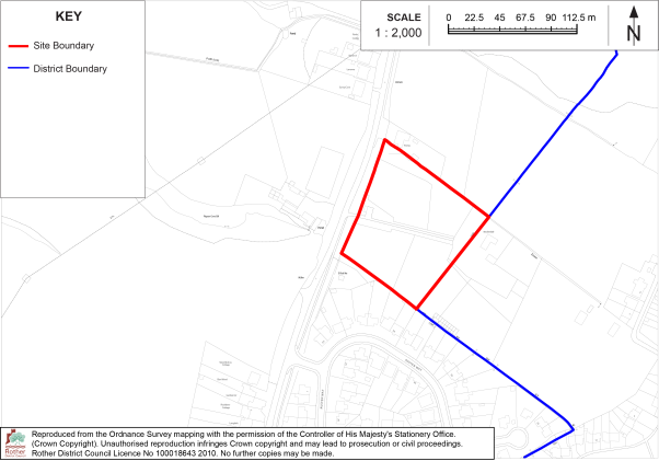
The site is allocated for residential development comprising 16 dwellings.
Development on this site must:
i. Provide a policy-compliant amount of on-site affordable housing in line with policy HOU2 of the Rother Local Plan;
ii. Include an area of green infrastructure to the west and south of the site for biodiversity net gain as shown on the indicative plan HF6 within the Rother Landscape Sensitivity Study 2026;
iii. Allow for a comprehensive scheme to be developed in conjunction with the adjoining land within Hastings Borough;
iv. Include a vehicular access from Rock Lane;
v. Include appropriate pedestrian infrastructure inside and outside the site to link to footways on the eastern side of Rock Lane;
vi. Retain an opportunity for a footpath/cycle link connection eastward towards Winchelsea Lane;
vii. Include no built development in the parts of the site (mainly in the northern section) which are shown to be at risk of surface water flooding;
viii. Retain and enhance the existing trees within and on the boundaries of the site;
ix. Include any necessary off-site highway works necessary to make the development acceptable;
x. Be informed by agreed land stability, land contamination and geotechnical reports.
11.39The site comprises a single residential dwelling in a large plot of land, adjacent to existing built development and is suitable for residential redevelopment. The plot straddles the district boundary, and there is land within the same ownership which lies within Hastings.
11.40The site is within the Live Well Locally Area Type, has a site size of 0.99 hectares and an indicative developable area of 0.41 hectares. It is allocated for some 16 dwellings at an indicative residential density of 40 dwellings per hectare. This applies to just the land within Rother District.
11.41The site is within the High Weald National Landscape and therefore a sensitive form of development is required in line with Local Plan policies. The retention and enhancement of mature trees on the roadside boundary with Rock Lane, together with an appropriate buffer, is required to assist in screening the development from longer views to the west. Environmental and other constraints affecting the site include risks from surface water flooding in the northern parts of the site (within Rother) and the policy requirements detailed above reflect this.
11.42The site is well located in relation to services in Hastings Borough, and connections to the existing footway infrastructure to encourage active travel are required, as detailed above.
11.43The site adjoins land within Hastings Borough. Hastings Borough Council’s (HBC’s) Local Plan policies require land stability and geotechnical reports for sloping sites and relevant developments, and consequently, this requirement is included as part of the policy to align with the HBC position. In addition, the site is adjacent to a former brick works which has long been developed as Austen Way. Therefore, given this proximity, a land contamination report will also be required.
Policy GU3: Rock Lane Urban Fringe Management Area Comment
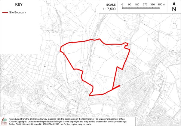
- The land between Ivyhouse Lane and Rock Lane is allocated as the Rock Lane Urban Fringe Management Area. Development that would harm the openness of this Urban Fringe Management Area or its significance and value to the local community will not be permitted.
- Landscape management proposals which improve the landscape character, green infrastructure, biodiversity interest or formal access opportunities within this area will be supported, subject to compatibility with other policies of the Plan. Further enhancements can be achieved through the East Sussex and Brighton & Hove Local Nature Recovery Strategy.
- Development in the vicinity of the Urban Fringe Management Area should support the principles of its designation.
11.44The area of land north of Hastings either side of the railway as it approaches The Ridge, with Rock Lane to the east and Ivyhouse Lane to the west, is identified as an area of potential for a joint urban fringe management approach. It lies within the High Weald NL, but its quality could be improved. Moreover, it could provide a valuable amenity for the surrounding areas, especially if access opportunities were increased.
11.45There is an opportunity in this location to facilitate the creation of an area of multifunctional green space as a buffer between town and countryside. The Management Area overlaps with both Areas of Particular Importance for Biodiversity (APIB) and Areas that Could become of Importance for Biodiversity (ACIB) that are both defined in East Sussex and Brighton & Hove Local Nature Recovery Strategy. Therefore, there are further opportunities to implement the principles, priorities and measures to help enhance nature in this area.
11.46 The area has fallen into poor management, as it is not especially attractive for agricultural use and, due to this neglect, some areas are misused for anti-social behaviour. At the same time the area is well used as informal space, notably for dog walking, and this use could be formalised and greatly enhanced to be of greater benefit for the local population. Recently completed development sites within Ivyhouse Land Industrial Estate and on Rock Lane have reinforced the need to formalise access to this area through the creation of a new formal footpath network and the introduction of improved management of woodland and the wider countryside to protect existing nature and biodiversity. This Policy provides an opportunity to secure the further future management of the area as green space for the local population.
11.47Therefore, development in this locality, including that allocated through policy GU1, should be viewed in the context of a wider area-based initiative to improve the landscape quality and formal access to the countryside to establish an appropriate transition area between the built-up area of Hastings and the High Weald NL countryside.
Guestling Green
Parish: Guestling
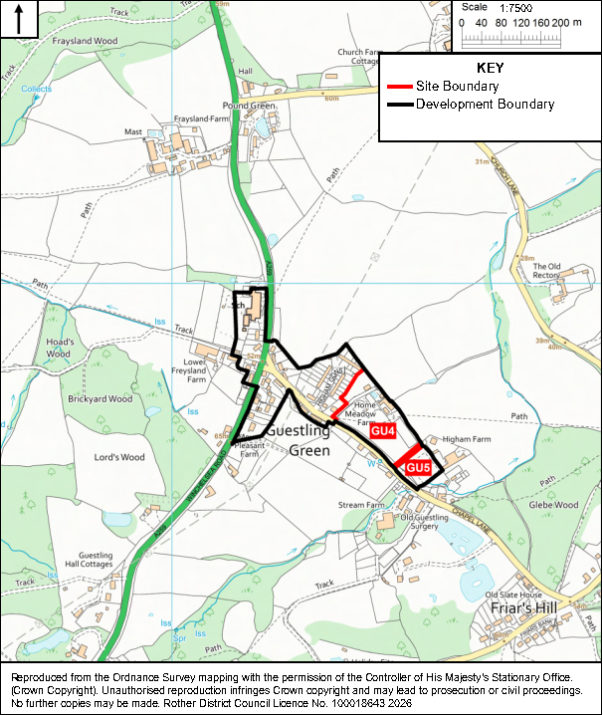
Policy GU4: Wild Meadows, Chapel Lane, Guestling Green Comment
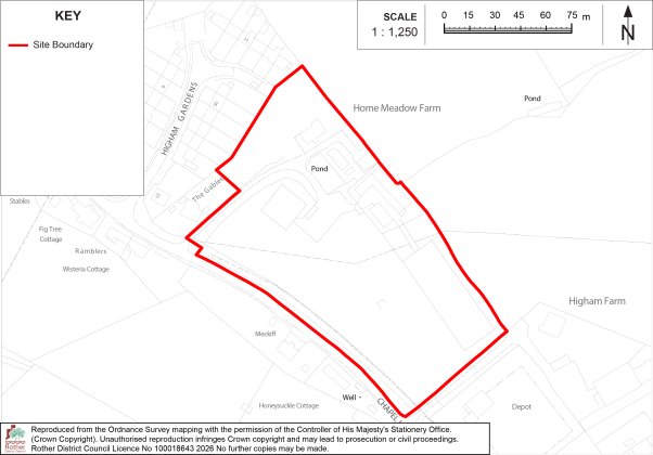
The site is allocated for residential development comprising 15 dwellings.
Development on this site must:
i. Provide a policy-compliant amount of on-site affordable housing in line with policy HOU2 of the Rother Local Plan;
ii. Restrict built development to just the area south of the Public Right of Way as shown on the indicative plan SO5 within the Rother Landscape Sensitivity Study 2026;
iii. Include a significant area of green infrastructure, to include public open space and biodiversity net gain, across the parts of the site north of the Public Right of Way;
iv. Include a vehicular access from Chapel Lane;
v. Include appropriate pedestrian infrastructure inside and outside the site;
vi. Include pedestrian access onto the Public Right of Way (Guestling 37) that crosses the site;
vii. Include no built development in the parts of the site (including the current stable buildings) along the northern boundary which are shown to be at risk of surface water flooding;
viii. Be informed by an ecological and tree survey to inform the layout and design;
ix. Retain and enhance the existing trees and hedgerows within and on the boundaries of the site;
x. Be designed to protect the amenity of the neighbouring properties;
xi. Be designed to preserve the setting of the Grade II listed building “Honeysuckle Cottage” to the south of the site;
xii. Include any necessary off-site highway works necessary to make the development acceptable.
11.48The site comprises an existing large garden area associated with an existing residential property as well as land used for equestrian uses including a sand school and stables. It is nearby to existing built development within Guestling Green and is suitable for residential development.
11.49The site is within the Village Area Type, has a site size of 1.30 hectares and an indicative developable area of 0.44 hectares. It is allocated for some 15 dwellings at an indicative residential density of 34 dwellings per hectare.
11.50It is within the High Weald National Landscape and therefore a sensitive form of development is required in line with Local Plan policies. Parts of the site are more sensitive in landscape terms due to longer views being gained from the northeast. Therefore, only the southwestern part of the site is considered suitable for residential development. Environmental and other constraints affecting the site include risks from surface water flooding. There is a need to protect and retain the existing trees and hedgerows that border the site in the interests of conserving the rural character of the locality and for biodiversity reasons, and the policy requirements detailed above reflect this.
11.51 A sensitive design will also be needed to preserve the setting of nearby listed buildings. Built form should be modest in scale and particular care should be given to roofscape, materials, boundary treatments and public realm detailing, including the use of clay tile, weatherboarding, tile-hanging, hedgerow boundaries, soft verges and limited external lighting. The access and any associated highways work should not erode the rural character of Chapel Lane and the setting of the nearby listed buildings, subject to compliance with the Highways Authority requirements.
11.52The site is well located in relation to the primary school and a bus route, but offsite footway improvements will be required to ensure safe pedestrian access. The Public Right of Way through the site is to be retained and enhanced. The site is nearby to the A259 which is part of the Strategic Road Network and there will be a need to comply with any requirements from National Highways will be required, including the potential requirement for an appropriate and proportional Transport Statement or Assessment, in addition to any requirements from the Local Highway Authority.
Policy GU5: Former Guestling Highways Depot, Guestling Green Comment
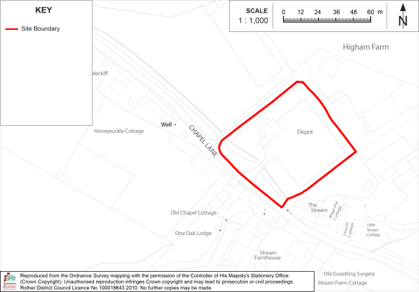
The site is allocated for residential development comprising 8 dwellings.
Development on this site must:
i. Provide a policy-compliant amount of on-site affordable housing in line with policy HOU2 of the Rother Local Plan;
ii. Use the existing vehicular access from Chapel Lane subject to the approval of the Highway Authority;
iii. Include appropriate pedestrian infrastructure inside and outside the site;
iv. Include no built development in the southern parts of the site which are shown to be at risk of surface water flooding;
v. Be planned to ensure future access to existing sewerage infrastructure for maintenance and upsizing purposes;
vi. Retain and enhance the existing trees and hedgerows on the boundaries of the site, to include additional planting where necessary to provide screening of the site;
vii. Be designed to preserve the setting of the Grade II listed buildings “Honeysuckle Cottage” and “The Stream/ Magnolia Cottage” to the west and south-east of the site;
viii. Include any necessary off-site highway works necessary to make the development acceptable.
11.53The site comprises a former County Council Highways Depot now used as a depot by a private company but available for potential redevelopment during the Plan period. It is nearby to existing built development within Guestling Green. While its re-use for employment purposes could be considered in line with Local Plan policies that seek to retain such uses, in this case the site is not ideally located for business use due to its limited size, access via a narrow lane and adjoining sensitive uses. Furthermore, the existing depot use is limited in terms of its employment potential. Therefore, in this instance, an alternative residential use is appropriate.
11.54The site is within the Village Area Type, has a site size of 0.39 hectares and an indicative developable area of 0.23 hectares. It is allocated for some 8 dwellings at an indicative residential density of 35 dwellings per hectare.
11.55The site is well located in relation to the primary school and a bus route, but offsite footway improvements will be required to ensure safe pedestrian access. Such improvements, together with any works to the existing access, will need to be sensitively designed to avoid harming the rural character of Chapel Lane and preserve the setting of nearby listed buildings.
11.56The site is within the High Weald National Landscape (HWNL) although it is brownfield and well screened from longer views into the landscape to the north and northeast by existing boundary vegetation. Subject to the retention of boundary trees and hedges and their supplementing with additional planting where necessary, together with sensitive access works as detailed above, a small-scale residential development can be accommodated.
11.57 Environmental and other constraints affecting the site include risks from surface water flooding which are largely confined to the south-eastern boundary, and a grade II listed pair of cottages to the south-east and the policy requirements detailed above reflect these. Redevelopment of the site creates the opportunity to restore a softer village-edge character and reduce the existing visual intrusion of the depot. Built form should be modest in scale and particular care should be given to roofscape, materials, boundary treatments and public realm detailing, including the use of clay tile, weatherboarding, tile-hanging, hedgerow boundaries, soft verges and limited external lighting. Any alterations to the existing access and any other associated highways works should not erode the rural character of Chapel Lane and the setting of the nearby listed buildings, subject to compliance with the Highways Authority requirements.
11.58 Southern Water infrastructure crosses the site and may require easements or diversions. The site is nearby to the A259 which is part of the Strategic Road Network and there will be a need to comply with any requirements from National Highways, in addition to any from the Local Highway Authority.
Three Oaks
Parish: Guestling
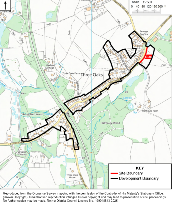
Policy GU6: Field at Halfhouse, Butchers Lane, Three Oaks Comment
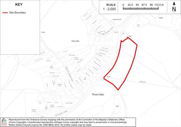
The site is allocated for residential development comprising 12 dwellings.
Development on this site must:
i. Provide a policy-compliant amount of on-site affordable housing in line with policy HOU2 of the Rother Local Plan;
ii. Comprise of smaller dwellings of one to three bedrooms;
iii. Limit built development to the southern half of the site fronting Butchers Lane and include an area of public open space in the northern half of the site, including the land adjacent to the Ancient Woodland;
iv. Include a vehicular access from Butchers Lane;
v. Include appropriate pedestrian infrastructure inside and outside the site;
vi. Include pedestrian access onto the Public Rights of Way (Guestling 27a and Guestling 28) that cross the site;
vii. Include provision for the retention and future management of a buffer zone of semi-natural habitat, at least 15 metres wide, on the northern boundary, between the edge of development and the ancient woodland;
viii. Retain and enhance the existing mature oak tree in the southern corner and the hedgerows within and on the boundaries of the site, except for any hedgerow removed to create a suitable access. Any hedgerow removed must be replanted subject to the visibility requirements of the highways authority;
ix. Retain and protect the existing pond to the north of the site and provide an appropriate buffer to any built development including roadways, as informed by an ecological survey, to be completed;
x. Include any necessary off-site highway works necessary to make the development acceptable.
11.59The site comprises the roadside portion of a large, open agricultural field. It is opposite existing built development within the northern part of Three Oaks and is suitable for residential development.
11.60The site is within the Village Area Type, has a site size of 0.80 hectares and an indicative developable area of 0.36 hectares. It is allocated for some 12 dwellings at an indicative residential density of 35 dwellings per hectare.
11.61It is within the High Weald National Landscape and therefore a sensitive form of development is required in line with Local Plan policies. Environmental and other constraints affecting the site include Ancient Woodland, Priority Habitat and a pond adjacent to the site to the north, and the existing trees and hedgerows that border the site and the policy requirements detailed above reflect these. The Ancient Woodland to the north also forms part of an Area of Particular Importance for Biodiversity (APIB) that is defined and mapped in the East Sussex and Brighton & Hove Local Nature Recovery Strategy (LNRS). Due regard must be taken to the priorities and measures set out within the LNRS. The adjacent pond may also give rise to risks from surface water flooding and therefore an appropriate buffer is required. The site and wider field also fully comprise an historic field boundary.
11.62 Development in this location impacts on an undeveloped field and will have some impact on the National Landscape. However, a short row of dwellings on the road frontage, where there is existing residential development on the opposite side of the road, is acceptable in terms of its impact on the settlement pattern and will provide for additional smaller and affordable dwellings in a village with otherwise limited development potential due to its sensitive landscape setting. The retention of the wider field and appropriate boundary treatment to the development will limit impacts on the wider landscape, and measures are included in the policy to protect High Weald features including field boundaries, mature trees and a pond. An historic field boundary used to be present slightly further to the east of the site and therefore, additional tree and hedge planting along this boundary would contribute towards re-establishing a field boundary, enhancing the HW character. A LVIA will be necessary in line with Policy LAN2.
11.63 The site is within walking distance of the railway station but there are no formal footways along Butchers Lane, and it is unlikely to be feasible to provide one, however, accessibility improvements will be required through the planning application. The Public Rights of Way through the site are to be retained and enhanced.
Icklesham
Parish: Icklesham
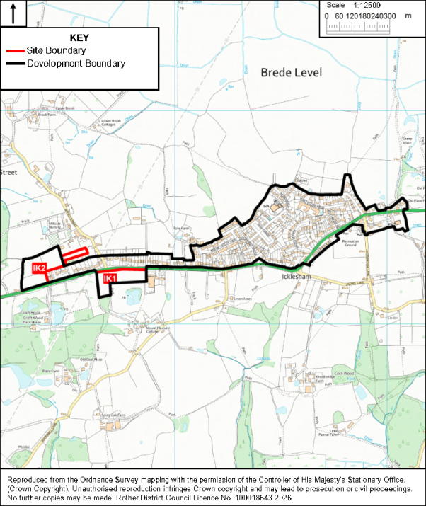
Policy IK1: Land adjacent to Little Sherwood Industry Park, Icklesham Comment
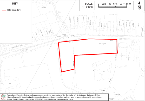
The site is allocated for residential development comprising 30 dwellings.
Development on this site must:
i. Provide a policy-compliant amount of on-site affordable housing in line with policy HOU2 of the Rother Local Plan;
ii. Include an area of green infrastructure, to include biodiversity net gain, across the southwestern corner of the site as shown on the indicative plan SO4 within the Rother Landscape Sensitivity Study 2026;
iii. Include a vehicular access from Main Road (A259);
iv. Include appropriate pedestrian infrastructure inside and outside the site to link to footways on the northern side of Main Road;
v. Retain and enhance the existing trees and hedgerows within and on the boundaries of the site, except for any hedgerow removed to create a suitable access. Any hedgerow removed must be replanted subject to the visibility requirements of the highway’s authority;
vi. Be designed to ensure that new residents are not adversely impacted by noise pollution from the adjacent employment use, in consultation with the Environmental Health department. Any physical structures forming part of any noise reduction scheme must respect the landscape character of the National Landscape;
vii. Retain and enhance connections to the Public Rights of Way (Icklesham 30a and 31b) within the site;
viii. Be planned to ensure future access to existing sewerage/water infrastructure for maintenance and upsizing purposes;
ix. Include any necessary off-site highway works necessary to make the development acceptable including a pedestrian crossing and the potential relocation of the bus stop to facilitate access into the site.
11.64The site comprises part of a field on the southern side of the A259 in Icklesham.
11.65The site is within the Village Area Type, has a site size of 1.7 hectares and an indicative developable area of 0.86 hectares. It is allocated for some 30 dwellings at an indicative residential density of 35 dwellings per hectare.
11.66The majority of the village’s built form lies on the northern side of the main road, and suitable locations for further development are limited due to the sensitive landscape setting of the village, which sits on a ridge and provides for sweeping views across the countryside to the north and south, beyond existing ribbon development on the A259. However, this small field is relatively enclosed from longer views and adjoins a small pocket of development on this southern side of the road and is considered suitable for a small-scale residential development.
11.67The site is within the High Weald National Landscape and therefore a sensitive form of development is required in line with Local Plan policies. Environmental and other constraints affecting the site include the Public Rights of Way within and adjacent to the site, and the policy requirements detailed above reflect these. Connections to the existing footway infrastructure to encourage active travel are required, as detailed above. The trees and hedgerows on the boundaries should be retained and enhanced with buffers to any development. Green Infrastructure must also be provided to create natural boundaries to the site as shown within the Rother Landscape Sensitivity Study 2026. Southern Water infrastructure crosses the site and may require easements or diversions.
11.68 Initial comments from National Highways, given the A259 is part of the Strategic Road Network, indicate an access can be made suitable in highways terms providing that there is a suitable separation distance (a minimum of 50 metres) from the junction with Broad Street. In addition, the current bus stop lay-by may need to be relocated to achieve the required visibility. This may involve the removal of sections of the established hedgerow, and the policy requirements reflect the requirement for a new hedgerow to be replanted on the site. These and any other requirements from National Highways will need to be complied with.
Policy IK2: Land adjacent to Orchard Close, Icklesham Comment
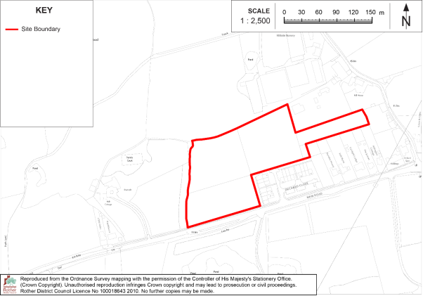
The site is allocated for residential development comprising 38 dwellings.
Development on this site must:
i. Provide a policy-compliant amount of on-site affordable housing in line with policy HOU2 of the Rother Local Plan;
ii. Allow for a comprehensive scheme to be developed across the whole site in the event the parcels of land come forward separately;
iii. Include a significant area of green infrastructure, to include public open space and biodiversity net gain, across the western and eastern parts of the site which also enhances the Deciduous Woodland and Traditional Orchard Priority Habitats adjacent to the site;
iv. Ideally include a vehicular access from Orchard Close;
v. Include appropriate pedestrian infrastructure inside and outside the site to link to footways on the northern side of Main Road (A259);
vi. Include no built development in the southern part of the site which is shown to be at risk of surface water flooding;
vii. Retain and enhance the existing trees and hedgerows on the boundaries of the site;
viii. Include any necessary off-site highway works necessary to make the development acceptable.
11.69The site comprises sections of two agricultural fields on the northern side of the A259 in Icklesham.
11.70 The site is within the Village Area Type, has a site size of 2.36 hectares and an indicative developable area of 1.08 hectares. It is allocated for some 38 dwellings at an indicative residential density of 35 dwellings per hectare.
11.71It relates well to adjoining development and is screened to some extent in the wider landscape, meaning it is considered suitable for residential development. The site is adjacent to a recently completed residential development, which was constructed as an affordable housing “rural exception site”. Drainage infrastructure associated with this development is present within this site and therefore development will need to be designed to take this into account.
11.72It is within the High Weald National Landscape and therefore a sensitive form of development is required in line with Local Plan policies. The policy requirements detailed above require the retention and enhancement of existing boundary trees and hedges and also require a large area of open space in the northern part of the site, as informed by the Landscape Sensitivity Assessment 2026. These measures are required in order to soften the site’s visual impact in longer views from the north and maintain the rural setting of this edge of the village.
11.73Environmental and other constraints affecting the site include some Deciduous Woodland Priority Habitat adjacent to the site to the west and Traditional Orchard Priority Habitat to the east. Both of these are Areas that Could become of Importance for Biodiversity (ACIB) that are defined and mapped in the East Sussex and Brighton & Hove Local Nature Recovery Strategy (LNRS). Due regard must be taken to the priorities and measures set out within the LNRS. There are also risks from surface water flooding and the policy requirements detailed above reflect these. The landscape sensitivity of the site and the underground water infrastructure related to Orchard Close running through this site constrain the overall developable area.
11.74Connections to the existing footway infrastructure to encourage active travel are required, as detailed above. Ideally the site should be accessed via the adjoining development, “Orchard Close” in order to avoid the construction of a second vehicular access onto the A259, part of the Strategic Road Network, in close proximity to that site. Initial comments from National Highways support reusing the existing access and requires an assessment to be conducted for any new access. These and any other requirements from National Highways will need to be complied with.
Hastings Fringes (Westfield Parish)
Settlement: Hastings Fringes (Woodlands Way and Parkwood Road)
Parish: Westfield
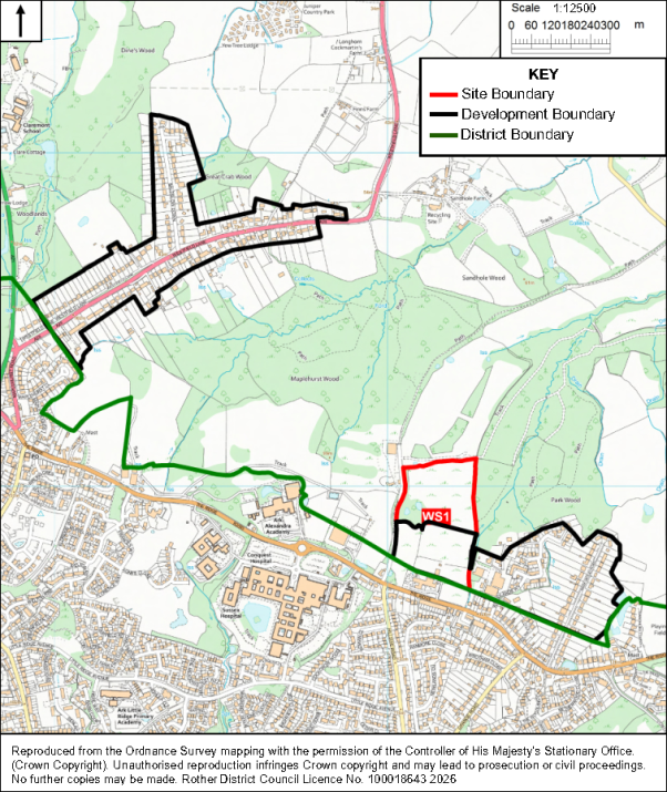
Policy WS1: Land east of Beaney’s Lane, Hastings Comment
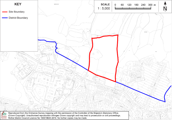
The site is allocated for residential development comprising 104 dwellings.
Development on this site must:
i. Provide a policy-compliant amount of on-site affordable housing in line with policy HOU2 of the Rother Local Plan;
ii. Allow for a comprehensive scheme to be developed in conjunction with the adjoining land allocated within Hastings Borough;
iii. Include a significant area of green infrastructure, to include public open space and biodiversity net gain, across the northern half of the site as shown on the indicative plan HF4 within the Rother Landscape Sensitivity Study 2026;
iv. Be informed by traffic modelling which demonstrates no unacceptable cumulative effects on the local highway network, including from other development in Hastings borough;
v. Include a vehicular access from The Ridge (within Hastings borough) in the southeast of the site;
vi. Include appropriate pedestrian infrastructure inside and outside the site to link to footways on the northern side of The Ridge; Include no built development in the parts of the site to the north and west which are shown to be at risk of surface water flooding;
vii. Be informed by ecological and hydrological survey work which demonstrates development will have no adverse impact on the integrity of the Maplehurst Wood Site of Special Scientific Interest;
viii. Include provision for the retention and future management of a buffer zone of semi-natural habitat, at least 15 metres wide, within the northeastern and western areas with the ancient woodland;
ix. Retain and enhance the existing trees on the boundaries of the site;
x. Retain and protect the existing ponds in the site and provide an appropriate buffer to any built development including roadways, as informed by an ecological survey to be completed;
xi. Protect the amenity of the adjacent Martha Trust site;
xii. Include any necessary off-site highway works necessary to make the development acceptable;
xiii. Be informed by agreed land stability and geotechnical reports.
11.75The site comprises an existing dwelling surrounded by a field with wooded boundaries which wraps around a small pocket of development on the northern side of The Ridge (B2093). The southern part of the field, within the same ownership (outside the site) is located in Hastings borough while the larger, northern, part is in Rother.
11.76The site is within the Live Well Locally Area Type, has a site size of 7.62 hectares and an indicative developable area of 2.61 hectares. It is allocated for some 104 dwellings at an indicative residential density of 40 dwellings per hectare. This applies to just the land within Rother District.
11.77The site is within the High Weald National Landscape (HWNL) and therefore a sensitive form of development is required in line with Local Plan policies. The site is substantially characterised as an assarted field which continues further north beyond the site boundary. Environmental and other constraints affecting the site include adjoining Ancient Woodland, Deciduous Woodland Priority Habitats and Tree Preservation Orders, risks from surface water flooding partly linked with ponds to the west, and the other existing trees across the site and boundaries which the policy requirements detailed above reflect. The site is also in close proximity to the Maplehurst Wood SSSI with the northern boundary approximately 130m south of the SSSI. The Ancient Woodland and Priority Habitats within and adjacent to the site are Areas of Particular Importance for Biodiversity (APIB) and Areas that Could become of Importance for Biodiversity (ACIB) that are defined and mapped in the East Sussex and Brighton & Hove Local Nature Recovery Strategy (LNRS). Due regard must be taken to the priorities and measures set out within the LNRS.
11.78 While the allocation is likely to be considered major development in the HWNL, it is justified in this location due to its close proximity to facilities and services within Hastings and having regard to the need to provide housing.
11.79Therefore, built development will need to be restricted to the southern half of the site where it would be most associated with the existing built development along The Ridge and would be read as an extension to the built form of Hastings. A large area of green infrastructure in the northern section will provide substantial buffers to the countryside and ancient woodland, as well as an amenity for future residents. The northern boundary of the developable area, as informed by Landscape Sensitivity Study 2026, should be defined with a mixed species native tree belt with a mosaic of scrub and grassland to establish a boundary which complements the rural character of the field beyond. This will also provide biodiversity connectivity between the Ancient Woodland in the western part of the site and the larger area of Ancient Woodland to the east. The pond provides a further opportunity for enhancing biodiversity on the site, subject to detailed ecological assessments and not harming the Ancient Woodland that surrounds it. Any development would also need to protect the amenity of the adjacent uses, including a care home, through providing natural buffers.
11.80The site is well located in relation to services within Hastings and connections to the existing footway infrastructure to encourage active travel are required, as detailed above. The site adjoins land within Hastings Borough. Hastings Borough Council’s (HBC’s) existing and emerging Local Plan policies require land stability and geotechnical reports for sloping sites and relevant developments, and consequently, this requirement is included as part of the policy to align with the HBC position. Overall the policy requirements and the mitigation measures required will ensure the development conserves and enhances the natural beauty of the HWNL.
Westfield
Parish: Westfield
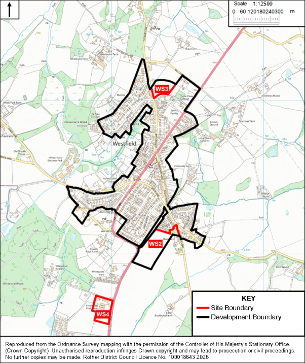
Policy WS2: Land at Moor Farm, Westfield Comment
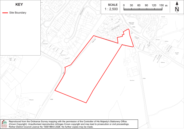
The site is allocated for residential development comprising 50 dwellings.
Development on this site must:
i. Provide a policy-compliant amount of on-site affordable housing in line with policy HOU2 of the Rother Local Plan;
ii. Include a significant area of green infrastructure, to include public open space and biodiversity net gain as informed by the Landscape Sensitivity Study 2026;
iii. Include a vehicular access from Westfield Lane (A28);
iv. Include appropriate pedestrian infrastructure inside and outside the site to link to the existing footways, including new footways to link the new development to the existing Westfield Lane and Moor Lane footways. Any sections of boundary hedgerow removed on Moor Lane should be replanted at the rear of the footway subject to highways visibility requirements; and any necessary improvements to the Stonestile Lane/Moor Lane junction are to be implemented;
v. Include pedestrian access onto the Public Right of Way (Westfield 44) that crosses the site;
vi. Retain and enhance the existing trees and hedgerows on the boundaries, save for the minimal amount of removal needed for the footway on Stonestile Lane/Moor Lane, and provide a new hedge on the southern boundary of the site and the vehicular access from the A28;
vii. Phase the occupation of development to align with the delivery of sewerage infrastructure, in consultation with the service provider;
viii. Be planned to ensure future access to existing sewerage infrastructure for maintenance and upsizing purposes;
ix. Respect the amenity value of adjoining residential properties on the northern and western boundaries;
x. Include any necessary off-site highway works necessary to make the development acceptable;
xi. Upgrade the closest bus stops on the A28, provide safe and suitable access to these, and provide financial contributions towards improvements to bus services;
xii. Preserve the setting of the Grade II listed building “Moor Farmhouse” to the east of the site.
11.81The site comprises part of a large field in the southern part of Westfield village and is suitable for residential development.
11.82 The site is within the Village Area Type, has a site size of 3.55 hectares and an indicative developable area of 1.43 hectares. It is allocated for some 50 dwellings at an indicative residential density of 35 dwellings per hectare.
11.83It is within the High Weald National Landscape and therefore a sensitive form of development is required in line with Local Plan policies. There are some High Weald features within the site although the large fieldscape is of modern origin, and the development provides an opportunity to reintroduce new field boundaries on the eastern and southern boundaries broadly in line with previous historic field boundaries. The development also allows for enhancing existing boundary trees and hedgerows, while also enhancing public access through links to the existing Public Right of Way. A substantial area of Green Infrastructure will be required. This may be appropriate across the southern half of the site which is more sensitive in landscape terms as informed by the Landscape Sensitivity Study 2026.
11.84The site is within an Archaeological Notification Area and has high potential for prehistoric, Roman (including a major Roman road) and medieval archaeological remains relating to the historic core of Westfield Moor. There is also a Grade II Listed Building just east of the site, and the policy requirements above reflect these constraints.
11.85Initial indications are that a vehicular access could be achieved onto Westfield Lane (A28), south of the bend, and connections to the existing footway infrastructure to encourage active travel are required, as detailed above. The design of this will need to be carefully considered to ensure it compatible with the potential area of green infrastructure in this part of the site as identified in the Landscape Sensitivity Study 2026.
11.86Initial indications from Southern Water show there may be limited local network capacity and phasing of the development may therefore be needed to coincide with network reinforcement prior to the occupation of all the dwellings. In addition, Southern Water infrastructure crosses the site and may require easements or diversions.
Policy WS3: Land on east side of Cottage Lane, Westfield Comment
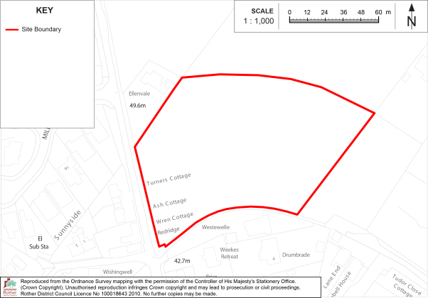
The site is allocated for residential development comprising 20 dwellings.
Development on this site must:
i. Provide a policy-compliant amount of on-site affordable housing in line with policy HOU2 of the Rother Local Plan;
ii. Include a significant area of green infrastructure, to include public open space and biodiversity net gain, across the site;
iii. Include a vehicular access from Cottage Lane;
iv. Include appropriate pedestrian infrastructure inside and outside the site, including footway provision and appropriate access and crossing to upgraded bus stops on the A28;
v. Include no built development in the southern part of the site which is shown to be at risk of surface water flooding;
vi. Include pedestrian access onto the Public Right of Way (Westfield 27) that is adjacent to the southern boundary;
vii. Retain and enhance the existing trees and hedgerows on the boundaries;
viii. Include on-site and off-site Biodiversity Net Gain for mitigation, compensation and enhancement measures;
ix. Include any necessary off-site highway works necessary to make the development acceptable.
11.87 The site comprises part of a field, previously a Christmas tree plantation but recently cleared, in the northern part of Westfield village. It is suitable for residential development having been granted outline planning permission for up to 20 dwellings in June 2025.
11.88The site is within the Village Area Type, has a site size of 1.19 hectares and an indicative developable area of 0.60 hectares. It is allocated for some 20 dwellings at an indicative residential density of 35 dwellings per hectare.
11.89 It is within the High Weald National Landscape and therefore a sensitive form of development is required in line with Local Plan policies. Environmental and other constraints affecting the site include risks from surface water flooding and the potential for archaeological remains as the site is within an Archaeological Notification Area and the policy requirements detailed above reflect these. Connections to the Public Right of Way to the south of the site should also be made.
11.90The site is subject to a Restocking Notice served by the Forestry Commission due to its recent clearance. However, this has been appealed by the landowner, and a decision is pending. If the Notice is upheld, the site will need to be replanted with trees and development will not, therefore, be able to come forward, despite the extant outline planning permission.
Policy WS4: Freshfields Farm, Westfield Lane, Westfield Comment
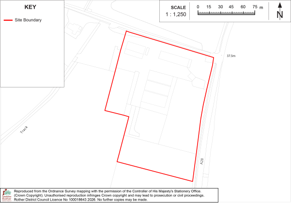
The site is allocated for employment development comprising some 3,500sqm of new employment floorspace (use class E(g), B2 or B8).
Development on this site must:
i. Use the existing vehicular access from Westfield Lane (A28) subject to the approval of the Highway Authority;
ii. Include appropriate pedestrian infrastructure inside and outside the site to link to the existing footways on the western sides of Westfield Lane;
iii. Be designed to be in keeping with the agricultural character of the site, including through the style of new buildings;
iv. Retain and enhance the existing trees and hedgerows on the site boundaries, and provide additional planting to the south and west;
v. Be designed to protect the amenity of the nearby residential properties;
vi. Be informed by a noise assessment to ensure no adverse impacts on the nearby residential properties;
vii. Include any necessary off-site highway works necessary to make the development acceptable;
viii. Upgrade the closest bus stops on the A28, provide safe and suitable access to these, and provide financial contributions towards improvements to bus services.
11.91 The site comprises two fields that form part of a larger network of fields located in the countryside to the south of Westfield village. There are existing buildings within the site used for agricultural, business and retail purposes and the site is suitable for a small expansion of the existing business uses.
11.92The site has a site size of 1.59 hectares. It is allocated for some additional 3,500sqm of new employment floorspace. The allocation provides flexibility in terms of the specific use class of the employment use. The appropriate use class would be for determination at planning application stage, having regard to the nature of the particular proposal and the site constraints.
11.93 It is within the High Weald National Landscape and therefore a sensitive form of development is required in line with Local Plan policies. While the site is separated from Westfield village, further employment development here accords with national planning policy which supports the sustainable growth and expansion of business in rural areas, both through conversion of existing buildings and well-designed, new buildings, recognising that sites to meet local business needs in rural areas may have to be found adjacent to or beyond existing settlements. Notwithstanding this, connections to the existing footway infrastructure on Westfield Lane will encourage active travel, as detailed above. A transport assessment will also be required to assess the potential impacts and mitigation required arising from additional vehicle movements including from heavy goods vehicles.
11.94Due to the site sitting within the Impact Risk Zone (IRZ) for Maplehurst Wood SSSI, Natural England should be consulted at the earliest possible stage. Any development proposal must seek to avoid or minimise negative impact on designated areas of landscape or environmental importance during both the construction and occupation phases of the development. The roadside hedgerow and verge adjacent to the eastern boundary is an Area that Could become of Importance for Biodiversity (ACIB) that is defined and mapped in the East Sussex and Brighton & Hove Local Nature Recovery Strategy (LNRS). Due regard must be taken to the priorities and measures set out within the LNRS.
