
Rother Local Plan 2025-2042 Regulation 19 (pre-submission) version September 2026
Chapter 9: Sub-Area Visions, Site Allocations and Area Policies
9.1 Rother’s Development Strategy has been split into five spatial sub-areas, as shown in below, which align with the Spatial Strategy detailed in Chapter 2 and Policy SS2 (Spatial Strategy for Rother). Each of the spatial sub-areas has its own vision and identified distribution of development (strategy). The five sub-areas comprise:
- Bexhill;
- Southern Rother and the Hastings Fringes;
- Battle and its cluster of connected settlements;
- Rye and its cluster of connected settlements; and
- Northern Rother – the settlements in the north-east of the district.
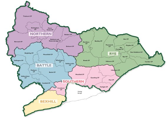
9.2 It is recognised that residents will utilise services and facilities in multiple major towns, villages and rural areas within and outside the district, to enable them to live well locally. While there is overlap, for clarity, settlements (and their identified growth potential) have been presented in only one of the five sub-areas.
9.3 In all five sub-areas there is open countryside. This relates to those areas outside of villages with development boundaries and includes farmland, woodland, hamlets and scattered development. Policy SS4 in Chapter 2 sets out the Strategy for the Countryside.
9.4 This chapter of the Local Plan sets out the Vision and Strategy for each of the five sub-areas, together with site allocations and some area-specific policies. It also includes a section for gypsy, traveller and travelling showpeople accommodation.
Site Allocations
9.5 Site allocations identify specific areas of land where development is expected to take place during the Plan Period. They demonstrate how the Local Plan will address Rother’s identified needs for housing, employment and other types of development. Site allocations support and help give effect to the Development Strategy for the district. They provide clarity about the locations where new development will be directed to and built, together with supporting infrastructure, so that growth is plan-led and happens in a sustainable way.
9.6 Site allocation policies specify the types of land-uses that are acceptable on specific sites along with guidelines on the amount of development considered to be achievable on them. Site allocations also set out requirements and measures to ensure that development is acceptable and responds positively to its local context. This may include, for example, provisions for protecting and enhancing green blue infrastructure, transport/highway mitigations or design guidance.
9.7 For each site allocation, a development capacity figure is provided. This is an ‘indicative’ figure for the amount of development that the Council considers is appropriate and deliverable on the site. The capacity figure should not be read prescriptively. The ‘actual’ amount of development on a site will be determined on a case-by-case basis through the development management process.
9.8 For site allocations with an existing (extant) planning permission, the development capacity reflects the capacity of the consented scheme, as this has been established as an acceptable amount of development. For housing site allocations where there is not an existing planning permission, the capacity figure is derived by applying a site density figure (in dwellings per hectare) to the ‘developable’ part of the site.[1] The density figure for sites in different areas of the district has generally been informed by findings of the Density Study (2026), also considering individual site constraints.
9.9 It is important to note that the Local Plan must be read as a whole. The site allocation policies do not cover all the policy requirements that development proposals will be required to comply with.
9.10 The land-uses prescribed by the site allocations respond to and seek to address the identified development needs for Rother. Development requirements and design guidelines have been set out for each site allocation, based on detailed site assessments and having regard to the NPPF and Local Plan policies.
