
Rother Local Plan 2025-2042 Regulation 19 (pre-submission) version September 2026
Chapter 14: Northern Rother Sub-Area: Vision, Strategy and Site Allocations
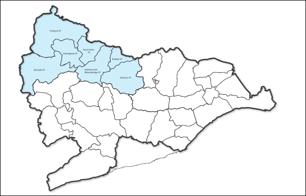
Includes the parishes of Bodiam, Burwash, Etchingham, Ewhurst, Hurst Green, Salehurst and Robertsbridge and Ticehurst
Vision for Northern Rother Comment
Northern Rother’s rural settlements and communities will continue to thrive, through sensitive residential development and growth in villages to create sustainable forms of development with a strong emphasis on protecting the landscape character and scenic beauty of the High Weald National Landscape. This will ensure that health and wellbeing and community cohesion is maintained and improved.
While many rural journeys continue to be undertaken by car, local environmental impacts are lessened due to an increase in the uptake of electric vehicles and a corresponding increase in available EV charge points. Connectivity between rural settlements and the Hastings-London rail line will be enhanced through promoting and improving sustainable and active transport infrastructure including walking, wheeling and cycling, enabling communities to lead healthy and active lifestyles.
The two stations at Etchingham and Robertsbridge will continue to act as transport hubs for wider villages in Northern Rother. Also, the area will continue to be served by Stonegate station.
There are opportunities for sensitive development in the sub-area during the timeframe of the Local Plan, where sustainable and related to an existing settlement, including those alongside the A21. Longer term (beyond the timeframe of the new Local Plan), and subject to funding, the delivery of significant improvements to create a sustainable transport corridor could open up opportunities for future development along the A21 corridor, which could be addressed in a plan review.
799 dwellings and 4,200 sqm of employment floorspace are allocated across the Northern Rother sub-area.
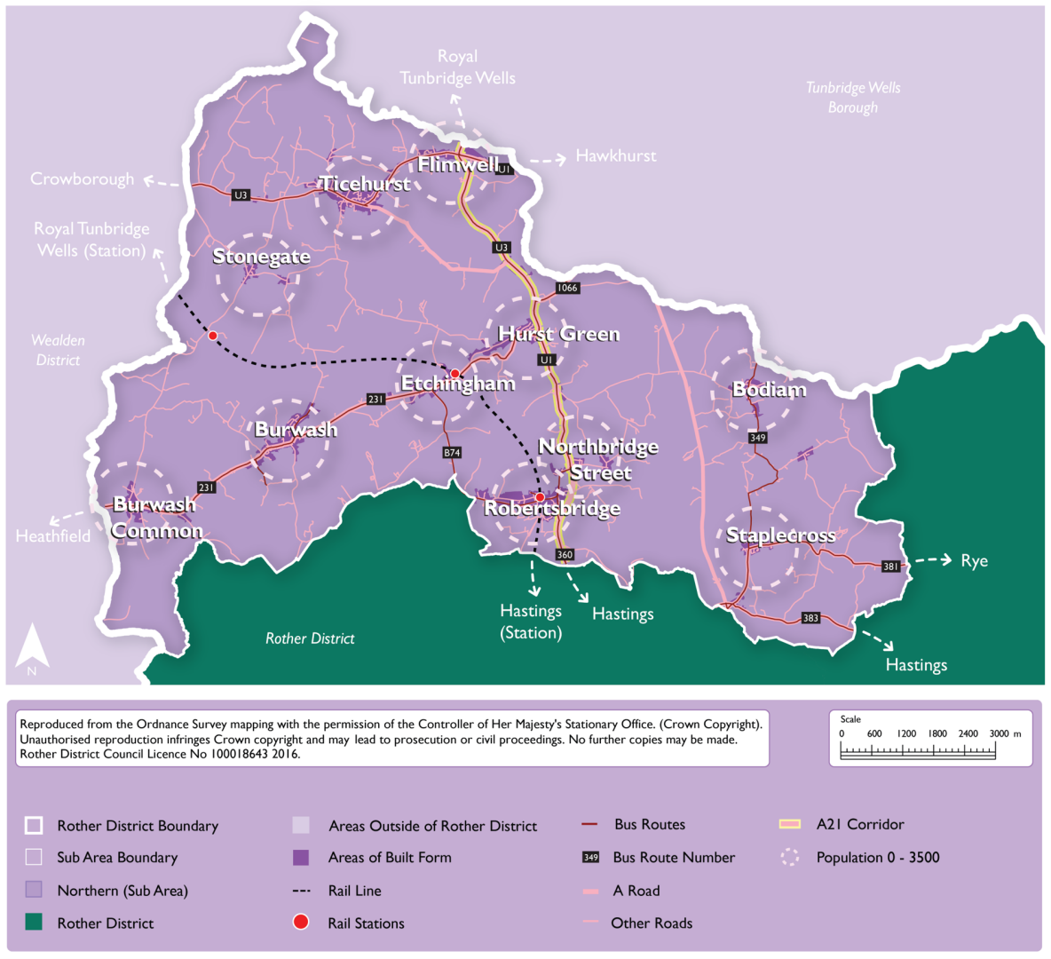
14.1The parishes which form the Northern Rother sub-area comprise Bodiam, Burwash, Etchingham, Ewhurst, Hurst Green, Salehurst and Robertsbridge, and Ticehurst.
14.2Northern Rother is rural in its nature, with the largest villages being Ticehurst, Robertsbridge, Burwash and Hurst Green. Robertsbridge, along with Etchingham, have railway stations utilised for commuting and general travel south to Hastings and north to Tunbridge Wells and to London. These settlements are more sustainable locations for sensitive growth; however, this is dependent on there being appropriate sites available, having regard to the constraints of the area including in terms of landscape and flood risk.
14.3Northern Rother is served by a strong network of village primary schools; however, many rural primary schools are operating under-capacity. Appropriate growth in these villages is therefore an important factor in securing the long-term viability of this rural school network and communities. Residents within Northern Rother are likely to use services and facilities outside of the district to the north in Tunbridge Wells Borough and the west in Wealden District. Future growth will therefore need to have regard to impacts on neighbouring authority areas, including secondary school capacity and transport infrastructure, requiring ongoing cross-border working with relevant authorities.
14.4The A21 provides road connections between the villages north and south. In the long-term, subject to funding, the A21 could become a sustainable travel corridor with buses given priority, linked to walking, cycling and wheeling routes. Development proposals on sites adjoining or near to the A21 can contribute towards this objective by incorporating active travel connections within their site layouts where appropriate.
14.5The Transport for the South-East (TfSE) Strategic Investment Plan identifies bypasses on the A21 at Flimwell and Hurst Green as necessary transport interventions to decarbonise transport in the south-east by 2050. However, these are not currently funded and there is a lack of evidence they will come forward at any point, including during the timescale of the Local Plan.
14.6Northern Rother experiences issues which are typical of rural communities, where some areas are isolated from services and facilities, and therefore there is a higher dependency on the private car for travel. There are, however, opportunities for sensitive growth, in Northern Rother’s larger settlements and those settlements with the potential to be made more sustainable, where there are appropriate greenfield sites on the edge of villages, as well as in settlements with brownfield sites. The benefits of growth must be balanced against the need to protect the strong landscape character of the wider area, as it is wholly within the High Weald NL.
14.7There is a need to support the rural economy and farming, and as such, opportunities for growth, intensification, and redevelopment of commercial areas along with the diversification of farming will be supported where they are sensitive to landscape character. This can ensure that local businesses remain viable, and job opportunities are available for local people.
14.8It is important for the Local Plan’s vision for the rural communities of Northern Rother to reflect the Council’s objectives and aspirations for the residents and businesses within rural communities, including farming communities.
14.9The Plan includes site allocations in the settlements of Burwash, Burwash Common, Etchingham, Flimwell, Hurst Green, Robertsbridge, Staplecross, Stonegate and Ticehurst. Development requirements are set out in detail in site allocation policies within this Plan.
14.10Robertsbridge has the highest settlement growth figure within the Northern Rother sub-area. This reflects the fact that Robertsbridge is the largest and most sustainable settlement within the sub-area, containing a primary and secondary school and a train station on the Hastings to London line. The Settlement Study classified the sustainability of Etchingham and Ticehurst as ‘Good’, with each containing a primary school. Additionally, Etchingham has a train station while Ticehurst is a larger settlement and has a range of shops and services. However, the peripheral areas of both villages are significantly constrained in landscape terms and ultimately have fewer areas that are suitable for development than Hurst Green and Flimwell, which are only of ‘Fair Sustainability’ by comparison but include some sites where development could be accommodated in landscape terms.
14.11The Northern sub-area contains a small number of large site allocations in the National Landscape. Hurst Green village, which benefits from a primary school, includes a site allocation at ‘The Lodge’ which will form a northward village extension east of London Road up to the junction with the A229 for a residential-led mixed use development. Robertsbridge includes two larger sites at ‘Grove Farm’ and ‘Hodson’s Mill, which are both extensions to existing Neighbourhood Plan allocations. Importantly, the larger allocations within Northern Rother are of a scale that they present an opportunity for comprehensively designed sites, including improved pedestrian connectivity and areas of green infrastructure, which will help to improve the sustainability of these settlements.
14.12Sites of smaller scale are identified in the villages of Burwash and the villages of Staplecross, Stonegate and Burwash Common. Burwash, Staplecross and Stonegate have primary schools, while Stonegate village is one mile north of Stonegate railway station.
14.13The table below identified the total development for Northern Rother in terms of the numbers of dwellings and the amount of employment floorspace allocated over the Plan period.
Figure 14.2: Northern Rother Settlements Development Strategy: Housing & Employment: Summary
|
Settlement Area |
Total housing (dwelling nos) |
Total employment floorspace (sqm) |
|
Etchingham |
40 |
0 |
|
Robertsbridge |
307 |
0 |
|
Ticehurst |
47 |
0 |
|
Burwash |
64 |
0 |
|
Flimwell |
62 |
1,800 |
|
Hurst Green |
203 |
0 |
|
Staplecross |
35 |
0 |
|
Burwash Common |
16 |
0 |
|
Stonegate |
25 |
0 |
|
Ticehurst (countryside location within parish) |
0 |
2,400 |
|
Total Growth |
799 |
4,200 |
Sustainability Coding for Settlements (Source: Rother Settlement Study, 2024)
|
Highly sustainable |
Very Good sustainability |
Good sustainability |
Fair sustainability |
Poor sustainability |
Very Poor sustainability |
Burwash
Parish: Burwash
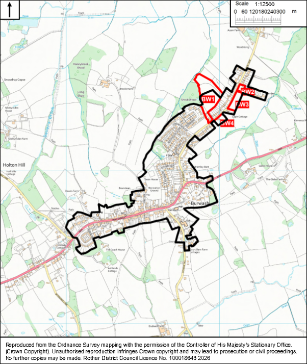
Policy BW1: Land north of Shrub Lane, Burwash Comment
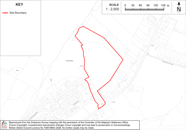
The site is allocated for residential development comprising 35 dwellings and a new area of broad-leaved woodland.
Development on this site must:
i. Provide a policy-compliant amount of on-site affordable housing in line with policy HOU2 of the Rother Local Plan;
ii. Include an area of public open space comprising (e.g. an amenity green space and a Locally Equipped Area of Play);
iii. Include new broad-leaved woodland of mixed native species of 30 meters wide to contain the new development from the north and the east;
iv. Include provision for the retention and future management of a buffer zone of semi-natural habitat, at least 15 metres wide, on the eastern boundary, between the edge of development areas and the Ancient Woodland within Shrub Wood;
v. Retain and enhance the trees and hedges that fall on the southeastern boundary between the site area and exiting ribbon development along Shrub Lane;
vi. Include a new vehicular access from Shrub Lane into the south-west corner of the site;
vii. Include new pedestrian and cycle connections to a new footway on Shrub Lane;
viii. Include the creation of a new footway along the frontage of Strand Meadow, linking the site with the bus stop to the southern end of Strand Meadow;
ix. Include a formalised footway link onto Hornbeam via existing path between 34 and 35 Hornbeam, subject to land availability;
x. Be planned to ensure future access to the existing sewerage infrastructure that crosses the site, for maintenance and upsizing purposes;
xi. Include an assessment and evaluation of the site’s archaeological potential and the implementation of any mitigation measures identified through the assessment.
14.14The site is a field to the rear of existing ribbon development along the north of Shrub Lane, towards the edge of Burwash village. It is well located in relation to services in Burwash and provides an opportunity for a small extension of the built form of the village.
14.15The site is within the Village Area Type, has a site size of 2.7 hectares and an indicative developable area of 1.1 hectares. It is allocated for some 35 dwellings at an indicative residential density of 35 dwellings per hectare.
14.16It is within the High Weald National Landscape and therefore a sensitive form of development is required in line with Local Plan policies. The developable portion of the site lies adjacent to the east of an area of Ancient Woodland and Priority Habitat known as Shrub Wood. The Ancient Woodland and Priority Habitats within and adjacent to the site are Areas of Particular Importance for Biodiversity (APIB) and Areas that Could become of Importance for Biodiversity (ACIB) that are defined and mapped in the East Sussex and Brighton & Hove Local Nature Recovery Strategy (LNRS). Any proposed scheme will therefore be required to take opportunities as part of the Biodiversity Net Gain scheme to contribute to the measures and objectives of the LNRS.
14.17There is an opportunity for the creation of a new woodland of native species within the site, providing a substantial area of green infrastructure, potential for significant Biodiversity Net Gain and a strongly defined village edge screening the site permanently in the landscape. This would form an area of new broad-leaved woodland planting of 30 meters wide to contain the new development from the north and the east, while forming an extension to the existing Shrub Wood.
14.18A previous archaeological survey identified potential remains of local archaeological interest, including a possible kiln. Consequently, further investigative work will be required.
14.19Other potential constraints include a small area of land within the eastern corner of the site that is vulnerable to surface water flooding. In addition, near to the northwest boundary of the site is a watercourse, within the catchment of the River Rother, which runs through the ancient woodland that bounds the site, which is also liable to surface water flooding, however no development is proposed in the northern end of the site.
14.20The site would require a new vehicular and pedestrian access onto Shrub Lane, including the creation of a new footway along the northern side of the road to connect to the bus stop at Strand Meadow, and to encourage active travel.
14.21Southern Water have made it known that a wastewater sewer crosses the site. Proposed layouts will need to take account of its location, including any required easements to ensure future access to existing sewerage infrastructure. Southern Water also advise that the site may have limited local network capacity, and consequently the occupation of development will need to be phased to align with the delivery of sewerage infrastructure, in consultation with Southern Water.
14.22Overhead electricity cables, including a telegraph pole, are located along the site entrance along the front of 37 and 38 Shrub Lane. Development proposals will require early engagement with the National Grid Electricity Transmission to ensure that they are safeguarded.
Policy BW2: Land at 101 Shrub Lane, Burwash Comment
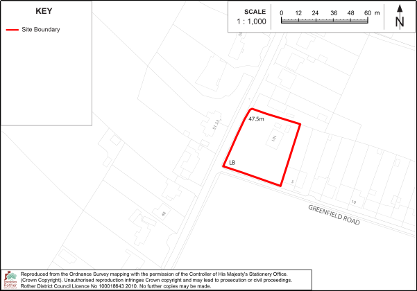
The site is allocated for residential development comprising 6 dwellings.
Development on this site must:
i. Provide a policy-compliant amount of on-site affordable housing in line with policy HOU2 of the Rother Local Plan;
ii. Retain and enhance the existing roadside hedgerows along the boundaries of Shrub Lane and Greenfield Road;
iii. Ensure that the setting of the Grade II listed buildings, 51 and 53 Shrub Lane, to the west of the site, are protected;
iv. Have regard to the historic setting and design of the former workers cottages along Greenfield Road;
v. Include vehicular and pedestrian access from Shrub Lane;
vi. Include a new public footway alongside Shrub Lane behind the existing hedgerow frontage;
vii. Be planned to ensure future access to existing sewerage infrastructure that crosses the site, for maintenance and upsizing purposes.
14.23The site comprises a single 20th century dwelling in a large plot, fronting Shrub Lane, within the built-up area of Burwash village and within the High Weald National Landscape. It provides an opportunity for redevelopment to provide a small number of additional dwellings without encroaching into the countryside or harming the High Weald National Landscape. The site is well located for services in Burwash although improvements to pedestrian infrastructure are required to encourage active travel.
14.24The site is within the Village Area Type, has a site size of 0.18 hectares. It is allocated for some 6 dwellings at an indicative residential density of 36 dwellings per hectare.
14.25 It is within the High Weald National Landscape and therefore a sensitive form of development is required in line with Local Plan policies. The policy requirements detailed above include the requirement to protect the setting of the listed buildings opposite, to the west of Shrub Lane, as well as having regard to the setting of the former workers cottages adjacent along Greenfield Road to the east. In addition, the policy requires that the existing hedgerows along Shrub Lane and Greenfield Road are retained and enhanced, which are important for the site’s rural setting.
14.26A public footway should be delivered behind the hedgerow fronting Shrub Lane, as there is likely to be insufficient space alongside Shrub Lane itself. The footway should align with the corresponding footway as part of neighbouring allocation BW3 so that the continuation of the footway through each site is easily visible for users.
14.27 A Southern Water wastewater sewer crosses the site, just within its frontage with Shrub Lane. Proposed layouts will need to take account of its location, including any required easements to ensure future access to existing sewerage infrastructure.
14.28 Overhead electricity cables run along the site’s frontage with Greenfield Road. Development proposals will require early engagement with the National Grid Electricity Transmission to ensure that they are safeguarded.
Policy BW3: Land east of Shrub Lane (north), Burwash Comment
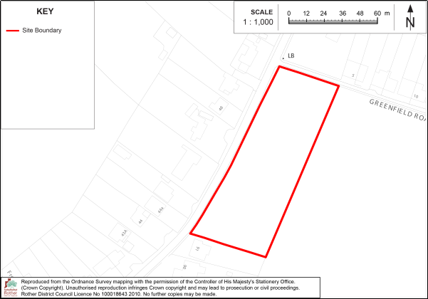
The site is allocated for residential development comprising 15 dwellings.
Development on this site must:
i. Provide a policy-compliant amount of on-site affordable housing in line with policy HOU2 of the Rother Local Plan;
ii. Provide vehicular parking for the dwellings through a shared use surface to the rear of the dwellings (within the site boundary) with a new vehicular access onto Shrub Lane;
iii. Provide active travel access via an appropriate path behind the hedgerow frontage;
iv. Provide an additional pathway to the rear of the site, leading southwards and then westwards from the site’s eastern boundary, to connect to the land subject to site allocation policy BW4 and then further south-westwards to connect to the existing footway alongside Shrub Lane by Morris Close;
v. Provide a new hedgerow along the site’s eastern boundary;
vi. Retain and enhance the existing boundary hedgerow along Shrub Lane, except for any short sections which need to be removed to facilitate access which should be minimised as far as possible;
vii. Be laid out to ensure future access to existing sewerage infrastructure that crosses the site, for maintenance and upsizing purposes;
viii. Have regard to the setting and design of the former workers cottages along Greenfield Road;
ix. Include any necessary off-site highway works necessary to make the development acceptable.
14.29The site comprises the roadside portion of an open field on the north-eastern edge of Burwash village with a hedgerow frontage. It provides an opportunity to sensitively extend the existing ribbon development along Shrub Lane, together with site allocation Policy BW4. It is important that development is limited to within the site area (other than a sensitively designed pedestrian path to link south-westwards), as encroachment into the wider field would be harmful to the landscape within the High Weald. Hence, the development boundary is drawn tightly around the south-eastern edge of the site.
14.30The site is within the Village Area Type, has a site size of 0.59 hectares. It is allocated for some 15 dwellings at an indicative residential density of 25 dwellings per hectare.
14.31 It is within the High Weald National Landscape and therefore a sensitive form of development is required in line with Local Plan policies. The roadside boundary hedgerow will need to be retained and the setting of the former workers cottages along Greenfield Road to the north should be respected. These features are important components of the area’s rural setting, while the site itself is located within a medieval assart. To this extent, development must not extend beyond the depth of the existing ribbon development, which is reflected in the mapped site area. A new hedgerow is required on the site’s eastern boundary to provide a clear edge to the development and prevent encroachment into the wider field.
14.32An appropriately designed pathway would need to be provided along the frontage, behind the hedgerow, to improve safety for active travel users (who currently utilise the carriageway on Shrub Lane). The Highway Authority have advised that the hedge height would need to be maintained at a sufficiently low level, while any footway behind the hedge would need to be visible to drivers using the site access. The path should align with the corresponding path provided as part of neighbouring allocation BW4 so that the continuation of the footway through each site is easily visible for users. The policy also includes a requirement for an additional, sensitively designed pathway, using a permeable surface, to be provided to the rear of the site to link to site BW4, and then to continue to the rear of the existing ribbon development to the southwest in order to connect to the footway along Shrub Lane through an undeveloped passage at Morris Close. This is required due to the lack of footways along this stretch of Shrub Lane, which the Highway Authority have advised is also too narrow to provide a new roadside footway here. This will provide active travel accessibility, for this site as well as existing residential development along this section of Shrub Lane, while enhancing public accessibility to the surrounding countryside.
14.33Vehicular parking will need to be provided through a shared use surface to the rear of the dwellings (within the site area), connecting to Shrub Lane via a new vehicular access through a minimal portion of the hedgerow frontage. Further measures to improve pedestrian accessibility and safety may also be required, subject to the advice of the Highway Authority.
14.34Site screening has identified that parts of the site are at risk from surface water flooding and this will need taking into account in the detailed design.
14.35A Southern Water wastewater sewer crosses the site, just within its frontage with Shrub Lane. Proposed layouts will need to take account of its location, including any required easements to ensure future access to existing sewerage infrastructure.
Policy BW4: Land east of Shrub Lane (south), Burwash Comment
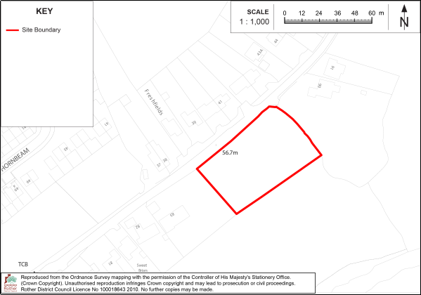
The site is allocated for residential development comprising 8 dwellings.
Development on this site must:
i. Provide a policy-compliant amount of on-site affordable housing in line with policy HOU2 of the Rother Local Plan;
ii. Provide vehicular parking through a shared use surface to the rear of the dwellings (within the site boundary) with a new vehicular access onto Shrub Lane;
iii. Provide active travel access via an appropriate path behind the hedgerow frontage;
iv. Provide an additional pathway to the rear of the site, to connect to site allocation BW3 and to the existing footway alongside Shrub Lane by Morris Close;
v. Provide a new hedgerow along the site’s eastern boundary;
vi. Retain and enhance the existing boundary hedgerows and trees along Shrub Lane and the site’s northeastern boundary, except for any short sections which need to be removed to facilitate access which should be minimised as far as possible;
vii. Be laid out to ensure future access to existing sewerage infrastructure that crosses the site, for maintenance and upsizing purposes;
viii. Include any necessary off-site highway works necessary to make the development acceptable.
14.36The site comprises the roadside portion of an open field on the north-eastern edge of Burwash village with a hedgerow frontage. It provides an opportunity to sensitively extend the existing ribbon development along Shrub Lane, together with site allocation Policy BW3. It is important that development is limited to within the site area (other than a sensitively designed pathway to link south-westwards and north-eastwards), as encroachment into the wider field would be harmful to the landscape within the High Weald. Hence, the development boundary is drawn tightly around the south-eastern edge of the site.
14.37The site is within the Village Area Type, has a site size of 0.32 hectares. It is allocated for some 8 dwellings at an indicative residential density of 25 dwellings per hectare.
14.38It is within the High Weald National Landscape and therefore a sensitive form of development is required in line with Local Plan policies. The roadside boundary hedgerow will need to be retained as an important component of the area’s rural setting, while the site itself is located within a medieval assart. To this extent, development must not extend beyond the depth of the existing ribbon development, which is reflected in the mapped site area. A new hedgerow is required on the site’s south-eastern boundary to provide a clear edge to the development and prevent encroachment into the wider field.
14.39An appropriately designed pathway would need to be provided along the frontage, behind the hedgerow, to improve safety for active travel users (who currently utilise the carriageway on Shrub Lane). The Highway Authority have advised that the hedge height would need to be maintained at a sufficiently low level, while any footway behind the hedge would need to be visible to drivers using the site access. The path should align with the corresponding path provided as part of neighbouring allocation BW3 so that the continuation through each site is easily visible for users. The policy also includes a requirement for an additional, sensitively designed pathway, using a permeable surface, to be provided to the rear of the site to link to site BW3 to the northeast, while continuing to the rear of the existing ribbon development to the southwest in order to connect to the footway along Shrub Lane through an undeveloped passage at Morris Close. This is required due to the lack of footways along this stretch of Shrub Lane, which the Highway Authority have advised is also too narrow to provide a new roadside footway here. This will provide active travel accessibility, for this site as well as existing residential development along this section of Shrub Lane, while enhancing public accessibility to the surrounding countryside.
14.40Vehicular parking will need to be provided through a shared use surface to the rear of the dwellings (within the site boundary), connecting to Shrub Lane via a new vehicular access through a portion of the hedgerow frontage. Further measures to improve pedestrian accessibility and safety may also be required, subject to the advice of the Highway Authority.
14.41 Site screening has identified that parts of the site are at risk from surface water flooding and this will need taking into account in the detailed design.
14.42A Southern Water wastewater sewer crosses the site. Proposed layouts will need to take account of its location, including any required easements to ensure future access to existing sewerage infrastructure.
14.43 Overhead electricity cables run along the site’s frontage with Shrub Lane. Development proposals will require early engagement with the National Grid Electricity Transmission to ensure that they are safeguarded.
Burwash Common
Parish: Burwash
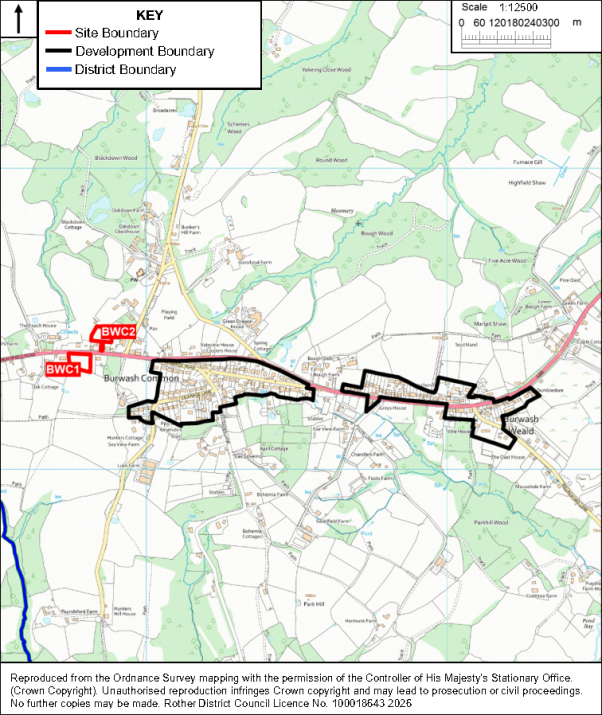
Policy BWC1: Land south of Heathfield Road, Burwash Common Comment
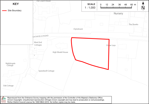
The site is allocated for residential development comprising 7 dwellings.
Development on this site must:
i. Provide a policy-compliant amount of on-site affordable housing in line with policy HOU2 of the Rother Local Plan;
ii. Include no development within the southern part of the site, which will form an area of green infrastructure;
iii. Retain and enhance the trees and hedgerows that form all site boundaries, most notably the historic field boundaries to the north, south and west, save for any removal on the roadside boundary hedgerow necessary to facilitate a safe access point;
iv. Create a new boundary hedge to define the site’s eastern boundary and separate it from the remaining section of field outside the site;
v. Take account of the risk of surface water flooding in the northwestern part of the site;
vi. Include vehicular access onto the A265;
vii. Include appropriate pedestrian infrastructure inside and outside the site to link to the southern side of the A265;
viii. Include improvements to the existing footway outside the site.
14.44This is a small field on the edge of Burwash Common adjacent to the south of the A265. The site sits between and opposite roadside residential development, with a row of trees forming the southern boundary. The site slopes gradually up in the direction of the ridgeline beyond the site further to the south.
14.45The site is within the Village Area Type, has a site size of 0.36 hectares and an indicative developable area of 0.2 hectares. It is allocated for some 7 dwellings at an indicative residential density of 35 dwellings per hectare.
14.46 Burwash Common is a settlement with limited services, however the site is close to bus stops on the A265, and the village hall and recreation ground are within walking distance. The closest primary school is in Burwash, 3.5km to the north-east along the A265, with the town of Heathfield being just over 5km to the west. Stonegate Railway station is the nearest train access, at just over 4km to the north. Connections to the existing footway infrastructure to encourage active travel are required, as detailed above.
14.47It is within the High Weald National Landscape and therefore a sensitive form of development is required in line with Local Plan policies. Much of Burwash Common occupies part of an important ridgeline within the National Landscape, although this site sits topographically lower than adjacent areas of the village to the east, with the southern tree boundary and higher fieldscape forming the ridgetop further to the south.
14.48In landscape terms there is scope for a small number of dwellings fronting the main road that retains the existing hedge and tree frontage, with an access road between the site boundary and dwellings to the south, without harming the character of the National Landscape. It will be important that the southern areas of the site that are topographically higher are not developed in order to protect long distance landscape views from the north.
14.49The site is wholly within an Area that Could become of Importance for Biodiversity (ACIB) that is defined and mapped in the East Sussex and Brighton & Hove Local Nature Recovery Strategy (LNRS). Any proposed scheme will therefore be required to take opportunities as part of the Biodiversity Net Gain scheme to contribute to the measures and objectives of the LNRS, within the southern undeveloped part of the site. Other environmental constraints include an area within the northwestern corner of the site that is at risk of surface water flooding.
14.50The site’s existing access point is within a 40mph stretch of the A265, while the speed limit rises to 50mph east of the site’s western boundary. The delivery of vehicular and pedestrian access will therefore require consultation with the Highway Authority. Improvements to pedestrian infrastructure outside the site, as required through the policy, will encourage opportunities for active travel.
14.51Overhead electricity cables run along the site’s frontage with the A265. Development proposals will require early engagement with the National Grid Electricity Transmission to ensure that they are safeguarded.
Policy BWC2: Old Orchard Nursery, Heathfield Road, Burwash Common Comment
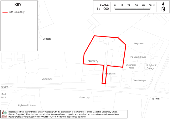
The site is allocated for residential development comprising 9 dwellings.
Development on this site must:
i. Provide a policy-compliant amount of on-site affordable housing in line with policy HOU2 of the Rother Local Plan;
ii. Include vehicular access onto the A265;
iii. Include appropriate pedestrian infrastructure inside and outside the site to link to the northern side of the A265;
iv. Retain the trees that are located along the site’s eastern, northern and western boundaries.
14.52This is an enclosed site located in Burwash Common north of the A265. The site was previously part of a plant and tree nursery but now forms vacant land that lies to the rear of the remaining sections of the business. It is considered suitable for a small residential development of some 9 dwellings.
14.53The site is within the Village Area Type, has a site size of 0.3 hectares. It is allocated for some 9 dwellings at an indicative residential density of 30 dwellings per hectare.
14.54 It is within the High Weald National Landscape and therefore a sensitive form of development is required in line with Local Plan policies. The site is a well contained, infill site with developed areas to the south, the east and northeast, while trees provide dense screening to the west, north and east. For this reason, it is important that these boundary trees are retained.
14.55Given the site’s former use, there is an existing access onto a wide layby alongside the A265. Necessary visibility splays will need to be determined in conjunction with the highway authority. The site is also served by an existing pedestrian footway that connects to a bus stop some 130m beyond the junction to the east. Connections to the existing footway infrastructure to encourage active travel are required, as detailed above.
Etchingham
Parish: Etchingham
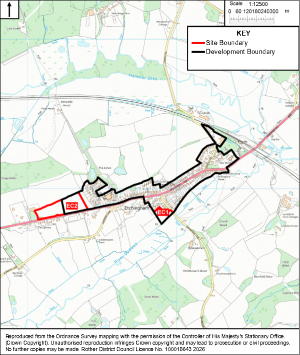
Policy EC1: Land at Oxenbridge Lane, Etchingham Comment
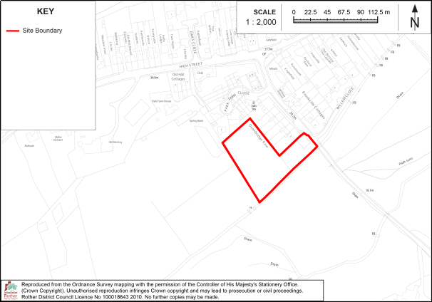
The site is allocated for residential development comprising some 10 new dwellings.
Development on this site must:
i. Provide a policy-compliant amount of on-site affordable housing in line with policy HOU2 of the Rother Local Plan;
ii. Retain the southern part of the site (within flood zones 2 or 3) as green infrastructure (excepting requirements for vehicular access via Oxenbridge Lane to the east and public car parking);
iii. Be carried out in accordance with the recommendations of a Flood Risk Assessment (FRA) across the site;
iv. Include a vehicular access from Oxenbridge Lane;
v. Include appropriate pedestrian infrastructure inside and outside the site to link to the western side of Oxenbridge Lane;
vi. Be designed sensitively, having particular regard to the landscape setting of the nearby River Dudwell;
vii. Retain the site’s western boundary hedgerow;
viii. Provide space for public car parking within the site to replace the loss of existing parking in the public car park on Oxenbridge Lane;
ix. In consultation with the Environment Agency, ensure that the development does not have an adverse effect on the integrity of the tidal flood defences and tidal outfall; and that access to the defences and outfall is maintained, and where possible, improved, in order to allow for inspection, maintenance and future improvements to the defences and outfall;
x. Be planned to ensure future access to existing sewerage infrastructure that crosses the site, for maintenance and upsizing purposes.
14.57The site lies on the southern edge of Etchingham village within the High Weald National Landscape. It comprises a small field behind existing dwellings at Oxenbridge Row and a small Council-owned public car park at the end of Oxenbridge Lane which would provide vehicular and pedestrian access. Connections to the existing footway infrastructure to encourage active travel are required, as detailed above. It provides an opportunity for a logical, small extension to the built form of the village, in a sustainable location within walking distance of village services including the primary school and mainline railway station.
14.58The site is within the Village Area Type, has a site size of 0.61 hectares and an indicative developable area of 0.29 hectares. It is allocated for some 10 dwellings at an indicative residential density of 35 dwellings per hectare.
14.59The site lies north of the River Dudwell[11] and the southern half of the site, including its access from Oxenbridge Lane is within Flood Zone 2, while its south-eastern boundary adjacent to the river, is in Flood Zone 3. There is limited land within Etchingham village that is not affected by flooding or other environmental constraints. For flood risk reasons, built development should be located within the higher, northern part of the site to the rear of Oxenbridge Row and a safe access will need to be demonstrated. Sustainable Drainage features will be required on site to not increase the risk of nearby flooding. An emergency access may also need to be considered although this may be reliant on third-party land.
14.60In relation to the adjacent Dudwell River, the Environment Agency has identified the presence of defences within and/or near to the site.
14.61Southern Water has identified that its infrastructure crosses the site and may require easements or diversion, which will need to be reflected in the site layout.
Policy EC2: Croft Field, Etchingham Comment
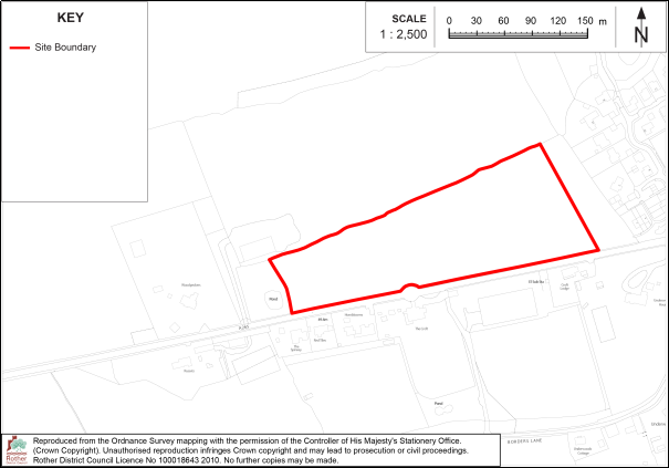
The site is allocated for residential development comprising some 30 dwellings.
Development on this site must:
i. Provide a policy-compliant amount of on-site affordable housing in line with policy HOU2 of the Rother Local Plan;
ii. Include a significant area of Green Infrastructure across the western two-thirds of the site, including biodiversity net gain and habitat enhancements that protect and enhance the existing wildflower meadow and good quality semi-improved grassland Priority Habitat within the site;
iii. Limit built development to the eastern part of the site closest to Parsonage Croft;
iv. Provide vehicular and pedestrian access via the southeastern end of the site onto the A265;
v. Provide a new footway along the northern side of the A265 from the site access to connect eastwards to Parsonage Croft;
vi. Include any necessary off-site highway works and interventions necessary to make the development acceptable;
vii. Retain and enhance the hedgerows that form the southern, northern and western site boundaries, which are historic field boundaries, and supplement the northern site boundary with additional tree planting;
viii. Include an appropriate buffer between the site and the recently planted woodland to the east, as informed by a tree survey;
ix. Make an acceptable connection to the local sewerage system and ensure necessary capacity before occupation, in liaison with the service provider; and
x. Where necessary, relocate the overhead power cables in accordance with the requirements of UK Power Networks.
14.62The site is a linear agricultural field that lies on the northern side of the A265, west of an area of recently planted woodland and grassland associated with the adjacent development at Parsonage Croft at the westernmost extent of Etchingham village. The field is formed by historic field boundaries to the north, west and south. It is located within a sustainable location, with the primary school and village hall nearby to the east.
14.63The site is within the Village Area Type, has a site size of 3.05 hectares and an indicative developable area of 1 hectare. It is allocated for some 30 dwellings as an indicative residential density of 30 dwellings per hectare.
14.64 It is within the High Weald National Landscape and therefore a sensitive form of development is required in line with Local Plan policies. The site is relatively well screened within the wider landscape, being bound by woodland to the west, recent residential development and associated planting to the east, and a treeline along the ridgeline to the north. The roadside (southern) boundary is less well screened but defined by a hedgerow.
14.65Development would need to retain and enhance the existing boundary hedgerows, while a buffer will be required between the site’s developable area and the recently planted woodland that bounds the site to the east. The existing treeline and hedgerow along the northern boundary should be retained and reinforced through additional tree planting in order to strengthen the site's containment within the landscape and maintain the ridgeline character of the site.
14.66The site forms an area of good quality semi-improved grassland Priority Habitat, which is identified by the High Weald dataset as being wildflower meadow. It has been identified by the East Sussex Local Nature Recovery Strategy as an Area that Could become of Potential Importance for Biodiversity (ACIB). Consequently, a significant portion of the site will need to be left undeveloped as Green Infrastructure with an emphasis on biodiversity net gain and enhancement of the wildflower meadow to be maintained in perpetuity. Moreover, the western end of the site is more visible to countryside views from the south, meaning that development should be concentrated in the eastern section. Development of only the eastern third of the site would ensure that views across the site to the northern tree boundary are maintained. In any event, the layout and detailed design will need to be informed by a detailed landscape and visual impact assessment and ecological surveys.
14.67The site lies alongside a section of the A265 that operates the national speed limit, being just west of the 30mph zone that runs through the village. Initial comments from ESCC Highways indicate that the site’s development may require the westward extension of the 30mph zone from its current start point. Pedestrian connectivity to the nearby school and the remainder of the village will require the provision of a new short stretch of footway along the northern side of the A265 from the southeastern end of the site to connect to the footway at the front of Parsonage Croft, across third party land.
14.68While there are no known notable surface water flooding issues within its boundary, the site slopes from its northern edge down to the southern boundary with the A265, and any proposals would need to ensure that development does not increase the risk of flooding onto the A265. Furthermore, it is understood there are concerns with sewerage capacity locally. The developer will need to work with Southern Water to ensure appropriate sewerage infrastructure is provided to serve the development prior to its occupation.
14.69Overhead electricity cables run along part of the site’s frontage with the A265. Development proposals will require early engagement with the National Grid Electricity Transmission to ensure that they are safeguarded.
Hurst Green
Parish: Hurst Green
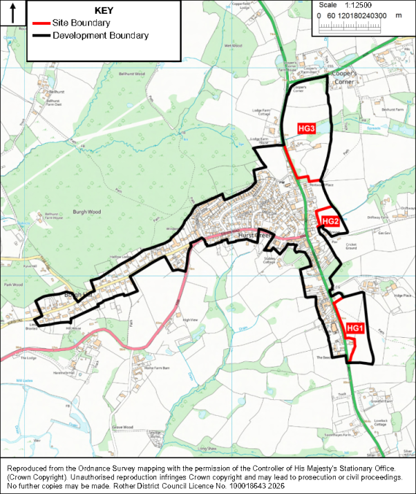
Policy HG1: Land south of Iridge Place, London Road, Hurst Green Comment
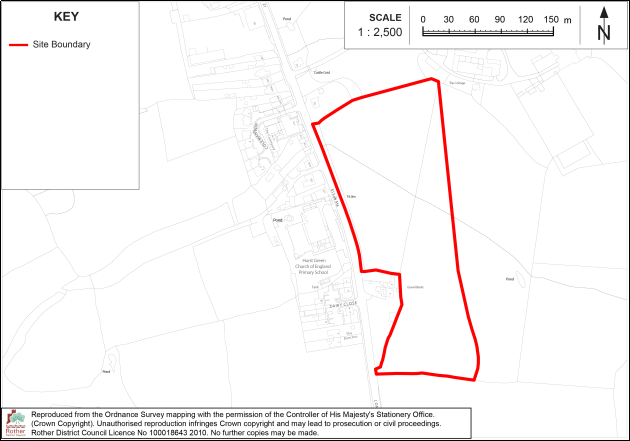
The site is allocated for residential development comprising 28 dwellings and Public open space (village green) of 1.35ha
Development on this site must:
i. Provide a policy-compliant amount of on-site affordable housing in line with policy HOU2 of the Rother Local Plan;
ii. Provide a new village green, including community car parking area for those using the new village green;
iii. Provide for a drop-off point for the primary school and an associated crossing on the A21;
iv. Include vehicular and pedestrian access, including Travel Plan(s) and internal road layout, as agreed with the relevant highway authorities;
v. Retain Public Footpath Hurst Green 29;
vi. Be designed to ensure that the residential amenity of future occupiers is protected from any environmental impacts arising from the site’s proximity to the A21 (including noise), and incorporate necessary mitigation measures;
vii. Be designed to protect the setting of the adjacent and nearby listed buildings;
viii. Include the retention of the ancient and/or veteran tree in the southeast corner of the site, including necessary buffers to development;
ix. Include an assessment and evaluation of the site’s archaeological potential and the implementation of any mitigation measures identified through the assessment.
14.70The site comprises a large linear section of a field on the eastern side of London Road (the A21 trunk road), in the southern part of Hurst Green village. The site is subject to a planning permission for 28 dwellings, a new village green, a community car park, and drop-off and crossing facility to serve the nearby primary school which has not yet been implemented. This also carries forward an allocation in the Hurst Green Neighbourhood Development Plan.
14.71The site has some environmental constraints, including nearby listed buildings and its location within the High Weald National Landscape and an Archaeological Notification Area. A sensitive, well-designed scheme is therefore required, and the policy criteria reflect the requirements of the planning permission. A section within the west of the site is covered by an Area that Could be of Importance to Biodiversity (ACIB) that is defined and mapped in the East Sussex and Brighton & Hove Local Nature Recovery Strategy (LNRS). In addition, there is an ancient and/or veteran tree mapped in the south-east corner of the allocation. Any proposed scheme will therefore be required to take opportunities as part of the Biodiversity Net Gain scheme to contribute to the measures and objectives of the LNRS. Other constraints include an Archaeological Notification Area (ANA) is slightly within the northeast of the site, while a smaller ANA is adjacent to the west of the site.
14.72Vehicular access onto the A21 (part of the Strategic Road Network) will be required. The location and form of access(es) will need to be determined in consultation with National Highways. A Transport Assessment will need to be demonstrated that the new site access will need to be fully assessed in line with the relevant guidance set out in DfT Circular 01/2022, the Design Manual for Roads and Bridges (DMRB) and Stage 1 Road Safety Audit (RSA), Walking, Cycling and Horse-riding Assessment and Review (WCHAR) etc. As the site abuts the A21, consultation will also be necessary for any boundary issues, including drainage, lighting, geotechnical, boundary treatments.
Policy HG2: Land to Rear of The Olde Bakery, London Road, Hurst Green Comment
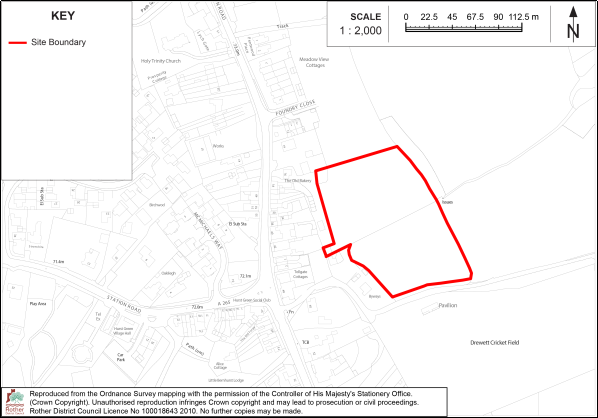
The site is allocated for residential development comprising 25 dwellings.
Development on this site must:
i. Provide a policy-compliant amount of on-site affordable housing in line with policy HOU2 of the Rother Local Plan;
ii. Avoid development in areas most at risk of surface water flooding within the centre of the site;
iii. Retain and enhance the existing hedgerow and trees bounding the site, most significantly along the eastern site boundary;
iv. Retain the stream/ditch historic field boundary that sub-divides the two lower fields, and which is also to be incorporated within the layout as an area of green infrastructure;
v. Include a vehicular access from Pringle Close to the north;
vi. Include appropriate pedestrian infrastructure inside and outside the site to link to the footway on London Road, via Foundry Close and Pringle Close;
vii. Include additional active travel connection to the A21 via the southwest corner of the site (along existing footpath 31);
viii. Include any necessary off-site highway works necessary to make the development acceptable, and:
ix. Be planned to ensure future access to existing sewerage infrastructure that crosses the site, for maintenance and upsizing purposes;
x. Include an assessment and evaluation of the site’s archaeological potential and the implementation of any mitigation measures identified through the assessment.
14.73The site comprises two adjoining fields, east and to the rear of existing roadside development fronting London Road (which is part of the Strategic Road Network), within Hurst Green village. The site is relatively enclosed by boundary trees and hedges, and it provides an opportunity for additional dwellings in a sustainable location within the village.
14.74The site is within the Village Area Type, has a site size of 1.43 hectares and an indicative developable area of 0.72 hectares. It is allocated for some 25 dwellings at an indicative residential density of 32 dwellings per hectare.
14.75It is within the High Weald National Landscape and therefore a sensitive form of development is required in line with Local Plan policies. The site contains High Weald character features including intact historic field boundaries.
14.76 The central historic field boundary, which forms a hedgerow and ditch, bisecting the site is also an area that is vulnerable to surface water flooding which builds to the east, extending then further to the countryside to the east. The hedgerow and ditch should therefore be retained as far as possible (allowing for a necessary access through), while forming the centre of a new area of Green Infrastructure. Sustainable drainage features will be required on site not to increase the risk of flooding. Additional planting will be required to further screen the site from the countryside to the east, and to form a buffer to vegetation along the central field boundary and along the external boundaries.
14.77In order to achieve the allocated number of dwellings while retaining the identified National Landscape features within the site, proposals should comprise a compact, terraced layout, reflective of the adjoining Pringle Close development, which accords with the Live Well Locally policies and the High Weald Housing Design Guide.
14.78The site is currently overgrown and is likely to accommodate wildlife habitats and potentially protected species. Up-to-date ecological surveys and tree surveys will be required to inform development.
14.79A wastewater pipe belonging to Southern Water is located just within the western boundary in the northern half of the site, which will also need to inform the site design and layout.
14.80Adjoining the site to the north is a recently constructed housing development which is accessed via an extension to Foundry Close. Vehicular access will need to come through this development, via Pringle Close and Foundry Close as there is not an opportunity to provide a safe vehicular access to the south of site. It is understood there is in-principle landowner agreement to this access arrangement.
14.81Access onto the A21 will need to be subject to a highways assessment to the approval of National Highways to ensure the proposed development does not adversely impact upon the A21. Any upgraded or improvement of the existing access onto the A21 from Foundry Close would need to be fully assessed in line with the relevant guidance set out in DfT Circular 01/2022 and DMRB.
14.82Pedestrian infrastructure will be required through the site and will require a pedestrian access at the site’s southern end to join up with the existing public footpath and onto the A21, to encourage active travel. The provision of additional bus stops may be required. National Highways also advise that there are currently no formalised pedestrian crossing points within the vicinity of the site. As such, they state that formalised pedestrian crossings, including dropped kerbs and tactile paving, should also be considered to provide safe and accessible links to any new bus stops and to improve overall pedestrian connectivity in the area.
Policy HG3: Land at The Lodge, London Road, Hurst Green Comment
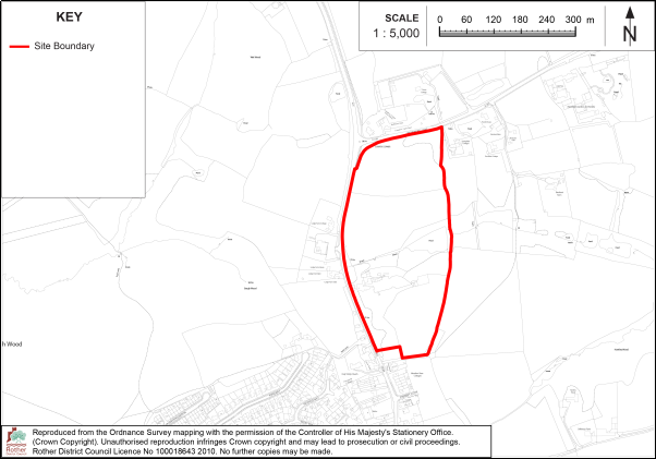
The site is allocated for residential development comprising:
- Some 150 new dwellings;
- Ancillary use(s) subject to community or local economic needs, which may include community, employment, leisure or small-scale convenience retail;
- A Local Equipped Area for Play (LEAP) of at least 400sqm (0.04ha);
- Some 4.7ha of Green Infrastructure.
Development on this site must:
- Provide a policy-compliant amount of on-site affordable housing in line with policy HOU2 of the Rother Local Plan;
- Provide ancillary use(s) to serve community or local economic needs;
- Retain The Lodge as a non-designated heritage asset within the site layout;
- Retain and protect the existing watercourse and lake in the centre of the site and provide an appropriate buffer to any built development including roadways;
- Include significant areas of Green Infrastructure (with public access provided where appropriate) across some 50% of the site area, notably including the central area containing an existing watercourse and lake.
- Include provision for the retention and future management of a buffer zone of semi-natural habitat, at least 15 metres wide, on the eastern boundary, between the edge of development and the Ancient Woodland;
- Be informed by a tree survey and layout which seeks to retain existing mature trees within the site where possible, having regard to incorporation of the site’s parkland features;
- Retain and enhance existing hedgerows and trees bounding the site, including the provision of additional planting on the eastern boundary of the site to create a strongly defined village edge screening the site in the National Landscape;
- Provide suitable vehicular and active travel access to serve the development, to be determined in consultation with National Highways, having regard to the operation and safety of the Strategic Road Network, the setting of nearby heritage assets, and the conservation of the National Landscape;
- Include appropriate active travel infrastructure inside and outside the site in accordance with the policies in this Local Plan, to enable improved pedestrian and cycle connections north-southwards to the A229;
- Include an eastern boundary pedestrian connection to the footpath east of the site: public right of way “Hurst Green 33”.
- Include any necessary off-site highway works necessary to make the development acceptable, including traffic and infrastructure improvements to the A21 and the A229, where required;
- Occupation of development will be phased to align with the delivery of sewerage infrastructure, in consultation with the service provider.
14.83The site comprises fields and associated outbuildings that form the private estate of a large residential dwelling and non-designated heritage asset known as ‘The Lodge’, totalling nearly 10 hectares. It has a parkland character containing mature trees and hedgerows. The site extends adjacent to and along the eastern side of the A21 which is part of the Strategic Road Network, between Pentwood Place to the junction with the A229 to the north of the village.
14.84The site is within the Village Area Type, has a site size of 9.52 hectares and an indicative developable area of 4.8 hectares. It is allocated for some 150 dwellings at an indicative residential density of 35 dwellings per hectare.
14.85In addition to providing new housing within walking distance of the village centre, development also provides an opportunity to provide complementary, non-residential development, potentially including community and/ or economic uses, to improve local services and facilities. The exact form of such development would be for determination at planning application stage and should be subject to consultation with the Parish Council and informed by an assessment of local needs. A community hall, for example, may not be necessary given the existing provision on Station Road but a multifunctional building which could accommodate uses such as a children’s nursery, medical uses or flexible workspace, together with a neighbourhood retail element and transport hub could be appropriate, or potentially small, class E units. In addition, a LEAP will be required.
14.86The site also offers the opportunity to provide safer and more attractive active links within the site, between the village and the A229, to encourage active travel. The existing non-designated heritage asset, the Lodge, should be retained and incorporated any proposed development as integral to the site’s parkland setting.
14.87While the site would represent a northwards extension to the village, it is generally well enclosed within the wider High Weald landscape, protecting longer views. However, the allocation is likely to be considered major development in the HWNL, meaning that securing appropriate mitigation and public benefit would be fundamental. This scale of development is justified, given the site’s proximity to village services and the need to provide housing.
14.88The site is bound to the west and north by the A21 and A229 respectively, while its border with the countryside to the east is well defined by trees and hedgerows, which offer screening and also forms a historic field boundary along the southern half of the east facing boundary. This boundary would be retained and enhanced to protect views from the open fieldscape beyond to the east. There is a small area of woodland within the eastern boundary, which is identified as a Priority Habitat and an Area that Could be of Importance for Biodiversity, as defined and mapped in the East Sussex and Brighton & Hove Local Nature Recovery Strategy (LNRS). There is also an area of Ancient Woodland adjacent to the eastern boundary that is defined as an Area that is of Particular Importance to Biodiversity (APIB) in the LNRS. Any proposed scheme will therefore be required to take opportunities as part of the Biodiversity Net Gain scheme to contribute to the measures and objectives of the LNRS. Lighting for the development will need to be designed with reference to the High Weald National Landscape Unit’s Technical Advice Note on Dark Skies in the High Weald.
14.89There is a watercourse that flows west to east through the site’s centre, and into a small lake that abuts ancient woodland at the site’s eastern boundary, before it continues an eastward path down through the Kent Ditch catchment[12]. The area around the lake within the site is densely planted with trees, while the immediate area is vulnerable to surface water flooding. This area should form part of the site’s Green Infrastructure, with the potential to deliver a landscaped belt of public open space. The site layout should also create a pedestrian connection to public right of way “Hurst Green 33”, footpath to the south and east of the site, to connect residents to the surrounding countryside. Overall, the site’s parkland setting presents an opportunity to incorporate existing features and the use of Green Infrastructure to create a distinctive and high-quality development in accordance with Policy LWL5.
14.90 In relation to the site’s High Weald setting, there are Grade II listed farm buildings adjacent to the north on the other side of the A229 at Cooper’s Corner, comprising Cooper's Corner Farmhouse & Cooper's Farm Oast and Bellhurst Oast. The setting of these heritage assets will need to be an integral consideration as part of any site design with a view to the preservation of their rural context.
14.91 Southern Water’s initial checks indicate that the site may have limited local network capacity, and phasing of development may therefore be needed alongside network reinforcement prior to occupation of the total number of dwellings.
14.92The location and form of access(es) or associated junctions will need to be determined in consultation with National Highways. Any proposed upgrade/improvement of an existing SRN access will need to be fully assessed in line with the relevant guidance set out in DfT Circular 01/2022, the Design Manual for Roads and Bridges (DMRB) and Stage 1 Road Safety Audit (RSA), Walking, Cycling and Horse-riding Assessment and Review (WCHAR) etc. The preferred access solution should be informed not only by considerations of highway safety and network operation, but also by its effects on the setting of nearby listed buildings, the retention of important landscape features, and the conservation and enhancement of the High Weald National Landscape. As the site abuts the A21, consultation with the National Highways will also be necessary for any works to the boundary.
14.93The primary active travel access should be included towards the southern end of the site to link towards the village centre. Early comments from National Highways indicate that A21 crossing points should be considered within the vicinity of the pedestrian site access, as well as the implementation of new bus stops, which are otherwise situated some 300m to the south at present. Development at this scale would also be required to make any necessary off-site road infrastructure improvements, to be determined in consultation with National Highways and the Parish Council.
14.94An east to west overhead electricity line runs along and within the northern site boundary, which will need to be safeguarded, and therefore early engagement will be required with the National Grid Electricity Transmission.
Robertsbridge
Parish: Salehurst & Robertsbridge
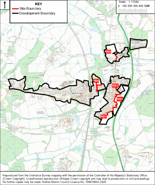
Policy RB1: Land south of Heathfield Gardens, Robertsbridge Comment
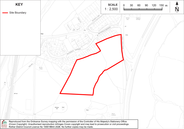
The site is allocated for residential development comprising 55 dwellings.
Development on this site must:
i. Provide a policy-compliant amount of on-site affordable housing in line with policy HOU2 of the Rother Local Plan
ii. Retain and enhance the existing hedgerows and trees bounding and subdividing the site, including those corresponding to historic field boundaries within the eastern half of the site area, and the “Locally important trees and hedgerows outside the Conservation Area” as designated through the Salehurst and Robertsbridge Neighbourhood Plan;
iii. Create a new landscape buffer along the western part of the southern boundary, to the wider field to the south;
iv. Include vehicular access from George Hill in the northeast of the site in accordance with requirements of the Highway Authority.
v. Include appropriate pedestrian infrastructure inside and outside the site to link to footways on the western side of George Hill and the southern side of Heathfield Gardens;
vi. Include any necessary off-site highway works necessary to make the development acceptable;
vii. Include an assessment and evaluation of the site’s archaeological potential and the implementation of any mitigation measures identified through the assessment.
14.95The site comprises two separate but contiguous fields on the western side of George Hill, in the southern part of Robertsbridge village. The site slopes up from north to south. The northern portion of the site, including a section of both fields, carries forward an allocation in the Salehurst and Robertsbridge Neighbourhood Plan. The new site area extends the site southward further into the western field and provides an opportunity for further residential development and Biodiversity Net Gain in this sustainable location.
14.96The site is within the Village Area Type, has a site size of 2.7 hectares and an indicative developable area of 1.57 hectares, with the remaining 1.13 hectares to provide areas of Green Infrastructure. It is allocated for some 55 dwellings at an indicative residential density of 35 dwellings per hectare.
14.97The site is within the High Weald National Landscape, and a sensitive form of development is required to protect landscape character and also biodiversity. The western field within the site is open agricultural land, and development here would need to be sensitive to the site’s rural setting, sitting below the topographical ridge to the south of the site. Edge locations should feature a reduced development density to provide a softer edge between the site and the surrounding countryside. The policy also requires the creation of a new landscape buffer to the wider field along the southern boundary to the western field, while trees and hedgerows that bound the overall site area will also require buffers to development that will form areas of Green Infrastructure and Biodiversity Net Gain. Particular regard should be had to preserving, as far as possible, the north-south belt of trees that subdivides the northern part of the site which also forms a historic field boundary. This will be important to maintain the landscape structure and character of the area.
14.98The site will require a new access to the northeast onto George Hill, while active travel connections will also be required to Heathfield Gardens. Improved crossing points should be incorporated on George Hill, as appropriate, to enhance the safety and usability of the pedestrian environment while encouraging active travel. East Sussex County Council have also recommended that bus service contributions are likely to be required.
14.99In relation to vehicular access, the site’s proximity to the A21 means that a Transport Assessment will be necessary to consider impact on the nearby junction in compliance with DfT Circular 01/2022. Furthermore, as the site abuts the A21, development proposals would need to consider any boundary issues in consultation with National Highways.
14.100An Archaeological Notification Area that covers the historic core of the village is located some 150m to the north.
14.101Overhead electricity cables run east-west through the northern end of the site. Development proposals will require early engagement with the National Grid Electricity Transmission to ensure that they are safeguarded.
Policy RB2: Grove Farm, Robertsbridge Comment
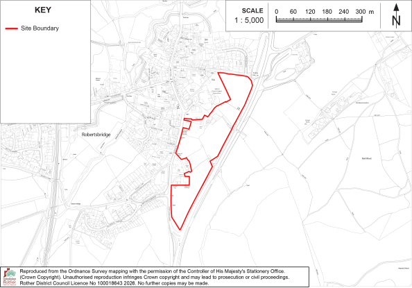
The site is allocated for residential development comprising 96 dwellings.
Development on this site must:
i. Provide a policy-compliant amount of on-site affordable housing in line with policy HOU2 of the Rother Local Plan;
ii. Provide for the retention and conversion of the Grade II listed barn within the site, to secure the conservation and long-term viable use of this heritage asset and its setting;
iii. Include areas of green infrastructure totalling some 2.74 hectares, including significant areas within the northern and southern end of the site, which will remain undeveloped;
iv. Allow for a comprehensive scheme to be developed across the whole site in the event the parcels of land come forward separately;
v. Retain and enhance the existing hedgerows and trees bounding the site, including those corresponding to historic field boundaries within the eastern half of the site area, and the “Locally important trees and hedgerows outside the Conservation Area” as designated through the Salehurst and Robertsbridge Neighbourhood Plan;
vi. Maintain key views towards surrounding wooded skylines through the layout and design of the development;
vii. Include vehicular access from George Hill to the west of the site, in accordance with requirements of the Highway Authority;
viii. Include appropriate active travel infrastructure inside and outside the site to link to the footways on the eastern side of George Hill and to Fair Lane, including a pedestrian connection to Public Right of Way ‘Salehurst and Robertsbridge 46’ within the north of the site;
ix. Be designed to ensure that new residents are not adversely impacted by noise or other forms of pollution from the A21 trunk road, in consultation with the Environmental Health department. Any physical structures forming part of any noise reduction scheme must respect the landscape character of the National Landscape;
x. Include any necessary off-site highway works necessary to make the development acceptable;
xi. Take account of Southern Water’s underground infrastructure in the design and layout of the site to ensure future access to existing sewerage infrastructure for maintenance and upsizing purposes. Easements would be required, which may affect the site layout or require diversion, and these should be clear of all proposed buildings and tree planting.
xii. Be informed by an odour assessment in respect of the nearby wastewater treatment works, in consultation with the wastewater operator for the works.
xiii. Preserve the setting of nearby listed buildings and the Robertsbridge Conservation Area;
xiv. Include an assessment and evaluation of the site’s archaeological potential and the implementation of any mitigation measures identified through the assessment;
xv. Incorporate the existing memorial bench on George Hill.
14.102This is a large site comprising a network of sloping fields, also containing buildings relating to the Grove Farm farmstead, including a Grade II listed barn and modern agricultural buildings, on the eastern edge of Robertsbridge. It is bordered by the A21 on its eastern boundary, bounding George Hill to the southwest and Fair Lane to the north. The western portion of the wider site (only) carries forward an allocation of 30 dwellings from the Salehurst and Robertsbridge Neighbourhood Plan. The site is in a sustainable location, in walking distance of services in the village and the mainline railway station, and this extended site provides an opportunity for additional residential development in this location.
14.103The site is within the Village Area Type, has a site size of 5.28 hectares and an indicative developable area of 2.74 hectares. It is allocated for some 96 dwellings at an indicative residential density of 35 dwellings per hectare.
14.104It is within the High Weald National Landscape and therefore a sensitive form of development is required in line with Local Plan policies. The site slopes up from the north to the south, with the southern section being higher topographically. The site includes a network of hedgerows, and the road-frontage of the site currently comprises a native hedgerow interspersed with a few trees, which will need to be retained as far as possible. Additionally, the site falls within the medium-risk impact (amber) zone for great crested newts and therefore an appropriate ecological survey will need to be undertaken.
14.105Towards the centre of the site there are buildings relating to the Grove Farm farmstead, including a Grade II listed barn and modern agricultural buildings. Furthermore, the northern portion of the site is adjacent to the Robertsbridge Conservation Area and is also within an Archaeological Notification Area. Development should create a sympathetic edge to Robertsbridge and be informed by a farmstead-inspired approach to layout and design, with opportunities to reference local materials within Robertsbridge Conservation Area. A previous planning permission included the residential conversion of the listed barn, and proposals will be required to secure the conservation and long-term viable use of this heritage asset and its setting.
14.106The northern and southern sections of the site are the most sensitive in landscape terms and should be retained and enhanced for public open space and biodiversity net gain, helping to reinforce the site's landscape setting, maintain important views towards surrounding wooded skylines and improve recreational connectivity. A connection should be made to public right of way “Salehurst and Robertsbridge 46”, which crosses the northern field. Treed areas and hedgerows along the site boundaries and within the site should be retained, with an adjacent buffer to development.
14.107Suitable vehicular access will need to be provided from George Hill. Previously, two separate vehicular accesses were approved for the area covering the Neighbourhood Plan allocation: on land between Yew Lodge and George Hill Cottage and utilising an existing farm track north of George Hill Cottage. The preferred vehicular access strategy is for this larger allocation is to use of these existing approved accesses. This would help reduce the landscape impact of a new access on George Hill and also reflects the Highway Authority's general preference to minimise the number of new access points. In any event, the site’s proximity to the A21 (part of the Strategic Road Network) means that a Transport Assessment to include assessment of the impact on the A21/George Hill junction, will be required in compliance with DfT Circular 01/2022. Furthermore, as the site abuts the A21, development proposals would need to consider any boundary issues in consultation with National Highways.
14.108Fair Lane is unsuitable to provide vehicular access to the site but should be used for pedestrian and cycle access, with a further pedestrian and cycle access to be provided to the southeast of the site, opposite Heathfield Gardens to encourage active travel. The footway on the eastern side of George Hill is relatively narrow and crossing facilities should be improved to encourage active travel trips to facilities within Robertsbridge and access to public transport. East Sussex County Council have also recommended that bus service contributions are likely to be required.
14.109The site undulates gradually downwards both from east to west and from south to north, and any development will need to incorporate sustainable drainage measures to ensure that any surface water is managed within the site and does not cause flooding downstream in the village, in accordance with Policy ENV2.
14.110A water main runs below the site which is likely to require an easement of 6 metres. Proposed layouts will need to take account of its location. Additionally, the site is within 500m of the wastewater treatment works on the eastern side of the A21. The site’s layout will need to be informed by an odour assessment to be undertaken in consultation with Southern Water.
14.111 Additionally, the site will need to be designed in a way that adequately protects future residents from noise and other forms of pollution arising from traffic on the A21 trunk road adjacent to the site. A scheme to this effect will need to be developed in coordination with the Environmental Health department, while ensuring that any physical measures such as noise attenuation fencing does not have an adverse impact on the National Landscape or the rural setting of the village.
14.112Overhead electricity cables run along part of the site’s frontage with the George Hill. Development proposals will require early engagement with the National Grid Electricity Transmission to ensure that they are safeguarded.
Policy RB3: Vicarage Land, Land south of the western end of Fair Lane, Robertsbridge Comment
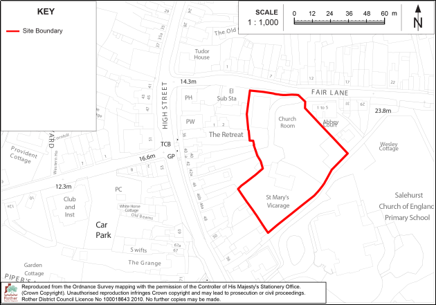
The site is allocated for residential development comprising 10 dwellings.
Development on this site must:
i. Provide a policy-compliant amount of on-site affordable housing in line with policy HOU2 of the Rother Local Plan;
ii. Be informed by a landscape assessment to determine an appropriate layout, form and detailed design to ensure the conservation and enhancement of the landscape and character of the High Weald National Landscape;
iii. Retain and enhance the existing hedgerow/ trees along the site frontage and the south east facing boundary;
iv. Include a new vehicular and pedestrian access off Fair Lane, to the approval of the Highway Authority;
v. Ensure design is sensitive in respect of the nearby listed buildings, and the site’s location within the Robertsbridge Conservation Area;
vi. Provide a new public right of way connection through the southern boundary to join up with Salehurst and Robertsbridge 45a;
vii. Be informed by an odour assessment in respect of the nearby wastewater treatment works, in consultation with the wastewater operator for the works;
viii. Include an assessment and evaluation of the site’s archaeological potential and the implementation of any mitigation measures identified through the assessment.
14.113This is a part brownfield, part greenfield site, containing a vicarage and ‘mission hall’, which would likely need to be demolished to accommodate a reasonable density of new dwellings. The allocation carries forward Policy HO2 of the Salehurst and Robertsbridge Neighbourhood Plan, which established the principle of accepting the loss of the mission hall.
14.114The site is within the Village Area Type, has a site size of 0.39 hectares and is allocated for some 10 dwellings at a density of 25 dwellings per hectare.
14.115It is within the High Weald National Landscape and therefore a sensitive form of development is required in line with Local Plan policies. The site is of a constrained nature, sloping south to north, while access on to Fair Lane is not straightforward, given its narrow width, concentration of listed buildings and the difference in level between the site and the road, and a sensitive design will be required. The site is also within the Robertsbridge Conservation Area and an Archaeological Notification Area.
14.116Development will additionally need to retain trees and hedgerow along the site’s frontage as well as the trees along the site’s southeastern boundary alongside footpath ‘Salehurst and Robertsbridge 45a’, which runs adjacent. A pedestrian connection to the footpath should be included in addition to pedestrian access onto Fair Lane to encourage active travel.
14.117The site is within 500m of the wastewater treatment works on the eastern side of the A21. The site’s layout will need to be informed by an odour assessment to be undertaken in consultation with Southern Water.
Policy RB4: Culverwells, Land north of Station Road, Robertsbridge Comment
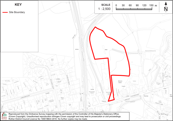
The site is allocated for residential-led development comprising:
- Some 21 new dwellings
- A doctors surgery containing 6 consulting rooms.
Development on this site must:
- Provide a policy-compliant amount of on-site affordable housing in line with policy HOU2 of the Rother Local Plan;
- Incorporate any recommendations from a site-specific flood risk assessment;
- Have no adverse effect on the integrity of the flood defence embankment; and maintain and where possible improve access to it, in order to allow for inspection, maintenance and future improvements;
- Ensure that the residential amenity of future occupiers is protected from any environmental impacts arising as a result of the site’s proximity to the railway;
- Retain and protect the existing ponds in the site and provide an appropriate buffer to any built development including roadways, as informed by an ecological survey to be completed;
- Retain and enhance as far as possible existing trees and hedgerows within the site area;
- Incorporate biodiversity improvements/ green blue infrastructure in the eastern part of the site;
- Include a vehicular access from Station Road;
- Include appropriate active travel infrastructure inside and outside the site to link to Station Road;
- Provide the doctor’s surgery at the southern end of the site;
- Be planned to ensure future access to existing sewerage infrastructure that crosses the site, for maintenance and upsizing purposes;
- Provide separate parking for the doctor’s surgery.
14.118 The site comprises some 2 hectares of undeveloped land on the northern edge of Robertsbridge, in close proximity to the railway station, an industrial estate, allotment gardens and residential properties.
14.119It is suitable for some 21 dwellings and a doctor’s surgery and benefits from planning permission for this use.
14.120It is within the High Weald National Landscape and therefore a sensitive form of development is required in line with Local Plan policies. The site comprises areas of semi-improved grasslands, isolated semi-mature trees and tree groups, species-poor hedgerow and overgrown planting, and a pond to the northern portion of the site. These will require specific care to be made regarding the retention and enhancement of biodiversity within the site. In addition, there is an area of deciduous woodland adjacent to the eastern boundary which is identified as a Priority Habitat. An area overlapping within the site’s eastern boundary, and then adjacent to the eastern boundary, is an Area that Could be of Importance to Biodiversity (ACIB), that is defined and mapped in the East Sussex and Brighton & Hove Local Nature Recovery Strategy (LNRS). Any proposed scheme will therefore be required to take opportunities as part of the Biodiversity Net Gain scheme to contribute to the measures and objectives of the LNRS.
14.121The northeast and eastern parts of the site are located in Flood Zone 3, with an adjacent strip of land in Flood Zone 2. New housing will need to be located on within higher areas of the site, outside Flood Zone 3. It will need to be demonstrated through a site-specific flood risk assessment that the development will be safe for its lifetime, taking account of the vulnerability of its users, without increasing flood risk elsewhere, and where possible, will reduce flood risk overall.
14.122A flood protection embankment to the River Rother/ Darwell Stream has been constructed adjacent to the eastern boundary of the site, which has been reflected in the policy requirements. Additionally, Southern Water infrastructure crosses the site and may require easements or diversion, while an overhead power line crosses the site east to west.
Policy RB5: Hodson's Mill, Northbridge Street, Robertsbridge Comment
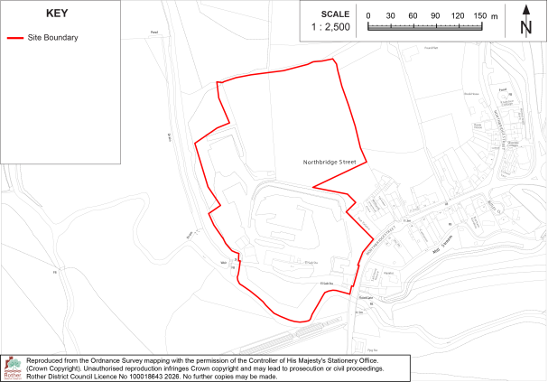
The site is allocated for residential and some commercial development, including the conversion of Hodson's Mill, comprising:
- Some 125 dwellings
- Flexible commercial, retail and/or community floorspace within the Former Mill Building
Development on this site must:
- Provide a policy-compliant amount of on-site affordable housing in line with policy HOU2 of the Rother Local Plan;
- Include flexible commercial, retail and/or community floorspace within the Former Mill Building;
- Secure the conservation and long-term viable use of the Former Mill Building and the Grade II listed Former Oast House to Mill Farm;
- Conserve and, where possible, enhance the setting of the Northbridge Street Conservation Area and the site's heritage assets;
- Protect, retain and incorporate the existing WWII pillbox within the development;
- Include an assessment and evaluation of the site’s archaeological potential and the implementation of any mitigation measures identified through the assessment;
- Incorporate any recommendations from a site-specific flood risk assessment;
- Have no adverse impacts on the integrity of flood defence assets relating to the River Rother, and maintain and where possible improve access, in order to allow for inspection, maintenance and future improvements;
- Ensure that there is no culverting of the River Rother and to avoid any deterioration to the water body during and after development;
- Provide vehicular, pedestrian and cycle access from Northbridge Street and demonstrate safe access during flood events, including any emergency access arrangements if required;
- Retain and enhance existing trees, woodland and hedgerows, including the historic north-south hedgerow, which should be maintained as a continuous landscape and ecological corridor;
- Protect and enhance the deciduous woodland priority habitat and associated ecological networks and deliver a strategic green infrastructure network that retains and incorporates Public Rights of Way Salehurst and Robertsbridge 8a, 8b and 28.
14.124This is a large, partly brownfield site on the northwestern edge of Northbridge Street comprising the derelict Hodson’s Mill and land to its immediate north including an adjacent open, undeveloped field. The overall site area is expected to deliver some 125 across 5.4 hectares, which includes ten homes within the Mill building itself and within the listed oast, along with the conversion of the ground floor to provide an area of flexible commercial, retail or community floorspace.
14.125The allocation carries forward Policy HO2 of the Salehurst and Robertsbridge Neighbourhood Plan which relates to the south-western half of the site only (“the Mill site”). However, the redevelopment of the Mill site is subject to a range of development costs, including those relating to heritage, flood risk and site preparation which means that development has not yet come forward. The inclusion of the adjacent field in the Local Plan allocation is intended to facilitate the comprehensive redevelopment of the site and assist in securing a viable development scheme.
14.126 All of the site area is within the High Weald National Landscape, and it contains priority habitat, while northern sections of the undeveloped field are topographically higher potentially visible from certain points within the wider landscape. Additionally, the historic field boundaries form the eastern, southern and most of the northern edges of this northern field, while being bisected by historic boundary hedgerow. Given its landscape sensitivity, development within this northern field should be limited to that which is demonstrated to be necessary to facilitate the appropriate redevelopment of the Mill Site in viability terms. There is also a public footpath running through the south, west and north of the wider site, which will need to be retained. An appropriate site design and layout will need to be informed by a Landscape and Visual Impact Assessment.
14.127There is an area of woodland within the northwest of the site, and adjacent to the north of the site, which is identified as a Priority Habitat. In addition, much of the south and west of the site included in an Area that Could be of Importance to Biodiversity (ACIB) that is defined and mapped in the East Sussex and Brighton & Hove Local Nature Recovery Strategy (LNRS). Any proposed scheme will therefore be required to take opportunities as part of the Biodiversity Net Gain scheme to contribute to the measures and objectives of the LNRS.
14.128The River Rother[13] runs through the south of the site, while also being adjacent to the site’s western boundary, with areas adjacent areas of the site being within Flood Zones 2 and 3 (medium to high risk of flooding). It will need to be demonstrated through a site-specific flood risk assessment that the development will be safe for its lifetime, taking account of the vulnerability of its users, without increasing flood risk elsewhere, and where possible, will reduce flood risk overall. Development proposals would need to demonstrate that safe access can be achieved in the event of flooding. There must be no increase in flood risk (depth or frequency) on or off site, and the scheme must provide flood storage compensation as required by the Environment Agency. As the River Rother is a ‘main river’, proposals will need to take account of the environmental permitting regulations and associated Environment Agency Assets. Depending on the final design, it is possible that flood mitigation measures may require the developer to improve performance or resilience of these assets. The Environment Agency also note that that the river is heavily modified in this location and that there may be opportunities to improve the watercourse here.
14.129 The site contains the Grade II listed Former Oast House to Mill Farm (the only surviving building of Mill Farm) and the locally listed Former Mill Building. It is also partially located within the Robertsbridge and Northbridge Street Conservation Area and an Archaeological Notification Area. An archaeological survey of the site will be required and should inform the layout and design of development. Development of the site should secure the conservation, enhancement and viable reuse of its heritage assets, whilst preserving or enhancing the character and appearance of the Conservation Area.
14.130East Sussex County Council have recommended that bus service contributions are likely to be required, while given the quantum of development proposed and the site’s proximity to the A21 (part of the Strategic Road Network) it is likely that a Transport Assessment to be approved by National Highways will be required where the proposed development could have a material impact on the roundabout where Northbridge Street joins the A21. Development proposals should also take opportunities to improve active travel connectivity between the site and Robertsbridge Railway Station where feasible and practicable. This may include the provision of a more direct walking and cycling connection to the station, subject to the availability of a deliverable route.
14.131Vehicular access, incorporating pedestrian and cycle access, will require an upgrade of the existing access onto Northbridge Street.
14.132Overhead electricity cables run along the site’s frontage with Northbridge Street. Development proposals will require early engagement with the National Grid Electricity Transmission to ensure that they are safeguarded.
Staplecross
Parish: Ewhurst
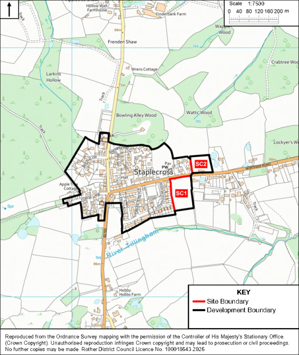
Policy SC1: Land east of Stockwood Meadow, Northiam Road, Staplecross Comment
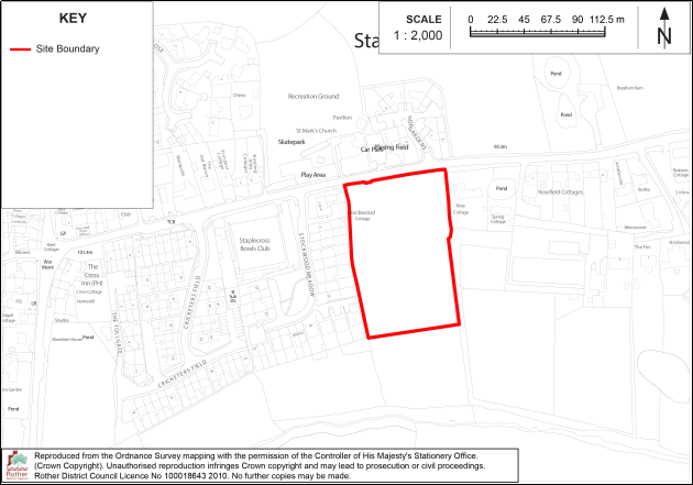
The site is allocated for residential development comprising 25 dwellings.
Development on this site must:
i. Provide a policy-compliant amount of on-site affordable housing in line with policy HOU2 of the Rother Local Plan;
ii. Include vehicular access from Northiam Road (the B2165)
iii. Improve pedestrian access to join up with existing footways in consultation with the highway authority, which may include crossing points and extension of 30mph speed limit along Northiam road (the B2165);
iv. Be designed to retain an open aspect across the site to the south to retain views across the countryside to the south, with dwellings constructed to share a central access road;
v. Include no built development in the northwestern part of the site which is shown to be at risk of surface water flooding;
vi. Retain and enhance the existing hedgerow and trees that bound the developable area of the site to the east, west and along the frontage on the northern boundary, which include historic field boundaries;
vii. Be designed to ensure future access to existing sewerage infrastructure for maintenance and upsizing purposes;
viii. Include an assessment and evaluation of the site’s archaeological potential and the implementation of any mitigation measures identified through the assessment.
14.133This is an open field in the eastern part of Staplecross village, adjacent to a recently constructed housing development at Stockwood Meadow, south of Northiam Road (the B2165). It is well located within walking distance of village services including the primary school. Connections to the nearby footway infrastructure to encourage active travel are required, as detailed above.
14.134The site is within the Village Area Type, has a site size of 1.07 hectares and an indicative developable area of 0.7 hectares. It is allocated for some 25 dwellings at an indicative residential density of 35 dwellings per hectare.
14.135Given the presence of some development on either side of the site and on the opposite side of Northiam Road, there is scope for additional residential development at this location, in line with the southern extent of the Stockwood Meadow development.
14.136The site is within the High Weald National Landscape and therefore a sensitive form of development is required in line with Local Plan policies. The site is bound by historic field boundaries to the north, west and the northern section of the eastern boundary. Its development will be subject to the retention and enhancement of existing hedgerows and trees along the site’s boundaries, and most notably the roadside hedgerow, which is an important feature in the streetscape in this part of the village. Furthermore, the site will need to be carefully designed to retain views across the countryside to the south. Development should also avoid the northwest portion of the site which is at risk of surface water flooding.
14.137Southern Water’s sewerage infrastructure crosses the site in several places and may require easements or diversion, which will need to be factored into the layout of any proposed development. Consultation with Southern Water will therefore be required.
14.138An archaeological Notification Area covering the historic core of the village is located some 40m to the west of the site.
Policy SC2: Land east of Hop Gardens, Northiam Road, Staplecross Comment
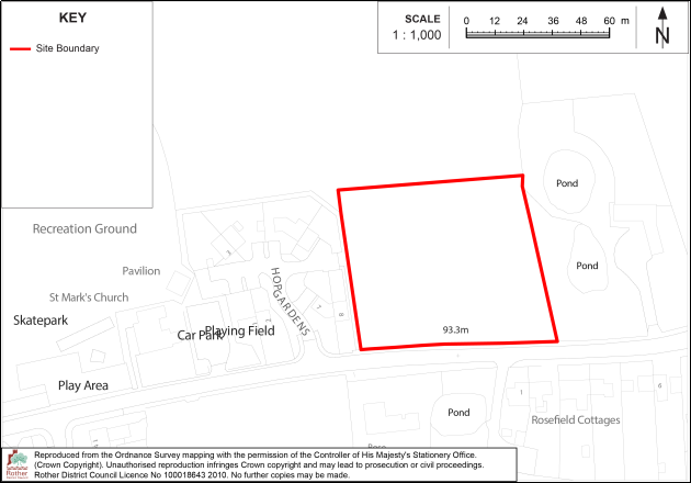
The site is allocated for residential development comprising 10 dwellings.
Development on this site must:
i. Provide a policy-compliant amount of on-site affordable housing in line with policy HOU2 of the Rother Local Plan;
ii. Be laid out to retain views north-south across the site;
iii. Include a new vehicular access from Northiam Road (B2165);
iv. Include an area of green infrastructure in the south-western corner of the site to allow the retention of the mature oak tree within this part of the site;
v. Retain and enhance the existing trees and hedgerows on the southern and eastern boundaries of the site which are historic field boundaries, except for the section that will have to be removed to form a singular vehicular and pedestrian access onto Northiam Road. The access point shall avoid the western corner of the site to protect the mature Oak tree;
vi. Be designed to ensure that the setting of the Grade II listed “Brayburn Farm Barn” to the east is protected;
vii. Include an assessment and evaluation of the site’s archaeological potential and the implementation of any mitigation measures identified through the assessment;
viii. Include any necessary off-site highway works necessary to make the development acceptable.
14.139The site forms part of an open field on the northern side of Northiam Road, in the eastern part of the village of Staplecross. It is set between Hop Gardens, a small housing development to the west, and the curtilage of a Grade II listed barn to the east.
14.140The site is within the Village Area Type, has a site size of 0.55 hectares and an indicative developable area of 0.35 hectares. It is allocated for some 10 dwellings at an indicative residential density of 30 dwellings per hectare.
14.141 It provides an opportunity for a small number of dwellings in a sustainable location within walking distance of services within the village, including the primary school.
14.142 The site is within the High Weald National Landscape, and the wider field allows for far reaching views across the wider landscape to the north. Consequently, a sensitive form of development is required in line with Local Plan policies, while the site design and layout will need to allow a substantial portion of the views to be retained across the site from the roadside, and a slightly lower indicative site density of 30 dwellings per hectare is therefore required. The southern frontage and eastern boundaries are formed by historic field boundaries. Policy requirements detailed above will ensure the retention of boundary hedgerows.
14.143 A portion of the hedgerow will need to be removed in order to provide vehicular access, while connections to the existing footway infrastructure fronting the site will be required, and to encourage active travel.
14.144 An archaeological Notification Area covering the historic core of the village is located some 135m to the west of the site. Proposals will need to ensure that the rural setting of the listed barn to the east of the site is not adversely impacted.
14.145 Overhead electricity cables run through the site and along part of the site’s frontage with Hawkhurst Road. Development proposals will require early engagement with the National Grid Electricity Transmission to ensure that they are safeguarded.
Flimwell
Parish: Ticehurst
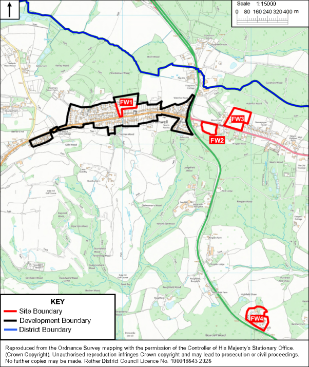
Policy FW1: Land rear of Fruitfields, High Street, Flimwell Comment
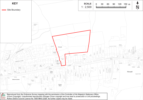
The site is allocated for residential development comprising 27 dwellings.
Development on this site must:
i. Provide a policy-compliant amount of on-site affordable housing in line with policy HOU2 of the Rother Local Plan;
ii. Focus built development to the southern half of the site, with the northern half to comprise green infrastructure and necessary buffers to woodland, as detailed in criterion (iii);
iii. Include an area of green infrastructure, to include the retention and enhancement of treed areas and hedgerows within the site, including deciduous woodland priority habitat, the trees forming the east and west site boundaries, and any other significant trees or groups of trees within the site. This will be inclusive of the provision for the retention and future management of a buffer zone of semi-natural habitat, of at least, or potentially more than, 15 metres wide, within the north of the site, between the edge of development and the ancient woodland;
iv. Be designed to protect the residential amenity of the occupiers of existing dwellings adjacent to the site;
v. Provide new vehicular and active travel access onto Union Street while retaining Public Right of Way ‘Ticehurst 11b’ separate from the site’s vehicular access;
vi. Include any necessary off-site highway works necessary to make the development acceptable.
14.147This site takes forward an allocation in the Ticehurst Neighbourhood Development Plan and includes additional land to the east, to the rear of properties fronting Union Street. The original allocation is extended in order to improve viability and enable the site to come forward. The extended site provides an opportunity to provide additional dwellings in the village without harming the landscape or character of the High Weald National Landscape, subject to the policy requirements.
14.148The site is within the Village Area Type, has a site size of 1.91 hectares and an indicative developable area of 0.9 hectares. It is allocated for some 27 dwellings at an indicative residential density of 30 dwellings per hectare. While the site is well contained in the wider landscape by existing development and woodland, there are a number of constraints on site which ultimately reduce the developable area.
14.149It is within the High Weald National Landscape and therefore a sensitive form of development is required in line with Local Plan policies. The northern areas of the site have considerable tree cover, including Wardsdown Wood. There is an area of woodland within the northern boundary and adjacent to the eastern boundary which is identified as a Priority Habitat and defined as Area that Could be of Importance to Biodiversity (ACIB) in the East Sussex and Brighton & Hove Local Nature Recovery Strategy (LNRS). There is also an area of Ancient Woodland adjacent to the whole northern boundary that is defined as an Area that is of Particular Importance to Biodiversity (APIB) in the LNRS. Any proposed scheme will therefore be required to take opportunities as part of the Biodiversity Net Gain scheme to contribute to the measures and objectives of the LNRS. There are further areas of tree cover within the site and along the boundaries that will also need to be retained, to ensure the protection of landscape character and biodiversity. The more substantially treed sections of the site are included within the area that is suitable for Green Infrastructure. Consequently, development should be focused within southern areas of the site.
14.150Given the presence of ancient woodland and deciduous woodland priority habitat, it is important that the developable sections of the site are designed in line with the High Weald National Landscape Unit’s Technical Advice Note on Dark Skies in the High Weald.
14.151There are areas within the east and notably the northeast of the site that are vulnerable to surface water flooding, which gathers northward of the site in a downhill direction as a tributary of the ecologically sensitive River Bewl, 165 metres to the north. It is understood that the adjacent dwellings at Fruitfields have a channel underneath to allow water run-off from Union Street to flow down to the fields. Existing surface water management arrangements will need to be taken into account in designing an appropriate Sustainable Drainage scheme to serve the site, to ensure the proposal does not increase the risk of flooding on adjacent land.
14.152Vehicular access to the site would be provided from Union Street to the south. Development would need to safeguard the continued use of the existing access route extending north of the site and retain any associated third-party vehicular access rights. The existing Public Right of Way (Ticehurst 11b), which runs from Union Street to Wardsdown Woods, would also need to be retained and remain separate from the site's vehicular access.
14.153Connections to the nearby footway infrastructure to encourage active travel are required, while East Sussex County Council have advised that bus service contributions will be required.
Policy FW2: Land south of Hawkhurst Road, Flimwell Comment
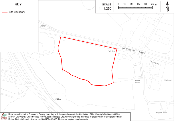
The site is allocated for employment development comprising some 1,800 sqm of employment floorspace (use class E(g), B2 or B8).
Development on this site must:
i. Contain an area of Green Infrastructure, to include a suitable buffer zone of semi-natural habitat on the southern boundary, between the edge of development and the deciduous woodland which would include biodiversity net gain;
ii. Retain the existing trees bounding the site, including a buffer to development, especially along the western and northern boundaries;
iii. Provide a new vehicular access onto Hawkhurst Road in agreement with the Highway Authority, also taking into account any comments of Kent County Council;
iv. Include appropriate active travel infrastructure inside and outside the site to link to footways on the northern side of Hawkhurst Road;
v. Include any necessary off-site highway works necessary to make the development acceptable.
14.155The site forms a small field on the southern side of Hawkhurst Road, which is bound on all sides by trees, including deciduous woodland to the south and a mature tree belt along the frontage with Hawkhurst Road. The site sits adjacent to a furniture showroom to the west and a covered reservoir to the east.
14.156The site is 0.87 hectares in size, with an indicative developable area of 0.45 hectares, with the remaining area allocated for green infrastructure, and is allocated for some 1,800sqm of employment floorspace. The allocation provides flexibility in terms of the specific employment use class delivered. The most appropriate use class, or mix of uses, will be determined at planning application stage, having regard to market demand and site-specific considerations.
14.157 It is within the High Weald National Landscape and therefore a sensitive form of development is required in line with Local Plan policies. There is an area of woodland adjacent to the southern boundary which is identified as a Priority Habitat. This and much of the area within the site is also defined as an Area that Could be of Importance to Biodiversity (ACIB) as defined and mapped in the East Sussex and Brighton & Hove Local Nature Recovery Strategy (LNRS). Any proposed scheme will therefore be required to take opportunities as part of the Biodiversity Net Gain scheme to contribute to the measures and objectives of the LNRS.
14.158Given the bounding vegetation and woodland, the site is well enclosed within the landscape and could accommodate a sensitive commercial development. This is subject to the retention of mature boundary trees and the protection of the adjoining woodland, including buffers and an additional area of green infrastructure along the southern boundary with the woodland.
14.159 Achieving safe vehicular access and the potential impacts on the capacity of the nearby A21 crossroads will require detailed highways assessments. In addition, footway improvements on the southern side of Hawkhurst Road between the site and the A21, in combination with enhancements provided on the north of Hawkhurst Road as required by Policy FW3, will need to enable safe and convenient pedestrian access, and to encourage active travel. A full safety risk assessment covering impacts on the Strategic Road Network (the A21) will require a Transport Assessment at the planning application stage, while early engagement with National Highways is also encouraged at pre-application stage. The Transport Assessment will need to include an assessment of the site’s impact on the A21/Hawkhurst Road junction in compliance with DfT Circular 01/2022 and the DRMB. In addition, East Sussex County Council have advised that bus stop upgrades in the form of Real Time Passenger Information and service contributions are likely to be required.
Policy FW3: Land north of Hawkhurst Road, Flimwell Comment
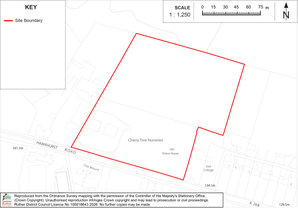
The site is allocated for residential development comprising 35 dwellings.
Development on this site must:
i. Provide a policy-compliant amount of on-site affordable housing in line with policy HOU2 of the Rother Local Plan within the site to the north of Hawkhurst Road.
ii. Include an area of green infrastructure and on-site Biodiversity Net Gain, which includes provision for the retention and future management of a buffer zone of semi-natural habitat, at least 15 metres wide, on the northern boundary, between the edge of development and the ancient woodland;
iii. Retain and enhance existing hedgerows and trees bounding and within the site area, having particular regard to the site frontage;
iv. Create a new tree belt along the eastern boundary of the northern field;
v. Provide new vehicular access onto Hawkhurst Road in agreement with the Highway Authority, also taking into account any comments of Kent County Council;
vi. Include appropriate active travel infrastructure inside and outside the site to link to footways on the northern side of Hawkhurst Road;
vii. Include any necessary off-site highway works necessary to make the development acceptable.
14.160The site comprises two rectangular fields on the northern side of Hawkhurst Road. The southern field, adjacent to the roadside, is currently in use as a plant nursery and contains associated structures. A retail use lies to the west, with dwellings to the east.
14.161The site is within the Village Area Type, has a site size of 2.19 hectares and an indicative developable area of 1.1 hectares. It is allocated for some 35 dwellings at an indicative residential density of 32 dwellings per hectare.
14.162The site gradually slopes down in an easterly direction, but also to the north where the site is bound by an extensive area of Woodland. Given the extent of this woodland, the site is relatively well contained within the landscape and could accommodate a residential development without significant impacts on landscape character and views.
14.163It is within the High Weald National Landscape and therefore a sensitive form of development is required in line with Local Plan policies. The two fields forming the site comprise sections of a wider medieval fieldscape, although now impacted upon by existing development along Hawkhurst Road. Of additional potential significance to the National Landscape is the location of the former Mount Farm to the northwest of the site, which is identified as an Historic Farmstead within the High Weald National Landscape dataset, however this is reported to be significantly lost.
14.164The policy requirements require the retention of roadside boundary hedgerows (where present) and an appropriate buffer to the ancient woodland to the north. Existing trees and hedges forming field boundaries within and at the edges of the site will also need to be retained, including buffers to development, while a new tree belt along the east and south facing eastern boundary will create a buffer to the landscape and existing residential gardens to the east.
14.165 There is an area of Ancient Woodland adjacent to the whole northern boundary which is identified as an Area that is of Particular Importance to Biodiversity (APIB) as defined and mapped in the East Sussex and Brighton & Hove Local Nature Recovery Strategy (LNRS). There is also an area covering the southern half of the site that is identified as an Area that Could be of Importance to Biodiversity (ACIB) in LNRS. Any proposed scheme will therefore be required to take opportunities as part of the Biodiversity Net Gain scheme to contribute to the measures and objectives of the LNRS.
14.166While the proposal would result in the loss of the plant nursery that occupies the southern part of the site, the land is understood to be available for redevelopment within the Plan period. Additional dwellings here would not be out of character with the locality. The nursery is relatively recently established, and having regard to the need for housing, its redevelopment can be accepted.
14.167 Achieving safe vehicular access and mitigating potential impacts on the capacity and operation of the nearby A21/Hawkhurst Road crossroads will require detailed highways assessment. In addition, footway improvements on the northern side of Hawkhurst Road between the site and the A21 will be required to provide safe and convenient pedestrian access and support active travel. Whilst vehicular access would be taken from Hawkhurst Road, the site's proximity to the A21, which forms part of the Strategic Road Network, means that a Transport Assessment will be required, and early engagement with National Highways is encouraged at pre-application stage. The Transport Assessment should assess the impact of the development on the operation and safety of the A21/Hawkhurst Road junction in accordance with DfT Circular 01/2022 and the Design Manual for Roads and Bridges (DMRB). Supporting work is expected to include a Stage 1 Road Safety Audit and a Walking, Cycling and Horse-Riding Assessment. East Sussex County Council has also advised that bus stop upgrades, including Real Time Passenger Information, together with contributions towards local bus services, are likely to be sought.
14.168Southern Water’s initial checks indicate that the site may have limited local network capacity, and therefore the phasing of development may be needed alongside network.
Policy FW4: Land at Cedar Farm, London Road Comment
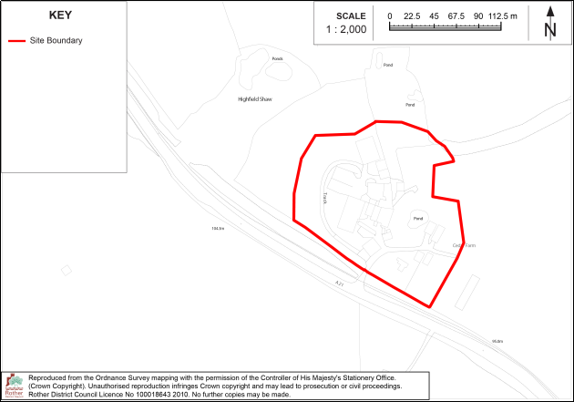
The site is allocated for employment development comprising some 2,400 sqm of employment floorspace (use class E(g), B2 or B8).
New employment development on this site must:
i. Be restricted to the area currently occupied by farm buildings and areas of hardstanding within the west of the site;
ii. Be designed to be in keeping with the agricultural character of the site, including through the style of new buildings;
iii. Include provision for the retention and future management of a buffer zone of semi-natural habitat, at least 15 metres to the Ancient Woodland in the north of the site;
iv. Retain and enhance the pond and surrounding trees within the site and provide an appropriate buffer to any built development including roadways, as informed by ecological surveys, to be completed to support the planning application;
v. Utilise the existing farm access onto the A21, subject to the approval of National Highways;
vi. Include appropriate pedestrian infrastructure to link to the existing footway along the eastern side of the A21;
vii. Include any necessary off-site highway works necessary to make the development acceptable.
14.169The site comprises a collection of agricultural buildings and hardstanding, associated with an established agricultural enterprise, on the eastern side of the A21 London Road, in the south of Flimwell. Some of the buildings are expected to fall out of agricultural use over the coming years, which will provide an opportunity for their redevelopment for employment use.
14.170While the total site area is 2.26 hectares, the developable area is 0.6 hectares for up to 2,400 sqm, which reflects its rural location and the presence of landscape features and other uses within the site area. The allocation provides flexibility in terms of the specific employment use class delivered. The most appropriate use class, or mix of uses, will be determined at planning application stage, having regard to market demand and site-specific considerations.
14.171The site is not within walking distance of a settlement, however it benefits from an existing access from a trunk road, while this section of the A21 includes footways alongside the A21 that connect to Flimwell, some 1.8km to the north, and Hurst Green, some 2km the south. Providing a connection from the site onto this footway therefore provides opportunities for active travel. Moreover, national planning policy supports the sustainable growth and expansion of all types of business in rural areas, recognising that sites in rural areas may have to be found beyond existing settlements.
14.172The site is within the High Weald National Landscape and therefore a sensitive form of development is required in line with Local Plan policies. The site is generally well contained within the landscape due to the presence of woodland that envelops the site from the west to the north, with the addition of a dense tree belt that forms the northeast boundary of the A21 in this location. To the east of the site area is a cluster of trees centred around a pond at the centre of the farmstead, as well as a residential building and polytunnels, all of which further contribute to the site’s screening from the wider landscape.
14.173 There is an area of Ancient Woodland within the northern part of the site which is identified as an Area that is of Particular Importance to Biodiversity (APIB) as defined and mapped in the East Sussex and Brighton & Hove Local Nature Recovery Strategy (LNRS). There is also an area covering the southeastern half of the site that is identified as an Area that Could be of Importance to Biodiversity (ACIB). Any proposed scheme will therefore be required to take opportunities as part of the Biodiversity Net Gain scheme to contribute to the measures and objectives of the LNRS. The policy requirements detailed above require their retention of the identified landscape features.
14.174Given the countryside location, it is also important that any new employment buildings reflect the form of the existing farmstead. This includes consideration of building heights, scale and design, as well as any natural boundary treatments that would reduce the visibility of new development within the landscape.
14.175Vehicular access onto the A21 trunk road will be required. Any proposed upgrade/improvement of the existing access will need to be fully assessed in line with the relevant guidance set out in DfT Circular 01/2022, the Design Manual for Roads and Bridges (DMRB). As the site abuts the A21, consultation with National Highways will also be necessary for any boundary issues.
Ticehurst
Parish: Ticehurst
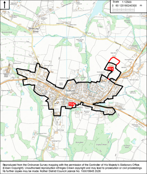
Policy TC1: Land at Steellands Farm, Field Rise, Ticehurst Comment
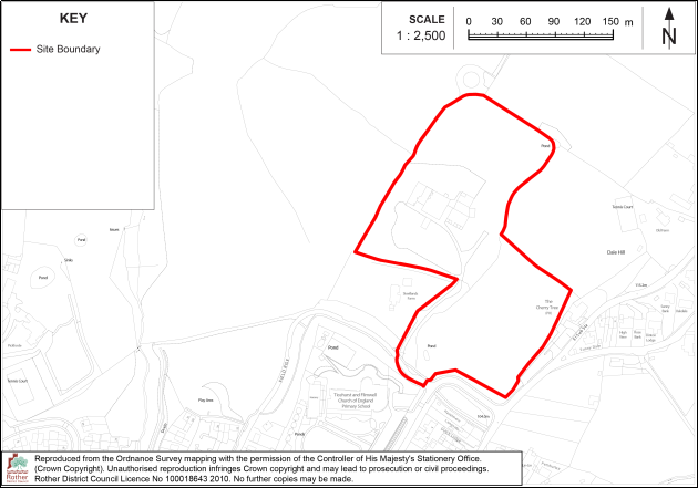
The site is allocated for residential development comprising 42 dwellings, including some 15 within the southern field and 27 in the northern field.
Development on this site must:
i. Provide a policy-compliant amount of on-site affordable housing in line with policy HOU2 of the Rother Local Plan;
ii. Focus development to the southern halves of both the southern and northern fields;
iii. Retain and reinforce existing hedgerows, tree belts and scrub vegetation around the site perimeter, which form historic field boundaries, including reinforcement of currently weak boundary sections;
iv. Include an area of green infrastructure, to include biodiversity net gain, across the northeastern corner of the southern field, including the planting of a new tree belt along the eastern boundary;
v. Include an area of green infrastructure within the northern half of the northern field to include a new tree boundary along the site’s northeast edge;
vi. Retain and protect the existing ponds within the site’s southern boundary and provide an appropriate buffer to any built development including roadways, as informed by an ecological survey to be completed;
vii. Include vehicular and pedestrian access from Field Rise using the route of the existing farm track;
viii. Include appropriate active travel infrastructure within the site, including a new pedestrian and cycle path leading from Field Rise northwards through the site, and providing for a link beyond the northeastern boundary towards Tinkers Lane (subject to land availability);
ix. Be designed to ensure future access to any existing sewerage infrastructure for maintenance and upsizing purposes.
14.176The site is formed of two adjacent fields that share a central access track, leading north from Field Rise, a modern housing development opposite Ticehurst and Flimwell Primary School. It would represent a logical extension to the village in a sustainable location.
14.177The site is within the Village Area Type. It has a site size of 3.88 hectares and a developable area of 1.5 hectares and is allocated for some 42 dwellings at an indicative residential density of 30 dwellings per hectare. Across the two fields that make up the site, the developable area comprises some 0.5 hectares in the southern field and 1 hectare in the northern field.
14.178The site is within the High Weald National Landscape and therefore a sensitive form of development is required in line with Local Plan policies. Both fields are almost entirely enclosed by historic field boundaries, dividing the site into two distinct areas. This dividing boundary, together with the trees and hedgerows on the outer site boundaries, will need to be retained and enhanced as character features of the HWNL, while they also serve to help screen each side of the site from longer views. Development proposals will also need to include appropriate landscape buffers between built development and existing trees, hedgerows, ponds and other retained landscape features. Across both fields, development should respond to the historic settlement pattern of Dale Hill and be informed by a farmstead-inspired approach to layout, scale and design.
14.179 The southern portion of the site forms an open field which slopes up from south to north, although it is relatively well contained other than on its southern boundary. However, the site itself is topographically prominent to the immediate landscape and village to the south. Additionally, this part of the site lies adjacent to a grade II listed public house to the east. Consequently, development opportunities here are more limited, and this part of the site could be more suited to some single-storey dwellings, together with areas of Green Infrastructure including new tree planting along the eastern boundary. The prominent northern end of the site should remain undeveloped. A landscape buffer should also be provided adjacent to the Cherry Tree Public House to preserve its setting which would form an area of Green Infrastructure and habitat creation. The existing ponds and adjoining vegetation at the western end of the field should be retained, enhanced and incorporated within the overall Green Infrastructure network.
14.180The northern portion of the site is enclosed by trees to the east, south and west. Development should be limited to its southern section, focused around the footprint of the existing farm buildings, with the northern part retained as Green Infrastructure with further boundary planting to strengthen landscape containment and screen views from the north. This part of the site contains a number of modern farm buildings, which will need to be removed.
14.181Vehicular, pedestrian and cycle access should be made via the formalisation of the existing track to Steellands Farm. Initial comments of the Highway Authority suggest that a vehicular access is likely to be achievable but the impact of development traffic on the nearby school drop and pick up periods, alongside other development traffic, would need to be assessed.
14.182 Given the scale and location of the development, it is also appropriate to require off-site improvements to pedestrian and cycle infrastructure, as currently there is no footway on a long stretch of the B2087 between Flimwell (to the northeast) and Ticehurst Primary School (to the south). While a new footway spanning the journey from Flimwell is unfeasible, measures to improve active travel connections could include a new pedestrian connection leading from and beyond the northeastern boundary of the site towards Tinkers Lane, subject to land being available. East Sussex County Council have advised that bus stop upgrades in the form of Real Time Passenger Information and service contributions are likely to be required.
14.183 Southern Water’s initial checks indicate that there may be limited local network capacity, and therefore the phasing of development may be needed alongside network reinforcement prior to occupation of the total number of dwellings indicated in each policy. Southern Water have also advised that sewerage infrastructure crosses the site, and therefore easements or diversion may be required within the layout of development proposals.
14.184The site is also crossed by overhead electricity cables, running northwest to southeast, which are located along the treed northeastern boundary of the southern field and through the centre of the northern field. Development proposals will require early engagement with the National Grid Electricity Transmission to ensure that they are safeguarded.
Policy TC2: Orchard Farm, Ticehurst Village Comment
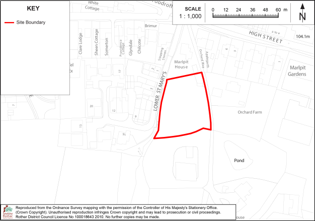
The site is allocated for residential development comprising at least 5 dwellings.
Development on this site must:
i. Retain and protect boundary trees and hedgerows, including the mature tree lines along the site boundaries, and provide replacement planting where loss is unavoidable;
ii. Maintain an appropriate landscaped buffer to adjoining deciduous woodland on the southern boundary;
iii. Provide vehicular and pedestrian access from Lower St Mary's and/or the existing private drive serving Orchard House;
iv. Incorporate the recommendations of the Level 2 Strategic Flood Risk Assessment;
v. Incorporate measures to protect existing watercourses and ensure that development does not increase the risk of flooding nearby;
vi. Include no built development in areas that are shown to be at risk of significant surface water flooding within west and north of the site.
14.185This is a small site of former nursery land to the south of the High Street in Ticehurst, surrounded by existing development on all sides except to the south. The policy takes forward an allocation (Policy H2) of the Ticehurst Neighbourhood Development Plan.
14.186The site is within the Village Area Type, has a site size of 0.23 hectares and is allocated for at least 5 dwellings.
14.187It is within the High Weald National Landscape and therefore a sensitive form of development is required in line with Local Plan policies. The site contains a number of mature trees, hedgerows and other ecological features. There is also an area of woodland adjacent to the southern boundary and adjacent to the eastern boundary which is identified as a Priority Habitat and Area that Could be of Importance to Biodiversity (ACIB) as defined and mapped in the East Sussex and Brighton & Hove Local Nature Recovery Strategy (LNRS). Any proposed scheme will therefore be required to take opportunities as part of the Biodiversity Net Gain scheme to contribute to the measures and objectives of the LNRS. The policy requirements require the protection of boundary trees, tree groups and hedgerows, including the established tree lines along the site boundaries, while replacement planting should be undertaken where losses are unavoidable. A suitable buffer to the adjoining deciduous woodland will be required.
14.188 Watercourses and drainage ditches are present along the southern and western boundaries of the site. Site screening has identified that parts of the site are at risk from surface water flooding, and therefore, development will need to incorporate recommendations from the Level 2 Strategic Flood Risk Assessment, as follows:
- Carry out a site-specific flood risk assessment to demonstrate the development will be safe for its lifetime;
- Take a sequential approach by locating the most vulnerable aspects of development in those areas of the site with lowest flood risks;
- Utilise SuDS with multiple benefits throughout the site, particularly in areas of predicted surface water ponding;
- Maintain a buffer distance (minimum 8 metres) from the Ordinary Watercourse adjacent to the site to allow access and maintenance;
- A Flood Response Plan may be required if the main access to the site remains at risk of flooding during the design flood event.
14.189Access arrangements previously approved for the site utilise both Lower St Mary's and the existing private drive serving Orchard House, with future proposals expected to take account of these established access arrangements.
Stonegate
Parish: Ticehurst
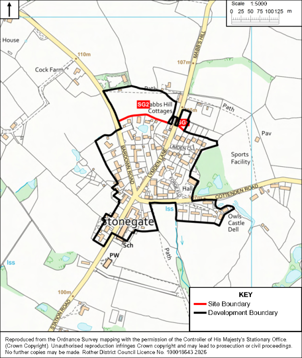
Policy SG1: Land at Lymden Lane, Stonegate Comment
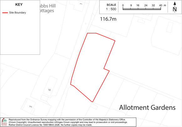
The site is allocated for residential development comprising 5 dwellings.
Development on this site must:
i. Include dwellings in a terraced formation;
ii. Retain and enhance as much of the hedgerow fronting the site as possible (excepting a section to be removed to facilitate access);
iii. Include vehicular and pedestrian access from Lymden Lane;
iv. Include an area for onsite vehicle turning;
v. Include any necessary on-site or off-site highway works necessary to make the development acceptable;
vi. Be informed by an odour assessment in respect of the nearby Stonegate wastewater treatment works, in consultation with the wastewater operator for the works.
14.190The site forms a small section of a larger field on the eastern side of Lymden Lane, on the northern edge of Stonegate. It is relatively well contained and relates well to adjoining residential development. It provides an opportunity for a small number of dwellings in a village with some key services including a primary school and nearby railway station.
14.191The site is limited in size, however, reflecting the terraced housing of nearby Mabbs Hill Cottages across the road, it is considered that it could accommodate five small (two to three bedroom) terraced dwellings.
14.192 It is within the High Weald National Landscape and therefore a sensitive form of development is required in line with Local Plan policies. While the existing hedgerow frontage would need to be removed in part to accommodate access, there is an opportunity to enhance the remaining hedgerow sections with additional native planting.
14.193Lymden Lane is a narrow, winding lane, the site being located in a section subject to a 30mph speed limit. Development will need to be supported by appropriate transport evidence to demonstrate safe pedestrian access to services further south in the village.
14.194The site is within 500m of the wastewater treatment works on the eastern side of the A21. The site’s layout will need to be informed by an odour assessment to be undertaken in consultation with Southern Water.
Policy SG2: Land east of Bardown Road, Stonegate Comment
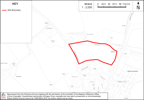
The site is allocated for residential development comprising 20 dwellings.
Development on this site must:
i. Provide a policy-compliant amount of on-site affordable housing in line with policy HOU2 of the Rother Local Plan;
ii. Retain and enhance the public right of way Footpath ‘Ticehurst 34’;
iii. Retain and enhance the existing hedgerows and tree belts that enclose the site on all sides, except for any short sections that need to be removed to facilitate access, which should be minimised as far as possible, and include additional tree planting along the western and northern boundaries;
iv. Include a new vehicular access from Bardown Road to the approval of the Highways Authority;
v. Be informed by transport evidence to demonstrate a safe pedestrian access from the site to join up with the village centre to the south, and incorporate any off-site highway improvements necessary to provide a safe pedestrian route;
vi. Ensure there is no adverse effect on groundwater in respect of the Source Protection Zone within the northwest of the site;
vii. Be designed to ensure future access to existing sewerage infrastructure lying adjacent to the south of the site, for maintenance and upsizing purposes;
viii. Be informed by an odour assessment in respect of the nearby wastewater treatment works, in consultation with the wastewater operator for the works;
ix. Include an assessment and evaluation of the site’s archaeological potential and the implementation of any mitigation measures identified through the assessment.
14.195This is a field on the northern edge of Stonegate within the High Weald National Landscape. It is adjacent to residential development to the south, while open countryside extends to the north and the west. The site is located between Bardown Road to the west and a strip of residential curtilages that front Lymden Lane to the east. The field slopes slightly up to the north and northeast, while the landscape falls away to the north and west.
14.196The site is within the Village Area Type, has a site size of 1.25 hectares and an indicative developable area of 0.63 hectares. It is allocated for some 20 dwellings at an indicative residential density of 35 dwellings per hectare.
14.197Public footpath ‘Ticehurst 34’ runs east to west through the northern part of the site. It is not easily accessed at present from either entry point. Any development would need to retain and enhance this footpath within an area of on-site Green Infrastructure, while also improving and maintaining both entry points.
14.198The site is within the High Weald National Landscape and therefore a sensitive form of development is required in line with Local Plan policies. It is bound on all sides by hedgerows and tree belts, which are effective in screening much of the site from the surrounding area, however the site’s topographical prominence means rooftops would be visible from the west, while the land level falls away to the north. In addition, the formation of a vehicular access point on Bardown Road would require the removal of a length of the existing hedgerow along the western boundary which would open up views of the site to an extent. For these reasons, additional tree planting will be required to bolster site screening along the remainder of the western boundary and parts of the northern boundary. The site layout and the position of the access will need to be informed by a Landscape and Visual Impact Assessment and it is likely that the southern and eastern sections will be most suited to built development due to their closer relationship with the existing built form of the village, however, a careful design will be necessary to protect the amenity of the adjacent dwellings to the south. The design should also allow for a substantial area of Green Infrastructure relative to the site’s developable area to respect the edge of village location and provide an appropriate transition to the countryside.
14.199 A small area adjacent to the north of the site, within the curtilage of Broom Bungalow, has been mapped and defined in the East Sussex Local Nature Recovery Strategy as an Area that Could become of Importance for Biodiversity (APIB) given the presence of sandstone outcrop. Any proposed scheme will therefore be required to take opportunities as part of the Biodiversity Net Gain scheme to contribute to the measures and objectives of the LNRS.
14.200There is a large archaeological notification area associated with Bardown Farm, less than 300m to the north.
14.201In respect of pedestrian access, in this location, Bardown Road is subject to the national speed limit and while this changes to a 30mph limit further south, the road becomes narrow and lacks footway provision, or the possibility for a footway provision, for much of the route into the village. Consequently, the suitability of access to the site, particularly in relation to pedestrian accessibility, requires further assessment and consideration by the Highway Authority, including a Stage 1 Road Safety Audit (RSA1). Bardown Road is not considered suitable to provide the sole means of pedestrian access to the village. Alternative options could include an additional pedestrian connection to Lymden Lane to the east (which, while not ideal, is more suited to use by active travel users compared to Bardown Road); however, the presence of intervening third-party land is likely to affect the deliverability of this approach. The existing Public Right of Way connection from the site onto Lymden Lane does provide an existing pedestrian route, however the nature of the path close to Lymden Lane does not provide good accessibility for all users as it includes steps. Improvements will be needed as part of any application.
14.202The north-western corner of the site is within a Source Protection Zone (SPZ3), which covers a wide area around a water abstraction point, and development will need to ensure there is no adverse effect on groundwater. Sustainable drainage features will also be required to ensure that there are no adverse impacts on the pond within the adjoining residential development at The Acorns, which sits topographically lower than this site. In addition, a wastewater pipe is located adjacent to the south of the site, and therefore the layout of the development must be planned to ensure future access to existing sewerage infrastructure for maintenance and upsizing purposes. The site is within 500m of the wastewater treatment works on the eastern side of the A21. The site’s layout will need to be informed by an odour assessment to be undertaken in consultation with Southern Water.
14.203An overhead electricity cable passes north to south through the centre of the site. Development proposals will require early engagement with the National Grid Electricity Transmission to ensure that they are safeguarded.
