
Rother Local Plan 2025-2042 Regulation 19 (pre-submission) version September 2026
Chapter 2: Vision, Priorities, Objectives & the Spatial Strategy
Vision for Rother Comment
2.1 The Local Plan’s future ‘Vision for Rother’ is informed by and aligns with the vision set out in Rother’s Council Plan.[21]
Vision for Rother
By 2042
Rother District will be an attractive, desirable and affordable place to live, work and visit. The needs of all the local community will be met, with an emphasis on enhanced health and wellbeing for now and into the future. Bold solutions will have successfully addressed the climate and biodiversity emergencies and the housing crisis while protecting the High Weald National Landscape, our designated habitats, our heritage and our flood risk areas.
Development will be truly sustainable:
Major development will be focused in places where sustainable development can be achieved. All development will be net zero carbon ready and provide biodiversity net gain. Sensitive, sustainable, accessible and well-designed development that meets local housing and employment needs will be complemented by the timely delivery of supporting infrastructure. The district will contribute to the UK’s carbon sequestration and nature recovery goals.
Quality of life will be enhanced:
Residents will be able to live well locally within safe, balanced and age-friendly communities, where residents and visitors of all ages and abilities can reach the facilities and services they need, often by active travel and public transport. The heritage and character of local areas will be protected and enhanced, with new, high quality and sensitively integrated development that respects Rother’s local distinctiveness. Better local job opportunities will support flexible and changing working patterns with improved broadband coverage across the district.
Close working with key stakeholders including Parish and Town Councils will ensure that strategic planning priorities, objectives and policies are supported by our local communities, particularly through Neighbourhood Plans.
Overall priorities Comment
2.2The Local Plan must set out strategic priorities for Rother and include policies to address these.[22] Following on from the Vision set out above, three overall priorities for the Local Plan are identified: Green to the Core, Live Well Locally, and A Thriving Local Economy. These overall priorities are explained below.
Green to the Core
2.3Being ‘Green to the Core’ means taking bold action to tackle climate change and protect the natural environment. It requires that all planning decisions are made considering the climate emergency[23], the biodiversity crisis and the special characteristics of the High Weald National Landscape. The Local Plan should therefore help to deliver a radical reduction in carbon emissions locally, including by planning positively for sustainable transport, net zero housing and other types of development, and renewable energy. The plan should also ensure Rother plays a key role in the UK’s nature recovery and carbon sequestration[24] goals by protecting and enhancing its landscape and environmental assets.
Live Well Locally
2.4The concept of Live Well Locally means the creation and promotion of an inclusive and fair district that enhances the quality of life of Rother’s local residents and communities. It requires that all planning decisions are made considering the need to provide healthy, safe, sustainable and inclusive neighbourhoods and communities that support residents and others across the age spectrum, including by providing access to high quality and affordable housing, jobs and training opportunities, services, leisure and other facilities. The Local Plan should therefore support the delivery of well-connected towns, villages and other rural areas, where people can meet most of their daily needs within a reasonable distance of their home, often by active travel. The Local Plan should also ensure new development respects and responds positively to Rother’s local character, to ensure places are not just visually appealing, but also inspire and foster a sense of belonging, identity, and shared experience.
A Thriving Local Economy
2.5A Thriving Local Economy means that Rother is a place that businesses can invest in, where they choose to locate and are able to start up, grow and prosper. It also means that Rother is a place where residents and others have the opportunity to reach their potential through access to good quality jobs, training and education opportunities. The Local Plan should therefore support sustainable economic development, by helping to create the right conditions for business growth, including by ensuring there are a range of thriving employment locations, commercial centres and workspaces to meet local needs, as well as supporting rural economic activities. It should also help to promote and build on Rother’s strengths as a key visitor destination.
Strategic spatial objectives Comment
2.6The following section sets out eleven strategic spatial objectives that the Local Plan aims to address. The objectives are informed by and respond to the current ‘baseline’ situation in the district (as set out earlier in the Portrait of Rother), the key strategic planning issues identified, the Council Plan and following on from this, the three Overall Priorities and the Vision for Rother. The objectives are considered to be ‘spatial’ in that they can be influenced and addressed by the land-use framework set in the Local Plan; which effectively sets guidelines for how land, space and resources in Rother should be used and managed.
Figure 2.1: Local Plan Strategic Spatial Objectives
|
Strategic Spatial Objectives |
|
|
|
|
|
|
|
|
|
|
|
Planning positively, responding to Rother’s local context
2.7As previously noted, the NPPF provides that the Local Plan must set out an overall strategy for the pattern, scale and design quality of places and make sufficient provision for identified development needs, covering a minimum 15-year period. The following section sets out Rother’s identified development needs for the plan and how these have been arrived at.
Development requirements
Housing needs
Amount of housing
2.8The Local Plan must set a positive strategy for boosting the supply of homes and meeting the housing needs of local communities. The NPPF stipulates that the national ‘standard method’ should be used to assess the minimum amount of housing required in an area.[25] This takes existing housing stock estimates and applies an upward adjustment based on the affordability characteristics of the area. The standard method currently yields a housing requirement figure for the district of 895 net new dwellings per year.[26] Over the 17-year plan period of 2025-2042, this amounts to a need of 15,215 net new dwellings.
2.9The national Planning Practice Guidance states that the standard method ensures that plan-making is informed by an unconstrained assessment of the number of homes needed in an area. It also confirms that the standard method does not produce a housing requirement figure.[27] Rather, the housing requirement is the minimum number of homes that a Local Plan seeks to provide during the plan period, having regard to land availability, constraints on development and any other relevant matters.
2.10To consider such matters, a Housing and Economic Land Availability Assessment (HELAA) has been prepared to inform the Local Plan and to establish the housing requirement figure. The HELAA has been prepared in accordance with the guidelines set by the NPPF and the PPG. It demonstrates that the Council has ‘left no stone unturned’ in its process of identifying land in suitable locations and specific sites to meet Rother’s identified development needs, including for housing. Over 900 potential development sites have been assessed through the study. All sites assessed as ‘suitable, available and achievable’ have been taken forward as site allocations in the Local Plan.
2.11Despite this rigorous approach to identifying land for development, our evidence concludes that that there remains insufficient capacity to meet the Government’s local housing need figure (i.e., standard method) for the district over the plan period. This is owing to the district’s significant land-use constraints, discussed later in this chapter (and elsewhere in the evidence base). The Council has engaged with neighbouring and other authorities from the early stages of the plan process to identify whether they could assist in accommodating unmet housing needs arising in Rother; there are no authorities in such a position. Indeed, many other authorities in East Sussex and the South East are also facing challenges in meeting the Government’s local housing need figure in full.
2.12In light of the evidence base, the Local Plan sets a housing requirement figure of at least 8,671 net new dwellings over the plan period 2025-2042, or at least 510 dwellings annually (on average). This will facilitate a significant step change in housing delivery locally, well above the target of 335 dwellings per year set in the previous Rother Core Strategy Local Plan.
2.13The housing requirement comprises various sources of housing land supply, as follows:
- Housing completions during the first year of the plan (1st April 2025 to 31st March 2026) - 264
- Planning commitments[28] – 688
- Site allocations in this Local Plan[29] – 6,862
- Housing number provided for Rye Neighbourhood Plan Review - 325
- Housing windfalls (from 4th year of the plan) – 38 units per year (532 units over 14-years)
2.14Housing windfalls is a term used to describe housing built on land that is not specified in the development plan (i.e., sites that are not allocated with planning consent). It is normal for windfall sites to come forward as the Local Plan is generally not expected to account for all future housing development through its site allocation policies. Indeed, the NPPF allows local planning authorities to rely on windfall sites to count towards their anticipated future housing supply, where there is compelling evidence to do so.[30] A housing windfall assessment has been prepared as evidence to support this figure, and provides for a small site windfall allowance of 38 dwellings per year.[31]
Type of housing
2.15The discussion above deals with the overall number of homes needed in Rother over plan period. Local communities have a wide range of housing needs relating to housing tenure and type. This includes but is not limited to family homes, affordable housing and specialist accommodation (such as supported care for older people). These types of housing need are not addressed by the standard method but through a separate assessment. A Housing and Economic Development Needs Assessment (2026) has been prepared to identify these wider housing needs, as required by the NPPF. Further details and policies to address these needs are set out in Chapter 3 of the Local Plan.
Economic development needs
Employment
2.16The Government intends for the planning system to play a key role in building a strong and competitive economy. The NPPF makes clear that planning policies should help to create the conditions in which businesses can invest, expand and adapt. It also sets requirements for the preparation of Local Plans, including that they should identify sites to meet anticipated needs for economic development.[32]
2.17Rother district and Hastings borough comprise a ‘Functional Economic Market Area’ (FEMA). The Housing and Economic Development Needs Assessment (HEDNA) Update (2026) assesses future employment needs for the FEMA and also breaks these down by authority area. For Rother, the study forecasts an additional 5,155 jobs across all main employment sectors over the plan period. This job growth is then translated into a future employment land requirement of 26.2 hectares.[33] The breakdown of this requirement by main sector (and associated Planning Use Class) is summarised in Figure 2.2 below.
Figure 2.2: Rother employment land requirement 2025-2042 (gross)
|
Description |
Office |
Industrial |
Storage and distribution |
|
Use Class |
Class E(g)(i) and (ii) |
Class E(g)(iii) and B2 |
Class B8 |
|
Need (hectares) |
4.4 |
8.0 |
13.9 |
2.18The rural economy plays an integral role in Rother. This includes but is not limited to agricultural, equestrian and tourism activities. These uses do not necessarily have the same land and floorspace requirements as traditional office and industrial uses, as assessed through the HEDNA, and some are main town centre uses (the needs for which are discussed below). Further details and policies for the economy are set out in Chapter 4 of the Local Plan (A Thriving Local Economy).
Retail and leisure
2.19The NPPF states that planning policies should support the role that town centres play at the heart of local communities, by taking a positive approach to their growth, management and adaptation.[34] It goes on to set requirements for Local Plans, including that they should allocate of a range of suitable sites in town centres to meet the scale and type of development likely to be needed, looking at least ten years ahead.
2.20The Rother Retail and Town Centre Uses Study Update (2026) includes a needs assessment for retail floorspace within the district, looking at both ‘convenience’ and ‘comparison’ goods, as well as related leisure uses. The assessment concludes that there is no need at the district-level for new (additional) retail and leisure floorspace over the plan period. Therefore, the Local Plan does not allocate land for new retail floorspace, except where small scale, local facilities are needed to support the Live Will Locally priorities. However, this does not preclude new retail and leisure uses coming forward, where development proposals comply with other policies in the plan.
Accommodation needs for gypsies, travellers and travelling showpeople
2.21The national Planning Policy for Traveller Sites (PPTS, updated 2024) sets out the Government’s planning policy for gypsies, travellers and travelling showpeople. Paragraphs 4 and 9 of the PPTS confirm that local planning authorities should make assessments of accommodation needs and, through Local Plans, set pitch targets for gypsies and travellers, and plot targets for travelling showpeople, which address the likely permanent and transit site accommodation needs of travellers in their area, working collaboratively with neighbouring LPAs.
2.22Rother District Council has worked with the other East Sussex authorities to commission a joint Gypsy, Traveller and Travelling Showpeople Accommodation Needs Assessment (GTAA). This study sets out permanent and transit accommodation needs for gypsies, travellers and travelling showpeople across the county, and also across each district and borough, over the period 2021 to 2040.[35]
Gypsies and travellers
2.23The GTAA (2022) identifies a need[36] in Rother for permanent pitches as set out in Figure 2.3 below.
Figure 2.3: Rother gypsy and traveller pitches requirement (2020-2040)[37]
|
2021-2026 |
2026-2031 |
2031-2036 |
2036-2041 |
Total |
|
|
Permanent pitch need (number of pitches) |
14 |
4 |
5 |
5 |
28 |
2.24Ten new pitches with permanent permission have been approved since the base date of the GTAA[38]. Deducting this from the GTAA pitch requirement, and adjusting the year brackets to account for the plan period, means that the overall outstanding requirement to 2040, which the Local Plan must provide for, is as follows:
Figure 2.4: Rother gypsy and traveller pitches outstanding requirement (2025-2040)[39]
|
2025-2030 |
2030-2035 |
2035-2040 |
Total |
|
|
Permanent pitch need (number of pitches) |
6 (3 left over from 21-26, +3 from previous 26-31) |
5 (1 from 26-31, +4 from 31-36) |
6 (1 from 31-36, +5 from previous 36-40 figure) |
17 |
2.25The GTAA (2022) also assessed needs for transit sites, which provide temporary accommodation for gypsy and traveller households travelling through the area. The assessment found that while there may be a need for additional transit provision in the county, there is currently insufficient evidence to determine the number of additional transit pitches required. Consequently, the Local Plan includes a criteria-based policy to assess any proposals that come forward for transit sites, as per Policy HOU11 (Gypsies, Travellers & Travelling Showpeople).
Travelling showpeople
2.26The GTAA (2022) found there are no travelling showpeople yards in the district, and just 1 yard in the county, in Wealden district. While there is expected to be a demand for a small number of additional plots for travelling showpeople to 2040, this is expected to arise from natural population growth and should be met close to the existing yard in Wealden. There is no specific evidence of travelling showpeople accommodation need within Rother. Therefore, a criteria-based policy will be used to assess proposals for windfall sites (either permanent or transit), as per Policy HOU11 (Gypsies, Travellers & Travelling Showpeople).
Boat dwellers
2.27The GTAA also considered the accommodation needs of boat-dwellers but found that there is a lack of navigable waterways within East Sussex and few suitable locations for moorings, and a lack of evidence to quantify any accommodation need. There is very little history of proposals for boat dwellers’ accommodation in the district and as such, a specific Local Plan policy is not necessary. Any proposals for this type of accommodation will be determined in accordance with the Local Plan as a whole.
Rother’s local context and the effect on growth
2.28There are opportunities for enabling growth and new development across the district. However, there are also challenges to facilitating significant growth owing to Rother’s unique geographical context and highly protected environment, along with important heritage assets that need to be conserved. This local context presents land-use and development constraints that limit the scope for new major development. These constraints have been considered through the HELAA as well as other assessments during the plan’s preparation.[40] Some of the key considerations and constraints are highlighted below.
High Weald National Landscape
As set previously, the High Weald National Landscape (HWNL) covers some 83 per cent of the district’s area. It is a designated Area of Outstanding Natural Beauty (AONB) and forms an integral part of Rother’s local character and distinctiveness. Public bodies have a legal duty to “seek to further the purpose” of AONBs, including the HWNL. The conservation and enhancement of natural beauty is the primary purpose of AONB legislation.
Protected habitats
2.29Some 7 per cent of the district contains internationally or nationally protected habitats sites. These include the Pevensey Levels and the Dungeness Complex of Habitats Sites. Planning legislation provides that where an adverse effect on the integrity of a protected site cannot be ruled out, and where there are no alternative solutions, a plan or project can only proceed if there are imperative reasons of over-riding public interest and if the necessary compensatory measures can be secured.
Areas at risk of flooding
Throughout Rother there are areas at risk of flooding from a variety of sources. This is reflective of the district’s coastal location and extensive river network, together with its geography, geology and historic pattern of development. These risks include tidal flooding (caused by extreme tide levels exceeding ground and/or defence levels), coastal flooding (linked to the stability of the coastline), fluvial flooding (which occurs concurrently with surface water and sewer flooding), and groundwater flooding (caused by unusually high groundwater levels). In some cases, residential and other types of development will not be appropriate in these areas. Further details are set out in the Strategic Flood Risk Assessment.
Implications for plan-making
2.30Paragraph 11(b) of the NPPF requires Local Plans to apply a presumption in favour of sustainable development, meaning that strategic policies should, as a minimum, provide for objectively assessed needs for housing and other uses, unless:
- The application of policies in the NPPF that protect areas or assets of particular importance provide a strong reason for restricting the overall scale, type or distribution of development; or
- (Any adverse impacts of doing so would significantly and demonstrably outweigh the benefits, when assessed against the NPPF as a whole.
2.31The policies referred to in part (i) include those relating to habitats sites, Sites of Special Scientific Interest and National Landscapes. In Rother's case, where some 90 per cent of the district includes the HWNL and protected habitats, these criteria are considered to be met.
2.32Evidence gathered through the Local Plan process has demonstrated that there is insufficient suitable land to accommodate Rother’s objectively assessed housing need in full. To do so would be likely to cause significant harm to protected landscape and habitats sites, directly contrary to national planning policy and legislation. Therefore, the application of policies in the NPPF relating to National Landscapes and habitats sites provide a rationale for restricting development in the district. Nevertheless, the Local Plan has taken a positive approach, directing development to suitable locations, allowing for sensitive growth including in rural villages, and maximising densities as appropriate.
A note on infrastructure
2.33The district is lacking in some forms of infrastructure, in particular transport connections. There is no motorway and only one short stretch of dual carriageway. Evidence shows there are existing capacity problems on some parts of the trunk and local road network. While the district benefits from two mainline rail lines, journey times to London are long compared to those in other parts of the South East. Bus services require improvements in terms of frequency and reliability, particularly in the rural areas. In common with much of the region, water supply and sewerage infrastructure is under significant pressure. It is not the role of the Local Plan to rectify existing issues, but it must plan positively for growth and local area improvement in the context of these challenges.
2.34In order that growth and development is sustainable, new and improved infrastructure will need to be delivered in the right places and at the right time. An Infrastructure Delivery Plan (IDP) has been prepared, with input from infrastructure and service providers, and this indicates where there are existing deficiencies and future requirements in the district for different types of infrastructure to support growth over the plan period. The Local Plan includes policies to ensure that infrastructure is secured and effectively coordinated as new development comes forward, in line with the IDP. This includes Policies INF1 (Strategic Infrastructure Requirements) and INF2 (Transport Connectivity, Decarbonisation & Mitigation).
Policy SS1: Spatial Strategy for Rother Comment
|
Status |
Strategic |
|
Priorities |
Live Well Locally, Green to the Core, Thriving Local Economy |
|
Strategic Objectives |
2, 5, 6, 7 |
|
Sustainable and carefully managed growth
Spatial distribution
|
|
|
Key evidence or guidance:
|
|
2.35The NPPF directs that the Local Plan must set out an overall strategy for the pattern, scale and design quality of places, whilst making sufficient provision for identified needs (including infrastructure) and also ensuring the protection and enhancement of environmental and heritage assets.
2.36The spatial strategy is set in the context of achieving the Vision, Overall Priorities and Key Spatial Objectives set out earlier in the plan. It seeks to maximise opportunities for new development to meet identified local needs. The strategy has been informed by the overall sustainability of settlements within the district, as assessed in the Rother Settlement Study, and responds to the various physical and environmental features of the district, some of which preclude or inhibit significant new development from coming forward (such as areas at risk of flooding, protected habitats sites, heritage assets and the High Weald National Landscape). The strategy is also underpinned by the location and amount of suitable, available and achievable sites for new development, as identified through the Housing and Economic Land Availability Assessment.
2.37Site allocation policies are included within the Local Plan at Chapter 8. These help give effect to the spatial strategy by making clear which sites are integral to its delivery and where different types of development will be supported in principle to meet local needs, particularly for housing.
Amount of development
2.38As set out earlier in this chapter, development requirements over the plan period for housing, economic uses and accommodation for the gypsy, traveller and travelling showpeople community have been informed by assessments of need. They have also been informed by the HELAA and its findings of land that is suitable, available and achievable for development. Further, the development requirements have been set based on Rother’s local context and in wider view of planning matters for delivering sustainable development, in line with the NPPF.
Overall pattern of development
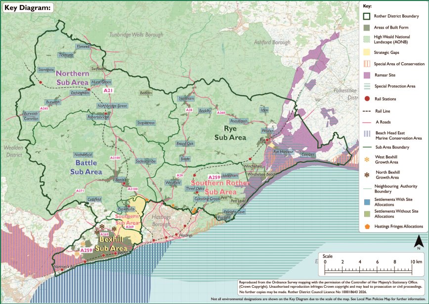
2.39The spatial strategy broadly seeks to focus growth in and around existing settlements, helping to protect the character of the countryside. Existing settlements contain a comparatively good level and concentration of services and facilities, along with opportunities for people to access them using public transport and active travel. Whilst it is recognised that not all settlements benefit from the same level of such provision, focussing new development within them can support the delivery of new or improved local services along with supporting infrastructure. Key strategic locations for the spatial strategy include Bexhill, as the most sustainable town in the district, as well as the historic market towns of Battle and Rye. The fringes of Hastings and villages dispersed throughout the district, including some close to the A21 transport corridor, will also play a role in accommodating new development.
2.40The rural setting of the district comprises differing landscapes and settings - from the network of villages and hamlets within the High Weald National Landscape, to the coastal areas connected to the main towns. It is important the growth in rural communities enables improvements to sustainable transport options, allowing residents access to neighbouring communities to share facilities and services. While the district currently has many isolated dwellings, farmsteads and commercial activities within the countryside outside of defined settlement areas, the spatial strategy prioritises growth within or on the edge of existing well defined built-up areas with good access to services, in order to facilitate sustainable development. In line with national policy, where opportunities for appropriate and policy compliant brownfield redevelopment arise these will be considered favourably. This will allow for windfall development to come forward on a site-by-site basis.
The High Weald National Landscape
2.41The High Weald National Landscape (HWNL) is a national asset and an integral part of Rother’s local character and distinctiveness. The HWNL is a designated Area of Outstanding Natural Beauty, which covers some 83 per cent of the district’s area. National Landscapes have the highest form of protection in relation to landscape and scenic beauty. Under Section 85 of the Countryside and Rights of Way Act (2000), as amended,[42] public bodies have a legal duty to “seek to further” the statutory purpose of protected landscapes (namely, the conservation and enhancement of their natural beauty).
2.42The NPPF confirms that great weight should be given to conserving and enhancing the landscape and scenic beauty of National Landscapes. Further, it states that major development within them should only be permitted in exceptional circumstances and where it can be demonstrated that the development is in the public interest, having regard to the need for the development, the cost of, and scope for developing outside the designated area, and any detrimental effects.[43]
2.43The Local Plan has been prepared having regard to the legislative and policy framework for National Landscapes, together with the High Weald AONB Management Plan. The spatial strategy responds to these by seeking to focus development away from it. However, given the significant identified needs for housing and other types of development in the district over the plan-period, as well as the need to secure the long-term viability and sustainability of settlements within it, it is necessary make provisions for a limited amount of new development in this area. Site allocation policies are included in the Local Plan which help give effect to the spatial strategy. Allocations within the HWNL have been subject to rigorous assessments, considering their impact on the National Landscape, and include detailed requirements to ensure new development on them is appropriate. Whilst acknowledging that there are a small number of site allocations that will constitute major development in the HWNL, it is considered appropriate to include them in the context of meeting identified local housing needs.
2.44Further requirements for development proposals within or likely to affect the HWNL are set out in Policy LAN2 (High Weald National Landscape).
Growth opportunities for the sub-areas
2.45Figure 2.6 below provides a summary of the growth opportunities and development potential of Rother and the five sub-areas, established by site allocations within the Local Plan (and the housing requirement provided for the Rye Neighbourhood Plan Review)[44]. The table reflects the outcomes sought by the spatial strategy.[45] Chapter 8 provides further details on the boundaries, vision and planning policies for each of the sub-areas (including site allocations).
Figure 2.6: Summary of Growth Opportunities for Sub-Areas (as reflected in site allocations)[46]
|
Sub Area – Total Growth |
Total housing (dwelling nos) |
Total employment floorspace (sqm) |
|
Bexhill |
4,474 |
78,225 |
|
Southern Rother and the Hastings Fringes |
377 |
6,000 |
|
Battle and surrounding settlements |
800 |
12,971 |
|
Rye and the eastern settlements |
737 |
18,480 |
|
Northern Rother settlements |
799 |
4,200 |
|
TOTALS |
7,197 |
119,876 |
Policy INF1: Strategic Infrastructure Requirements Comment
|
Status |
Strategic |
|
Priorities |
Live Well Locally, Green to the Core, Thriving Local Economy |
|
Strategic Objectives |
7, 8 |
|
Infrastructure capacity and provision
Funding mechanisms
Exceptions
Governance and delivery
|
|
|
Key evidence and or guidance:
|
|
2.46National planning policy requires local planning authorities to ensure that sufficient infrastructure is provided to support sustainable development and growth. This policy provides the mechanism to ensure that growth in Rother is sustainable and adequately mitigated, in compliance with standard legal tests and the Community Infrastructure Levy (CIL) Regulations.
Context
2.47Future housing and employment growth across Rother, combined with projected demographic shifts, will clearly place pressure on existing infrastructure capacity. The unique geography of the district with distinct rural communities, historic market towns, and coastal areas—presents specific challenges in delivering utility, transport, education, and healthcare networks. Without robust mechanism controls, cumulative minor developments risk overwhelming local systems, while major strategic sites require strict phasing to prevent infrastructure lag.
2.48The Council’s Infrastructure Delivery Plan (IDP) identifies the type, location, delivery timeframe, and funding mechanisms of the infrastructure required to support planned growth. This will be a ‘live’ document that is updated regularly. This document is a critical part of the Local Plan evidence base.
2.49It is important to note that its delivery is not always in full control of the Council. It is dependent on partnership working between a variety of public, private and voluntary sector agencies known as ‘infrastructure providers’. As such the Council is heavily reliant on the expertise and advice of these external providers to determine what is needed to support development in the plan and to deliver the required infrastructure.
2.50The Council has undertaken engagement with key infrastructure providers and organisations to understand their various strategies and programmes and to start identifying the infrastructure required to support proposed development, as well as to seek their views on the impacts of our development strategy on infrastructure needs for the district. Ongoing engagement will be required to ensure the effective delivery of infrastructure in the right place at the right time.
Infrastructure planning
2.51Infrastructure can be described as the supporting services, facilities and utilities that are necessary to support growth and development across the district. It can be strategic in nature, supporting growth across the whole or part of district, or it can be local in nature, supporting specific development sites. The term is wide reaching and comprises physical, social and green/blue infrastructure (open space and water), ranging from telecommunication facilities through to public transport measures, sports pitches, schools and health facilities.
2.52“Necessary infrastructure” in this policy refers to that required to make a development acceptable in planning terms. They can be physical infrastructure (e.g., transport links, utility connections), social infrastructure (e.g., health facilities, school places), or green and blue infrastructure (e.g., open space).
2.53 It is anticipated that the majority of minor developments will meet their infrastructure obligations through standard CIL payments where liable, or utility connection processes. Section 106 planning obligations will only be sought from minor schemes where necessary to make the development acceptable in planning terms.
2.54Section 106 planning obligations and infrastructure contributions can only be used to mitigate the impacts generated by the proposed development itself. They cannot be sought to resolve pre-existing infrastructure deficits or historic service shortfalls (such as existing GP waiting times or existing school capacity constraints). Where existing infrastructure is under strain, applications will be assessed on whether the developer has adequately mitigated the specific additional demand created by their proposed scheme.
2.55Developers and landowners are encouraged to engage early with the Council, statutory consultees[47] and specific consultation bodies[48] at pre-application stage to proactively address the infrastructure requirements alongside compliance with external statutory policies, strategies, and guidance.
Delivery
2.56Infrastructure delivery will be secured through a combination of direct delivery by developers, Section 106 planning obligations, conditions attached to planning permissions, Section 278 agreements and unilateral undertakings, the CIL charging regime, and external funding sources.
2.57CIL will be allocated according to the Council’s internal CIL governance protocols and spending priorities. The Council’s annual Infrastructure Funding Statement will state the type of infrastructure for which development contributions will be sought and will detail overall spend and delivery of infrastructure at a district level. Parish Councils have their own duty to publish details of their spend and delivery of infrastructure from CIL payments.
Exception and clawback
2.58Where a viability exception is justified and accepted, the Council will protect the public interest by requiring viability review mechanisms (clawback clauses) within the S106 agreement. These legal clauses mandate a reassessment of the development's economics at specific milestones (e.g., prior to completion or phase transitions). If market conditions improve, costs fall, or sales values rise beyond the initial projections, the clawback mechanism will capture some of the surplus to fulfil the deferred infrastructure contributions or financial obligations. Any Viability Assessment will be subject to an independent scrutiny by Council-appointed experts at the applicant’s cost.
Policy INF2: Transport Connectivity, Decarbonisation & Mitigation Comment
|
Status |
Strategic |
|
Priorities |
Live Well Locally, Green to the Core, Thriving Local Economy |
|
Strategic Objectives |
7, 8 |
|
Sustainable patterns of movement
Highway safety and network capacity
Securing mitigation and funding
|
|
|
Key evidence:
|
|
2.59 The NPPF requires development to prioritise sustainable transport modes and safeguard network safety and capacity. Department for Transport (DfT) Circular 01/22 (Strategic Road Network and the Planning System) sets out how impacts on national trunk roads must be managed. Policy INF2 also aligns with the overarching vision of the East Sussex Local Transport Plan 4 (LTP4 2024-2050) and translates these national and regional requirements into a local framework. It aims to decouple development from unsustainable private car use, maximise travel choice, protect network safety, and ensure necessary site-specific mitigation is fully funded.
Rother’s challenges
2.60Rother’s rural-urban geography and dispersed settlements drive a high reliance on private cars. The Strategic Road Network, specifically the A21 and A259 corridors, therefore, often suffers from capacity constraints. Evidence from the East Sussex Local Transport Plan and the Local Plan Transport Assessment shows that while single developments may have negligible impacts, their cumulative effect will degrade highway safety and network efficiency if left unmitigated.
2.61The Local Plan Transport Assessment highlights the scale of this car dependency. Private vehicles account for 69% of all commuting trips to and from the district. This reliance is even starker for cross-boundary travel: about 40% of all local commutes are bound for Hastings, Wealden, Eastbourne, and Kent, and over 80% of these journeys are made by car. Meanwhile, public transport is used for just 3% of trips within Rother, lagging far behind neighbouring districts like Hastings (10%) and Eastbourne (9%).
2.62Shifting commuters toward sustainable travel is complicated by Rother’s unique combination of physical, operational, topographical and demographic challenges:
- On the roads, key junctions on the A21 and A259 corridors are already operating at or near capacity during peak hours. On the tracks, the Hastings rail line is capped by power supply constraints, while the Marshlink line remains restricted by single-track sections and un-electrified diesel services.
- In our rural and northern settlements, hilly terrain and a lack of footways and cycleways naturally discourages walking and cycling.
- Rother, and Bexhill in particular, has an older average population compared to other areas of the county. This, together with the topography and rural nature of much of the district, makes accessibility and the uptake of active modes more challenging.
- With road transport driving nearly 45% of the district's carbon emissions, securing developer-funded infrastructure mitigation is critical to meeting the Council's target of carbon neutrality by 2030.
Sustainable patterns of movement
2.63To comply with this policy, development proposals should prioritise active travel and public transport over private vehicular movements. Further requirements are set out in Policies LWL2 (Facilities and Services for Residential Development), LWL3 (Active Travel, Public Transport Connections & Services Outside the Site) and LWL4 (Active Travel & Public Transport Within Sites).
Highway safety and network capacity
2.64Proposals likely to materially impact the A21 or A259 must be accompanied by evidence of early technical engagement with National Highways regarding the Strategic Road Network (SRN).
2.65Development proposals must fully account for cross-boundary transport impacts. Where a development potentially impacts the highway network beyond Rother’s administrative area, applicants must actively consult with East Sussex County Council, Kent County Council and relevant neighbouring authorities to ensure the wider impacts are sufficiently mitigated.
2.66Applicants should also refer to the requirements set out in LWL3 regarding the content of the Transport Assessment and/or Statement. Applicants must also adopt the “Monitor and Manage” and “Vision and Validate” principles, in accordance with DfT Circular 01/22 and national planning policy.
Securing mitigation and funding
2.67Transport mitigation to address impacts from development will be legally secured via planning conditions and Section 106 and Section 278 agreements under the Highways Act 1980 (or any subsequent updated version). Transport mitigation refers to the physical infrastructure works (such as junction modifications, traffic calming, cycleways, or pedestrian crossings), contributions to public transport, as well as behavioural initiatives required to eliminate, reduce, or offset the traffic impacts of a development, or to promote sustainable patterns of movement.
2.68To prevent conflict or duplication with Rother's CIL framework, funding for transport mitigation is delineated across three distinct mechanisms:
- CIL funding: Allocated only towards strategic, district-wide transport infrastructure to address cumulative traffic growth and to support development. This is subject to the Council’s internal CIL governance protocols and spending priorities.
- Standard developer contributions (S106 and S278 agreements): Strictly restricted to site-specific mitigation and access required to make an individual site acceptable in planning terms, delivered at the outset or agreed phase of development.
- Monitor and Manage obligations (secured via S106 agreements): Used where transport obligations are contingent on monitored performance across the construction, build-out, and operational phases. Transport impacts of development sites will be monitored against agreed Travel Plan targets throughout the development lifecycle, with interventions triggered when the modal share or traffic targets are breached. S106 agreements will be used to secure developer funding towards Travel Plan auditing, administrative costs, and pre-agreed contingency fallback mitigations.
2.69To protect the public interest against delivery failure, the Council will consider securing planning obligations through performance bonds (contract bonds) prior to the commencement of physical highway works. A performance bond acts as a financial guarantee provided by an approved third-party surety, such as a bank or insurance company. In the event that a developer defaults, goes into liquidation, or fails to complete the agreed highway works, the bond enables the Council or Highway Authority to draw down the secured funds to finish the infrastructure themselves, ensuring no financial liability falls on the public purse.
2.70To coordinate Monitor and Manage transport measures, the Council will convene a Transport Infrastructure Management Group (TIMG) (nominally titled). The TIMG will include representatives from Rother District Council, East Sussex County Council, National Highways, and other relevant key delivery partners.
2.71Where a Monitor and Manage strategy is approved and implemented, to mitigate financial exposure and protect public resources, the ongoing technical and administrative costs of collecting and auditing the site’s trip monitoring data must be fully funded by the developer. Additionally, the Council may require contributions into ring-fenced escrow accounts to secure contingency mitigation. Contingency mitigation refers to pre-agreed fallback measures, such as physical junction modifications, highway capacity improvements, or public transport service enhancements, required if the site's sustainable travel measures fail to meet targets. Both the performance thresholds and the specific fallback mitigations must be identified through the initial Transport Assessment and contractually agreed upfront within the legal agreement. This ensures that funds can be immediately deployed if post-occupation monitoring reveals that sustainable travel targets have been missed.
Policy SS2: Development Boundaries Comment
|
Status |
Strategic |
|
Priorities |
Green to the Core, Live Well Locally |
|
Strategic Objectives |
7, 11 |
|
|
|
Key evidence or guidance:
|
|
2.72Development boundaries differentiate between areas of built form within sustainable towns and villages, where further development (including redevelopment or intensification) will be acceptable in principle, and the countryside.
2.73Development boundaries are a key tool to positively focus growth on sustainable settlements and the networks and clusters of villages identified in the development strategy. This approach protects the surrounding countryside around them from unnecessary and intrusive development. The substantial High Weald National Landscape coverage of the district is a further key justification for carefully managing development in the countryside.
2.74Within development boundaries, development will principally be on allocated and identified sites, together with other sites where proposals accord with relevant Local Plan policies. There is a presumption that infilling, redevelopment and changes of use will be acceptable subject to other policies of the Local Plan. This process of ‘gentle densification’ will help to support sustainable communities to “Live Well Locally”. Proposals within development boundaries are still subject to other policies to ensure that development does not adversely impact on other interests of acknowledged importance. Policies LWL1 and LWL5 are particularly relevant to ensuring that such development makes efficient use of land and is designed so as not to prejudice future connectivity or, where relevant, the coordinated development of adjoining land.
2.75 While land outside development boundaries is regarded as ‘countryside’ for planning policy purposes, it does include some villages, hamlets and farmsteads. A countryside location does not prevent appropriate development. The potential for development outside development boundaries to support vital rural communities and also conserve or enhance its intrinsic qualities is recognised. For example, Policy HOU11 (New Dwellings in the Countryside) recognises that there are some limited circumstances where new dwellings may be permitted in the countryside, including dwellings necessary to support farming and other land-based industries. In exceptional circumstances rural needs for affordable housing or specialist housing for older people may be met through Policies HOU3 (Rural Exception Sites & Community-led Development) and Policy HOU7 (Specialist Housing for Older People) respectively. There are also specific policies to promote a sustainable rural economy, including Policies ECO9 (Agricultural Development & Forestry) and ECO10 (Agricultural Diversification) in relation to the requirements of farming and agricultural diversification, and Policies ECO7 (Tourism Activities, Facilities & Accommodation) and ECO8 (Holiday Sites & Accommodation) in relation to tourism.
2.76Development boundaries form policy lines and they do not necessarily represent the exact edge of settlements as such. While development boundaries will normally follow physical boundaries, on occasion, the full depth of property curtilages may be excluded to make clear a policy statement that back land or in-depth development is unacceptable, often because of its additional visual or amenity impact. This approach is consistent with the National Planning Policy Framework, which highlights the need to recognise ‘the intrinsic character and beauty of the countryside’ and the need to manage patterns of growth to realise opportunities for walking, cycling and use of public transport, with significant development focused on locations which are or can be made sustainable.
2.77 Figure 2.7 provides a table which shows the settlements which have development boundaries. Note that all of these are defined through this Local Plan other than Rye, which is in the Rye Neighbourhood Plan. Development boundaries are illustrated on a plan for each settlement in Chapter 8 of this Plan, although due to the scale, these plans are indicative. For further detail please see the Policies Map.
Figure 2.7: Settlements with Development Boundaries
|
Bexhill |
Battle |
|
Hastings Fringes |
Rye |
|
Beckley |
Burwash |
|
Brede and Cackle Street |
Burwash Common |
|
Broad Oak |
Burwash Weald |
|
Camber |
Crowhurst |
|
Catsfield |
Flimwell |
|
Etchingham |
Netherfield |
|
Guestling Green |
Hurst Green |
|
Fairlight Cove |
Peasmarsh |
|
Icklesham |
Robertsbridge |
|
Iden |
Sedlescombe |
|
Northiam |
Stonegate |
|
Pett |
Ticehurst |
|
Rye Harbour |
|
|
Staplecross |
|
|
Three Oaks |
|
|
Westfield |
Policy SS3: Strategic Green Gaps Comment
|
Status |
Strategic |
|
Priorities |
Green to the Core, Live Well Locally |
|
Strategic Objectives |
3, 4 |
Bexhill and Hastings/St Leonards Strategic Green Gap
Crowhurst and Hastings/St Leonards Strategic Green Gap
Battle and Hastings/St Leonards Strategic Green Gap
Fairlight and Hastings Strategic Green Gap
Rye and Rye Harbour Strategic Green Gap
|
|
|
Key evidence or guidance:
|
|
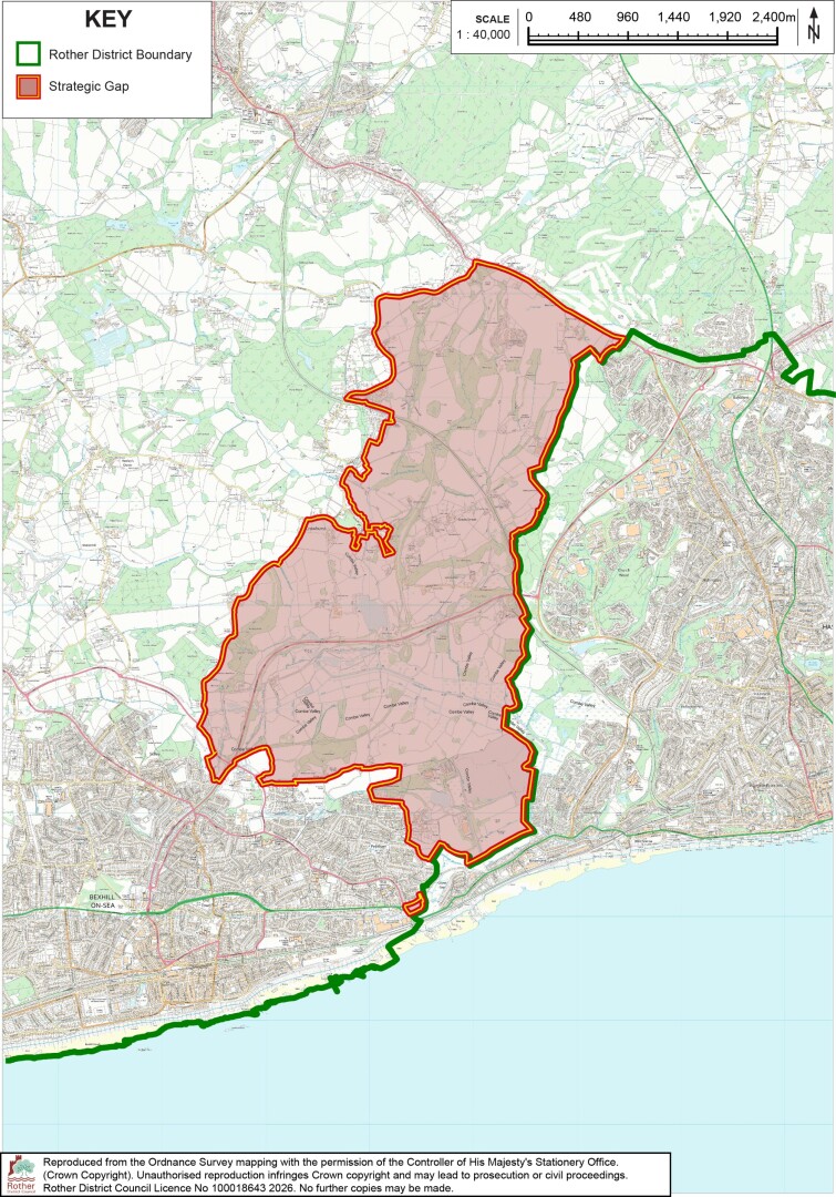
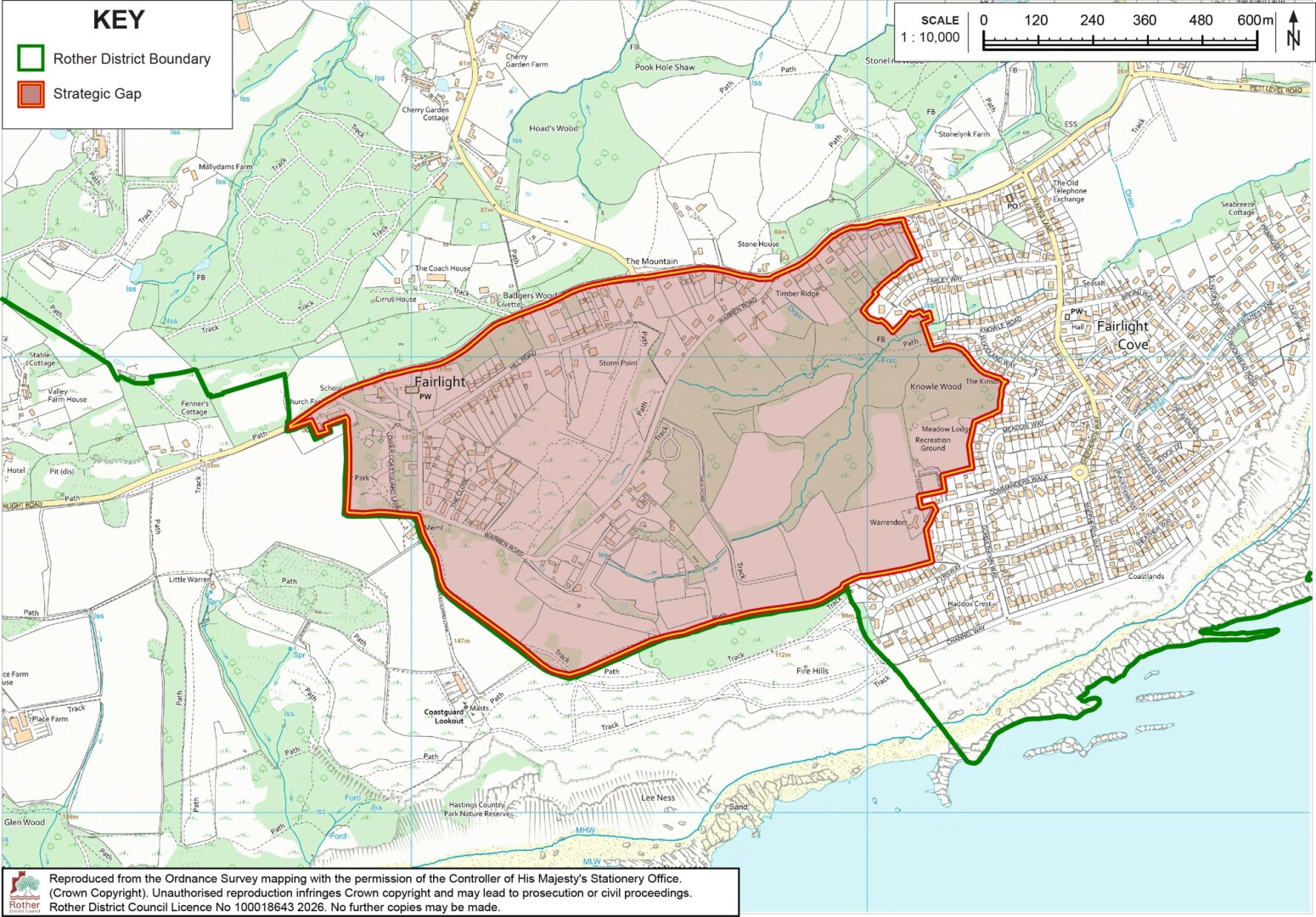
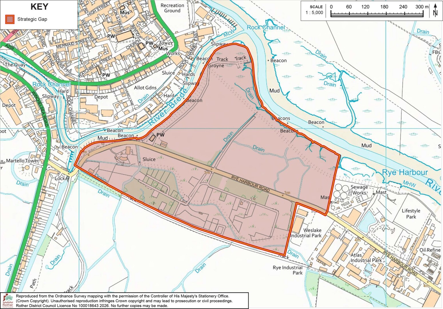
2.78Strategic Green Gaps are important in terms of guiding the location of development. Development within these gaps is strictly limited to maintain their openness, although the policy does allow for unobtrusive development which does not detract from the openness of the area having regard to the specific objectives of the strategic green gaps.
2.79The policy specifically allows for the development of a solar farm at Pebsham Landfill site within the Bexhill and Hastings/St Leonards Strategic Green Gap. This is further detailed at Policy GTC6 (Renewable & Low Carbon Energy). This does not give a blanket acceptance to solar farms within the Strategic Green Gaps, as any such proposal would need to be considered on its merits in line with the requirements of the policy, however the Pebsham Landfill site offers a unique opportunity to provide for this development on a temporary basis while the landfill itself settles and remains unavailable for other uses.
2.80The location and extent of the Strategic Green Gaps are illustrated on the following three maps, Figure 2.8 to Figure 2.10. Please note that due to scale, these maps are indicative only. For further clarity please see the Policies Map.
Policy SS4: Strategy for the Countryside Comment
|
Status |
Strategic |
|
Priorities |
Live Well Locally, Green to the Core, Thriving Local Economy |
|
Strategic Objectives |
2, 3, 4, 6, 7, 9 |
|
|
|
Key evidence or guidance:
|
|
2.81As a predominantly rural district, the countryside of Rother district is a defining characteristic. The term countryside refers to those areas outside of defined Development Boundaries, as established by Policy SS2 (Development Boundaries) and illustrated on the Policies Map. National planning policy provides a clear direction that the intrinsic character and beauty of the countryside should be safeguarded and sets out the different types of development that are acceptable outside of development boundaries.
2.82This policy, together with other Local Plan policies, seeks to safeguard the beauty and intrinsic character of the countryside, including its landscape and heritage character, whilst supporting prosperous communities. It provides the basis for ensuring that the countryside is protected and maintained as a working landscape that supports land-based agricultural and related rural activities, together with tourism, through sustainable land management practices. It also acknowledges the important role that the network of green and blue infrastructure has in terms of the countryside’s ecological and amenity value. As well, the policy acknowledges the settlements and communities dispersed throughout the countryside, and the need to secure their long-term vitality by provision of limited and new high-quality development, such as housing and social infrastructure, which is sensitively designed and appropriate to its unique local context.
Policy SS5: Strategy for Accommodation Needs of Gypsies, Travellers and Travelling showpeople Comment
|
Status |
Strategic |
|
Priorities |
Live Well Locally, Green to the Core |
|
Strategic Objectives |
|
|
|
|
Key evidence and or guidance:
|
|
2.83The national Planning Policy for Traveller Sites (PPTS, updated 2024) requires local planning authorities to identify, and update annually, a supply of specific, deliverable sites sufficient to provide 5-years’ worth of sites against their locally set targets; and a supply of specific, developable sites or broad locations for years 6-10, and where possible, for years 11-15.
2.84The outstanding need figures for Rother, which derive from the East Sussex Gypsy and Traveller Accommodation Needs Assessment[50], take account of new permissions granted in the interim, are reflected in the strategy above.
2.85Sites identified to meet the need must be deliverable, either through being (or proposed to be) publicly owned, owned by gypsies/ travellers, have a willing landowner or, possibly, be part of a comprehensive development scheme that addresses a wider range of housing need.
2.86Site allocations are set out in Chapter 8 of the Local Plan. Pitches have been identified through the site allocations, which will contribute to meeting the supply required between years 1 and 10 of the Plan.
Policy SS6: Neighbourhood Plans & Parish Priority Statements Comment
|
Status |
Strategic |
|||||||||||||||||||||||||||||||||||||||||||||||||||||||||||||||||
|
Priorities |
Live Well Locally, Green to the Core |
|||||||||||||||||||||||||||||||||||||||||||||||||||||||||||||||||
|
Strategic Objectives |
2, 10 |
|||||||||||||||||||||||||||||||||||||||||||||||||||||||||||||||||
Housing targets
Housing supply and delivery pending Neighbourhood Plans
|
||||||||||||||||||||||||||||||||||||||||||||||||||||||||||||||||||
|
Key evidence and or guidance:
|
||||||||||||||||||||||||||||||||||||||||||||||||||||||||||||||||||
2.87In Rother, Neighbourhood Development Plans (or Neighbourhood Plans) are prepared by parish and town councils. They set out a shared vision and planning policies for local areas. Neighbourhood Plans that are ‘made’ (adopted) form part of the Statutory Development Plan. There are nine such Neighbourhood Plans in the district[54], as set out earlier in the plan.
2.88The Levelling Up and Regeneration Act 2023 introduced and sets provisions for Parish Priority Statements. These provide another way for communities to set out a vision and priorities for the future of their local areas. Whilst Parish Priority Statements do not form part of the Development Plan, they can nonetheless help to inform the preparation and implementation of planning policies. Parish and town councils are encouraged to have regard to the Local Plan when preparing or updating their Neighbourhood Plans and Parish Priority Statements, as this can help to ensure coordination in the overall approaches to planning and investment in their local areas.
2.89The NPPF sets out that the Local Plan should include strategic policies which set out a housing target for adopted Neighbourhood Areas to ensure they make a contribution to the overall housing requirement for the district (or an indicative figure in cases where it is not possible to provide a target). This policy sets outs out housing targets for the relevant areas. The NPPF makes clear that Neighbourhood plans should not promote less development than set out in the strategic policies for the area or undermine those strategic policies.[55]
[21] Our Council Plan 2025-2029, Rother District Council.
[22] Planning and Compulsory Purchase Act 2004 (as amended), Section 19.
[23] Rother District Council declared a Climate Emergency in September 2019.
[24] Carbon sequestration is the long‑term capture and storage of atmospheric carbon dioxide in plants, soils, oceans, or geologic formations, achieved naturally or through technologies such as carbon capture and storage.
[25] NPPF (2024), Paragraph 61. Further details on the standard method are set out in the Government’s Planning Practice Guidance.
[26] Figure correct as of 2026. Inputs factored by standard method are expected to be updated annually by the Government (including ‘housing stock estimates’ and ‘affordability ratios’ for the district) and may result in the calculation of a revised local housing need figure, which will be monitored.
[27] PPG Reference ID: 2a-040-20241212
[28] This is, in effect, the number of additional dwellings expected to come forward on large sites (5 dwellings plus) where development has commenced (as of August 2026).
[29] Large sites (5 dwellings plus) with an extant planning permission but where development has not commenced (as of August 2026) have been included as site allocations, rather than commitments.
[30] NPPF (2024), Paragraph 75.
[31] Rother Housing and Economic Land Availability Assessment.
[32] NPPF (2024), Paragraph 86.
[33] This is a forecast-led figure. In line with the NPPF and PPG, the study also sets out projections based on past completion trends, however it advises that these should be treated as a contextual indicator rather than a replacement for the forecast-led assessment.
[34] NPPF (2024), Paragraph 90.
[35] East Sussex GTAA, 2022. An update to the GTAA is in progress and will provide the latest assessment of need to the end of the plan period of 2042; however, at the time of publication of this Regulation 19 document the GTAA Update has not been finalised.
[36] The GTAA 2022 pre-dates changes to the definition of “gypsies and travellers” in national planning policy although the “ethnic definition” used in the Assessment aligns with the current government definition (i.e. based on the ethnic identity of gypsies and travellers, not taking into account whether they have permanently ceased to travel or not). The need figures detailed here are those of the “ethnic” definition.
[37] East Sussex GTAA, 2022.
[38] 1 April 2021
[39] Taking account of pitches delivered/permitted between 1 April 2021 and October 2025.
[40] These include, for example, the Sustainability Appraisal, Habitats Regulations Assessment, Strategic Flood Risk Assessment, and Landscape Sensitivity Study.
[41] Main town centres uses are defined by the NPPF.
[42] Amended by Section 245 (Protected Landscapes) of the Levelling Up and Regeneration Act 2023.
[43] NPPF (2024), Paragraphs 189-190.
[44] Note that the figures in this table do not include completions or commitments (as defined in footnotes 27 and 28) or windfalls, these are instead counted for the whole district at paragraph 2.13.
[45] Figures are provided for housing and employment. Figures for retail are not included as evidence indicates there is no need for additional floorspace at the district level, however some site allocations make provision for this.
[46] The total housing no. for Rye and the eastern settlements includes the housing requirement of 325 dwellings provided for the Rye Neighbourhood Plan Review (2026). The total employment figure for Rye and the eastern settlements includes employment floorspace expected to come forward as a result of identified sites within the Rye Harbour Employment Area as detailed in the HELAA, rather than specific site allocations.
[47] Statutory consultees are defined under Schedule 4 of the Town and Country Planning (Development Management Procedure) (England) Order 2015
[48] Specific consultation bodies are defined under Regulation 2 of the Town and Country Planning (Local Planning) (England) Regulations 2012
[49] The Local Plan period is to 2042. The current evidence (East Sussex GTAA, 2022) considers the period to 2040. From 2025 this does allow for 15 years, in line with the requirements of the national PPTS. The GTAA Update will address provision over the plan period.
[50] East Sussex GTAA, 2022.
[51] Including sites not yet completed or commenced (outstanding dwellings on commenced sites are counted as commitments, as per footnote 27). Excluding any sites allocated in the NP for less than 5 dwellings, and excluding sites allocated in the NP that are not expected to come forward.
[52] Comprised of additional sites allocated through the Local Plan (including any previous Local Plan allocations carried forward) and additional capacity included in NP allocations carried forward.
[53] Excluding completions 1 April 2025-31 March 2026, and excluding commitments as defined in footnotes 27 and 28.
[54] As of August 2026.
[55] NPPF (2024), Paragraph 30.
