
Rother Local Plan 2025-2042 Regulation 19 (pre-submission) version September 2026
Chapter 13: Rye and the Eastern Settlements Sub-Area: Vision, Strategy and Site Allocations
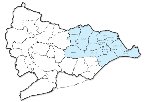
Includes the parishes of Beckley, Brede, Camber, East Guldeford, Icklesham (east), Iden, Northiam, Peasmarsh, Playden, Rye Foreign, Rye and Udimore
Vision for Rye and the Eastern Cluster of Settlements Comment
The important historical character of Rye will be preserved and enhanced, maintaining a strong retail and services core with access to sustainable green tourism and leisure opportunities. Areas at risk from flooding and sensitive environmental areas will be protected from inappropriate development and the high-quality biodiversity and landscape designations will be sensitively managed and enhanced, including community access, through biodiversity net gains from development.
The key employment areas within Rye Harbour will be retained, along with other commercial areas across the town. This includes maintaining the viability of the Port of Rye as a working harbour, while having regard to protecting the integrity of internationally designated habitats. Key tourism areas such as Camber will be promoted through improved accessibility to reduce the dependency on the car, including better utilisation of existing cycle and pedestrian routes.
The eastern cluster of settlements will be better connected by sustainable transport infrastructure, with Rye acting as a key transport hub, and local economies will continue to grow, respecting the historic development pattern of rural communities over time. The strengthened connections to Rye as a sustainable market town, will allow for sensitive development in adjoining villages. The Rye Neighbourhood Plan will continue to allocate housing and employment sites in Rye and Rye Harbour.
There is potential to deliver 737 dwellings and 18,480 sqm of employment floorspace across the Rye and Eastern Settlements Cluster sub-area.
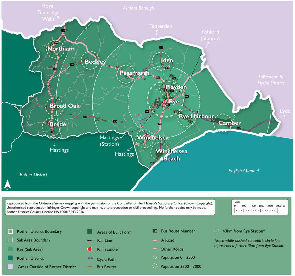
13.1Rye and the eastern settlements cluster include the parishes of Beckley, Brede, Camber, East Guldeford, Icklesham, Iden, Northiam, Peasmarsh, Playden, Rye, Rye Foreign and Udimore, and the settlements within them.
13.2Rye is the only town in this sub area, with all eleven satellite parishes relying on it for many services. This is reflected in the housing target for Rye (provided for the Rye Neighbourhood Plan Review, 2026), with Rye having the highest total of all the parishes in the eastern part of the district. Rye is a historic market town and the main service and employment centre in eastern Rother.
13.3The area surrounding Rye is heavily constrained physically by the High Weald National Landscape (NL) to the north and west, and low-lying areas at risk of flooding and designated for their habitat value to the south and east, including the Dungeness complex of internationally protected habitats sites. Some parts of Rye’s built-up areas encroach into other adjacent parishes (Rye Foreign and Playden). Rye also functions as a key transport hub for travel outside of the district, including by rail to London via Ashford, and Eastbourne via Hastings.
13.4No site allocations are included in the Local Plan for Rye. This is because the housing requirement has instead been provided for the Rye Neighbourhood Plan (NP) Review, which was subject to Regulation 14 consultation in 2026 and which is, at the time of writing, progressing towards Regulation 16. The draft NP Review proposes to meet the housing requirement through site allocations.
13.5While some settlements link radially to Rye, there is also a network of settlements which form a cluster, as shown in the key diagram above, with Rye as a key destination. This cluster is supported by existing bus services. A sensitive level of growth can be delivered in the cluster of settlements that connect to Rye as a main transport hub. Associated sustainability improvements will be required to local services and facilities, as well as active travel measures.
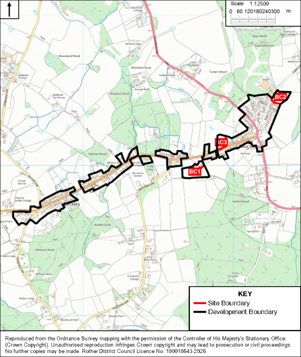
13.6Three sites have been allocated in Beckley, a historic village with ribbon development straddling an ancient east-west route in the High Weald NL, located some 7.5km northwest of Rye. The village has landscape constraints, being located within the High Weald NL, and is effectively bound north and south by the Rother, Brede and Tillingham Woods Biodiversity Opportunity Area. It has a primary school, village hall, recreation ground, play area, church, and a public house in nearby Clayhill. However, residents are reliant on the larger neighbouring settlements of Peasmarsh and Northiam for shops, doctor and dentist.
13.7Three sites allocated in Broad Oak (Brede parish). Broad Oak is a small village, approximately 9km west of Rye and 12km north of Hastings. It sits wholly within the High Weald NL, and the village is sited on a crest, with the land falling away most markedly to the southern open vistas of the Brede river valley. Broad Oak has a range of services including a primary school and doctors surgery. The village is served by several bus services although as no service has at least 10 buses per day, the public transport connections are considered to be limited.
13.8Camber has three small site allocations, two carried forward from the previous Local Plan. The settlement is in the far east of the district, not far from the Kent border. Once a quiet place of scattered bungalows and coastguard cottages, the village has seen a lot of development since World War 2 with the building of large holiday camps and residential dwellings. Whilst the services currently available are considered to be limited, the sites will contribute to the vitality and sustainability of the village.
13.9Rye Harbour (within Icklesham parish) is a satellite village to Rye and is located to the southeast of the town. It includes a large industrial area that straddles Harbour Road for 1.3km before the residential section of the village is reached. Although Rye Harbour has close economic links with nearby Rye, it is considered a distinct settlement, which is consolidated by the existing Strategic Gap between the two settlements. While outside of the AONB, Rye Harbour has significant environmental constraints to further development. All land surrounding the settlement is either protected by international designations (SAC/SPA/Ramsar) or is within Flood Zone 3, or both. In addition, Rye Harbour Local Nature Reserve directly adjoins the settlement to the south-west.
13.10The existing employment area at Rye Harbour provides a substantial amount of employment and is significant for the eastern area of the district. It includes a long-established concentration of industrial uses, including some heavy industry such as an oil refinery. Subject to safeguarding the surrounding habitats sites and working within the limitations of the areas of flood risk and the local road network, the Local Plan takes a supportive approach to further intensification of the Harbour Road employment area. There is only one allocated housing site within Rye Harbour, brought forward from the previous Local Plan, which will contribute to the on-going vitality of the area.
13.11Iden is a small rural village approaching some 400 people, situated to the north of Rye. It is within the eastern end of the district, with the Kent border being 1.1km to the north. The settlement is principally linear in form, and located wholly within the High Weald NL, set on topography that gradually slopes down to the lower reaches of the Rother. It has limited services. Two small sites are allocated for residential development, which will support the vitality of the village.
13.12Northiam is one of the most populated villages in the district, with an estimated population of 1,903, and supports a reasonable range of services and facilities. The village lies along a generally north to south running ridge, situated on the A28, and is 10.5km northwest of Rye. It is wholly within the High Weald NL and contains a substantial number of buildings listed for their architectural or historic interest and a Conservation Area in the southern part of the village. The landscape features long dramatic views across valleys from the enclosing ridges and spurs, which is a key factor in limiting the number of sites suitable for development. Two small sites are included as allocations; one carried forward from the previous Local Plan.
13.13Peasmarsh is situated within the north-east of the district, 5.5km from Rye. Compared to most villages of its scale, it has a less defined village centre, although it does have a range of services including a primary school and pre-school, pub and a superstore (which also contains a post office, café, pharmacy and petrol filling station). The parish is within the High Weald National Landscape and the only suitable sites for development are within or adjacent to the village itself. Five sites have been allocated in the parish, including one small Neighbourhood Plan allocation carried forward.
13.14Playden is a small, rural village to the north of Rye, east of the A268. It is located outside the HWNL, and the main settlement is not affected by flooding. It does, however, contain a number of heritage assets including the Grade I listed parish church, and lanes away from the A268 are narrow and winding. While services in Rye are relatively close at around 1km, pedestrian connections to Rye along the A268 could be improved as there are narrow/missing footways in places. Two small sites are allocated for residential development in Playden.
13.15The settlements of East Guldeford, Icklesham (Winchelsea Beach), Rye Foreign and Udimore do not have include site allocations in the Local Plan. Sites assessed through the HELAA process have been found to be unsuitable for reasons such as flood risk and environmental impacts.
13.16 Figure 13.2 below illustrates the development strategy for Rye and the eastern settlements cluster in terms of the numbers of dwellings and the amount of employment floorspace that is expected to be delivered over the Plan period. These figures have been derived from the total amount of development included in the site allocations, together with the housing figure provided to Rye for the Neighbourhood Plan Review (2026), and the amount of employment floorspace expected to come forward as a result of identified sites at Rye Harbour.
Figure 13.2: Rye and Surrounding Settlements Development Strategy: Housing and Employment
|
Settlement Area |
Total housing (dwelling nos) |
Total employment floorspace (sqm) |
|
Beckley |
50 |
0 |
|
Broad Oak |
109 |
0 |
|
Camber |
15 |
0 |
|
Rye |
325 |
600 |
|
Rye Harbour |
40 |
17,480 |
|
Iden |
25 |
0 |
|
Northiam |
22 |
0 |
|
Peasmarsh |
126 |
400 |
|
Playden |
25 |
0 |
|
Total Growth |
737 |
18,480 |
Sustainability Coding for Settlements (Source: Rother Settlement Study, 2024)
|
Highly sustainable |
Very Good sustainability |
Good sustainability |
Fair sustainability |
Poor sustainability |
Very Poor sustainability |
Beckley and Four Oaks
Parish: Beckley
Policy BC1: Land South and West of Buddens Green, Beckley Four Oaks Comment
The site is allocated for residential development comprising some 20 new dwellings.
Development on this site must:
i. Provide a policy-compliant amount of on-site affordable housing in line with policy HOU2 of the Rother Local Plan;
ii. Include a new vehicular access from Buddens Green and on-site parking which serves the new dwellings;
iii. Include any new highways works outside the site, as recommended by the Highway Authority to improve opportunities for active travel or access by public transport, such as upgrades to the nearby bus stop on Main Street;
iv. Retain existing trees on the southern and eastern boundaries and provide a new hedgerow of native species on the western boundary;
v. Retain and enhance the existing pond to the southwest of the site and provide a minimum 10 metres buffer to any built development including roadways as informed by an ecological survey;
vi. Protect the setting of the Grade II listed buildings, Braeside House and Orchard Cottage, on Main Street.
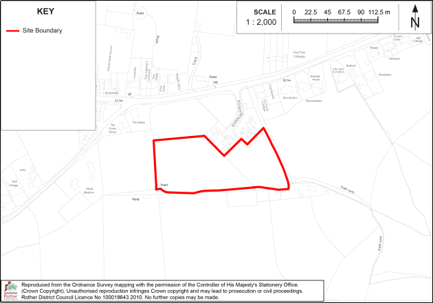
13.17This site comprises a section of a field, south of a small housing estate at Buddens Green. The eastern part of the site was previously allocated for 6 dwellings through the DaSA Local Plan. Additional adjoining land is available to allow an increase in the size of a new residential development. The additional landforms part of a larger field which extends to Main Street to the north however, the northern part of the field is not suitable for development due to risks from flooding, and the allocation only includes the southern section.
13.18 The site is within the Village Area Type, has a site size of 1.49 hectares and an indicative developable area of 0.8 hectares. It is allocated for some 20 dwellings at an indicative residential density of 25 dwellings per hectare.
13.19The site is within the High Weald National Landscape and therefore a sensitive form of development is required in line with Local Plan policies. Two Grade II listed buildings, Braeside House and Orchard Cottage are located on Main Street to the east of the site. The site is enclosed by a mature tree belt to the south and east, limiting the visual impact on the wider landscape, although it is visible from the road to the north. The western boundary has a low risk of surface water flooding. The land to the east has historic field boundaries. A public footpath runs adjacent to the east boundary. The layout of the residential scheme will need to be carefully designed to take account of the shadowing effect of the adjacent trees.
13.20The site is well located in relation to some services, however improvements to pedestrian infrastructure may be required to improve opportunities for active travel and the use of public transport.
Policy BC2: Land East of Hobbs Lane, Beckley Four Oaks Comment
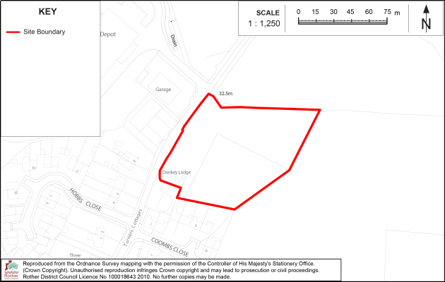
The site is allocated for residential development comprising some 20 new dwellings.
Development on this site must:
i. Provide a policy-compliant amount of on-site affordable housing in line with policy HOU2 of the Rother Local Plan;
ii. Include access from Hobbs Lane to the satisfaction of the Highway Authority;
iii. Provide screening tree and hedgerow planting employing native species on the eastern boundary of the site, and retain and enhance the tree belt on the northern boundary with additional planting;
iv. Provide a new footway alongside Hobbs Lane to link the new development to the existing Hobbs Lane footway; and
v. Take care to respect the amenity value of adjoining residential properties on the southern boundary.
13.21The site is on the northern edge of the village on the eastern side of Hobbs Lane. It comprises an existing brownfield site known as the Former Manroy Engineering Works and a smaller area of adjoining farmland which creates a more logical development area. Development of the brownfield land offers the opportunity to improve the appearance of the site, particularly where it is viewed from Hobbs Lane.
13.22 The site is within the Village Area Type, has a site size of 0.71 hectares and an indicative developable area of 0.5 hectares. It is allocated for some 20 dwellings at an indicative residential density of 40 dwellings per hectare.
13.23The former industrial use of part of the site could have led to ground contamination, and appropriate surveys will need to be undertaken as part of the planning application process, with the need to employ appropriate measures to mitigate any such contamination.
13.24The site is bordered to the south by residential development alongside Hobbs Lane and Coombs Close. Bungalows on the northern side of Coombs Close have a clear view across the site and the amenity of existing and future residents must be protected in designing an appropriate scheme. Regard must also be had to the relationship with the small cluster of commercial/ industrial uses on the opposite side of Hobbs Lane.
Policy BC3: Land west of Oaklea Cottages, Beckley Four Oaks Comment

The site is allocated for residential development comprising some 10 new dwellings.
Development on this site must:
i. Provide a policy-compliant amount of on-site affordable housing in line with policy HOU2 of the Rother Local Plan;
ii. Provide access from Main Street;
iii. Reflect the terraced layout of the adjoining development;
iv. Include access for parking areas that takes advantage of being shared and minimised where possible. On-site turning is a requirement;
v. Retain and enhance the existing boundary hedges and trees to the north, south and west (excepting a section of hedgerow on the southern boundary which would need to be removed to facilitate safe access, which should be minimised as far as possible);
vi. Protect the setting of the Grade II listed buildings, Westfield Cottage and The Cottage;
vii. Ensure future access to existing sewerage infrastructure for maintenance and upsizing purposes.
13.25This site is a small field on the northern side of Main Street, adjacent to a short terrace of dwellings and reasonably well located in relation to services in the village. It is within the Village Area Type, has a site size of 0.48 hectares and an indicative developable area of 0.3 hectares. It is allocated for some 10 dwellings at an indicative residential density of 35 dwellings per hectare.
13.26The site is within the High Weald National Landscape and has historic field boundaries, defined by trees and hedgerows, which should be retained. While Beckley is characterised by undeveloped gaps between areas of built form, this particular site is relatively enclosed in the landscape without the same long views northwards as the adjoining, larger fields.
13.27There are some minor areas at risk of surface water flooding on adjacent land. Southern Water infrastructure crosses site BC3 and may require easements or diversion.
13.28Two Grade II listed buildings, Westfield Cottage and The Cottage, are located on Main Street to the east of the site. To preserve the setting of the listed buildings and provide for appropriate development in the High Weald, the built form should be modest in scale, traditionally informed, and should use materials, roofscape and boundary treatments that complement the nearby weatherboarded and tiled/slate-roofed listed cottages. The policy requirement for on-site turning must not lead to over-engineered frontage. The layout should be informed by Historic England’s ‘The Setting of Heritage Assets’- Historic Environment Good Practice Advice in Planning Note 3 (Second Edition).
Broad Oak
Parish: Brede
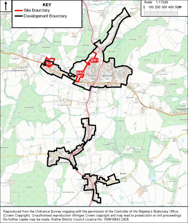
Policy BR1: Land west of A28, Northiam Road Comment
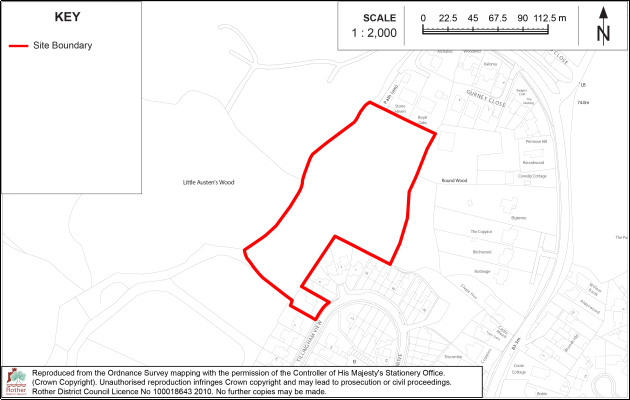
The site is allocated for residential development comprising some 29 new dwellings.
Development on this site must:
i. Provide a policy-compliant amount of on-site affordable housing in line with policy HOU2 of the Rother Local Plan;
ii. Include a new vehicular and pedestrian access via Oakhill Drive to the east;
iii. Provide for a pedestrian and cycle link into the adjoining land to the south which is subject to allocation Policy BR2 of this Plan;
iv. Retain the existing public footpath within the site;
v. Avoid development in the areas shown to be at risk of flooding;
vi. Retain existing trees and hedgerows on the site boundaries and enhance these with additional tree and hedgerow planting employing native species;
vii. Include provision for the retention and future management of a buffer zone of semi-natural habitat, at least 15m wide on the north-western boundary, between the edge of development and the ancient woodland, with semi- natural habitat managed in these areas to maintain a naturalistic character for the users of the footpath;
viii. Provide for an acceptable connection to the local sewerage system.
13.29The site comprises a narrow field at the rear of residential properties fronting the A28 Northiam Road. It is well-related to the village core, providing good access to services, and is relatively well-contained within the landscape.
13.30The site is within the Village Area Type, has a site size of 2.57 hectares and an indicative developable area of 1.53 hectares. It is allocated for some 29 dwellings at an indicative residential density of 30 dwellings per hectare.
13.31It provides direct access to the public right of way network, and an appropriate buffer to adjoining ancient woodland, West Wood, can be achieved. West Wood is also an Area of Particular Importance for Biodiversity (APIB). These are defined and mapped in the East Sussex and Brighton & Hove Local Nature Recovery Strategy (LNRS). Due regard must be taken to the priorities and measures set out within the LNRS.
13.32The site has a medium potential to contain prehistoric, Roman and medieval remains. An archaeological assessment would be a planning application requirement.
Policy BR2: Land west of Tillingham View Comment
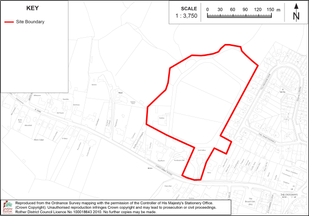
The site is allocated for residential development comprising some 70 new dwellings.
Development on this site must:
i. Provide a policy-compliant amount of on-site affordable housing in line with policy HOU2 of the Rother Local Plan;
ii. Include a new vehicular access from B2089/ Chitcombe Road. This will likely involve the demolition of the Owls Hollow residence;
iii. Include a community use subject to an assessment of needs in the locality;
iv. Include any necessary off-site highway improvements, including improvements to enable active-travel connectivity between the site and the primary school;
v. Provide for a new bus stop, including safe and accessible access, and financial contributions to bus services;
vi. Provide for a pedestrian and cycle link into the adjoining land to the north which is subject to allocation Policy BR1 of this Plan;
vii. Include a significant area of green infrastructure and public open space within the site, including children’s play space;
viii. Include provision for the retention and future management of a buffer zone of semi-natural habitat, at least 15m wide on the north-western boundary, between the edge of development and the ancient woodland, with semi- natural habitat managed in these areas to maintain a naturalistic character for the users of the footpath;
ix. Retain and enhance the existing hedgerows/ trees on each site boundary and include a mixed species native hedgerow to the eastern and southern boundaries to ecologically connect these boundaries towards the northern tree belt and ancient woodland.
13.33 This is a large field on the north-western edge of the village. It is within the Village Area Type, has a site size of 4.5 hectares and an indicative developable area of 2 hectares. It is allocated for some 70 dwellings at an indicative residential density of 35 dwellings per hectare.
13.34While the site does contribute to the rural setting of the village, it has relatively few distinguishing landscape features, and long views are very limited, meaning it is relatively enclosed in the landscape and associated with the settlement. It adjoins substantial 20th century development and is in close proximity to village services including the school, shop and bus stops. Consequently, it provides an opportunity for a relatively large, well-designed residential development and public open space in a sustainable location. The size of the site also provides an opportunity to include a community use, subject to an assessment of needs in the locality.
13.35To ensure the conservation and enhancement of the High Weald National Landscape, trees and hedgerows on site boundaries will need to be retained, and development should be high quality and landscape-led, providing an improved settlement edge. The lower lying land in the north-western part of the site and the minimum 15m buffer from the Little Austen's Wood Ancient Woodland boundary to the north-west will need to be maintained as green infrastructure outside of private ownership, with suitable semi-natural habitat managed in these areas to maintain a naturalistic character for users of the Public Footpath. A belt of green space could extend alongside of the footpath to form a more wooded character to the visual amenity for users of the footpath. A mixed species native hedgerow should be extended adjacent to the existing residential curtilages on the eastern and southern boundaries to better soften and ecologically connect this boundary towards the northern tree belt and ancient woodland.
13.36Adjoining land to the north-east is also allocated for residential development (Policy BR1 of this Plan). The two sites are separated by a substantial tree belt which adjoins ancient woodland, West Wood, and consequently, a vehicular access between the two sites is unlikely to be appropriate, although pedestrian and cycle links will be required to facilitate connectivity. West Wood is also an Area of Particular Importance for Biodiversity (APIB). These are defined and mapped in the East Sussex and Brighton & Hove Local Nature Recovery Strategy (LNRS). Due regard must be taken to the priorities and measures set out within the LNRS.
13.37Access would be from Chitcombe Road and is likely to involve the demolition of an existing dwelling. Off-site highways improvements will be required to encourage active travel between the site and the village facilities, including the nearby primary school, and the policy provides for new public transport infrastructure.
13.38 The site has a medium potential to contain prehistoric, Roman and medieval remains. An archaeological assessment would be a planning application requirement.
Policy BR3: Land at Broad Oak Lodge, Chitcombe Road Comment
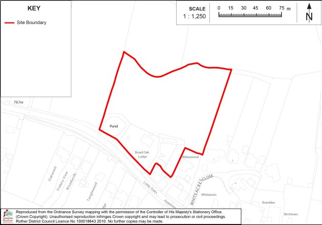
The site is allocated for residential development comprising some 10 new dwellings.
Development on this site must:
i. Provide a policy-compliant amount of on-site affordable housing in line with policy HOU2 of the Rother Local Plan;
ii. Include a new vehicular access from Chitcombe Road;
iii. Include any necessary off-site highway improvements to improve pedestrian and cycle links towards services in Broad Oak including the Primary School;
iv. Provide for bus stop improvements and financial contributions to bus services;
v. Limit development to the southern part of the site (avoiding the existing pond and mature trees);
vi. Include provision for the retention and future management of a buffer zone of semi-natural habitat, at least 15m wide on the northern boundary, between the edge of development and the designated ancient woodland, Redland Wood;
vii. Retain and enhance the existing hedgerow and trees on the site boundaries;
viii. Retain and enhance the existing pond on the southern boundary part of the site and informed by ecological surveys, provide an appropriate buffer to any built development including roadways;
ix. Protect the setting of the Grade II listed building ‘Whiteacres’ to the east of the site.
13.39 The site includes the residential curtilage of a single dwelling together with a field to the rear, at the western end of Broad Oak village. It is within the Village Area Type, has a site size of 1.2 hectares and an indicative developable area of 0.4 hectares. It is allocated for some 10 dwellings at an indicative residential density of 25 dwellings per hectare.
13.40 While development of the entire site would not be acceptable, as it would extend into the countryside, be out of character with the settlement pattern and would impact on an adjacent area of ancient woodland, Redland Wood, extending the existing residential curtilage slightly northwards provides an opportunity to achieve an appropriately designed development in keeping with the character of the adjoining small cul-de-sac development (to the east), while retaining an appropriate separation from the existing pond and mature trees at the front of the site. The location is relatively sustainable, accessible via the existing footway on Chitcombe Road to services further east in Broad Oak, and the policy makes provision for bus stop improvements. Improvements to off-site pedestrian and cycle facilities may also be required.
13.41Environmental constraints include the site being located within the High Weald National Landscape, ancient woodland adjoining the northern boundary, a pond located near the southern boundary and a nearby listed building. Redland Wood is also an Area of Particular Importance for Biodiversity (APIB). These are defined and mapped in the East Sussex and Brighton & Hove Local Nature Recovery Strategy (LNRS). Due regard must be taken to the priorities and measures set out within the LNRS. The policy requirements reflect the constraints.
Camber
Parish: Camber
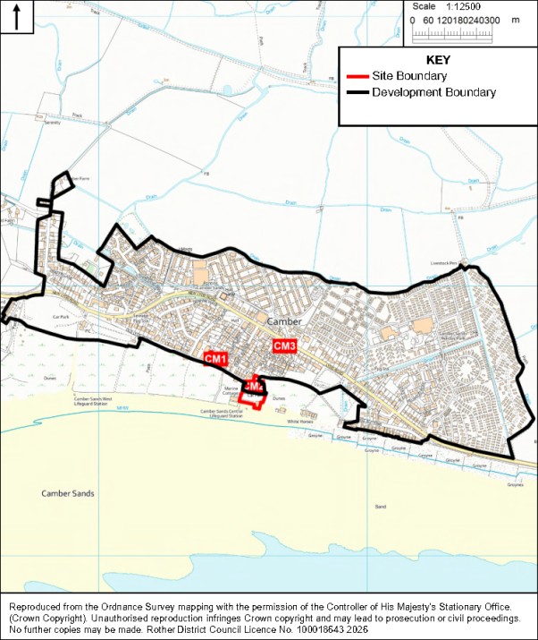
Policy CM1: Land at the Former Putting Green Site, Old Lydd Road, Camber Comment
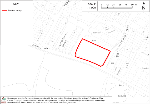
The site is allocated for residential development comprising some 10 new dwellings.
Development on this site must:
i. Provide a policy-compliant amount of on-site affordable housing in line with policy HOU2 of the Rother Local Plan;
ii. Incorporate the recommendations of the Level 2 Strategic Flood Risk Assessment;
iii. Provide a new access from Marchants Drive to the east and/ or the private track to the west;
iv. Provide a new footway alongside the site’s southern boundary to link the new development to the existing Marchants Drive footway;
v. Provide for a new bus stop, including safe and accessible access, and provide financial contributions to bus services;
vi. Ensure no adverse impact on the adjacent Dungeness, Romney Marsh and Rye Bay SSSI;
vii. Ensure the development has no adverse effect on the integrity of the adjacent Dungeness, Romney Marsh, and Rye Bay Special Protection Area and RAMSAR sites and the Dungeness Special Area of Conservation (SAC) in accordance with the Habitats Regulations and Policy ENV8 (Habitats and Species), and the development accords with Policy ENV11 (Sustainable Access and Recreation Management Strategy).
13.42This brownfield site is centrally located in the southern part of the village. It is a raised, rectangular shaped plot of 0.2 hectares, formerly used as a putting green but now cleared and in use as a pay and display car park for 70 cars. It is within the Village Area Type, has a site size of 0.2 hectares. It is allocated for some 10 dwellings at an indicative residential density of 50 dwellings per hectare.
13.43The site is suitable for redevelopment for residential purposes. Built development should be focused on the southern section of the site to avoid overlooking and a reduction in light for the adjacent residential development to the north and west.
13.44The sand dunes opposite the site to the south are significant both as major landscape features and as part of the Dungeness, Romney Marsh & Rye Bay SSSI. The SSSI is also an Area of Particular Importance for Biodiversity (APIB). These are defined and mapped in the East Sussex and Brighton & Hove Local Nature Recovery Strategy (LNRS). Due regard must be taken to the priorities and measures set out within the LNRS. The Dungeness Complex of protected habitats sites is also close to the site. In view of the proximity of the site to the international wildlife designations and the potential for additional impacts, development will be required to ensure that there is no adverse effect on the integrity of the SPA/Ramsar site, in line with the Habitats Regulations and the provisions of Policy ENV11 (Sustainable Access and Recreation Management Strategy (SARMS).
13.45Development will need to incorporate recommendations from the Level 2 Strategic Flood Risk Assessment, as follows:
- Demonstrate through a site-specific FRA that the proposed development will be safe for its lifetime, taking account of the vulnerability of its users.
- Groundwater levels are indicated to be less than 1m below ground level during a 1% AEP event. Detention and attenuation features should be designed to prevent groundwater ingress from impacting hydraulic capacity and structural integrity. Additional site investigation work may be required to support the detailed design of the drainage system. This may include groundwater monitoring to demonstrate that a sufficient unsaturated zone has been provided above the highest occurring groundwater level. Below ground development such as basements are not appropriate at this site.
- Breach modelling should be conducted as part of an FRA to assess the residual risk associated with potential failure of the sea defence south of Old Lydd Road.
- A Flood Response Plan will be required due to surface water flooding predicted along Old Lydd Road during the 1% AEP plus climate change event.
13.46Historically, the site was used as a school and is of local archaeological interest. A heritage statement would be a planning application requirement.
13.47The site’s redevelopment will result in a small reduction in public car parking capacity in the village. However, there is a significant amount of alternative car parking provision in Camber, and the benefits of redeveloping this prominent site, including in terms of it making a valuable contribution to the village’s housing supply and improving the street scene, are considered to outweigh this loss. It is noted that any additional demand for car parking in the winter months could be adequately accommodated elsewhere in the village, including at the Central Car Park, in the event of the redevelopment of the former putting green site. It is not proposed to increase use of the Western Car Park in the winter months (which would raise potential nature conservation issues).
Policy CM2: Land at the Central Car Park, Old Lydd Road, Camber Comment
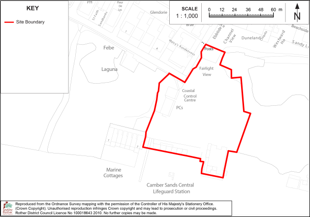
The site is allocated for a comprehensive mixed-use scheme to include an improved public realm with tourism (including visitor accommodation), commercial, car parking and operational uses.
Development on this site must:
i. Include access from Old Lydd Road;
ii. Include a traffic management scheme to manage traffic impacts arising from the development, both during and after the construction period;
iii. Any proposal resulting in a reduction in public car parking space shall include an assessment of the impact on public car parking provision throughout the year and demonstrate that appropriate provision will be retained in the village during the winter period (October to March);
iv. Provide for a new bus stop, including safe and accessible access, and provide financial contributions to bus services;
v. Ensure there is no adverse impact on the integrity of the Dungeness, Romney Marsh and Rye Bay SSSI, SPA, SAC or Ramsar site, including the sand dunes; in accordance with the Habitats Regulations and Policy ENV8 (Habitats and Species), and the development accords with Policy ENV11 (Sustainable Access and Recreation Management Strategy);
vi. Accord with the provisions of Policy ENV6 (Coastal Change Management Area).
vii. Incorporate the recommendations of the Level 2 Strategic Flood Risk Assessment.
13.48This brownfield site, located within Flood Zone 3, is presently the principal car park for this part of the village, open all year round. It is within the Village Area Type and has a site size of 0.6 hectares.
13.49Given its prime position, the redevelopment of the Central Car Park site is an opportunity to act as a catalyst for the regeneration of Camber village by enhancing the tourist offer. A scheme should be brought forward as a comprehensive mixed-use development to include an improved public realm together with tourism, commercial and operational uses (beach patrol office, police/ medical offices) and some car parking. An accessible route to the beach for pedestrians should be retained.
13.50 The new Camber Welcome Centre has recently opened and as such, the allocation has been implemented in part. The remainder of the site remains available for uses such as visitor accommodation and tourism.
13.51The Environment Agency has advised that, whilst much of Camber is protected from flooding to an appropriate standard by the presence of the sand dunes, the car park is not defended and therefore the site is not suitable for permanent residential development. However, holiday accommodation at first floor level, above the design flood level, would be acceptable. An application would need to be accompanied by a site-specific flood risk assessment. The southern part of the site is within the Coastal Change Management Area (and subsequently excluded from the development boundary). This would not preclude appropriate commercial or tourism development, subject to it meeting the requirements of ENV6, including through the submission of a proportionate Coastal Vulnerability Assessment.
13.52The site is immediately adjacent to the Dungeness, Romney Marsh and Rye Bay SSSI to the east, west and south, and also to the Ramsar and SPA to the south. The dunes to the west are also designated as a Local Geological Site. A key factor contributing to dune erosion at Camber is the large numbers of recreational visitors, and effects are worst around the Central Car Park. Consequently, a planning application for the site’s redevelopment will need to include measures to manage access to the dunes adjacent to the site and demonstrate that there will be no adverse effect on the designated areas, including the dunes, from visitors. In view of the proximity of the site to the international wildlife designations and the potential for additional recreational impacts, the development will need to ensure that there is no adverse effect on the integrity of the SPA/Ramsar site. The Dungeness, Romney Marsh and Rye Bay SSSI are also a designated Area of Particular Importance for Biodiversity (APIB). These are defined and mapped in the East Sussex and Brighton & Hove Local Nature Recovery Strategy (LNRS). Due regard must be taken to the priorities and measures set out within the LNRS.
13.53There are underground sewers in the central part of the site, and these will need to be taken into account in planning the site layout.
13.54Development will need to incorporate recommendations from the Level 2 Strategic Flood Risk Assessment, as follows:
- Demonstrate through a site-specific FRA that the proposed development will be safe for its lifetime, taking account of the vulnerability of its users.
- A sequential approach should be undertaken, by locating the most vulnerable aspects of development in areas of lowest flood risk.
- Groundwater levels are indicated to be between 0.5 and 5m below ground level and there is a risk of flooding to subsurface assets and below ground development such as basements. Groundwater monitoring is recommended to determine the seasonal variability of groundwater levels, as this may affect the design of the surface water drainage system.
- Breach modelling should be conducted as part of an FRA to assess the residual risk associated with potential failure of the sea defence south of Old Lydd Road.
- Utilise SuDS with multiple benefits throughout the site, particularly in areas of predicted surface water ponding.
- A Flood Response Plan will be required due to surface water flooding predicted along Old Lydd Road and Sea Road during the 1% AEP plus climate change event.
13.55The site contains World War II defence remains of local archaeological interest. A heritage statement which considers any archaeological impacts, including the preservation of any visible extant remains, will need to accompany the planning application.
13.56In the winter period the site is relied upon as the principal car park in the village, due to part of the large car park at the western end of the village being closed to allow the grass to regrow. In busy summer periods, visitors seeking to access the car park can lead to congestion on Old Lydd Road. Therefore, the traffic implications of the site’s redevelopment, including any reduction in car parking capacity, will need careful consideration including through a traffic management plan.
13.57An opportunity to mitigate any reduction in car parking spaces exists in the “overflow car park” to the north-east of the site. This area, which is accessed through the Central Car Park, is currently only used on the busiest days when the Central Car Park is full. Increased use and formalisation of the overflow car park would require the agreement of the County Council as landowner and should be investigated through a traffic management plan. Another potential traffic management measure to ease congestion is the formation of a one-way through-route from Old Lydd Road to the overflow car park and on to Lydd Road. This would necessitate a new access from Lydd Road to the overflow car park, through the adjacent public open space known as Johnson’s Field, which would require the agreement of the County Council (both as landowner and highway authority) and the Parish Council, which leases the open space. Any such proposals, which could also be considered through a traffic management plan, would also need to assess the implications for open space provision and highway safety, as well as ensuring there is no adverse effect on the adjacent SSSI.
Policy CM3: Lydd Road Garage, Lydd Road, Camber Comment
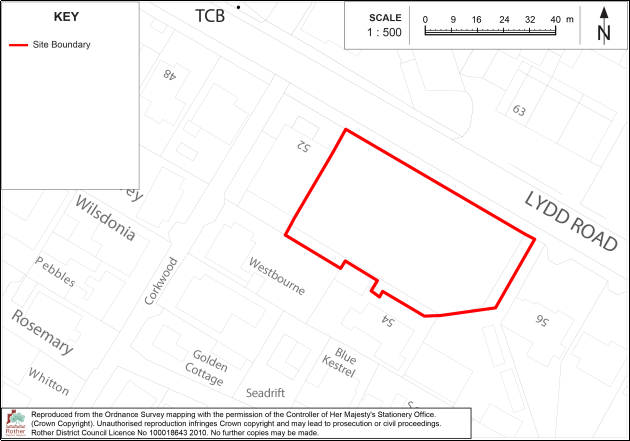
The site is allocated for mixed use development comprisingsome 5 new dwellings and some 80 square metres of new retail floorspace.
Development on this site must:
- Include a new vehicular access from Lydd Road;
- Provide a scheme for the provision of foul and surface water drainage before the commencement of works;
- Provide a remediation strategy and site investigation scheme to deal with the risks associated with the contamination of the site which identifies:
- all previous uses;
- potential contaminants associated with those uses;
- a conceptual model of the site indicating sources, pathways and receptors;
- potentially unacceptable risks arising from contamination at the site.
Development should be carried out in accordance with the findings of the remediation strategy and site investigation scheme;
- Incorporate the recommendations of the Level 2 Strategic Flood Risk Assessment, including a site-specific flood risk assessment, to include details of finished floor levels for non-sleeping accommodation, which must be set no lower than 6.11 meters AOD and finished floor levels for sleeping accommodation are set no lower than 6.41 meters, or as otherwise advised by the Environment Agency.
- Ensure the development has no adverse effect on the integrity of the Dungeness, Romney Marsh, and Rye Bay Special Protection Area and RAMSAR sites and the Dungeness Special Area of Conservation (SAC) in accordance with the Habitats Regulations and Policy ENV8 (Habitats and Species), and the development accords with Policy ENV11 (Sustainable Access and Recreation Management Strategy).
13.58This is a brownfield site located centrally in Camber. It is within the Village Area Type and has a site size of 0.13 hectares. It is allocated for some 5 dwellings and 80sqm retail floorspace at an indicative residential density of 35 dwellings per hectare.
13.59The site was previously occupied by a car repair garage and petrol station and has been vacant for some years. Planning permission was granted in 2015 for a mixed-use development comprising a terrace of 5 dwellings and a commercial unit, but this has not been constructed, although the site remains suitable in principle for development.
13.60However, the site is entirely within Flood Zone 3 and is at risk of surface water flooding and contains contaminated land due to its former use, constraints which will need addressing through the planning application. The policy criteria reflect these constraints. Development will need to incorporate recommendations from the Level 2 Strategic Flood Risk Assessment, as follows:
- Demonstrate through a site-specific FRA that the proposed development will be safe for its lifetime, taking account of the vulnerability of its users.
- Breach modelling should be conducted as part of an FRA to assess the residual risk associated with potential failure of the sea defence south of Old Lydd Road.
- Development will need to be sympathetic to the surface water ponding in the south-western part of the site, potentially taking a sequential approach by locating the most vulnerable aspects of development in areas of lowest flood risk (outside of areas at surface water risk).
- Groundwater levels are indicated to be less than 1m below ground level during a 1% AEP event. Detention and attenuation features should be designed to prevent groundwater ingress from impacting hydraulic capacity and structural integrity. Additional site investigation work may be required to support the detailed design of the drainage system. This may include groundwater monitoring to demonstrate that a sufficient unsaturated zone has been provided above the highest occurring groundwater level. Below ground development such as basements are not appropriate at this site.
- Utilise SuDS with multiple benefits throughout the site, particularly in areas of predicted surface water ponding.
13.61The Dungeness Complex of protected habitats sites is also close to the site. In view of the proximity of the site to the international wildlife designations and the potential for additional impacts, development will be required to ensure that there is no adverse effect on the integrity of the SPA/Ramsar site, in line with the Habitats Regulations and the provisions of Policy ENV11 (Sustainable Access and Recreation Management Strategy (SARMS)).
Iden
Parish: Iden
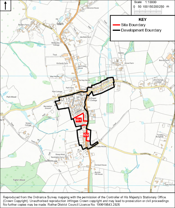
Policy ID1: Land south of Elmsmead, Iden Comment
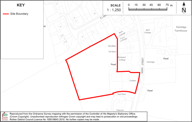
The site is allocated for residentialdevelopment comprising some 15 new dwellings.
Development on this site must:
i. Provide a policy-compliant amount of on-site affordable housing in line with policy HOU2 of the Rother Local Plan;
ii. Include a new vehicular access either from Elmsmead to the north-west or via Main Street to the east;
iii. Provide planting, comprising native species to maintain and reinforce the existing trees/ hedgerows on the site boundaries;
iv. Provide a biodiversity strategy that makes provision for any protected species found to be using the site, and where necessary, includes appropriate mitigation and/ or compensation for any loss of habitat. The strategy shall include the retention and management of the pond and an ecological buffer around the pond;
v. Carry out an assessment and evaluation of the site’s archaeological potential and mitigation measures are implemented;
vi. Respect the amenity of occupiers of adjoining residential properties on the northern and eastern boundaries.
vii. Protect the setting of the Grade II listed buildings adjoining the site.
viii. Include improvements to off-site highway infrastructure including nearby bus stops and financial contributions to other measures to encourage active travel, as required by the Highway Authority.
13.62The site is located on the western side of Main Street. It comprises an undeveloped field associated with residential property, Conkers, a grade II listed building which was formerly a public house, and which is also within the site. It is within the Village Area Type and has a site size of 0.5 hectares. It is allocated for some 15 dwellings at an indicative residential density of 35 dwellings per hectare.
13.63The site adjoins existing development to the north and east and is in close proximity to the village core and all amenities. Conkers is one of several Grade II listed buildings fronting Main Street to the south-east of the site. There are two further Grade II listed buildings, East View and Deacon, adjacent to the site to the south and also Rose Cottage to the northeast.
13.64The site is largely laid to rough grass with scattered self-seeded trees. Taller trees and scrub define the eastern and western boundaries. Existing trees on the eastern and western boundaries will need to be retained and enhanced. A small pond is located in the south-eastern corner of the site. The pond, together with adjoining trees and the field south of the site, has the potential to support biodiversity, including protected species. A short distance to the southwest an area of traditional orchard is also an Area of Particular Importance for Biodiversity (APIB). These are defined and mapped in the East Sussex and Brighton & Hove Local Nature Recovery Strategy (LNRS). Due regard must be taken to the priorities and measures set out within the LNRS.
Policy ID2: Land at Street Field, Main Street, Iden Comment
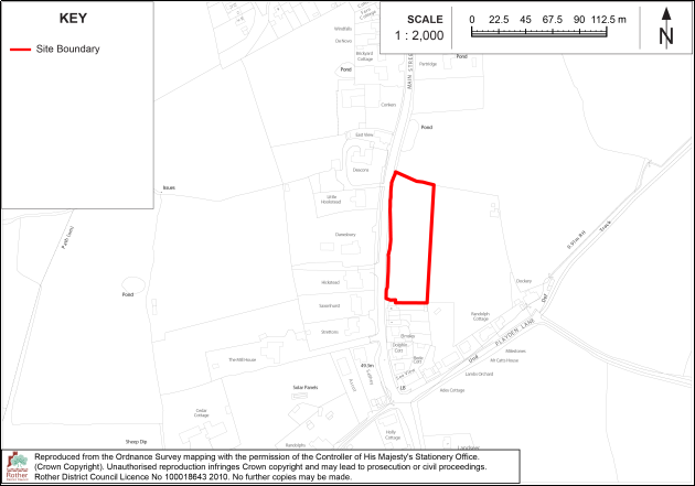
The site is allocated for residentialdevelopment comprising some 10 new dwellings.
Development on this site must:
i. Provide a policy-compliant amount of on-site affordable housing in line with policy HOU2 of the Rother Local Plan;
ii. Include a new vehicular access from Main Street;
iii. Restrict development to a linear layout of small, terraced houses along Main Street;
iv. Retain and enhance the existing hedgerow on the western boundary with Main Street, except for a short section to be removed to facilitate an access point and sight lines, which should be minimised as far as possible;
v. Protect the setting of the Grade II listed buildings opposite and to the north and south of the site and retain and enhance the on-site historic field boundary;
vi. Provide improvements to off-site highway infrastructure to encourage active travel and for pedestrian safety, including new pedestrian footway, improvements to nearby bus stops and pedestrian access to bus stops, and financial contributions to other measures to encourage active travel, as required by the Highway Authority;
vii. Include an assessment and evaluation of the site’s archaeological potential and the implementation of any mitigation measures identified through the assessment;
viii. Be laid out to ensure future access to existing sewerage infrastructure for maintenance and upsizing purposes.
13.65The site forms the western section of a gently sloping open field at the southern end of the village, forming part of a wider fieldscape which extends into open countryside to the east. It is within the Village Area Type and has a site size of 0.35 hectares. It is allocated for some 10 dwellings at an indicative residential density of 35 dwellings per hectare.
13.66The site is bordered by a short terrace of cottages, including grade II listed buildings, on its southern boundary. It has a substantial roadside hedge on its boundary with Main Street and a field access. It is important that development is subordinate to the listed building group to preserve their setting, and that the historic roadside hedge and open fieldscape to the east is retained to protect the rural character of Iden’s southern approach.
13.67The site is suitable for a short terrace of small houses fronting Main Street, which would continue the adjoining ribbon development northwards. Development must be of an appropriate high-quality design in order to respect the rural setting of the village within the High Weald National Landscape, the setting of adjacent listed buildings and the presence of an archaeological notification area. The proposal should demonstrate how the linear settlement form, roadside hedge, listed-building group, local materials and rural village edge have informed the layout, grain, scale and appearance. Replacement native planting, soft verge treatment and restrained surfacing should be used to preserve the rural street character.
Northiam
Parish: Northiam
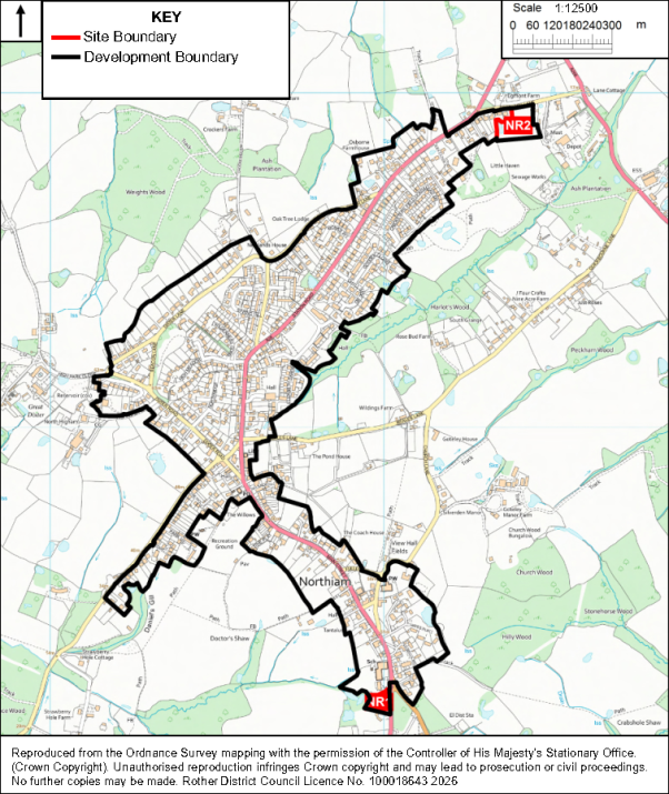
Policy NR1: Land south of Northiam Church of England Primary School, Northiam Comment
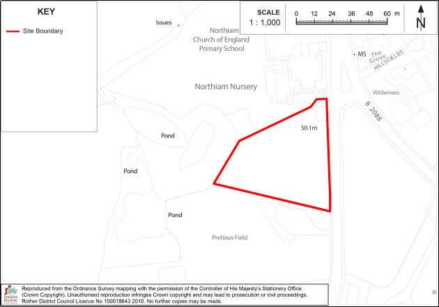
The site is allocated for residentialdevelopment comprising some 7 new dwellings.
Development on this site must:
i. Provide a policy-compliant amount of on-site affordable housing in line with policy HOU2 of the Rother Local Plan
ii. Include vehicle access to the A28 to the satisfaction of the Highway Authority;
iii. Retain existing trees on the eastern and western boundaries, protected by Tree Preservation Orders, and retain and enhance the hedgerow on the eastern boundary with native species; and
iv. Include an assessment and evaluation of the site’s archaeological potential and the implementation of any mitigation measures identified through the assessment.
13.68The site is on the southern fringe of the village on the western side of the A28. It comprises an undeveloped area of land between the Primary School and Nursery (to the north) and a detached residential property (to the south). It is within the Village Area Type and has a site size of 0.34 hectares and an indicative developable area of 0.2 hectares. It is allocated for some 7 dwellings at an indicative residential density of 35 dwellings per hectare.
13.69The land slopes down away from the road and is mostly laid to grass. There are two mature Oak trees and a Pine tree on the frontage of the site and two mature Oak trees at the rear of the site, all of which are protected by Tree Preservation Orders. A comprehensive tree survey will need to inform any future development scheme to ensure the retention of the protected trees, including the provision of a suitable buffer to protect their roots, and to avoid undue overshadowing from the trees in planning the site layout. The opportunity should also be taken to enhance the existing hedgerow on the front boundary of the site. To the west, an area of priority habitat is also an Area of Particular Importance for Biodiversity (APIB). These are defined and mapped in the East Sussex and Brighton & Hove Local Nature Recovery Strategy (LNRS). Due regard must be taken to the priorities and measures set out within the LNRS.
13.70While the site is not at significant risk of flooding, the Rother Strategic Flood Risk Assessment identifies Quickbourne Lane, Ewhurst Lane and Station Road in Northiam as areas that could become at increased risk from surface water flooding in the future, due to increased rainfall intensities as a result of climate change. Therefore, it will be important that the sustainable drainage (SuDS) measures included in the development proposal addresses and mitigates potential effects on land outside the site, the need for SuDS features could affect the site layout.
13.71A single access point onto the A28 should be provided. This is likely to be achieved towards the northern end of the site’s eastern boundary and must not harm protected trees on the site boundary. Access from the A28 to the adjacent school playing field must be retained. Given the close proximity of the site to the school and the junction with the B2088, a safety audit will need to be carried out as part of the planning application and suitable sight lines achieved, to the satisfaction of the Highway Authority.
13.72A scheme for the site’s development will need to be of a high design quality, appropriate to its location within the High Weald AONB and adjacent to the Northiam Conservation Area.
13.73 The site has high potential for prehistoric, Roman and medieval archaeological remains and an archaeological assessment will need to be undertaken as part of the planning application for its future development, the results of which may need to inform the site layout.
13.74A sewer line passes close to the northern boundary of the site, and this will also need to be considered in planning a development layout.
Policy NR2: Land south of Coppards Lane, Northiam Comment
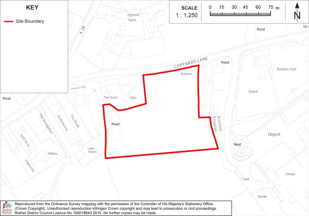
The site is allocated for residentialdevelopment comprising some 15 new dwellings.
Development on this site must:
i. Provide a policy-compliant amount of on-site affordable housing in line with policy HOU2 of the Rother Local Plan;
ii. Be informed by an odour assessment to take account of potential impacts arising from the wastewater treatment works to the south of the site;
iii. Be informed by a noise assessment to take account of potential impacts arising from the industrial area to the east of the site;
iv. Include a new vehicular access from Coppards Lane;
v. Include new pedestrian and cycle links to Station Road and any other off-site improvements to highway infrastructure identified by the Highway Authority as necessary to improve access to the site by active travel and public transport;
vi. Include provision for the retention and future management of a buffer zone of semi-natural habitat on the eastern boundary, between the edge of development and the adjacent woodland;
vii. Retain and protect the existing trees and hedgerows on the site boundaries, excepting for any short section of the northern boundary required to be removed to facilitate safe access, which should be minimised as far as possible;
viii. Include a new boundary hedgerow to define the southern boundary of the site;
ix. Retain and enhance the existing pond in the western part of the site and provide an appropriate buffer to any built development including roadways, as informed by an ecological survey, to be completed;
x. Ensure future access to existing sewerage infrastructure for maintenance and upsizing purposes.
13.75The site comprises the northern part of a field, fronting Coppards Lane. It is located between dwellings, just west of the Coppards Lane industrial area. It is within the Village Area Type, has a site size of 0.9 hectares and an indicative developable area of 0.6 hectares. It could accommodate some 15 dwellings at an indicative density of 25 dwellings per hectare.
13.76The location of the site within the High Weald National Landscape contributes to the rural setting therefore, a sensitive form of development, including significant areas of green infrastructure, and the retention and enhancement of High Weald features including hedgerows and mature trees, is required in line with Local Plan policies.
13.77The site will need to be carefully laid out, informed by an odour impact assessment (to account for potential effects from the wastewater treatment works to the south) and a noise impact assessment (to account for potential effects from business activities to the east); also, to ensure necessary easements and access for the underground sewerage infrastructure in the eastern part of the site; and to accommodate necessary sustainable drainage measures.
13.78While the site is not at significant risk of flooding, the Rother Strategic Flood Risk Assessment identifies Quickbourne Lane, Ewhurst Lane and Station Road in Northiam as areas that could become at increased risk from surface water flooding in the future, due to increased rainfall intensities as a result of climate change. Therefore, it will be important that sustainable drainage measures address and mitigate any potential effects.
13.79 The site is some distance from services in the main village however, bus stops are located a short distance away on Station Road. Policy requirements include necessary improvements to pedestrian and cycle infrastructure to connect the site to Station Road and the village core; these will need to be sensitively designed to take into account the rural character of Coppards Lane in line with the HWNL Management Plan.
13.80Environmental constraints include wooded boundaries, linking to ancient woodland beyond the southern boundary, a pond located near the western boundary and a historic field boundary to the site. The above policy requirements reflect the constraints. To the west an area of woodland is also an Area of Particular Importance for Biodiversity (APIB). These are defined and mapped in the East Sussex and Brighton & Hove Local Nature Recovery Strategy (LNRS). Due regard must be taken to the priorities and measures set out within the LNRS.
Peasmarsh
Parish: Peasmarsh
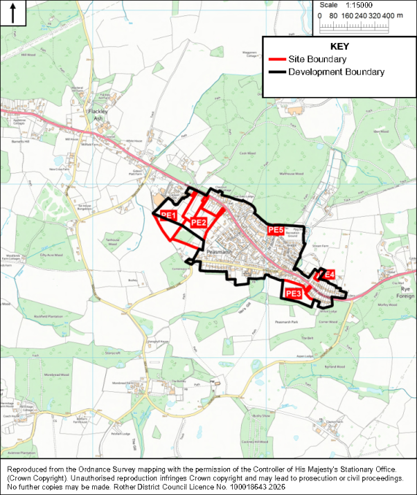
Policy PE1: Land south of Main Street, Peasmarsh Comment
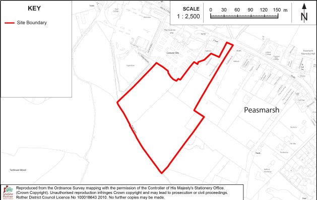
The site is allocated for residentialdevelopment comprising some 55 new dwellings.
Development on this site must:
i. Provide a policy-compliant amount of on-site affordable housing in line with policy HOU2 of the Rother Local Plan
ii. Provide vehicular, pedestrian and cycle access from Main Street (which is likely to require demolition of a dwelling);
iii. Include improvements to off-site highway infrastructure including: a new pedestrian crossing on Main Street, a new bus stop on the westbound side of Main Street, improvements to the existing eastbound bus stop, and financial contributions towards bus services, all in accordance with the requirements of the Highway Authority;
iv. Include new pedestrian links to Jempsons and south-eastwards towards School Lane, integrating (and diverting as necessary) the existing public right of way and including any necessary improvements, to the satisfaction of the Rights of Way Officer;
v. Provide for new pedestrian and cycle links to the adjoining allocated site to the south-east (“Land at Pippins, Main Street”);
vi. Retain and enhance the existing hedgerows/ trees on the boundaries of the site and within the site, and include a landscaped buffer area of Green Infrastructure in the southern part of the site and along the south-western boundary, which could also include sustainable drainage, public open space, play space and new tree planting to screen the site in views from the south-west and protect and enhance the adjoining area of Priority Habitat (traditional orchard) to the south-east.
13.81The site comprises a series of paddocks and a horse menage, at the rear of ribbon development fronting Main Street. It is within the Village Area Type, has a site size of 3.1 hectares and an indicative developable area of 1.8 hectares. It could accommodate some 55 dwellings at an indicative density of 30 dwellings per hectare.
13.82 The site is relatively level and enclosed from views from the wider countryside. On its south-eastern boundary the site adjoins land allocated for housing and open space through Policy PE2 of this Plan. The site is suitable for residential development, subject to improvements to encourage active travel, protection of trees and hedges, and the provision of an appropriate landscape- and open space- buffer on its southern section to screen long views to the south and to tie in with the open space provision in the allocated site to the east.
13.83While the site is not at significant risk of flooding, the Rother Strategic Flood Risk Assessment identifies Main Street, School Lane and Farleys Way in Peasmarsh as areas that could become at increased risk from surface water flooding in the future, due to increased rainfall intensities as a result of climate change. Therefore, it will be important that the sustainable drainage measures included in the development proposal, address and mitigate any potential effects on land outside the site.
13.84 The site is within the High Weald National Landscape and therefore a sensitive form of development is required in line with Local Plan policies. Environmental constraints including Traditional Orchard Priority Habitat (protected by a Tree Preservation Order) adjacent to the eastern boundary. This area is also an Area of Particular Importance for Biodiversity (APIB). These are defined and mapped in the East Sussex and Brighton & Hove Local Nature Recovery Strategy (LNRS). Due regard must be taken to the priorities and measures set out within the LNRS.
13.85The site is partly within an Archaeological Notification Area; an archaeological assessment will be a requirement at planning application stage. It also contains a Historic Field Boundary and Public Right of Way, and the policy requirements reflect these constraints.
13.86 The site is close to existing services and facilities in Peasmarsh, and improvements to off-site highway infrastructure (including bus stops) and pedestrian and cycle linkages are required through the policy to encourage active travel.
13.87 It is acknowledged that this site, together with the adjoining allocated site (Policy PE2) will result in a large residential development on the edge of the village and within the National Landscape. This can be justified in this location, given the close proximity of services and facilities and also the need for housing, although improvements to bus stops and a contribution towards bus services will be required. In landscape terms both sites are well-related to the built form of the village, and enhancements to High Weald features including boundary trees and hedgerows and historic field boundaries can be secured.
Policy PE2: Land rear of Pippins, Main Street, Peasmarsh Comment
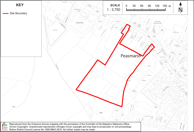
The site is allocated for residentialdevelopment comprising some 45 new dwellings.
Development on this site must:
i. Provide a policy-compliant amount of on-site affordable housing in line with policy HOU2 of the Rother Local Plan
ii. Include a vehicular access from Main Street to the satisfaction of the Highway Authority;
iii. Include additional pedestrian access to the north-east of the site, connecting down the length of the eastern boundary via a green corridor; and southwards connecting to the footpath network;
iv. Provide for a new bus stop, including safe and accessible access, and provide financial contributions to bus services.
v. Provide a children’s play area, which should be subject to passive surveillance from residential frontages, with funding and management arrangements secured for its ongoing maintenance;
vi. Provide open space in the southern part of the site, incorporating the traditional orchard within it, with funding and management arrangements secured for its on-going maintenance;
vii. Retain and enhance the other existing ecological and High Weald NL character features as far as reasonably practicable, including historic field boundaries, boundary hedgerows, existing trees and existing pond;
viii. Maintain and reinforce the existing landscaped boundaries around the site with native planting and create new landscaped boundaries on exposed western edges.
13.88The site comprises fields, paddocks and a traditional orchard at the rear of residential properties on Main Street. It is within the Village Area Type, has a site size of 3.2 hectares and an indicative developable area of 1.3 hectares. It could accommodate some 45 dwellings at an indicative density of 35 dwellings per hectare.
13.89Access will be from Main Street via land currently occupied by “Pippins”, a detached residential property which would be demolished. A priority solution for traffic will be required on a narrow section of the access road, some 70m into the site. A Road Safety Audit will be required to inform the precise details of the access, to be determined at planning application stage.
13.90New pedestrian routes should traverse the site, linking it to Main Street to the north and the public footpath network to the south and west. The existing track off Main Street, identified for this purpose, may require some upgrading. This would be for further consideration at planning application stage.
13.91Residential development will be limited to the northern and central parts of the site as these areas are well screened from the wider countryside. The southern section has a rising topography and a more rural character and is suited to use as public open space. A children’s play area should be provided in the south-eastern part of the site.
13.92The traditional orchard, which is both a Priority Habitat and a character feature of the High Weald National Landscape, is to be retained, together with other existing ecological and National Landscape character features. These include historic field boundaries on the southern edges of the site, boundary hedgerows, mature trees (including a large oak tree on the western side of the site) and ponds. The orchard is also an Area of Particular Importance for Biodiversity (APIB). These are defined and mapped in the East Sussex and Brighton & Hove Local Nature Recovery Strategy (LNRS). Due regard must be taken to the priorities and measures set out within the LNRS.
13.93 Additional hedgerows of native species would assist in screening the residential development and offer the opportunity for biodiversity enhancement. Future maintenance and management of these elements will need to be secured through a planning permission.
13.94Surface water flow paths cross the southern part of the site and SuDS will to be required. While the site is not at significant risk of flooding, the Rother Strategic Flood Risk Assessment identifies Main Street, School Lane and Farleys Way in Peasmarsh as areas that could become at increased risk from surface water flooding in the future, due to increased rainfall intensities as a result of climate change. Therefore, it will be important that the sustainable drainage measures included in the development proposal address and mitigates any potential effects on land outside the site.
13.95The site has high potential for prehistoric, Roman and medieval archaeological remains. Appropriate archaeological assessment will need to be undertaken in support of a planning application for its future development.
Policy PE3: Tanyard, Main Street, Peasmarsh Comment
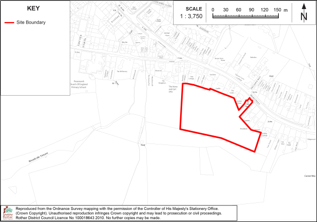
The site is allocated for residentialdevelopment comprising some 15 new dwellings.
Development on this site must:
i. Provide for a wholly or substantially affordable housing scheme;
ii. Include a new vehicular access from Main Street and any necessary off-site highway infrastructure improvements as required by the Highway Authority;
iii. Provide a pedestrian link to the adjacent Public Right of Way leading from School Lane;
iv. Provide for bus stop improvements and financial contributions to bus services;
v. Retain and enhance the existing hedgerow and trees on the southern and eastern boundaries of the site and within the site and provide an area of Green Infrastructure and land for Biodiversity Net Gain in the southern part of the site;
vi. Protect the setting of the two Grade II listed buildings, Stream Farm Cottage and Stream Farmhouse to the north of the site access;
vii. Protect and enhance the Deciduous Woodland Priority Habitat to the south of the site;
viii. Protect the residential amenity of the occupiers of adjoining dwellings.
13.96The site comprises a section of a field, south and to the rear of linear development on Main Street and School Lane. It is within the Village Area Type, has a site size of 1.8 hectares and an indicative developable area of 0.5 hectares. It could accommodate some 15 dwellings at an indicative density of 35 dwellings per hectare.
13.97The site is within the High Weald National Landscape. It slopes up from the edge of the village and is visible from public and private viewpoints. Development in the southern part of the site (on the highest ground) would be prominent in views and would not relate well to the established linear settlement pattern. It should remain as green infrastructure and open space where this is necessary to contain the development, protect views, conserve the wooded High Weald edge and maintain a softer transition from the village into countryside. The woodland to the south is also an Area of Particular Importance for Biodiversity (APIB). These are defined and mapped in the East Sussex and Brighton & Hove Local Nature Recovery Strategy (LNRS). Due regard must be taken to the priorities and measures set out within the LNRS.
13.98 A small residential development could be accommodated in the northern and eastern parts of the site, with an area of green infrastructure to the south which would also provide a buffer to the adjoining woodland (priority habitat). The landowner has indicated that the site is available for an affordable housing scheme of 15 dwellings.
13.99Access from Main Street and any off-site highway improvements should be sensitively designed where they affect the setting of the listed buildings or the character of Main Street. The access should not urbanise the setting of the listed buildings or create a conspicuous engineered break in the Main Street frontage. Pedestrian links to the public right of way from School Lane should be integrated with the landscape framework and should help maintain permeability without fragmenting hedgerows, trees or the southern green infrastructure.
13.100 The heritage context includes the Grade II listed Stream Farmhouse and Stream Farm Cottage to the north of the site access. Layout, access, density and landscape structure of new development must be particularly carefully controlled to avoid affecting the setting of the listed buildings by introducing a more inward-looking or estate-like form of development to their rear. Built form should be modest in scale, clearly subservient to the historic Main Street frontage, and arranged so that it reads as a limited village-edge intervention rather than a new depth of settlement extending up the slope. The layout should be informed by Historic England’s ‘The Setting of Heritage Assets’- Historic Environment Good Practice Advice in Planning Note 3 (Second Edition). The site is also partly located within an Archaeological Notification Area.
13.101While the site is not at significant risk of flooding, the Rother Strategic Flood Risk Assessment identifies Main Street, School Lane and Farleys Way in Peasmarsh as areas that could become at increased risk from surface water flooding in the future, due to increased rainfall intensities as a result of climate change. Therefore, it will be important that the sustainable drainage measures included in the development proposal address and mitigate these potential effects on land outside the site.
13.102The site is well located in relation to village services but improvements to public transport infrastructure may be required in line with the recommendations of the Highway Authority.
Policy PE4: Land East of Orchard Way Comment
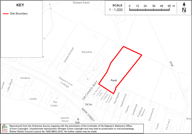
The site is allocated for residentialdevelopment comprising some 5 new dwellings.
Development on this site must:
i. Include a new vehicular access from Main Street.
ii. Include no built development in the southern part of the site which is shown to be at risk of surface water flooding.
iii. Retain and enhance the existing hedgerow and trees on the western boundary of the site.
iv. Retain and enhance the existing pond in the south-eastern part of the site and provide an appropriate buffer to any built development including roadways, as informed by an ecological survey, to be completed.
v. Incorporate the recommendations of the Level 2 SFRA.
vi. Include sustainable drainage in the southern section of the site in accordance with Policy ENV2 of the Rother Local Plan.
vii. Protect the setting of the Grade II listed buildings, Stream Farmhouse and Stream Cottage, to the southwest of the site.
13.103 The site is located at the end of a short lane, behind houses on Main Street. It is within the Village Area Type and has a site area of 0.2 hectares. It could accommodate some 5 dwellings at an indicative density of 35 dwellings per hectare.
13.104The policy carries forward an allocation from the Peasmarsh Neighbourhood Development Plan.
13.105The site is within the High Weald National Landscape and therefore a sensitive form of development is required in line with Local Plan policies. Environmental and other constraints affecting the site include two listed buildings located to the west of the site. Surface water flooding is a risk in the southern half of the site and there is a pond located in the southeast corner. The site is located partly within an Archaeological Notification Area. The layout should be informed by Historic England’s ‘The Setting of Heritage Assets’- Historic Environment Good Practice Advice in Planning Note 3 (Second Edition).’
13.106Development will need to incorporate recommendations from the Level 2 Strategic Flood Risk Assessment, as follows:
- Development will need to be sympathetic to the surface water ponding in the south of the site, potentially taking a sequential approach by locating the most vulnerable aspects of development in areas of lowest flood risk. May require consideration of land raising and flood storage. Detailed surface water modelling will be required to assess the flood risk, and mitigation approach should ground modifications be carried out in areas of flood risk.
- Demonstrate through a site-specific FRA that the proposed development will be safe for its lifetime, taking account of the vulnerability of its users.
- Utilise SuDS with multiple benefits throughout the site, particularly in areas of predicted surface water ponding.
- A Flood Response Plan will also be required due to significant surface water flooding predicted along Orchard Way.
Policy PE5: Land at Malthouse Business Park, The Maltings, Peasmarsh Comment
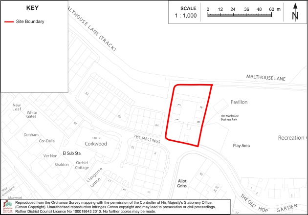
The site is allocated for mixed use development comprising some:
- 6 new dwellings; and
- 400 sqm of business floorspace Use Class E(g).
Development on this site must:
- Provide a policy-compliant amount of on-site affordable housing in line with policy HOU2 of the Rother Local Plan;
- Comprise of smaller dwellings of one- and two-bedroom flats;
- Reuse the vehicular access from The Maltings/The Old Hop Garden;
- Provide for any off-site highway works and/or financial contributions to bus services as required by the Highway Authority;
- Include provision for the retention and future management of a buffer zone of semi-natural habitat on the northern boundary, between the edge of development and the adjacent Deciduous Woodland Priority Habitat (and ancient woodland further north);
- Be designed to protect the amenity of the neighbouring residential properties.
13.107The site comprises a small business park containing six single-storey business units and an associated parking and turning area. It is within the Village Area Type and has a site area of 0.18 hectares. It provides for a redevelopment opportunity by retaining the quantum of existing business floorspace and allowing for a mixed-use development with smaller flats on the upper storeys, at an indicative residential density of 35 dwellings per hectare.
13.108The site is within a largely residential area adjacent to the village recreation ground, children's play area and pavilion.
13.109The site is within the High Weald National Landscape and therefore a sensitive form of development is required in line with Local Plan policies. Environmental and other constraints affecting the site include an area of Deciduous Woodland Priority Habitat, Malthouse Wood, adjacent to the northern boundary, and an area of ancient woodland slightly further north. The woodland is also an Area of Particular Importance for Biodiversity (APIB) as defined and mapped in the East Sussex and Brighton & Hove Local Nature Recovery Strategy (LNRS). Due regard must be had to the priorities and measures set out within the LNRS.
Playden
Parish: Playden
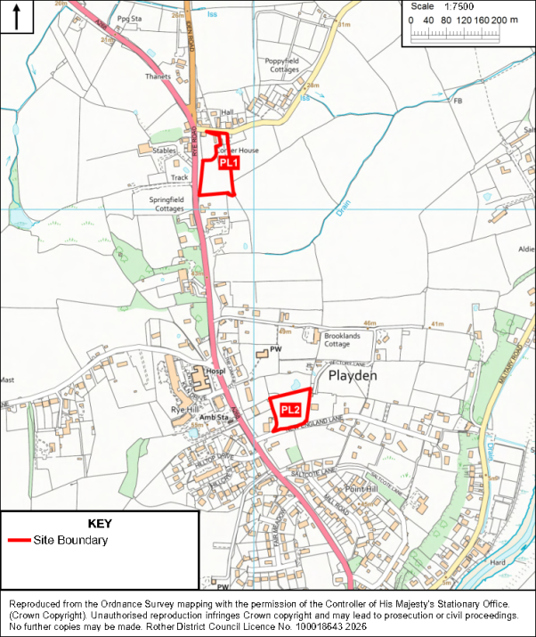
Policy PL1: Land South of Corner House, Rye Road, Playden Comment
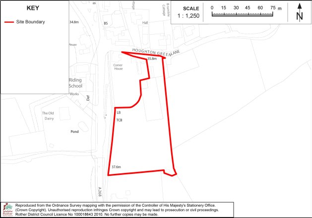
The site is allocated for residential development comprising some 15 new dwellings.
Development on this site must:
i. Provide a policy-compliant amount of on-site affordable housing in line with policy HOU2 of the Rother Local Plan;
ii. Include a new vehicular access from Houghton Green Lane, which minimises removal of the northern boundary hedgerow and preserves the semi-rural character of the lane, also including infrastructure allowing pedestrians to step off the carriageway, and access for pedestrians and cyclists;
iii. Include off-site improvements to Houghton Green Lane between the site and the primary school, informed by highway survey work, to include pedestrian refuges along the lane;
iv. Provide an active travel route through the site between Houghton Green Lane and Rye Road and a pedestrian access onto the Rye Road (the A268), minimising loss of trees/ hedgerows on this western boundary;
v. Be informed by a tree survey in accordance with Policy LAN3 to ensure the retention and protection of existing trees and hedgerows on the site boundaries. The trees should not be included within the curtilage of new residential houses, but remain in public space with a long-term management strategy;
vi. Include an area of green infrastructure in the western and southern parts of the site, which also facilitates the retention and protection of the mature trees on these boundaries;
vii. Protect the setting of the Grade II listed building, Playden Oasts Hotel, to the south of the site.
13.110 The site comprises garden land and part of a field associated with “Corner House”. It is located between Houghton Green Lane (to the north) and Rye Road (the A268) (to the west). It is within the Village Area Type, has a site size of 0.67 hectares and an indicative developable area of 0.4 hectares. It could accommodate some 15 dwellings at an indicative density of 37 dwellings per hectare.
13.111The site is relatively level and enclosed from longer views and it lies outside the High Weald National Landscape, which is on the opposite side of the road to the west. The tall, mature line of trees on the western (roadside) boundary of the site is a prominent feature in the local landscape and must be retained and protected. Vehicular access should only come from Houghton Green Lane to the north, but a pedestrian route through the site, between the Lane and Rye Road, can be accommodated while retaining the trees, and must be provided to allow a safe pedestrian route from the site to Rye Road.
13.112A sensitive design will be necessary to ensure the setting of the Playden Oasts Hotel, a grade II listed building to the south, is protected. The setting of the listed building includes not only its immediate curtilage, but also the adjoining open land, mature trees, roadside boundary, and the degree to which the oasts remain legible as a former agricultural building group rather than being visually absorbed into surrounding suburban development. The green infrastructure requirement set out in the policy will ensure the protection and retention of the roadside trees and also provide an appropriate landscape buffer between the new development, Rye Road and the listed oasthouse buildings. The site layout should be informed by Historic England’s ‘The Setting of Heritage Assets’- Historic Environment Good Practice Advice in Planning Note 3 (Second Edition).
13.113In terms of accessibility, the site is at the northern end of the village but within walking distance of bus stops and some services. The improvements to active travel infrastructure, including a route through the site, will ensure opportunities for active travel are realised.
Policy PL2: Land between Saltcote and The Steps, New England Lane, Playden Comment
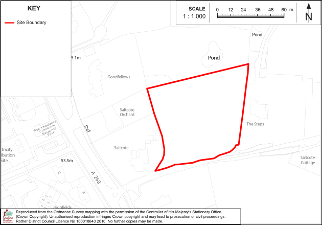
The site is allocated for residential development comprising some 10 new dwellings.
Development on this site must:
i. Provide a policy-compliant amount of on-site affordable housing in line with policy HOU2 of the Rother Local Plan;
ii. Include a new vehicular access from New England Lane in the south-western corner of the site;
iii. Be of an appropriate layout, form and detailed design to ensure the protection of the setting of the Grade I Listed building “The Parish Church of St Michael” to the north of the site;
iv. Include off-site highway improvements to include a new pedestrian footway alongside New England Lane to link the site to the existing footway alongside the A268, Rye Road;
v. Include no built development close to the southern boundary in order to ensure the protection of mature trees on this boundary and to avoid the area which is shown to be at risk of surface water flooding;
vi. Retain and enhance the existing hedgerows and trees on the boundaries of the site.
13.114The site is a small field on the northern side of New England Lane, close to services in Playden and bus stops on Rye Road. It is within the Village Area Type, has a site size of 0.6 hectares and an indicative developable area of 0.3 hectares. It could accommodate some 10 dwellings at an indicative density of 30 dwellings per hectare.
13.115The site is generally well enclosed by adjoining development and trees and lies outside the High Weald National Landscape. However, it has heritage sensitivities, being partly within an Archaeological Notification Area and close to a Grade I listed building, The Parish Church of St Michael, which lies to the northwest. The detailed design will need to be informed by heritage and landscape assessments to ensure the setting of the listed building remains protected. Development should be of a restrained domestic scale with a carefully designed roofscape and materials that respond to Playden’s rural and historic context. The layout should be informed by Historic England’s ‘The Setting of Heritage Assets’- Historic Environment Good Practice Advice in Planning Note 3 (Second Edition). The need for sensitive design also extends to the necessary highway works outside the site.
13.116Access is from the narrow New England Lane only, and consequently, an appropriate vehicular access point would need to be at the south-western corner before the Lane narrows significantly and the levels change. The pedestrian footway will also need to be extended to reach the site. The access and any off-site footway extension should be carefully designed so as not to introduce an over-engineered suburban edge to a narrow village lane. Junction geometry, surfacing, signage, lighting and boundary treatment should be kept restrained and locally responsive. The footway link to the existing footway on Rye Road should improve pedestrian safety without unnecessarily eroding the rural character of New England Lane.
13.117A pond is located outside the site to the north, and the southern boundary has a risk of surface water flooding in the centre. The existing tree boundary to the north and east partly screen the site from the wider countryside. The existing trees on the roadside (southern) boundary are large and significant features in the local landscape and should be retained in the site layout. Development should be kept away from the southern part of the site to protect the trees and avoid the areas at risk of flooding. A short distance to the northwest an area of greenspace is also an Area of Particular Importance for Biodiversity (APIB), as defined and mapped in the East Sussex and Brighton & Hove Local Nature Recovery Strategy (LNRS). Due regard must be taken to the priorities and measures set out within the LNRS.
Rye Harbour
Parish: Icklesham
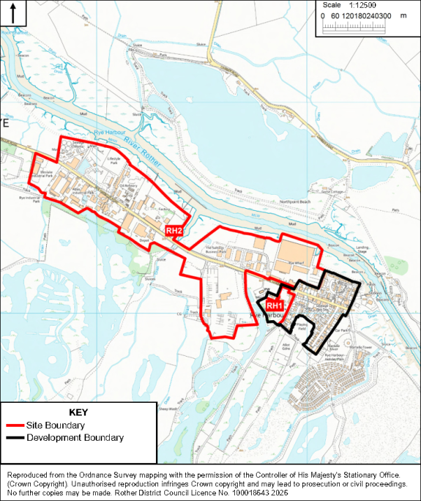
Policy RH1: Land at Stoneworks Cottages, Harbour Road, Rye Harbour Comment
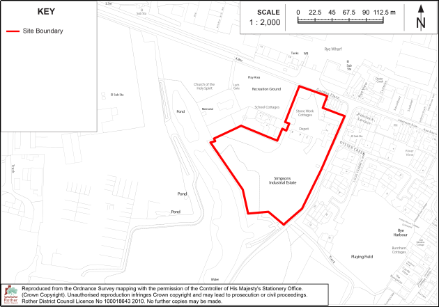
The site is allocated for residential development comprising some 40 new dwellings.
Development on this site must:
i. Provide a policy-compliant amount of on-site affordable housing in line with policy HOU2 of the Rother Local Plan;
ii. Provide a new access from Harbour Road;
iii. Retain and enhance the tree belt on the south-western boundary with native species, with appropriate fencing erected to maintain an effective barrier between the site and the adjacent Dungeness, Romney Marsh and Rye Bay SSSI, SPA and Ramsar Site;
iv. Retain and enhance a screen of tree and hedgerow planting, employing native species provided on other boundaries of the site;
v. Ensure ecological surveys are carried out which demonstrate that there is no adverse impact on protected species or, if any protected species are found to be using the site, sets out appropriate mitigation for any loss of habitat;
vi. Incorporate the recommendations of the Level 2 Strategic Flood Risk Assessment;
vii. Demonstrate that the development will be safe for its lifetime, taking account of the vulnerability of its users, without increasing flood risk elsewhere, and where possible, will reduce flood risk overall;
viii. Ensure a ground contamination assessment has been undertaken which demonstrates that pollution risks, including to the underlying aquifer, will be managed appropriately through the re-development process; and
ix. Ensure the development has no adverse effect on the integrity of the Dungeness, Romney Marsh, and Rye Bay SSSI, Special Protection Area and RAMSAR sites and the Dungeness Special Area of Conservation (SAC), in accordance with the Habitats Regulations and Policy ENV8 (Habitats and Species), and the development accords with Policy ENV11 (Sustainable Access and Recreation Management Strategy).
13.118 The site is on the southern side of Harbour Road, to the west of existing residential development. It is within the Village Area Type and has a site size of 1.6 hectares and an indicative developable area of 1 hectare. It could accommodate some 40 dwellings at an indicative residential density of 40 dwellings per hectare.
13.119The site comprises brownfield land currently in low-key employment use. The policy carries forward an allocation from the previous Local Plan.
13.120The site lies within Flood Zone 3, contains small areas of surface water flooding and has high underlying groundwater levels. The layout and design will need to be informed by a site-specific flood risk assessment. The groundwater is particularly shallow beneath the surface of the site and there may be an existing level of contamination which could leave the underlying aquifer vulnerable to pollution in the event of the site being developed. Therefore, a planning application will need to be accompanied by a land contamination assessment that demonstrates that any unacceptable risks will be managed appropriately through the re-development process. Development will need to incorporate recommendations from the Level 2 Strategic Flood Risk Assessment, as follows:
- Demonstrate through a site-specific FRA that the proposed development will be safe for its lifetime, taking account of the vulnerability of its users.
- Breach modelling should be conducted as part of an FRA to assess the residual risk associated with potential failure of the sea defence located north-east of the site.
- Given that flood risk at the site is predominantly tidal and that significant flood depths are predicted under the Upper End climate change scenario, a sequential approach should be applied across the site layout. More vulnerable land uses should be located within areas of lowest flood risk, taking into account the extent, depth, hazard and velocity of flooding. Opportunities for vertical avoidance should also be considered, including setting finished floor levels above design flood levels and locating the most vulnerable uses on upper floors where appropriate.
- Groundwater levels are indicated to be at or very near (within 0.025m) ground level and there is a risk of groundwater flooding at the surface during a 1% AEP event, which may flow to and pool within topographic low spots. Detention and attenuation features should be designed to prevent groundwater ingress from impacting hydraulic capacity and structural integrity. Additional site investigation work may be required to support the detailed design of the drainage system. This may include groundwater monitoring to demonstrate that a sufficient unsaturated zone has been provided above the highest occurring groundwater level. Below ground development such as basements are not appropriate at this site.
- Utilise SuDS with multiple benefits throughout the site, particularly in areas of predicted surface water ponding.
- A Flood Response Plan will also be required.
13.121The site is ecologically sensitive, lying close to the Dungeness, Romney Marsh and Rye Bay SSSI, SPA and Ramsar site. The Rye Harbour SSSI lies 140m to the north-west. In view of the proximity of the site to the international wildlife designations and the potential for additional impacts, the development will need to ensure that there is no adverse effect on the integrity of the SPA/Ramsar site, in line with the Habitats Regulations and Policy ENV11 (with regard to the Sustainable Access and Recreation Management Strategy (SARMS)). An ecological survey previously undertaken indicated that the site was not functional habitat for the Ramsar site and did not support the qualifying habitats or species; but that it is likely to accommodate protected species. Updated ecological surveys will need to be carried out to determine likely effects and required mitigation, which would also inform the site layout.
13.122Site boundaries are generally defined by unmanaged vegetation although there is a substantial tree belt on the south-western boundary which separates the site from a waterbody within the adjacent Special Protection Area (SPA) and Ramsar site, and which should be retained and enhanced with native species to provide a buffer to the protected area.
13.123The site is in close proximity to two Grade II listed buildings, the School House and Church of the Holy Spirits, located to the north-west. The development will need to respect the setting of both.
13.124A public footpath adjoins the eastern boundary and a pedestrian link to the site would be beneficial, subject to the protection of wildlife. The site is within the Rye Harbour Minerals and Waste Consultation Areas and consequently, consultation with the Minerals and Waste Planning Authority will be carried out.
Policy RH2: Harbour Road Employment Area, Rye Harbour Comment
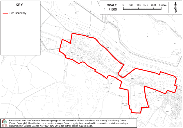
The site is allocated for employment development in Use Classes E(g) (i, ii, iii), B2 and B8.
Within the Harbour Road Employment Area, as defined on the Policies Map, business development in Use Classes E(g) (i, ii, iii), B2 and B8 will be permitted where the following criteria are met:
i. Proposals which result in a significant increase in vehicle, especially HGV, movements along Harbour Road, adjoining the A259, will only be permitted where the relevant highways authorities are satisfied that any impacts are acceptable;
ii. A ground contamination assessment has been undertaken which demonstrates that pollution risks, including to the underlying aquifer, will be managed appropriately through the development process;
iii. Proposals with frontages to Harbour Road include a comprehensive landscaping strategy to improve the overall appearance of development;
iv. The development has no adverse effect on the integrity of the adjacent Dungeness, Romney Marsh and Rye Bay SSSI, Special Protection Area and Ramsar Site, the Dungeness SAC or the Rye Harbour SSSI, and accords with Policy ENV8 – Habitats and Species, and Policy ENV11 - Sustainable Access and Recreation Management Strategy (SARMS);
v. A site-specific flood risk assessment has been undertaken which demonstrates that the development will be safe for its lifetime, taking account of the vulnerability of its users, without increasing flood risk elsewhere, and where possible, will reduce flood risk overall;
vi. There are no adverse impacts on the capacity of wharves for the landing, processing, handling or associated storage of minerals; or on safeguarded waste management operations; and
vii. An appropriate foul and surface water drainage scheme is provided, in accordance with Policies ENV2, ENV3 and ENV4.
13.125The Harbour Road employment area is a long-established concentration of industrial uses, bisected by Harbour Road. Much of the employment land has a very stark industrial appearance with many buildings close to the road. It is within Flood Zone 3; parts of it are affected by ground contamination; and it adjoins designated nature conservation sites. The area has been subject to a supportive employment policy since 2006 and given the importance of the area to the local economy, it is appropriate for this to continue.
13.126There are opportunities for further intensification of employment uses on brownfield sites at Harbour Road as this would not encroach into the protected sites. All proposals will need to include a site-specific flood risk assessment and measures to alleviate the potential risks from flooding, appropriate to the scale and nature of the development.
13.127The employment area incorporates two wharves (one of which is currently operational). One function of the wharf is the landing of minerals and, in accordance with the Waste and Minerals Local Plan, it will be necessary for proposals that could affect the wharf to demonstrate that the capacity for landing, processing, handling and associated storage of minerals is safeguarded and that there is no net loss of capacity within Rye Port. It is also important that future development does not prejudice operations at safeguarded waste management sites. The area is within the Rye Harbour Minerals and Waste Consultation Areas and consequently, consultation with the Minerals and Waste Planning Authority will be carried out for all development proposals.
13.128In view of the proximity of the site to the international wildlife designations and the potential for additional impacts, development will be required to ensure that there is no adverse effect on the integrity of the SPA/Ramsar site, in line with the Habitats Regulations and the provisions of Policy ENV11 (Sustainable Access and Recreation Management Strategy (SARMS)).
13.129Development will also need to include provision for appropriate foul and surface water drainage, having regard to sewer provision and existing levels of contamination. The scheme should include elements of SuDS where practicable, although these will need to be carefully designed having regard to the high-water table and risk of underlying contamination.
13.130There is currently some 17,480 sqm potential supply of employment floorspace in the Harbour Road Employment Area (comprised of areas with extant planning permissions and expired planning permissions) and while the individual sites are not specifically allocated through this Plan it forms part of the anticipated employment land supply over the plan period.
