
Rother Local Plan 2025-2042 Regulation 19 (pre-submission) version September 2026
Chapter 10: Bexhill Sub-Area: Vision, Strategy and Site Allocations
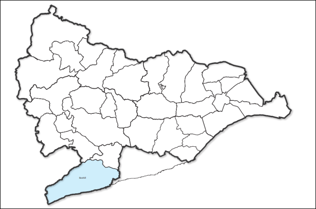
Vision for Bexhill Comment
Bexhill will be the key focus for sustainable residential and commercial growth, primarily within the urban area on brownfield sites and at its edges through ‘live well locally’ urban extensions on greenfield sites. There is potential to deliver some 4,474 dwellings and 78,225 sqm of employment floorspace across the Bexhill sub-area through site allocations.
Supporting infrastructure will be delivered to serve the growing local and wider communities that live, work, and visit the area. Development opportunities will be realised across the town, and development densities will be maximised especially within close proximity to the main town centre and key public transport connections including Bexhill railway station.
The ‘broad locations’ of west and north Bexhill will continue to grow as ‘live well locally’ urban extensions, developed sensitively and at higher densities where appropriate and sustainable to do so. Development will be well connected to the main urban areas, local neighbourhoods through integrated sustainable transport options, including active travel routes (forming a Bexhill Cycle Network connected to the National cycle network) as well as by car. Growth will only occur in areas that are well connected to the existing transport network, helping to deliver improvements to the junctions and design of the existing A259 and other key routes. There will be improvements in EV charging infrastructure across the sub-area to support a shift to electric vehicles, benefiting air quality and supporting the Plan’s Green to the Core objectives.
Connections and accessibility to nearby settlements will be enhanced through improved public transport, active travel and road networks and station capacity. This will ensure that wider services and facilities can continue to be accessed, enabling residents to live well locally and have healthy lifestyles. There will be improvements to health inequalities and wellbeing, enabling communities to lead healthy and active lifestyles.
A strong green strategic gap will be retained between Bexhill and Hastings, with the Combe Valley Countryside Park forming an important area for recreation and biodiversity. This will avoid coalescence, ensuring that both larger settlements maintain their distinct identities and landscape character at their edges.
Bexhill’s heritage assets will be conserved, and its cultural offer, centred on the Grade I listed De La Warr Pavilion and the seafront, will be enhanced.
Where development is within the hydrological catchment area of the Pevensey Levels, higher standards of sustainable drainage systems will be delivered to avoid negative impacts on the water quality and management of this sensitive environmental area.
Bexhill will also play an active role in the Pevensey Bay to Eastbourne Coastal Management Scheme, which aims to make the coastline more resilient to coastal flooding and erosion. Through collaboration with neighbouring authorities, the Environment Agency, local communities, and partner organisations, opportunities will be explored to deliver wider community, environmental, and infrastructure benefits that align with the priorities of the Local Plan and strengthen resilience along this stretch of coastline.
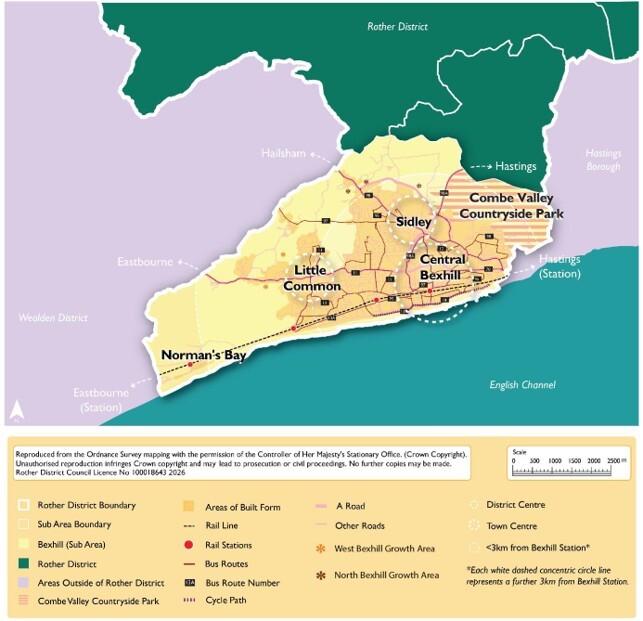
10.1The vision for Bexhill reflects how the town is intended to grow and develop over the next 17 years up to 2042. Bexhill is the most sustainable settlement for growth, reflected by its high scoring through the Settlement Study (2024), the only settlement in the district to be rated as “highly sustainable”.
10.2The construction of the Bexhill-Hastings Link Road (Combe Valley Way) and associated roads connecting with the north and north-east of Bexhill have opened up development opportunities including a sustainable new urban extension with housing, business parks, a primary school and green space at North-East Bexhill (under construction) and housing and employment growth to support Sidley (North Bexhill) (allocated for development in the Development and Site Allocations Local Plan 2019). Other larger sites in the western part of Bexhill have planning permissions. The Local Plan identifies further opportunities within the urban area and adjoining or beyond the edge of the existing development boundary with a particular emphasis on opportunities for growth in north-east and west Bexhill.
10.3In the central part of Bexhill, the redevelopment of brownfield sites offers significant sustainability benefits, with new residents ideally situated to access a wide range of services and facilities and the public transport network. Therefore, in addition to site allocations in this part of the town, the “Bexhill Central Urban Area” has been identified and this is shown in Figure 16. In this location, there will be a presumption that suitable sites for residential development will achieve higher housing densities, and lower amounts of car parking and green infrastructure may be accepted (subject to local needs), compared to on more peripheral sites (which tend to be greenfield). In addition, intensification of existing development will generally be supported, subject to other Local Plan policies. The Bexhill Central Urban Area is the subject of Policy BX1.
10.4In addition to the Bexhill Urban Area policy and designation, other area-based policies for Bexhill are included. These are the Bexhill Cultural Area (Policy BX2), London Road-Sackville Road Enhancement Area (Policy BX3) and Beeching Road Enhancement Area (Policy BX4). A policy covering Bexhill Town Centre, primary shopping area, and the two district centres of Sidley and Little Common is also included (Policy ECO6).
10.5While opportunities for further development at north and west Bexhill are identified, it is considered that the east of Bexhill has reached its development limit without expanding into areas of high flood risk, the Combe Valley Countryside Park, or Sites of Special Scientific Interest (SSSI).
10.6In west Bexhill there are other constraints in relation to the proximity to the environmental sensitivity area of the Pevensey Levels. This places higher importance on sustainable drainage measures within the identified hydrological catchment area. There are known capacity constraints on the A259 western route into Bexhill via Little Common and at the Little Common roundabout. In order to open up opportunities for development in West Bexhill, junction improvements and significant interventions, such as roundabout redesign, will be required to both alleviate road capacity and prioritise shared and active transport options on the existing network. The extent of the necessary measures and how and when they would be required has been informed by transport modelling, liaison with ESCC and National Highways and work on the Infrastructure Delivery Plan.
10.7The feasibility of the provision of a new transport corridor connecting the A259, west of Little Common roundabout, with Ninfield Road has been assessed. However, there is currently not a reasonable prospect of the delivery of a new road or ‘multi-modal corridor’ in the West Bexhill area, and this position has been confirmed by East Sussex County Council and National Highways. As such, the Local Plan only includes sites that can access the existing road transport network. However, a new western bypass for Bexhill remains a long-term aspiration of the Council, in order to improve east-west transportation across the district generally, remove heavy traffic from the roads of Bexhill and release more land for development. Any development in west and north Bexhill should focus on providing sustainable, active travel options, helping shift travel patterns and contributing to better connectivity between the edges of the town and the Town Centre and district centres, providing sustainable transport routes.
10.8In accordance with national planning policy, the development strategy and vision for Bexhill seeks to make as much use as possible of previously developed, or “brownfield” land to accommodate development needs. However, development on greenfield land will be necessary to meet local needs due to the lack of available brownfield sites. It will be essential to ensure that any greenfield growth forming urban extensions are not isolated standalone developments or settlement areas, and that they form part of well-connected and sustainable communities that contribute to radically reducing carbon emissions. For example, the level of new development proposed in West and North Bexhill is likely to require the provision of new primary school capacity, and a new primary school with nursery provision in each of these growth areas will significantly enhance their sustainability credentials by supporting new residents in accessing the services and facilities they need within a reasonable walking distance.
10.9Any development in Bexhill will need to offer enhancements and biodiversity net gain, while being sensitive to historic landscape character. There are clear opportunities to improve the nature, landscape and recreation value of adjoining greenfield land to development sites to help mitigate the loss of some open land.
10.10 The gap between Bexhill and Hastings/St Leonards is a valuable green lung between the towns. In this location approximately 600 hectares is designated as the Combe Valley Countryside Park to respond to a green infrastructure deficit in the area and provide a key area for leisure, recreation and biodiversity. While the landfill site which is central to the park has ceased to operate, there is continued use for waste collection and these sites are excluded from the Countryside Park in line with ESCC’s Waste and Minerals Local Plan. There may also be future opportunities for solar power at the landfill site, which will not in itself become publicly accessible as part of the Countryside Park for many years to come due to the time needed for it to settle and become safe. This is identified through policies of the Plan.
10.11There are neighbouring smaller settlements surrounding Bexhill that rely on services and facilities within Bexhill and/or Hastings and Battle to help meet local needs. While the majority of residents in nearby Crowhurst, Lunsford Cross, Normans Bay and Catsfield may travel by car to access services and facilities there is potential to strengthen overall public transport opportunities and build on these connections, including outside the local authority boundary such as Ninfield in Wealden. The settlements of Crowhurst and Catsfield have not been included as part of the Bexhill spatial sub-area but are included in the Hastings and Battle sub-areas, so that identified growth is only accounted for once.
10.12 Growth in Bexhill provides a clear opportunity to:
- enable strategic planning matters such as the delivery of strategic infrastructure to be resolved through continuous cross-boundary joint working between RDC and HBC;
- increase the supply of housing and jobs;
- contribute to the enhancement of the Combe Valley Countryside Park by improving access to the countryside while protecting sensitive habitats and species, supporting biodiversity net gain and the priorities and measures of the Local Nature Recovery Strategy, and the maintenance of the water network;
- improve the provision of sustainable bus services, cycling, wheeling and walking opportunities and connections across Bexhill as a whole (including to key transport hubs, specifically Bexhill rail station), and to its neighbouring villages and settlements; and
- improve services and facilities within Bexhill, delivering important infrastructure alongside new development to ensure growth is sustainable and has wider benefits to the whole of the town.
10.13Figure 10.2 sets out the quantum of development allocated in the Bexhill sub-area in terms of the numbers of dwellings and the amount of employment floorspace to be delivered over the Plan period. These figures have been derived from the total amount of development allocated through the site allocations.
Figure 10.2: Bexhill - Quantum of Development
|
Settlement Area |
Total housing (dwelling nos) |
Total employment floorspace (sqm) |
|
Bexhill |
4,474 |
78,225 |
Sustainability Coding for Settlements (Source: Rother Settlement Study, 2024)
|
Highly sustainable |
Very Good sustainability |
Good sustainability |
Fair sustainability |
Poor sustainability |
Very Poor sustainability |
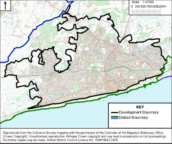
Bexhill - Central Area
Parish: Bexhill
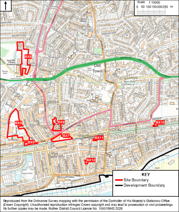
10.14The central area of Bexhill benefits from an excellent range of services and facilities, cultural assets, access to the mainline railway station and good bus services. However, there are things that need improving, including more pedestrian and cycle-friendly routes to enable people to travel around sustainably. There are also constraints including flood risks, and important assets that require protection, including public open spaces and the two Conservation Areas.
10.15In the main, opportunities for development in the central area will arise on brownfield sites. In accordance with national planning policy, it is important that developments make the best use of land, and avoid homes being built at low densities.
10.16Bexhill is benefiting from £20 million government funding through the Pride in Place Programme. To plan how the funding will be spent to improve the town, the Bexhill-on-Sea Place Plan, and an associated 4-Year Investment Plan, has been developed by the Bexhill Neighbourhood Board, a partnership of local stakeholders. The Place Plan encompasses the entire town of Bexhill, with strategic emphasis on the town centre. The Place Plan and the Local Plan are intended to align closely in their shared vision for improving Bexhill. This includes celebrating Bexhill’s heritage and enhancing the public realm, supporting opportunities for residents through improved access to skills, jobs and housing, and strengthening connections between the town centre, the coast, natural assets and neighbouring communities. Together, these plans provide a coordinated framework for investment, spatial planning and delivery over the coming decade and beyond.
Policy BX1: Bexhill Central Urban Area Comment
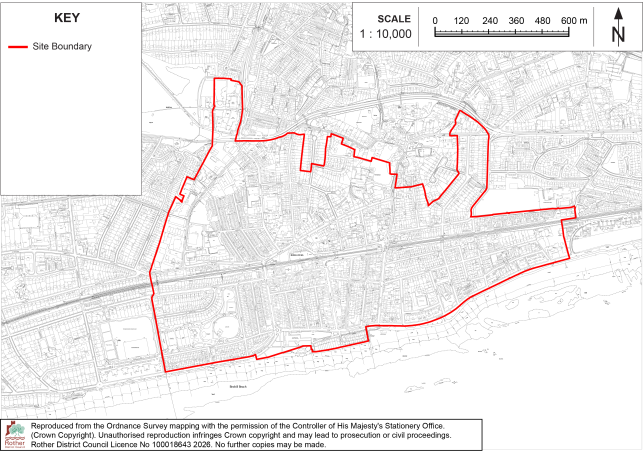
- New residential development within the designated Bexhill Central Urban Area, as defined on the Policies Map, must make optimal use of land and seek to achieve densities of at least 110 dwellings per hectare, unless there are strong reasons why this would be inappropriate.
- In the Bexhill Central Urban Area, car parking requirements for new residential developments will usually be lower than for areas that are less well served by public transport[2]. Improvements to pedestrian and cycle infrastructure, including safe and convenient connections to public transport facilities will be required.
- Proposals that intensify existing development to increase densities will generally be supported, provided they demonstrate high-quality design, preserve or enhance the significance of any heritage assets (whether designated or non-designated) and protect residential amenity.
- All development should incorporate measures to support climate resilience and sustainability, including energy-efficient design, sustainable drainage systems (SuDS) and biodiversity enhancements in accordance with the Local Plan policies and the Core Measures identified in the Local Nature Recovery Strategy. Where appropriate, the Urban Greening Factor (UGF) should be used to assess and guide the quantity and quality of green infrastructure provided on-site, in line with Natural England’s Green Infrastructure Framework.
- Larger-scale developments should incorporate a mix of uses that complement existing services and facilities in the town and deliver necessary improvements to infrastructure in accordance with Policy INF1 (Strategic Infrastructure Requirements).
- Within the Bexhill Town Centre Conservation Area, and where development affects any other heritage asset, development must accord with Policy HER1. Development within or adjacent to a Conservation Area must preserve and enhance the character or appearance of the Conservation Area, responding carefully to the area’s heritage context, particularly in terms of scale, materials and street frontage.
- Within the Bexhill Town Centre and Primary Shopping Area, development must accord with Policy ECO6 of the Local Plan.
10.17In planning for the future of Bexhill, a distinction is made between the central urban area and suburban areas. The Bexhill Central Urban Area has been identified as an area within reasonable walking distance of Bexhill mainline railway station and the services and facilities within Bexhill Town Centre. It includes the designated Town Centre and Primary Shopping Area, as well as the Beeching Road business area (see Policy BX4) and some key brownfield sites for redevelopment, identified by separate site allocation policies in this chapter.
10.18 The area also contains key heritage assets, including the Bexhill Town Centre Conservation Area and it adjoins the Old Town Conservation Area. It is also home to key facilities and attractions for residents and visitors, including Egerton Park, Bexhill Leisure Centre, Bexhill Museum and the Grade I listed De La Warr Pavilion. It overlaps with the Bexhill Cultural Area (Policy BX2).
10.19This area accommodates a mix of uses and building typologies, and its proximity to public transport and services makes it a strategic location for residential intensification. In accordance with national planning policy, the use of minimum density standards in this area is considered appropriate.
10.20To support higher densities, external residential amenity space provision may need to be reconfigured and reallocated. This could include through the provision of smaller private gardens, first-floor courtyards, roof terraces and shared communal spaces. These arrangements will be acceptable where the overall design quality is high, the proposal accords with the policies of the Live Well Locally and Housing chapters, and national guidance[3], and residential amenity is protected.
10.21While opportunities for new greenspaces and biodiversity enhancements may be more limited in the central urban area due to its built-up nature and lack of space, meaningful interventions can still be successful, as detailed in the “Urban Nature” Priorities and Core Measures in the East Sussex and Brighton and Hove Local Nature Recovery Strategy.
Policy BX2: Bexhill Cultural Area Comment
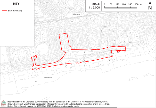
- Bexhill Cultural Area is defined on the Policies Map and will be the primary focus for arts, culture and tourism activities within the town. Within the cultural area, the loss of significant existing arts, culture, leisure and tourism uses will be resisted.
- Improvements to the quality of the public realm to complement the arts, culture and tourism offer, to improve the quality of the promenade experience, to strengthen connections between the beach and the town, and create a sense of place in keeping with the destination role of the seafront will be supported.
- Façade restoration to reinstate the original architectural features at Marina Arcade will be supported, subject to compatibility with other Local Plan policies.
- Additional infrastructure, including high-quality visitor accommodation in accordance with Policy ECO7, to support cultural activity and facilities in close proximity to the Cultural Area will be encouraged, subject to compatibility with other Local Plan policies.
10.22The Policy designates a “cultural area” to focus the enhancement of the activity and facilities offer, to improve patronage and the evening economy around the seafront as a significant amenity asset to the town.
10.23The arts, cultural and heritage offer in Bexhill is centred around the Grade I listed De La Warr Pavilion, which is internationally renowned for art installations and as a venue for live music; the adjacent, Grade II listed Colonnade and, further west, Bexhill Museum and Egerton Park. On the seafront itself are further facilities and heritage assets including the Bexhill Rowing and Sailing Clubs; the Grade II listed terrace of residential properties Marina Court Avenue; Marina Arcade, which comprises a mix of commercial and residential uses; and the war memorial.
10.24The De La Warr Pavilion, the seafront and its surrounding area is seen as a significant asset and hub for cultural and social activity within the town, being the focal point for festivals and events. The area is critical in not only providing an important local amenity and areas of public open space including blue and green infrastructure but also attracting visitors from further afield.
10.25The Rother and Hastings Tourism and Visitor Accommodation Study identifies central Bexhill as a strategic “tourism focus area”, where high-quality visitor accommodation will be supported. There is a particular need for additional hotel accommodation in the town centre. Proposals will be considered in accordance with Policy ECO7.
Policy BX3: London Road – Sackville Road Enhancement Area Comment
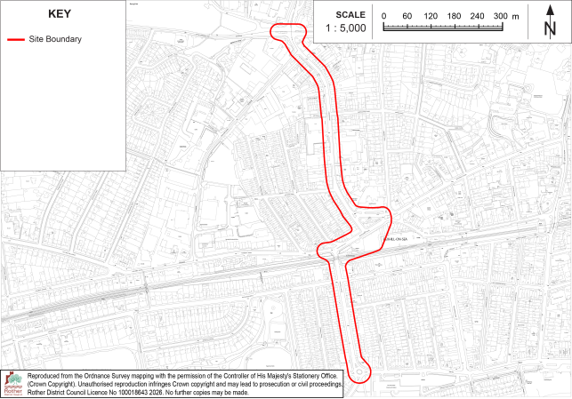
- The London Road – Sackville Road Enhancement Area, as shown on the Policies Map, is identified as a focus for townscape improvements to enhance this important gateway into Bexhill. Proposals will be supported where:
- Clear enhancements to the public realm are achieved, resulting in a stronger sense of place;
- The commercial environment for business and visitors is improved;
- The living conditions and amenities of residents are improved; and
- Improvements in terms of the safe and convenient movement for active travel and public transport and vehicles are secured.
- The District Council will work with partners, including East Sussex County Council, to meet the objectives of this policy.
10.26The London Road – Sackville Road corridor is an important gateway to Bexhill town centre, seafront and Cultural Area (see Policy BX2). However, there are shortcomings in its operation and appearance in terms of the public realm. Impeded traffic flows, queuing traffic, lack of off-street parking, poor presentation of shopfronts and prominent advertising all serve to degrade the local environment. The significance of these streets to the appeal of, and approach to, the town centre warrants policy support for their enhancement. Priorities include improvements to pedestrian safety, active travel and public transport connections, public realm enhancements and support for the commercial environment.
10.27The Area adjoins the Cultural Area (Policy BX2) and the Beeching Road Enhancement Area (Policy BX4) and lies within the Bexhill Urban Area (Policy BX1), as well as adjoining some key brownfield sites allocated for redevelopment. It is intended that all these policies work together to complement each other and secure improvements and appropriate new development in this central area of Bexhill. Sackville Road also lies within the Bexhill Conservation Area and therefore any enhancements will need to be appropriate and take account of relevant heritage considerations.
Policy BX4: Beeching Road Enhancement Area Comment
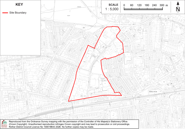
Within the Beeching Road Enhancement Area, as shown on the Policies Map, new employment and community uses which complement existing uses will be supported. New development should meet the following criteria:
- Include clear enhancements to the public realm;
- Protect the amenity of adjoining residents and businesses;
- Provide or financially contribute to the delivery of improved active travel infrastructure, including measures to encourage the use of public transport, integrating with any applicable schemes within the Local Cycling and Walking Infrastructure Plan and the East Sussex Local Transport Plan;
- Be of a high design quality, contributing to improving the appearance of the locality, in accordance with Policy LWL5;
- Make efficient use of land, contributing to intensifying existing employment areas and diversifying the employment mix;
- Take opportunities, where relevant, to enhance the setting of the Grade II listed former Bexhill West Station.
10.28The Beeching Road enhancement area comprises the Beeching Road industrial estate, which is the largest industrial area in Bexhill. It includes a mixture of uses, not limited to employment but also accommodating the Police and Fire Stations, the Bexhill Diagnostic Centre and community uses including a Day Centre, Scout Hall and public car parking areas.
10.29This policy supports delivery of the Bexhill-on-Sea Place Plan, including exemplar projects for creative workspace activation, public realm improvements, and employment intensification.
10.30The Grade II listed former Bexhill West Station building at the southern edge of the Beeching Road estate plays an important role in providing a gateway to the area which should be enhanced. There is also some high-quality new development within the area, such as the Beeching Road Studios. However, much of the existing building stock and public realm remain uninspiring and of varying quality. This policy seeks to secure improvements to the appearance and design of the area and to support the diversification and intensification of the employment mix, as well as complementing improvements within the neighbouring London Road- Sackville Road Enhancement Area (Policy BX3). The Bexhill-on-Sea Place Plan particularly supports the creative industries and circular economy uses, in line with its proposals for a reuse hub and workspace activation.
10.31Active travel improvements are required in this area to provide safe and convenient routes and related infrastructure, not only within the Enhancement Area itself but also to link to the town centre, bus stops and the railway station.
10.32Parts of the area are at risk of surface water flooding, and development proposals will need to comply with Policies ENV1 to ENV3
10.33The area lies within the Bexhill Urban Area and the requirements of Policy BX1 also apply to development proposals within it.
10.34The Beeching Road Enhancement Area includes a largely vacant plot in the south-eastern section of the industrial estate, which is also separately allocated for a residential-led mixed use development through Policy BX5. Development proposals for the BX5 area will also need to comply with Policy BX4 through the provision of an improved public realm, and improved active travel connections to Beeching Road, Terminus Road and Victoria Road/ Reginald Road and onwards towards the Town Centre.
Policy BX5: Land south-east of Beeching Road Comment
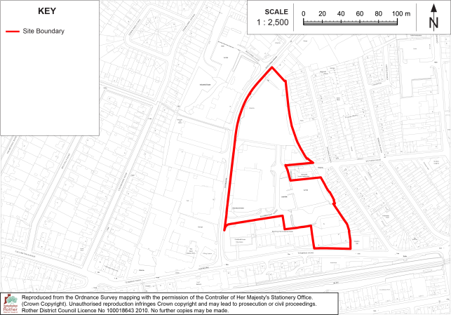
The site is allocated for a residential-led, mixed-use development comprising:
- Some 200 dwellings comprising a mix of terraced houses, maisonettes and apartments;
- Commercial uses, subject to demand, which could include convenience floorspace (retail) use limited to food and ancillary retail sales, or other employment uses;
- Community uses which could include a medical centre, community hub and public car parking.
Development on this site must:
- Provide a policy-compliant amount of on-site affordable housing in line with policy HOU2 of the Rother Local Plan;
- Comply with the requirements of Policies BX1 (Bexhill Urban Area) and BX4 (Beeching Road Enhancement Area) including through the provision of an improved public realm, and improved pedestrian and cycle connections to Beeching Road, Terminus Road and Victoria Road/ Reginald Road and onwards towards the Town Centre;
- Provide financial contributions towards the improvement of public transport to serve the development;
- If retail development is included, provide a direct frontage onto Terminus Road to make a positive contribution to linked trips and create a visual connection with the Town Centre;
- Ensure the protection of the residential amenities of adjoining and new occupiers;
- Include an assessment of the options to re-provide the existing coach and lorry park, in liaison with the District Council, and make suitable alternative provision if required;
- Include an 8-metre built development exclusion zone from either side of the main river culverts which pass through the site, to allow access to the existing outfall;
- Incorporate the recommendations of the Level 2 Strategic Flood Risk Assessment.
10.35This is a brownfield site in the south-eastern part of the Beeching Road industrial estate. It is within the Urban Area Type, has a site size of 2.81 hectares and an indicative developable area of 2 hectares. It is allocated for some 200 dwellings as part of a mixed-use scheme at an indicative residential density of 120 dwellings per hectare.
10.36The site is likely to come forward for redevelopment in phases, with the central section (recently cleared) available in the short term. The northern section (also cleared) could accommodate a new GP surgery. The existing commercial and industrial units in the eastern and southern parts of the site are currently occupied but could become available for redevelopment later on in the Plan period, subject to the relocation of the current occupiers. The area currently used for public car parking in the eastern part of the site could potentially be relocated for redevelopment, but this would require careful consideration to prevent any adverse effects on the wider Beeching Road enhancement area or nearby Bexhill town centre.
10.37There are significant level differences across the site, falling from Beeching Road in the west towards the eastern boundary. The northern section of the site has been cleared, while the southern section includes some older style industrial buildings (some vacant) as well as a veterinary surgery and scout hut, and areas used for coach and public car parking. There is a Police Station adjacent to the site and predominantly two-storey residential properties along the eastern boundary (Reginald Road).
10.38There are two culverts which run through the site which would have a bearing on the siting of new buildings, requiring an 8 metres easement from each side of the culverts. The site lies within the Cuckmere and Pevensey Management Catchment (but not the Pevensey Levels Hydrological Catchment), and a large portion of the site is at risk of surface water flooding. Therefore, early pre-application engagement with the Lead Local Flood Authority and the Pevensey and Cuckmere Water Level Management Board will be needed, together with a site-specific flood risk assessment and appropriate Sustainable Drainage (SuDS) in accordance with Policies ENV1-3. Development will need to incorporate recommendations from the Level 2 Strategic Flood Risk Assessment, as follows:
- Development will need to be sympathetic to the surface water ponding in the southern part of the site. A sequential approach should be undertaken, by locating the most vulnerable aspects of development in areas of lowest flood risk.
- Consideration of land raising and flood storage compensation would be required if development is to be located within the areas at risk of flooding. Flood storage compensation would need to be provided on a level-for-level, volume-for-volume basis and would need to be accompanied by site-specific hydraulic modelling (including the culverted Egerton Stream) evidencing that ground modifications did not impact on flood risk elsewhere.
- Blockage modelling should be conducted as part of an FRA to assess the residual risk associated with potential blockage of the culverts on the Egerton Stream beneath Beeching Road and Terminus Road.
- A buffer distance from the Main River (at least 8m) will need to be maintained to allow access and maintenance.
- Where possible the existing culvert should be removed and the channel re-naturalised.
- Utilise SuDS with multiple benefits throughout the site, particularly in areas of predicted surface water ponding.
- A Flood Response Plan will be required as the primary access route within the site (Wainright Road) is predicted to be affected during the surface water 1% AEP plus climate change event.
10.39The site’s sustainable location, in walking distance of Bexhill town centre and railway station, and adjacent to a large residential area to the east and within the Bexhill Urban Area (Policy BX1) makes it suitable for high density residential development. However, this will need to be sensitively designed and sited to ensure the protection of the amenity of future occupiers, having regard to the adjoining industrial estate.
10.40Convenience goods retail could also be acceptable at the site, subject to the proposal passing the sequential test and a retail impact assessment in accordance with Policy ECO6 (given the site’s edge of centre location), although the site was allocated for this use in the previous Local Plan (adopted 2019) and such a use has not come forward in that time. Additional commercial and business development could be accommodated as part of the site’s redevelopment, which should include the re-provision of any existing employment floorspace lost adjacent to the site’s southern boundary. Community uses would also be suitable within the site, and the retention of some public car parking.
10.41The site is close to the A259 which is part of the Strategic Road Network and therefore an appropriate Transport Assessment will be required in accordance with Policy INF2, and there will be a need to comply with any requirements of National Highways and the Local Highway Authority.
Policy BX6: Land adjacent to Bexhill Town Hall Comment
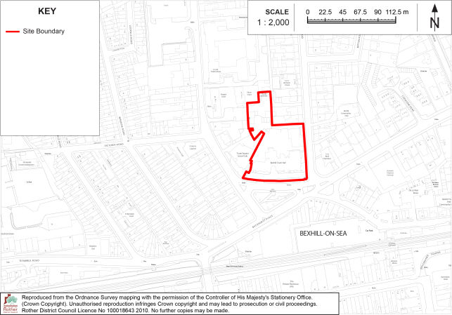
The site is allocated for a mixed-use development comprising:
- The retention of Bexhill Town Hall;
- The retention of existing office accommodation in the Amherst Road building;
- The conversion of Villa 1 and Villa 2 from office accommodation to residential use comprising some 8 apartments;
- The construction of a new residential building in the north-western part of the site to accommodate some 28 apartments.
Development on this site must:
- Provide a policy-compliant amount of on-site affordable housing in line with policy HOU2 of the Rother Local Plan;
- Preserve the setting of the Grade II listed building, Bexhill Town Hall;
- Protect the residential amenity of adjoining occupiers;
- Include improved pedestrian and cycle links to the new residential parts of the development;
- Phase the occupation of development to align with the delivery of sewerage infrastructure, in consultation with the service provider.
10.42This is a brownfield site within Bexhill Town Centre. It is within the Urban Area Type, has a site size of 0.6 hectares and an indicative developable area (for a new building) of 0.1 hectares. It is allocated for some 36 dwellings as part of a mixed-use scheme at an indicative residential density of 200 dwellings per hectare.
10.43The eastern part of the site contains Bexhill Town Hall, a Grade II listed building, and a 20th century, four storey office building to the rear. Both of these buildings are in use as offices and would be retained. The western part of the site contains a pair of Victorian villas with 20th century extensions, also currently in office use on short-term commercial leases, and an open yard to the rear which formerly accommodated a mechanic’s business.
10.44The western part of the site provides an opportunity for redevelopment for residential use, through the construction of a new residential building within the open yard in the north-western section (which is likely to come forward in the short term), and the conversion of the Villas (which could come forward later in the Plan period). Given the sustainable location and the constrained nature of the site, a high density, high-quality residential development is appropriate. While some car parking for the new residential development may be achieved on site, the development should take advantage of its sustainable location and include measures to encourage and improve pedestrian and cycle use and access to public transport.
10.45The loss of offices (a main Town Centre use, as defined in national planning policy) is generally resisted through planning policy, however, legislation grants significant “permitted development” rights for the conversion of small offices to residential uses, although these may not apply in this case due to the site adjoining a listed building. Notwithstanding this, the Villas are not ideally suited to office use, being originally converted from residential use. The small loss of converted office space would be offset by the benefits arising from the provision of 8 new residential units in a highly sustainable location within walking distance of services, facilities and public transport.
10.46Southern Water has advised that the site may have limited local network (sewerage) capacity, and phasing of development may therefore be needed alongside network reinforcement prior to occupation of the total number of dwellings.
10.47The site lies within the Cuckmere and Pevensey Management Catchment (but not the Pevensey Levels hydrological catchment), and part of the site is at risk of surface water flooding. Therefore, early pre-application engagement with the Lead Local Flood Authority and the Pevensey and Cuckmere Water Level Management Board will be needed, together with a site-specific flood risk assessment and appropriate Sustainable Drainage (SuDS) in accordance with Policies ENV1-3.
Policy BX7: Sainsbury’s site, 1 Buckhurst Place Comment
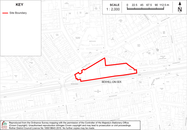
The site is allocated for a mixed-use redevelopment comprising:
- Retention of the retail (supermarket) use together with separate small retail units fronting Town Hall Square; and
- Up to 75 dwellings comprising apartments above the retail use.
Development on this site must:
- Provide a policy-compliant amount of on-site affordable housing in line with policy HOU2 of the Rother Local Plan;
- Be informed by a comprehensive site masterplan which demonstrates how the retail and residential uses, public realm, landscaping, car parking and access will be accommodated within the site;
- Include clear enhancements to the public realm including an improved active frontage onto Buckhurst Place/ Town Hall Square;
- Protect the amenity of adjoining residents and businesses;
- Provide for improved active travel and public transport infrastructure within the site and linking it to Buckhurst Place and Station Road and onwards towards the railway station;
- Include the conservation and appropriate re-display of the three concrete murals by Henry Collins and Joyce Millicent Pallot currently within the site;
- Preserve the setting of the nearby Grade II listed buildings, The Lane Memorial and Bexhill Town Hall, and the Bexhill Town Centre Conservation Area;
- Phase the occupation of development to align with the delivery of sewerage infrastructure, in consultation with the service provider;
- Incorporate the recommendations of the Level 2 Strategic Flood Risk Assessment.
10.48The site comprises a two storey, 1970s building which accommodates a supermarket and a separate small residential unit on its ground floor, an adjoining large car parking area accessed from Station Road, and a service yard. It is within Bexhill town centre but outside the Conservation Area, and just north of the railway line.
10.49The site is within the Urban Area Type, has a site size of 0.67 hectares and an indicative developable area of 0.4 hectares (excluding car parking). It is allocated for some 75 dwellings as part of a mixed-use scheme at an indicative residential density of 180 dwellings per hectare.
10.50The site offers an opportunity for redevelopment to improve its appearance, public realm, access, and its relationship with the town centre. Its sustainable location and large size mean that it could accommodate a high number of residential units at a high density above retail use, which should be retained on the ground floor.
10.51The site has some heritage sensitivities including its proximity to listed buildings and the conservation area and also three concrete murals within the site, which are recognised for their importance by the 20th Century Society. The policy requirements reflect these.
10.52The site lies within the Cuckmere and Pevensey Management Catchment (but not the Pevensey Levels Hydrological Catchment), and part of the site is at risk of surface water flooding. Therefore, early pre-application engagement with the Lead Local Flood Authority and the Pevensey and Cuckmere Water Level Management Board will be needed, together with a site-specific flood risk assessment and appropriate Sustainable Drainage (SuDS) in accordance with Policies ENV1-3. Development will need to incorporate recommendations from the Level 2 Strategic Flood Risk Assessment, as follows:
- Demonstrate through a site-specific FRA that the proposed development will be safe for its lifetime, taking account of the vulnerability of its users and potentially locating the more vulnerable aspects of the development in lower risk areas (e.g. in the eastern part of the site).
- Utilise SuDS with multiple benefits throughout the site, particularly in areas of predicted surface water ponding.
- A Flood Response Plan will be required if properties or primary access routes are shown to be impacted during the design flood event.
Policy BX8: Former Bexhill High School site, Down Road Comment
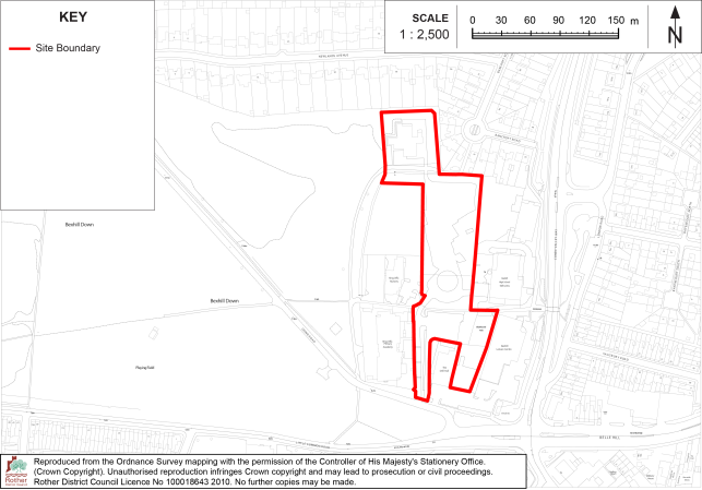
The site is allocated for a residential development comprising some 80 dwellings.
Development on this site must:
- Provide a policy-compliant amount of on-site affordable housing in line with policy HOU2 of the Rother Local Plan;
- Be delivered through a comprehensive masterplan, ensuring a coordinated approach to housing, open space, landscaping, and public realm;
- Provide a Green Infrastructure framework that retains and enhances habitats, alongside Sustainable Drainage (SuDS) measures;
- Provide children’s play space within public open space, in accordance with the approved masterplan;
- Provide vehicular access from Down Road incorporating necessary on-site and off-site highways works;
- Provide internal pedestrian and cycle connections, retaining the existing Public Rights of Way and incorporating north–south linkages to the east of the site;
- Maintain access to the adjacent Leisure Centre and Drill Hall;
- Retain and enhance existing landscape buffers, particularly on the northern boundary;
- Provide ancillary car/coach drop-off areas for the adjacent school;
- Prepare and implement a Travel Plan to support sustainable travel choices for residents.
10.53This vacant, brownfield site, formerly occupied by Bexhill High School, is located north of the Town Centre close to the junction of Combe Valley Way and the A259 and forms a prominent gateway to the town. Bexhill Leisure Centre and a former Skills Centre lie to the east, with King Offa Primary School to the west, and a large area of public open space, Bexhill Down, further west. There is a Ministry of Defence (MoD) Drill Hall to the south.
10.54The site is within the Urban Area Type, has a site size of 1.65 hectares and an indicative developable area of 1 hectare. It is allocated for some 80 dwellings at an indicative residential density of 80 dwellings per hectare. It is acknowledged this is below the density required through Policy BX1, however this site is subject to a planning permission for a lower number of dwellings and the allocation reflects a compromise, taking into account the site constraints.
10.55Two public footpaths cross the site, providing connections from Bancroft Road to Bexhill Down and linking to the Combe Valley Way underpass. An Archaeological Notification Area covers part of the site broadly in the southern section and development would need to comply with Policy HER1. The northern section of the site is bordered by a wider Area that Could become of Importance for Biodiversity (ACIB), as defined by the East Sussex Local Nature Recover Strategy (LNRS). Any proposed scheme will be required to contribute to the measures and objectives of the LNRS.
10.56The site lies within the Cuckmere and Pevensey Management Catchment (but not the Pevensey Levels Hydrological Catchment), and the southern part of the site is within Flood Zone 2 and at risk of surface water flooding. Therefore, early pre-application engagement with the Lead Local Flood Authority and the Pevensey and Cuckmere Water Level Management Board will be needed, together with a site-specific flood risk assessment and appropriate Sustainable Drainage (SuDS) in accordance with Policies ENV1-3.
10.57The allocation seeks to deliver a high-quality, accessible residential development within walking distance of the Town Centre and public transport connections.
10.58The site is very close to the A259 which is part of the Strategic Road Network. Therefore, an appropriate Transport Assessment will be required in accordance with Policy INF2 and there will be a need to comply with any requirements from National Highways and the Local Highway Authority.
Policy BX9: Land south of Terminus Road Comment
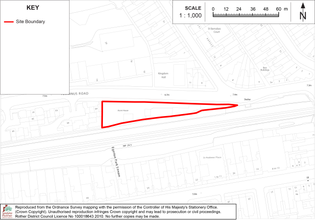
The site is allocated for residential development comprising some 14 dwellings.
Development on this site must:
- Provide a policy-compliant amount of on-site affordable housing in line with policy HOU2 of the Rother Local Plan;
- Retain and enhance existing boundary landscaping on the southern boundary;
- Improve the appearance of the frontage onto Terminus Road, including appropriate landscaping;
- Include suitable boundary fencing and noise mitigation measures on the southern boundary to protect the amenity of future occupiers;
- Retain an 8-metre built development exclusion zone from the main river culvert along the western boundary;
- Be planned to ensure future access to existing sewerage infrastructure (surface water culvert in the western part of the site) for maintenance and upsizing purposes;
- Incorporate the recommendations of the Level 2 Strategic Flood Risk Assessment.
10.59This is a brownfield site currently occupied by car sales and car wash businesses and a small office, and an adjoining small plot of land.
10.60The site is within the Urban Area Type, has a site size of 0.19 hectares and an indicative developable area of 0.13 hectare. It is allocated for some 14 dwellings at an indicative residential density of 108 dwellings per hectare.
10.61The site is bound by the railway line to the south and residential development to the west, with the Beeching Road industrial estate on the opposite side of the road to the north. Network Rail has highlighted the need for suitable boundary fencing and noise mitigation measures to protect future occupiers.
10.62There are an underground surface water culvert and a separate main river culvert in the western part of the site, which will influence the layout of the development. It is expected that built development on the site will be restricted to the eastern part of the site.
10.63The site lies within the Cuckmere and Pevensey Management Catchment (but not the Pevensey Levels Hydrological Catchment), and the western part of the site is at risk of surface water flooding. Therefore, early engagement with the Lead Local Flood Authority and the Pevensey and Cuckmere Water Level Management Board will be needed, together with a site-specific flood risk assessment and appropriate Sustainable Drainage (SuDS) in accordance with Policies ENV1-3. Development will need to incorporate recommendations from the Level 2 Strategic Flood Risk Assessment, as follows:
- Development will need to be sympathetic to the surface water ponding in the western part of the site. A sequential approach should be undertaken, by locating the most vulnerable aspects of development in areas of lowest flood risk.
- Blockage modelling should be conducted as part of an FRA to assess the residual risk associated with potential blockage of the culverts on the Egerton Stream beneath the railway line and Terminus Road.
- A buffer distance from the Main River (at least 8m) will need to be maintained to allow access and maintenance.
- Utilise SuDS with multiple benefits throughout the site, particularly in areas of predicted surface water ponding.
10.64Previous planning appeal decisions have considered the car sales business within the site not to be an employment use and accepted that a solely residential scheme could be provided on the site without having an unacceptable impact on the Council’s employment land supply. The appeal decisions indicated that the site may only be suitable for a three-storey block of flats, given the characteristics of the locality. The inclusion of the plot to the east will result in the loss of a small office, however, this will not significantly affect the employment land supply and will allow for more dwellings on this constrained site.
Policy BX10: Land at 30 Dorset Road Comment
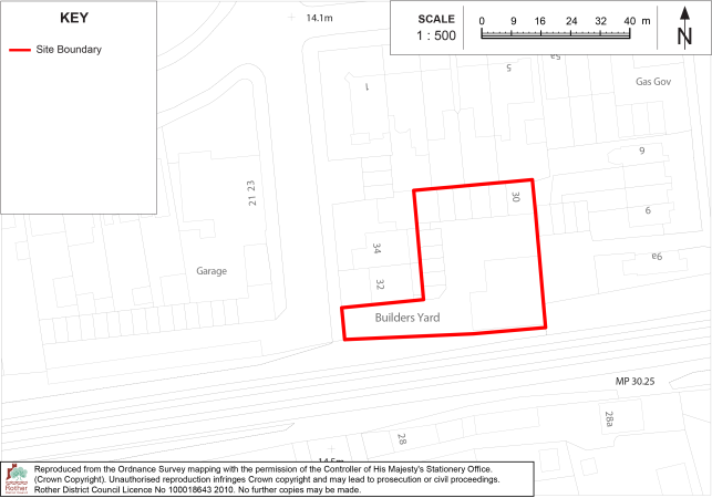
The site is allocated for a residential development comprising some 8 dwellings.
Development on this site must:
- Enhance the existing access to Dorset Road to appropriately service the development;
- Include a suitable pedestrian link to Dorset Road;
- Ensure that development does not unreasonably harm the amenities of nearby residential development in terms of loss of light, massing or overlooking;
- Include suitable boundary fencing and noise mitigation measures on the southern boundary to protect the amenity of future occupiers.
10.65The brownfield site is located behind a pair of semi-detached dwellings at Nos. 32 and 34 Dorset Road in and is currently in use as a builders’ yard.
10.66The site is within the Urban Area Type, has a site size of 0.08 hectares and an indicative developable area of 0.06 hectare. It is allocated for some 8 dwellings at an indicative residential density of 120 dwellings per hectare.
10.67The south side of the site adjoins the railway embankment. Network Rail has highlighted the need for suitable boundary fencing and noise mitigation measures to protect future occupiers.
10.68Outline planning permission was granted in 2024 for redevelopment of the existing builders’ yard to provide 8 flats with associated landscaping and parking with all matters reserved except for access which has not yet been implemented.
10.69The site lies within the Cuckmere and Pevensey Management Catchment (but not the Pevensey Levels Hydrological Catchment) although it is not shown to be at risk of flooding. Nevertheless, early pre-application engagement with the Lead Local Flood Authority and the Pevensey and Cuckmere Water Level Management Board will be needed to ensure the provision of appropriate Sustainable Drainage (SuDS) in accordance with Policy ENV3.
Policy BX11: Rear of 11 Endwell Road Comment
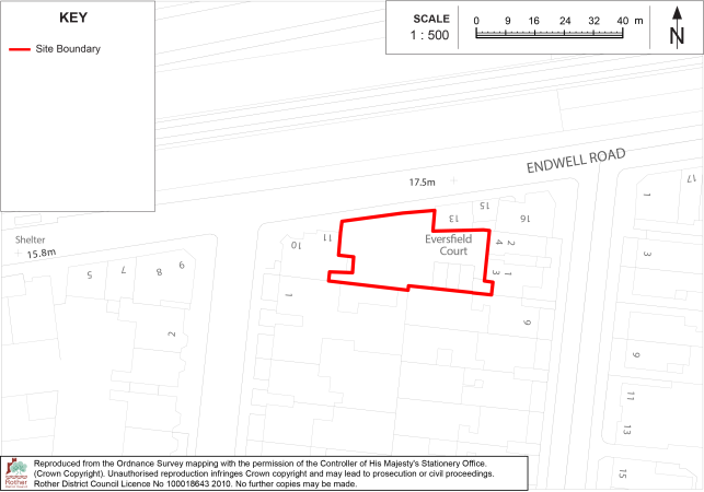
The site is allocated for a residential development comprising some 6 dwellings.
Development on this site must:
- Include new pedestrian links to Endwell Road;
- Ensure that it does not unreasonably harm the amenities of nearby residential development in terms of loss of light, massing or overlooking;
- Ensure an active frontage is provided along Endwell Road;
- Preserve and enhance the character and appearance of the Bexhill Town Centre Conservation Area in accordance with Policy HER1.
10.70The site is located on Endwell Road within Bexhill Town Centre and the Town Centre Conservation Area. It comprises a privately-owned car park with 13 parking spaces and a single storey triple-bay garage. It is flanked by mixed-use commercial and residential development on either side.
10.71The site is within the Urban Area Type, has a site size of 0.04 hectares and an indicative developable area of 0.03 hectare. It is allocated for some 8 dwellings at an indicative residential density of 200 dwellings per hectare.
10.72Planning permission was granted in 2024 for the demolition of the garage block and provision of a 3-storey building containing 6 flats, which has not yet been implemented.
10.73The site lies within the Cuckmere and Pevensey Management Catchment (but not the Pevensey Levels Hydrological Catchment) although it is not shown to be at risk of flooding. Nevertheless, early pre-application engagement with the Lead Local Flood Authority and the Pevensey and Cuckmere Water Level Management Board will be needed to ensure the provision of appropriate Sustainable Drainage (SuDS) in accordance with Policy ENV3.
Policy BX12: Eversley Road Car Park, Eversley Road Comment
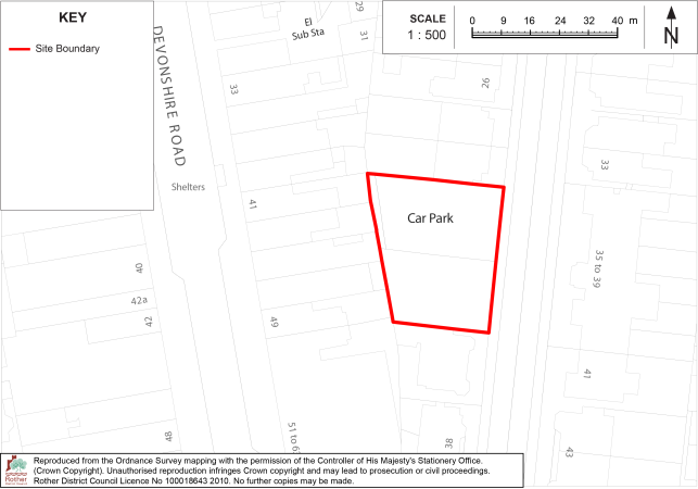
The site is allocated for a mixed-use development comprising:
- Some 10 dwellings
- The retention of public car-parking (circa ten spaces)
Development on this site must:
- Ensure that it does not unreasonably harm the amenities of nearby residential development in terms of loss of light, massing or overlooking;
- Preserve and enhance the character and appearance of the Bexhill Town Centre Conservation Area;
- Include improvements to the public realm including on its boundary with the highway at Eversley Road;
- Include improvements to active travel connections and infrastructure, including, subject to an assessment of need, public cycle parking within the site.
10.74The site is a public car park, providing some 35 spaces accessible from Bexhill Town Centre, in a largely residential street. It is within the Town Centre Conservation Area but just outside the primary shopping area and town centre.
10.75The site is within the Urban Area Type, has a site size of 0.05 hectares and an indicative developable area of 0.05 hectares. It is allocated for some 10 dwellings as part of a mixed-use scheme at an indicative residential density of 200 dwellings per hectare. A careful design will be required to protect the amenity of adjacent properties and the character of the Conservation Area.
10.76The site lies within the Cuckmere and Pevensey Management Catchment (but not the Pevensey Levels Hydrological Catchment) although it is not shown to be at any significant risk of flooding. Nevertheless, early pre-application engagement with the Lead Local Flood Authority and the Pevensey and Cuckmere Water Level Management Board will be needed to ensure the provision of appropriate Sustainable Drainage (SuDS) in accordance with Policy ENV3.
10.77While the redevelopment of the site would reduce the number of public car parking spaces, this is a sustainable location within a short walk of the railway station and bus services. There is ample on-street parking nearby and a large public car park at the De La Warr Pavilion, within a short walk of the site. The benefits of providing additional dwellings in this location are considered to over-ride the small loss of car parking.
Bexhill – Suburban Area
Parish: Bexhill
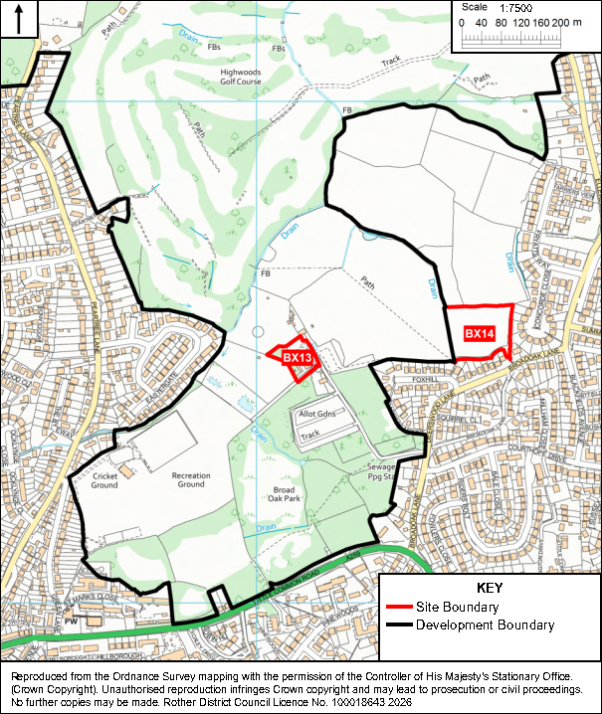
10.78The suburban area of Bexhill covers a large area outside the central urban area. The map above illustrates only a portion of it, focusing on locations where allocation sites are included. Generally, suburban areas are less centrally located in relation to key services, facilities and public transport connections, although some parts of the Bexhill suburban area do benefit from good access, including to the district centres at Sidley and Little Common.
10.79In this area there are opportunities for both brownfield and greenfield development. While the higher densities typical of the central urban area may not suit all suburban contexts, medium-density development can support walkability and local service viability. In accordance with national planning policy, it remains important that developments avoid homes being built at low densities and make optimal use of the potential of each site. Development should also respond positively to local character and contribute to a sense of place.
Policy BX13: Land at Broad Oak Park Comment
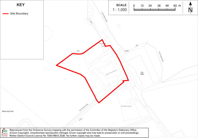
The site is allocated for residential development comprising some 8 dwellings.
Development on this site must:
- Take a farmstead approach to the site layout, retaining as much of the existing historic building fabric as possible, as informed by a historic building assessment and heritage assessment;
- Where new buildings are proposed these should be of an appropriate scale and design to ensure that any structure is not overbearing upon the historic farmyard;
- Be of an agrarian character in terms of materiality and design (including any associated parking areas);
- Maintain access to the Public Right of Way (Bexhill 65) adjacent to the site’s south-eastern boundary;
- Maintain, protect and enhance the woodland within the south-western part of the site and trees on other site boundaries, in accordance with Policy LAN3;
- Be informed by a Land Contamination Survey in accordance with Policy ENV5;
- Be subject to Habitats Regulations Assessment screening and incorporate necessary mitigation to ensure no adverse effect on the integrity of the Pevensey Levels, including appropriate Sustainable Drainage (SuDS) with at least three treatment stages, in accordance with Policy ENV3;
- Be informed by Ecological Surveys in accordance with Policy ENV8;
- Incorporate the recommendations of the Level 2 Strategic Flood Risk Assessment.
10.80The site comprises former agricultural buildings, last in use for small-scale commercial/ community uses, associated car parking and an adjoining small area of woodland. It is accessed via a narrow lane which also leads to the adjoining large area of public open space at Broad Oak Park. It is outside the Development Boundary of Bexhill and has a rural setting, close to grazing fields, woodland and open space. Nevertheless, as a brownfield site it is relatively close to the amenities of Bexhill and suitable in principle for small-scale residential redevelopment, providing it is sensitively designed to take account of the historic use of the site, the non-designated heritage asset of the remaining historic farmstead buildings and its rural setting.
10.81The site is within the Suburban Area Type, has a site size of 0.44 hectares and an indicative developable area of 0.2 hectares. It is allocated for some 8 dwellings at an indicative residential density of 40 dwellings per hectare.
10.82Woodland adjacent to the south-eastern boundary of the site forms part of a wider Area that Could become of Importance for Biodiversity (ACIB), as defined by the East Sussex Local Nature Recover Strategy (LNRS). Any proposed scheme will be required to contribute to the measures and objectives of the LNRS.
10.83The site lies within the Pevensey Levels Hydrological Catchment and is partly at risk of surface water flooding. Therefore, the proposal would need to include appropriate Sustainable Drainage (SuDS) with at least three treatment stages, in accordance with Policy ENV3. Early pre-application engagement with the Lead Local Flood Authority and the Pevensey and Cuckmere Water Level Management Board will be needed, together with a site-specific flood risk assessment. Development will need to incorporate recommendations from the Level 2 Strategic Flood Risk Assessment, as follows:
- Development will need to be sympathetic to the surface water ponding in the centre of the site. A sequential approach should be undertaken, by locating the most vulnerable aspects of development in areas of lowest flood risk.
- Demonstrate through a site-specific FRA that the proposed development will be safe for its lifetime, taking account of the vulnerability of its users.
- Utilise SuDS with multiple benefits throughout the site, particularly in areas of predicted surface water ponding.
Policy BX14: Land north of Broadoak Lane Comment
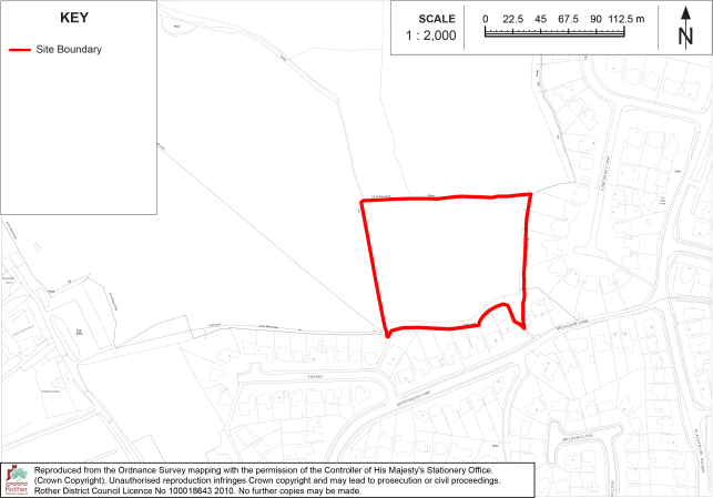
The site is allocated for residential development comprising some 35 dwellings.
Development on this site must:
- Secure a replacement area of public open space in a suitable location, to be agreed by the Council and provided prior to the commencement of development and thereafter retained as public open space;
- Provide a policy-compliant amount of on-site affordable housing in line with policy HOU2 of the Rother Local Plan;
- Include vehicular access from the adjoining land to the north;
- Include pedestrian links to the existing public footpath (Bexhill 26a) on the southern boundary;
- Retain and enhance existing mature trees and hedges on the site boundaries, other than where short sections need to be removed to facilitate access, which should be minimised as far as possible;
- Provide additional planting, street trees and landscape management and biodiversity enhancements, informed by a Landscape and Ecological Management Plan;
- Be subject to Habitats Regulations Assessment screening and incorporate necessary mitigation to ensure no adverse effect on the integrity of the Pevensey Levels, including appropriate Sustainable Drainage (SuDS) with at least three treatment stages, in accordance with Policy ENV3;
- Implement a Construction Environment Management Plan and Construction Management Plan addressing biodiversity, pollution prevention, air quality, noise mitigation, and contamination risks.
10.84The site comprises an area of open space consisting of a sloping grassed field with treed boundaries on the edge of a residential area, just south of an area of land currently being developed with 210 dwellings.
10.85The site is within the Suburban Area Type, has a site size of 1.26 hectares and an indicative developable area of 1 hectare. It is allocated for some 35 dwellings at an indicative residential density of 35 dwellings per hectare.
10.86National planning policy seeks to prevent existing open space from being built on unless certain criteria are met, including that the loss resulting from the development would be replaced by equivalent or better provision in a suitable location. This is also a condition of a deed of dedication with Fields in Trust, which the site is currently subject to (together with the adjoining, larger Broad Oak Park). While the deed of dedication is not a planning matter, it does mean that an alternative, equivalent area of public open space would need to be identified and dedicated before this field could be released for an alternative use. This would also satisfy the national planning policy requirement. The council, as landowner, is currently seeking to develop proposals to satisfy the Fields in Trust requirement, which would retain the same level of open space for public access within the same catchment area.
10.87On completion of the adjoining development, the site will be surrounded by residential development on three sides. Given the significant need for housing and the adjoining, larger area of public open space to the west, the release of this limited parcel of land can be accepted, on the basis that an equivalent replacement area of open space will be identified and secured by the Council as landowner prior to the commencement of development.
10.88There is a public footpath on the southern edge of the site but no suitable vehicular access point from Broadoak Lane, although pedestrian links could be provided. Therefore, vehicular access would need to be via the adjoining land to the north. It is likely that financial contributions towards bus services would be required as part of the development, as the area is relatively poorly served.
10.89The site lies within the Pevensey Levels Hydrological Catchment. Therefore, the proposal would need to include appropriate Sustainable Drainage (SuDS) with at least three treatment stages, in accordance with Policy ENV3. Early pre-application engagement with the Lead Local Flood Authority and the Pevensey and Cuckmere Water Level Management Board will be needed.
West Bexhill Growth Area
Parish: Bexhill
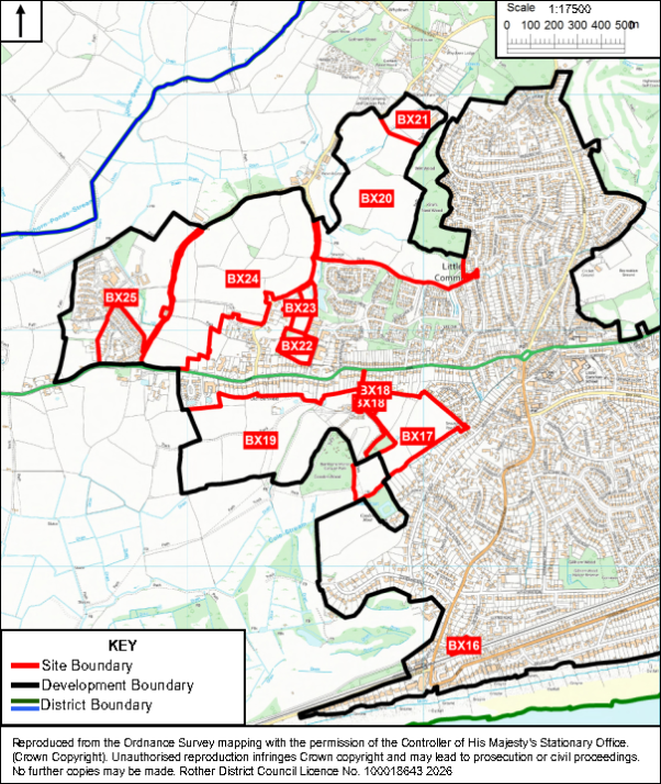
10.90The largest sites suitable for development in West Bexhill are on greenfield land, although there are also some brownfield opportunities. Some substantial sites already have planning permission or are delegated to approve, or were allocated in the previous Local Plan. This Local Plan takes forward these sites, together with some additional large sites.
10.91Impacts of development in this area on the A259 Barnhorn Road and the Habitats sites at the Pevensey Levels in particular will need to be carefully considered through planning applications. A new western road bypass of Bexhill is not anticipated for delivery during the Plan period, and consequently the allocations work within the limitations of the existing road network.
10.92The site allocations and the specific site requirements have been carefully considered, taking into account existing constraints in the West Bexhill area, including:
- Its proximity to the environmentally sensitive area of the Pevensey Levels, meaning any new development must incorporate careful sustainable drainage (SuDS) solutions comprising at least three treatment stages in accordance with Policy ENV3;
- Impacts on the A259 trunk road, including the Little Common Roundabout;
- The road network away from the A259, which (particularly in the west) comprises narrow, winding country lanes unsuited to additional traffic;
- Its sensitive landscape setting, with long views into the countryside to the south-west and north;
- Areas at risk of flooding, which effectively encircle the Growth Area to the south and north;
- The distance of many large sites from services, facilities and public transport connections in Bexhill and Little Common, meaning that without careful planning and provision of infrastructure, new residential development could be unsustainable and largely car dependent.
Policy BX15: West Bexhill Growth Area - Infrastructure Comment
- New development within the West Bexhill Growth Area must appropriately contribute to the infrastructure required to create a sustainable, “Live Well Locally” community that also meets the Local Plan’s overall priorities of being “Green to the Core” and creating “A Thriving Local Economy”.
- Infrastructure will be required to be provided in a timely manner, either by direct provision or through proportionate (to the respective quantum of residential development) financial contributions attached to the respective planning permissions.
- The development of sites which are the subject of policies BX17, BX18, BX19, BX20, BX21, BX22, BX23, BX24 and BX25 shall contribute to shared infrastructure to serve those sites through:
- Improvements to the strategic and local road networks (including any improvements to the wider road network in the Bexhill area) that are necessary to make the impacts of development acceptable, in accordance with the requirements of National Highways and the Highway Authority;
- Improvements to pedestrian and cycling infrastructure to support and enable active travel, including new and improved safe and attractive routes to Little Common District Centre and Cooden Beach railway station;
- Improvements to public transport including in terms of its provision and infrastructure;
- The provision of a new Primary School with Early Years Nursery provision, to serve the West Bexhill area within site BX24, when required by the Education Authority;
- A comprehensive network of Green and Blue Infrastructure, including attractive and landscaped public open spaces with retained mature trees and ponds, play areas for all ages, and areas for habitat creation and biodiversity enhancements, having regard to the qualitative and quantitative deficits identified by the Rother Green and Blue Infrastructure Study (2026) and the Measures and Priorities identified in the Local Nature Recovery Strategy;
- The provision of outdoor sports facilities including formal playing pitches (which may be all-weather pitches) to meet the needs of new residents, with appropriate supporting infrastructure;
- The provision of indoor meeting places within sites BX20 and BX24;
- Incorporation of appropriate Sustainable Drainage Systems (SuDS) with at least three treatment stages in accordance with Policy ENV3, with development subject to Habitats Regulations Assessment screening to demonstrate beyond reasonable scientific doubt that development can be delivered on the site without harming the integrity of the Pevensey Levels Special Area of Conservation/RAMSAR site;
- The provision of an overarching foul drainage strategy, in conjunction with Southern Water. Occupation of development to be phased to align with the delivery of sewerage infrastructure, in consultation with the service provider.
10.93There is a need for a master-planning approach to the West Bexhill Growth Area to ensure the creation of a Live Well Locally sustainable community. A strategic masterplan diagram is shown at Figure 10.3 below.
10.94The West Bexhill Strategic Masterplan provides an overarching spatial framework for coordinating development across the Growth Area. It identifies the broad relationship between development areas, local shops and services, education, health and community infrastructure, sports and recreation, strategic green and open space, retained woodland, tree belts and hedgerows, key heritage assets and the principal movement network. It also illustrates public transport connections and how individual development sites should contribute to a connected strategic active travel network, including links to existing routes, planned improvements and identified network gaps or connections that need to be secured.
10.95The masterplan is strategic and indicative rather than a detailed design or layout for individual sites. Development proposals should respond positively to the spatial principles shown, while the precise disposition of development, streets, spaces and infrastructure will be determined through the relevant site allocation policies, other policies of the Local Plan and, where required, more detailed site masterplanning. Particular importance should be given to maintaining connections between development sites and with surrounding neighbourhoods, integrating and connecting green and blue infrastructure, and ensuring that local shops and services, health and community facilities, the proposed primary school, sports and recreation provision and other infrastructure are accessible by walking, wheeling, cycling and public transport.
10.96New residential and employment development must be supported by new and improved infrastructure. This is identified in the Infrastructure Delivery Plan (IDP) and Policy BX15. The IDP will be subject to regular review, ensuring it takes account of the latest available information including on development phasing and viability. Impacts on infrastructure in adjoining Authorities is also a consideration, given the close proximity of parts of the Growth Area to the district boundary.
10.97 It is appreciated that some of the individual sites listed in Policy BX15 already benefit from planning permission (or are delegated to approve subject to a Section 106 agreement). In these cases, the infrastructure requirements of the individual site would have been secured through the permission, and this policy does not change that. However, the sites are included to allow for a situation where an existing planning permission may not be implemented.
West Bexhill Growth Area – Strategic Masterplan Comment
Strategic Masterplan Key:
|
Development: |
Green & Open Space: |
||
|
Growth Area Boundary |
Ancient Woodland |
||
|
Development Area |
Woodland, Tree Belts & Hedgerows |
||
|
Local Shops & Services |
Open Space / Green Infrastructure |
||
|
Proposed Local Shops and Services |
Sports & Recreation |
||
|
Existing Primary School |
Proposed Sports and Recreation |
||
|
Existing Secondary School |
Listed Buildings |
||
|
Potential Location for a Primary School |
District Boundary |
||
|
Employment Area |
|||
|
Transport Infrastructure: |
Health & Community: |
||
|
Existing Bus Route |
Existing GP / Health Facility |
||
|
Existing Bus Stop |
Proposed GP / Health Facility |
||
|
Proposed / Enhanced Public Transport Corridor |
Existing Community Facility |
||
|
Principal Development Access |
Proposed Community Facility |
||
|
Strategic Active Travel Network: |
|||
|
PROW - Public Right-of-Way & Existing Strategic Active Travel Route |
|||
|
Proposed upgrade of Strategic Active Travel Route |
|||
|
LCWIP Route / Planned Active Travel Improvement |
|||
|
Strategic Active Travel Connection to be Incorporated Within Development |
|||
|
Strategic Network Gap / Connection Required |
|||

Policy BX16: Gorses Car Park and Open Space, The Gorses Comment
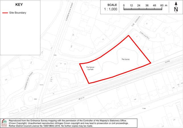
The site is allocated for residential development comprising some 10 dwellings.
Development on this site must:
- Provide a policy-compliant amount of on-site affordable housing in line with policy HOU2 of the Rother Local Plan;
- Comprise of small (1-3 bedroom) dwellings to address the needs for small dwellings in the district;
- Be limited to the existing, hard-surfaced public car parking area and not extend into the area of public open space within the site, unless any loss (which should be minimised as far as possible) would be replaced by equivalent provision in terms of quantity and quality in a suitable location;
- Include measures to protect and enhance biodiversity within the site;
- Be subject to Habitats Regulations Assessment screening and incorporate necessary mitigation to ensure no adverse effect on the integrity of the Pevensey Levels, including appropriate Sustainable Drainage (SuDS) with at least three treatment stages, in accordance with Policy ENV3;
- Incorporate the recommendations of the Level 2 Strategic Flood Risk Assessment;
- Include suitable boundary fencing and noise mitigation measures on the southern boundary to protect the amenity of future occupiers.
10.98The site comprises a small public car park and an adjoining larger area of public open space consisting of grassed and wooded areas. It is located in a relatively sustainable location within walking distance of Cooden Beach railway station and is bounded by residential development to the east and west.
10.99The site is within the Suburban Area Type, has a site size of 0.39 hectares and an indicative developable area of 0.06 hectares. It is allocated for some 10 dwellings at an indicative residential density of 166 dwellings per hectare.
10.100There is ample on-street parking in the local area available for users of the nearby railway station, and consequently, the loss of the public car park is considered acceptable, on the basis that its redevelopment would allow for the provision of small dwellings, boosting the housing supply of this accommodation type in this area of Bexhill.
10.101However, the loss of the public open space within the site would be contrary to national planning policy and consequently, any impact would need to be minimised as far as possible, and any loss replaced by equivalent provision in terms of quantity and quality in a suitable location.
10.102Given the site’s close proximity to the Pevensey Levels SSSI, Ramsar site and SAC, and the fact that the scrubland to the south of the car park is defined as an Area that Could become of Importance for Biodiversity (ACIB) in the East Sussex Local Nature Recover Strategy (LNRS), the development would need to include measures to protect and enhance biodiversity, and contribute to the measures and objectives of the LNRS.
10.103The site lies within the Pevensey Levels Hydrological Catchment. Therefore, the proposal would need to include appropriate Sustainable Drainage (SuDS) with at least three treatment stages, in accordance with Policy ENV3. Early pre-application engagement with the Lead Local Flood Authority and the Pevensey and Cuckmere Water Level Management Board will be needed. Development will need to incorporate recommendations from the Level 2 Strategic Flood Risk Assessment, as follows:
- Demonstrate through a site-specific FRA that the proposed development will be safe for its lifetime, taking account of the vulnerability of its users. A sequential approach should be undertaken, by locating the most vulnerable aspects of development in areas of lowest flood risk.
- Utilise SuDS with multiple benefits throughout the site, particularly in areas of predicted surface water ponding.
- A Flood Response Plan will also be required.
10.104The site is close to the railway line and Network Rail has highlighted the need for boundary fencing and appropriate noise mitigation measures to protect the amenity of the new dwellings. The siting and design of this would be for determination at planning application stage.
Policy BX17: Land off Spindlewood Drive Comment
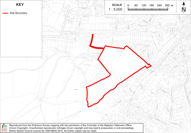
The site is allocated for residential development comprising some 146 dwellings.
Development on this site must:
- Provide a policy-compliant amount of on-site affordable housing in line with policy HOU2 of the Rother Local Plan;
- Provide highway access from Spindlewood Drive and Barnhorn Road, including offsite highway works to make the development acceptable in highway terms;
- Provide a pedestrian footpath link to Barnhorn Road and footpath improvements at the Spindlewood Drive access;
- Provide children’s play space in the form of both a Locally Equipped Area for Play (LEAP) and a Local Area for Play (LAP);
- Provide a green corridor through the centre of the site between two areas of existing adjacent woodland areas for ecological and public recreational use. The corridor will include the retention and enhancement of the existing pond only for ecological value and not as part of the SuDS system, which should form part of an enhanced buffer to the adjacent Ancient Woodland;
- Include provision for the retention and future management of a buffer zone of semi-natural habitat, at least 15 metres wide, on the south-west boundary, between the edge of development and the ancient woodland;
- Retain and enhance existing boundary planting, particularly in relation to the existing Tree Preservation Orders on adjacent sites and the north and northeastern boundaries of the site;
- Include provision for any protected species found to be using the site, including appropriate mitigation and/or compensation for any loss of habitat, retaining physical linkages through the central wildlife corridor;
- Be subject to Habitats Regulations Assessment screening and incorporate necessary mitigation to ensure no adverse effect on the integrity of the Pevensey Levels, including appropriate Sustainable Drainage (SuDS) with at least three treatment stages, in accordance with Policy ENV3;
- Protect the amenity of adjoining residential properties to the north, north-east and south-east, and the existing character of the countryside and farm complex to the south-west and west;
- Provide improvements to existing local bus stop infrastructure and make financial contribution towards improving local bus services.
10.105This greenfield site lies to the south of Barnhorn Road and west of Spindlewood Drive, Little Common. It is within the Suburban Area Type, has a site size of 7.3 hectares and an indicative developable area of 3.4 hectares. It is allocated for some 146 dwellings at an indicative residential density of 43 dwellings per hectare.
10.106The site can be accessed from both Spindlewood Drive and Barnhorn Road and is close to bus services, shops and community facilities within Little Common District Centre. Highway impacts must be carefully assessed, with any proposals required to deliver appropriate off-site mitigation. This includes consideration of cumulative impacts from other developments. One of the accesses is to come from the A259 which is part of the Strategic Road Network. Any proposed upgrade/improvement of an existing SRN access will need to be fully assessed by National Highways in line with the relevant guidance set out in DfT Circular 01/2022 and the Design Manual for Roads and Bridges (DMRB). Improvements to pedestrian and sustainable transport links are essential. This includes a direct pedestrian route from the site to Barnhorn Road, footway improvements at the Spindlewood Drive access, upgraded bus stop infrastructure, and financial contributions towards improved local bus services. A site-specific travel plan will be required to ensure the use of sustainable transport is maximised.
10.107The site lies within the Pevensey Levels Hydrological Catchment. Habitats Regulations Assessment screening will be needed, to demonstrate beyond reasonable scientific doubt that the development can be delivered on the site without harming the integrity of the Pevensey Levels Special Area of Conservation/RAMSAR site. The proposal would need to include appropriate Sustainable Drainage (SuDS) with at least three treatment stages, in accordance with Policy ENV3. Early pre-application engagement with the Lead Local Flood Authority and the Pevensey and Cuckmere Water Level Management Board will be needed.
10.108There are also areas of the site that are within Flood Zones 2 and 3 which overlaps with areas at risk of surface water flooding. This is predominantly in the south-western part of the site and along the southern boundary. A site-specific flood risk assessment will be needed.
10.109The south-western field provides open views towards the Levels and must be kept free of built development to protect the landscape setting. This area is considered most suitable for SuDS infrastructure, enabling the retention of its open character.
10.110A connection to the nearest point in the foul sewerage network with adequate capacity will be required, agreed with the service provider. Development layout should also account for the existing wastewater pumping station at Spindlewood Drive to avoid land use conflicts.
10.111There are two bands of trees that run through the site linking a wooded area to the north with Ancient Woodland to the south. This is an important landscape feature within the site and acts as a wildlife corridor between the two areas of woodland that should be retained for ecological and recreational open space. Part of the area may be suitable for children’s play space. It is recognised that the existing track bisecting the corridor (or an alternative to it) will need to be made up as part of the internal vehicular movement network. Appropriate mitigation measures to enable the safe movement of wildlife through the corridor will need to be incorporated in the detailed design. There is also a pond in this area which should be retained and enhanced for ecological purposes only and not as part of the SuDS. The pond lies adjacent to the Ancient Woodland and provides existing habitat for protected species. It would therefore be appropriate to include this area within an enhanced buffer zone to the woodland and to restrict public access to it.
10.112Elsewhere, a minimum 15m buffer between development and the Ancient Woodland should be maintained and other appropriate wildlife mitigation measures informed by a full evaluation of the site’s ecological value and potential will be required. The southern part of the site forms part of an Area that Could become of Importance for Biodiversity (ACIB), as defined in the East Sussex Local Nature Recover Strategy (LNRS), and the ancient woodland is defined in the same document as an Area of Particular Importance for Biodiversity (APIB). The development would need to include measures to protect and enhance biodiversity and contribute to the measures and objectives of the LNRS.
10.113The north-west part of the site adjacent to the historic medieval farm complex is identified as an Archaeological Notification Area and a geophysical survey of the site has identified the potential for archaeological remains to be present throughout this whole field. It will be necessary to clarify the significance of these features through trial trench testing prior to the detailed layout of development on the site being designed so that any important remains can be retained in situ.
Policy BX18: Land north of Barnhorn Manor Caravan Park Comment
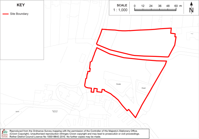
The site is allocated for residential development comprising some 20 dwellings.
Development on this site must:
- Provide a policy-compliant amount of on-site affordable housing in line with policy HOU2 of the Rother Local Plan;
- Utilise the same access from Barnhorn Road as the adjacent site subject to Policy BX17 of this Plan, including all necessary improvements to the access as required by National Highways;
- Provide for pedestrian and cycle links to the adjacent sites subject to Policies BX17 and BX19 of this Plan and to the existing public footpath network;
- Protect the setting and preserve or enhance the significance of the Grade II Listed Building, Barnhorn Manor, Lower Barnhorne, to the west of the site;
- Include a landscaping scheme to enhance the appearance of the development which includes the protection and retention of trees on the site boundaries;
- Be subject to Habitats Regulations Assessment screening and incorporate necessary mitigation to ensure no adverse effect on the integrity of the Pevensey Levels, including appropriate Sustainable Drainage (SuDS) with at least three treatment stages, in accordance with Policy ENV3;
- Phase the occupation of development to align with the delivery of sewerage infrastructure, in consultation with the service provider.
10.114This site lies just west of the land subject to Policy BX17. It is within the Live Well Locally Area Type, has a site size of 1 hectare and an indicative developable area of 0.5 hectares. It is allocated for some 20 dwellings at an indicative residential density of 40 dwellings per hectare.
10.115The site previously contained a number of agricultural buildings including livestock barns although most of these have now been demolished, as agricultural activity in the area has been reduced. The site is sandwiched in between existing residential development on the southern side of Barnhorn Road and Oak Tree Place, planned residential development to the east, and Barnhorn Manor Caravan Park to the south (which is itself contained within the land subject to Policy BX19).
10.116The site provides an opportunity for a small extension to the residential development at the adjoining site (BX17), utilising the same access point from A259/Barnhorn Road, part of the Strategic Road Network (SRN). Any proposed upgrade/improvement of an existing SRN access will need to be fully assessed by National Highways in line with the relevant guidance set out in DfT Circular 01/2022 and the Design Manual for Roads and Bridges (DMRB).
10.117The site lies within the Pevensey Levels Hydrological Catchment and there are small areas at risk of surface water flooding including waterbodies in the eastern part of the site. Therefore, the proposal would need to include appropriate Sustainable Drainage (SuDS) with at least three treatment stages, in accordance with Policy ENV3. Early pre-application engagement with the Lead Local Flood Authority and the Pevensey and Cuckmere Water Level Management Board will be needed.
10.118The site is within an Archaeological Notification Area, and there is a grade II listed building, Barnhorne Manor, Lower Barnhorne, just to the west. The need to protect the setting of the listed building reduces the overall suitable developable area of the site. The development will need to be of an appropriate scale and layout and include suitable landscaping and extent of built development, to ensure no unacceptable harm to the significance of the listed building. Development should respond positively to the principal drive approaching Barnhorn Manor by ensuring that the approach remains legible as part of a more rural, estate-influenced setting, rather than being enclosed or dominated by standard suburban frontage. This could be achieved through a generous landscape buffer, tree-lined avenue or comparable green edge along the drive, together with a carefully considered layout that preserves visual separation and avoids presenting the new housing as the primary spatial focus on the approach to the manor.
10.119The south-western corner of the site is located in close proximity to the listed building and is prominent in approaches to it. A landscape-led strategy will be particularly important in this part of the site, potentially integrated with Biodiversity Net Gain provision, to help secure an appropriate degree of separation and soften the transition between new development and the listed building’s setting. In design terms, built form should adopt a subservient, traditionally informed character, with scale, materials, roofscape (including chimneys), boundary treatment and detailing selected to complement rather than compete with the character and setting of Barnhorn Manor, Lower Barnhorne.
Policy BX19: Land south of Barnhorn Road Comment
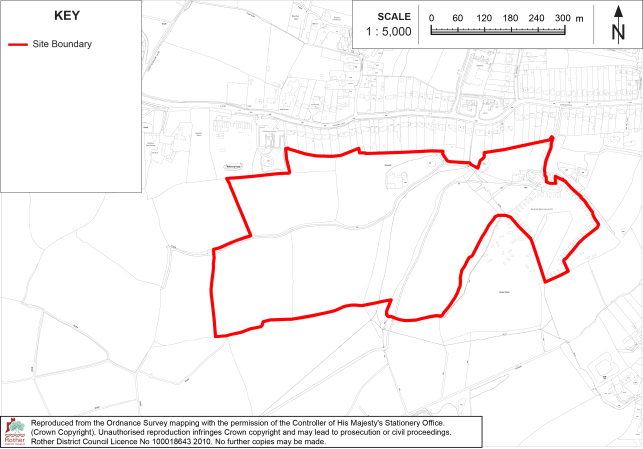
The site is allocated for a residential led, mixed-use development comprising:
- Some 400 dwellings;
- Employment uses (within Class E(g) or B8), or commercial uses which could include tourism uses/ accommodation;
- Community uses, including open space and potentially formal sports provision.
Development on this site must:
- Provide a policy-compliant amount of on-site affordable housing in line with policy HOU2 of the Rother Local Plan;
- Accord with Policy BX15 of this Plan (West Bexhill Growth Area – Infrastructure Policy) in terms of including direct provision of and/ or financial contributions towards all necessary infrastructure to serve the development along with development in the wider West Bexhill area;
- Comply with a whole-site masterplan, to be developed by the site promoter, to identify uses and areas for development, areas for green infrastructure, and vehicular, pedestrian and cycle links, in line with the West Bexhill Masterplan Framework. The masterplan should be informed by a landscape and visual impact assessment and a heritage assessment to determine an appropriate layout, form and detailed design to ensure the protection of the landscape and character of the Pevensey Levels to the south-west of the site, provide an appropriate settlement edge, and preserve and enhance heritage assets;
- Preserve and enhance the significance of the Grade II listed building, Barnhorne Manor, Lower Barnhorne, including its associated historic farmstead character;
- Include vehicular access(es) from Barnhorn Road to include necessary improvements and infrastructure to meet the requirements of National Highways;
- Include new pedestrian and cycle links within the site, linking to existing public rights of way and public highways outside the site, also retaining existing public footpaths within the site;
- Provide improvements to existing local bus stop infrastructure and a financial contribution towards improving local bus services;
- Include substantial areas of green infrastructure including public open space (including play-space and formal playing pitch(es), subject to demand) and areas for Biodiversity Net Gain across the site in accordance with the whole-site masterplan, also including appropriate buffers of semi-natural habitat adjacent to the ancient woodland;
- Retain and enhance all existing hedgerows, mature trees and areas of woodland within the site and on the site boundaries, except for any short sections of hedgerow which are required to be removed to facilitate access, which should be minimised as far as possible;
- Retain and protect existing ponds, streams and ditches within the site and provide an appropriate buffer to any built development including roadways;
- Be informed by a site-specific flood risk assessment and avoid development within Flood Zones 2 and 3 and areas at risk of surface water flooding;
- Incorporate appropriate SuDS with a minimum of three treatment stages in accordance with Policy ENV3, and be subject to Habitats Regulations Assessment screening to demonstrate beyond reasonable scientific doubt that these can be delivered on the site without harming the integrity of the Pevensey Levels Special Area of Conservation/RAMSAR site;
- Provide a connection to the local sewerage system at the nearest point of adequate capacity, in collaboration with the service provider;
- Phase the occupation of development to align with the delivery of sewerage infrastructure, in consultation with the service provider.
10.120This is a large area of mostly greenfield land to the south of Barnhorn Road, comprising agricultural fields at the rear of ribbon development. It also includes, in its eastern section, the Barnhorn Manor Caravan Park and a historic farmstead and Grade II listed building at Barnhorne Manor, Lower Barnhorne.
10.121The site is within the Live Well Locally Area Type, has a site size of 24 hectares and an indicative developable area of 12 hectares. It is allocated for some 400 dwellings as part of a mixed-use scheme at an indicative residential density of 40 dwellings per hectare.
10.122Development of this site will result in a relatively large extension of the built form of Bexhill into the countryside. However, a carefully designed development, suitably landscaped and including a mix of uses and improved pedestrian and cycle links, will enable the creation of a sustainable community with a new urban edge while protecting the adjoining sensitive landscape and heritage assets.
Landscape Impacts
10.123The proximity of the Levels, with its wide, open views south-westwards constrains the extent of developable land south of Barnhorn Road in landscape terms. Adjoining land to the west (in the same ownership) is considered unsuitable for development due to its exposure from the south-west, meaning development here would be very harmful to the landscape setting of Bexhill. The site itself, however, is relatively enclosed from wider views, containing individual fields benefiting from mature and substantial treed and hedged field boundaries, although development within the northern parts of the site in particular is likely to be visible in long views from lower lying land to the south, against the backdrop of existing ribbon development south of Barnhorn Road. Development proposals will need to be informed by a detailed Landscape and Visual Impact Assessment in accordance with Policy LAN1, to ensure development is landscape-led and creates a new, high-quality settlement edge.
10.124As well as including an appropriate buffer, the Ancient Woodland parcels to the east of the site should be provided with a linking woodland belt with scrub which would extend along the southern edge of the site, with a thinner tree belt along the northern edge. This will also provide some physical and visual separation with the Grade II Listed Barnhorne Manor Lower Barnhorne. All existing field boundaries and individual mature trees (including veteran trees and ancient woodland) within and adjoining the site will need to be retained and protected as part of the development, together with existing ponds, ditches and streams.
10.125The narrow central fields west of the Ancient Woodland (the westernmost of which contains a Public Footpath) should be left at least partly undeveloped, to form part of a GBI network, to conserve the rural character and perception of this from the Right of Way, with suitable buffers where required, including consideration of the present glimpsed visibility towards the southern elevation of the Grade II Listed Barnhorne Manor Lower Barnhorne. The historic agricultural structures north-west of these fields should be considered for retention in part, perhaps re-purposed or incorporated in some way to retain the time depth to non-designated heritage assets within the Site.
10.126The more cohesive group of fields to the west, which fall to the south towards the Pevensey Levels are defined within a strong structure of tree belts and lines of varying widths, which would physically and visually contain settlement, whilst reflecting a westerly extension of the Bexhill settlement boundary towards a strong western boundary tree belt, underscoring the existing ribbon development to north. Where vegetated boundaries are thinner there may be an opportunity to further reinforce these, which may contribute to enhanced ecological connectivity and reduced sediment runoff / potential improvement to water quality.
Heritage Impacts
10.127 The site is largely within an Archaeological Notification Area and contains a historic farmstead and Grade II listed building, Barnhorne Manor, Lower Barnhorne in its eastern section. Development of the site will need to take a whole-site masterplan approach, informed by a proportionate heritage assessment[4] which identifies the significance of Barnhorne Manor, defines the areas of land that contribute most strongly to its setting, and establishes clear parameters for layout, density, building height, landscape buffers, open space, access, movement and design character. The listed building’s architectural, historic, spatial and farmstead relationships are to be conserved as part of the development.
10.128Development in the eastern part of the site has the greatest potential to affect the setting and appreciation of the listed building. The principal approach drive, associated open land, former farmstead context, tree and hedgerow structure, and the spatial relationship between the manor and its surrounding rural landscape should be retained as legible components of the asset’s setting. a sensitive landscape-led strategy both in the immediate vicinity of Barnhorne Manor and across the wider allocation where this contributes to the experience of the listed building. Around the listed building, substantial open space, structural planting and retained field boundaries should be used to secure separation, preserve the primacy of the heritage asset and soften the transition between new development and the historic farmstead. At the same time, the treatment of the southern and south-western edges of the allocation will be important in longer views where those views contribute to the appreciation of Barnhorne Manor and its wider rural setting.
10.129 In design terms, the prevailing context indicates that a traditional character and form would be the most appropriate response within the vicinity of the manor house. New built form should be clearly subservient to Barnhorne Manor in scale, height, massing, roofscape, materials, boundary treatment and detailing, and should avoid a standard suburban character that would compete with, or visually absorb, the listed building. A varied density approach may therefore be required, with lower density, greater landscape separation and a more restrained architectural language around the manor and its approach, while any higher density elements are directed to less heritage-sensitive parts of the site.
Ecological and Water Impacts
10.130The site lies within the Pevensey Levels Hydrological Catchment and parts of the site directly adjoin the Pevensey Levels SSSI, SAC and Ramsar site. Habitats Regulations Assessment screening will be needed, to demonstrate beyond reasonable scientific doubt that the development can be delivered on the site without harming the integrity of the Pevensey Levels Special Area of Conservation/RAMSAR site. The protected habitats sites, together with the ancient woodland adjacent to the site’s south-eastern boundary, are identified as Areas of Particular Importance for Biodiversity (APIBs) in the Local Nature Recovery Strategy (LNRS), and adjoining areas (some within the site) are identified as Areas that Could Become of Importance to Biodiversity (ACIBs). Development will need to include significant areas for Biodiversity Net Gain, taking into account the Priorities and Measures of the LNRS.
10.131The whole site masterplan will need to include substantial areas of green infrastructure throughout the site, including areas of public open space. This will need to be carefully designed to encourage public use and not create additional recreational pressures on the Pevensey Levels or other areas of APIB or ACIB in close proximity to the site.
10.132Due to its location within the Pevensey Levels Hydrological Catchment, the proposal would need to include appropriate Sustainable Drainage (SuDS) with at least three treatment stages, in accordance with Policy ENV3. Early pre-application engagement with the Lead Local Flood Authority and the Pevensey and Cuckmere Water Level Management Board will be needed, together with a site-specific flood risk assessment. The extent of necessary SuDS features will inform the layout of the development and the overall site capacity. In addition, Southern Water has advised that the site may have limited local network (sewerage) capacity, and phasing of development may therefore be needed alongside network reinforcement prior to occupation of the total number of dwellings.
Access and Sustainable Transport
10.133Vehicular access to the site will need to come from the A259 Barnhorn Road to the north, which is part of the Strategic Road Network, however, a suitable access point has yet to be determined.
10.134Land adjacent to the site to the north-west has been made available, where a new roundabout could potentially be constructed on the A259. However, this would result in development in a highly prominent location when viewed from the Pevensey Levels to the south-west, harming the rural character of the edge of Bexhill and potentially also harming the setting of the Grade II Listed building Barnhorn Manor (Barnhorn Road). Consequently, an access further east would be preferable in landscape terms.
10.135Detailed transport assessment will need to be carried out to support the planning application, to determine the vehicular access point(s) and the extent of necessary improvements and interventions. This includes policy compliance regarding new accesses onto the Strategic Road Network as contained with DfT Circular 01/2022, in particular paragraphs 18 to 25. In addition, compliance will be required in line with the Design Manual for Roads and Bridges (DMRB) and a Stage 1 Road Safety Audit (RSA) and a Walking, Cycling and Horse-riding Assessment and Review (WCHAR) will need to be evidenced, all to be assessed by National Highways and East Sussex County Council.
10.136Improvements to the existing public rights of way network, as well as new pedestrian and cycle paths through the site and linking it to the district centre at Little Common and further south-east towards Cooden Beach station, will also be required, along with improvements to bus services.
Mix of Uses
10.137 The redevelopment of the caravan park within the site will result in the loss of tourist accommodation, contrary to Local Plan policy, and consequently, the site should accommodate either new employment floorspace or alternative, appropriate commercial uses (which could include tourist accommodation). The provision of a mix of uses, to also include community uses, significant areas of green infrastructure and outdoor sports infrastructure (as appropriate) will also ensure the creation of a sustainable community in this south-western part of Bexhill. Minimum floorspace requirements have not been set through the policy, to allow flexibility for the mix of uses and also provide for the detailed scheme to take account of the site’s landscape and heritage sensitivities and vehicular access implications.
Policy BX20: Land north of Rosewood Park Comment
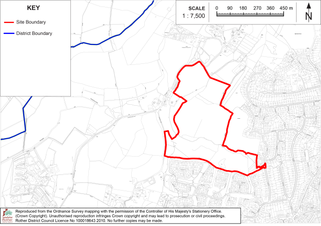
The site is allocated for a mixed-use development comprising:
- Some 340 dwellings;
- Retail and community facilities (Use Classes E/F) located centrally within the development, including a convenience retail element.
Development on this site must:
- Provide a policy-compliant amount of on-site affordable housing in line with policy HOU2 of the Rother Local Plan;
- Provide a centrally located retail/community facility (Use Classes E/F) including a convenience retail element;
- Provide areas of public open space, including formal and informal open space, a central focal area, children’s play space and green corridors.
- Provide new vehicular access from Stowe Drive via Brooklands Road and Barnhorn Road, with dedicated cycle lanes throughout the proposed main road network;
- Not include vehicular access from Sandhurst Lane (excepting emergency vehicles);
- Retain and enhance existing Public Rights of Way (PRoW) across the site and provide new recreational routes through areas of public open space to link with the wider countryside and PRoW network.
- Provide a Green Infrastructure network comprising retained habitats across the site, complemented by new landscaped areas of open space and sustainable drainage (SuDS);
- Incorporate Sustainable Drainage with a minimum of three treatment stages in accordance with Policy ENV3, and be subject to Habitats Regulations Assessment screening to demonstrate beyond reasonable scientific doubt that the development can proceed without adverse effect on the integrity of the Pevensey Levels SAC/Ramsar site;
- Provide off-site transport infrastructure improvements;
- Provide improvements to existing local bus stop infrastructure and financial contributions towards public transport services, including an additional flexibus service with a centrally located hub on-site;
- Provide a Travel Plan, with an associated auditing fee to promote sustainable travel choices, including cycling, walking, car sharing, and low/ultra-low emission vehicles;
- Provide a connection to the local sewerage system at the nearest point of adequate capacity, in collaboration with the service provider;
- Phase the occupation of development to align with the delivery of sewerage infrastructure, in consultation with the service provider.
10.138This is a large greenfield site on the western edge of Bexhill, adjoining a sizeable, recently completed residential development at Rosewood Park. It is subject to an outline planning application, delegated to approve subject to the completion of a Section 106 legal agreement, and the policy reflects the parameters of that accepted proposal.
10.139 The site is within the Live Well Locally Area Type, has a site size of 25 hectares and an indicative developable area of 18.9 hectares (9.7 hectares of which is for housing). It is allocated for some 340 dwellings as part of a mixed-use scheme at an indicative residential density of 35 dwellings per hectare.
10.140The site predominantly consists of agricultural fields, with boundaries defined by hedgerows, woodland shaws and mature trees. It lies within the Pevensey Levels Hydrological Catchment Area and is located 0.9 km from the Pevensey Levels Ramsar, SAC and SSSI. Parts of the site fall within Flood Zones 2 and 3 and are at risk of surface water flooding, necessitating careful management of flood risk and drainage. The proposal would need to include appropriate Sustainable Drainage (SuDS) with at least three treatment stages, in accordance with Policy ENV3. Early pre-application engagement with the Lead Local Flood Authority and the Pevensey and Cuckmere Water Level Management Board will be needed, together with a site-specific flood risk assessment. In addition, Southern Water has advised that the site may have limited local network (sewerage) capacity, and phasing of development may therefore be needed alongside network reinforcement prior to occupation of the total number of dwellings.
10.141The development will also need to incorporate substantial new areas of public open space, including formal and informal provision, a central focal area, green corridors, and dedicated children’s play areas (NEAP, LAP and Trim Trails). The creation of a Green Infrastructure (GI) network is central to the required layout, retaining habitats of woodland, scrub, shaws, hedgerows, trees and floodplain grazing marsh, complemented by new landscaping and Sustainable Drainage Systems (SuDS). Development must be supported by a landscape-led masterplan, ensuring an integrated approach that enhances biodiversity and supports habitat connectivity.
10.142The majority of the site area is identified, in the Local Nature Recovery Strategy (LNRS) as an Area that Could Become of Importance to Biodiversity (ACIB), and the designated ancient woodland adjacent to the eastern boundary is an Area of Particular Importance to Biodiversity (APIB). Development will need to include significant areas for Biodiversity Net Gain, taking into account the Priorities and Measures of the LNRS. Priority species, including White Admiral butterfly, are recorded adjacent to the site and ecological surveys will be required.
10.143The site is within the Pevensey Levels Hydrological Catchment, and Habitats Regulations Assessment screening will be required to demonstrate beyond reasonable scientific doubt that the development can proceed without adverse effects on the integrity of the Pevensey Levels SAC/Ramsar site. Early engagement with the Lead Local Flood Authority and the Pevensey and Cuckmere Water Level Management Board will be needed to ensure the provision of appropriate Sustainable Drainage (SuDS).
10.144The site also lies in an area of known archaeological interest and heritage investigations will be required in accordance with Policy HER1.
10.145Access will be taken from Stowe Drive via Brooklands Road and onto the A259/Barnhorn Road (part of the Strategic Road Network), supported by dedicated cycle lanes, improved public rights of way and new recreational links to the wider countryside. Any proposed upgrade/improvement of an existing SRN access will need to be fully assessed by National Highways in line with the relevant guidance set out in DfT Circular 01/2022 and the Design Manual for Roads and Bridges (DMRB). The development will also provide a centrally located retail/community facility (Use Classes E/F) including a convenience retail element to reduce the need for longer journeys.
10.146To mitigate transport impacts, a comprehensive package of highway and sustainable transport measures will be secured. This includes off-site works, financial contribution towards Footpath FP51b upgrade, investment in bus services and digital demand responsive transport (DDRT), and a centrally located transport hub with shelter, lighting and seating, a Travel Plan, and provision of electric vehicle hire car club spaces.
10.147Phasing of development is critical to ensure highway capacity and safety are maintained. Access arrangements, parking and cycle parking provision must be completed for each phase before its occupation.
Policy BX21: Land east of Sandhurst Lane Comment
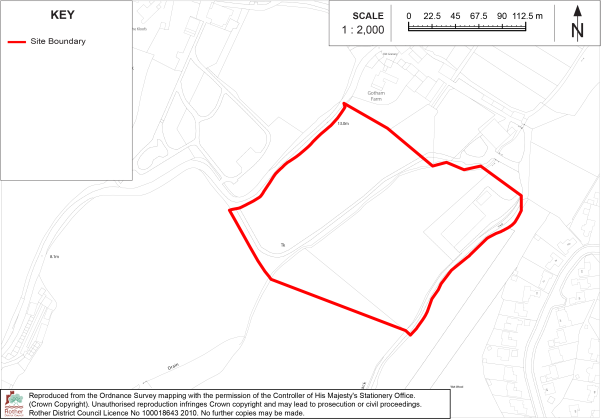
The site is allocated for residential development comprising some 68 dwellings.
Development on this site must:
- Provide a policy-compliant amount of on-site affordable housing in line with policy HOU2 of the Rother Local Plan;
- Be brought forward as part of, or following, the development of the adjacent site to the south, subject to allocation Policy BX20 of this Plan;
- Include vehicular access from the adjacent land to the south only, subject to site allocation Policy BX20 of this Plan, via Brooklands Road from the A259;
- Not include vehicular access from Sandhurst Lane;
- Link to and retain the public footpath (Bexhill 71) within the site;
- Incorporate Sustainable Drainage with a minimum of three treatment stages in accordance with Policy ENV3, and be subject to Habitats Regulations Assessment screening to demonstrate beyond reasonable scientific doubt that the development can proceed without adverse effect on the integrity of the Pevensey Levels SAC/Ramsar site;
- Protect the setting of the historic farmstead, Gotham Farm, to the north of the site;
- Be subject to a contaminated land assessment and incorporate any required mitigation and remediation measures and subsequent monitoring;
- Provide a connection to the local sewerage system at the nearest point of adequate capacity, in collaboration with the service provider;
- Phase the occupation of development to align with the delivery of sewerage infrastructure, in consultation with the service provider;
- Include areas of public open space and areas for Biodiversity Net Gain across the site in accordance with Local Plan policy;
- Include provision for the retention and future management of a buffer zone of semi-natural habitat, at least 15 metres wide, on the south-eastern boundary, between the edge of development and the ancient woodland;
- Include no built development in the parts of the site which are shown to be at risk of surface water flooding;
- Retain and enhance the existing hedgerows within the site and on-site boundaries.
10.148The site comprises sections of two agricultural fields and associated agricultural structures, just north of the larger area of land subject to site allocation policy BX20 of this Plan. It is within the Live Well Locally Area Type, has a site size of 3.3 hectares and an indicative developable area of 1.7 hectares. It is allocated for some 68 dwellings at an indicative residential density of 35 dwellings per hectare.
10.149The site is currently of a semi-rural character, however the character of the area will change significantly with the development of site BX20, and this site provides an opportunity to extend the residential development agreed on the larger site, using the same vehicular access, but will only be acceptable if constructed at the same time as, or following, the development of site BX20. A Landscape and Visual Impact Assessment will be required to inform the layout and detailed design of the development and an area of green infrastructure will be required in the northern section of the site to provide appropriate separation to, and protect the setting of the historic farmstead to the north.
10.150Policy criteria are included to address the environmental and heritage constraints affecting the site including Ancient Woodland, an historic farmstead and a Public Right of Way. There are also areas of the site at risk of surface water flooding, and these are primarily located in the areas of existing development and the track through the centre of the site.
10.151The whole site area is identified, in the Local Nature Recovery Strategy (LNRS) as an Area that Could Become of Importance to Biodiversity (ACIB), and the designated ancient woodland adjacent to the eastern boundary is an Area of Particular Importance to Biodiversity (APIB). Development will need to include significant areas for Biodiversity Net Gain, taking into account the Priorities and Measures of the LNRS. Priority species, including White Admiral butterfly, are recorded adjacent to the site and ecological surveys will be required to accompany the planning application.
10.152The site is within the Pevensey Levels Hydrological Catchment, and Habitats Regulations Assessment screening will be required to demonstrate beyond reasonable scientific doubt that the development can proceed without adverse effects on the integrity of the Pevensey Levels SAC/Ramsar site, with SUDS including at least three treatment stages in line with Policy ENV3. Early engagement with the Lead Local Flood Authority and the Pevensey and Cuckmere Water Level Management Board will be needed to ensure the provision of appropriate Sustainable Drainage (SuDS).
10.15310.153 The site is not particularly well-located in relation to services and facilities in Little Common and Bexhill. Additionally, vehicular access from the adjoining road, Sandhurst Lane, would not be appropriate due to the narrow and winding nature of that lane.
10.154 As noted above, the acceptability of the development of this site is dependent on the development of the adjoining site (BX20) – to provide both a vehicular access but also some mix of facilities and services in close proximity, namely, the retail/community facility (Use Classes E/F) and sustainable transport hub within the larger site. The site will therefore ultimately gain access form the A259/Barnhorn Road which is part of the Strategic Road Network. Any proposed upgrade/improvement of an existing SRN access will need to be fully assessed by National Highways in line with the relevant guidance set out in DfT Circular 01/2022 and the Design Manual for Roads and Bridges (DMRB).
Policy BX22: Land at Barnhorn Green Comment
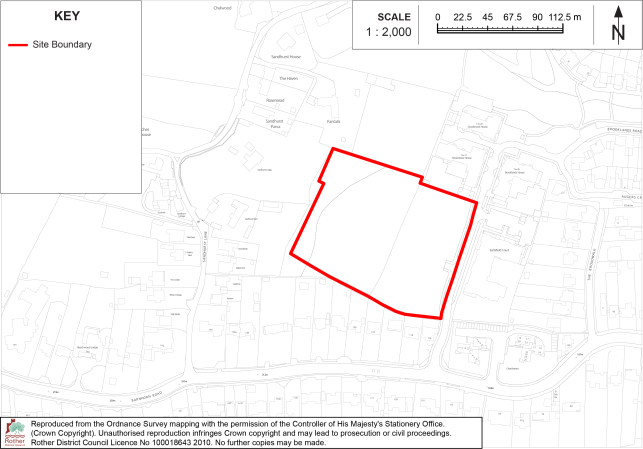
The site is allocated for a mixed-use development comprising:
- a medical centre; and
- some 2,025 sqm employment floorspace (Use Class E(g) or B8); or
- employment floorspace and small-scale residential units (circa 5-10 dwellings).
Development on this site must:
- Include access from Brooklands Road;
- Include a Travel Plan to promote sustainable transport modes, including walking, cycling, public transport, car sharing, and low emission vehicles;
- Secure biodiversity net gain through habitat creation, ecological enhancements, and long-term management;
- Ensure the protection of protected species using the site;
- Deliver a sensitive lighting strategy to avoid impacts on protected species and neighbouring amenity;
- Be subject to Habitats Regulations Assessment screening and incorporate necessary mitigation to ensure no adverse effect on the integrity of the Pevensey Levels, including appropriate Sustainable Drainage (SuDS) with at least three treatment stages, in accordance with Policy ENV3;
- Provide improvements to existing local bus stop infrastructure and contribute financially towards improving local bus services;
- Provide for access through to the adjoining land to the north, subject to site allocation policy BX23 of this Plan.
10.155This site lies within the wider Rosewood Park development area, north of the A259. It is currently grassed with mature hedgerows and trees, including a north–south tree belt of landscape importance.
10.156The Council acquired the site in 2019 to ensure delivery of employment space and a GP surgery. Planning permission has since been granted which includes modern light industrial units, meeting a clear local need for small workshops. As development has not yet commenced, the site allocation policy reflects the planning permission in parts (a) and (b). The policy also provides flexibility for an alternative mixed use to include small-scale residential units, in the event of the employment floorspace not coming forward[5], which is appropriate given the residential character of the surrounding area and the small amount of potential employment floorspace affected.
10.157The site will also deliver a new medical centre to meet growing primary care needs. The existing Little Common Surgery is constrained and lacks capacity to expand. In partnership with the NHS and local GPs, the Council has developed a purpose-built facility to accommodate the Primary Care Network, provide additional clinical services, improve accessibility, and meet modern parking requirements. The centre will be delivered to Health Building Note standards and achieve BREEAM Excellent in line with funding requirements.
10.158The site access is from the A259, part of the Strategic Road Network. Any proposed upgrade/improvement of an existing SRN access will need to be fully assessed by National Highways in line with the relevant guidance set out in DfT Circular 01/2022 and the Design Manual for Roads and Bridges. The site adjoins existing residential areas and community facilities, with Little Common local centre within walking and cycling distance, offering shops and services for future employees.
10.159Ecological assessment has identified habitats and species of value, which will need to be safeguarded and enhanced through appropriate mitigation and biodiversity measures. Development will need to ensure integration with its surroundings and a cohesive design approach across the whole site.
10.160The site is within the Pevensey Levels Hydrological Catchment, and Habitats Regulations Assessment screening will be required to demonstrate beyond reasonable scientific doubt that the development can proceed without adverse effects on the integrity of the Pevensey Levels SAC/Ramsar site, with SUDS including at least three treatment stages in line with Policy ENV3. Early engagement with the Lead Local Flood Authority and the Pevensey and Cuckmere Water Level Management Board will be needed to ensure the provision of appropriate Sustainable Drainage (SuDS).
Policy BX23: Land south of Sandhurst Lane, Bexhill Comment
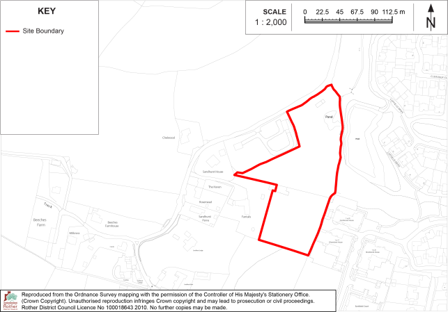
The site is allocated for residential development comprising some 25 dwellings.
Development on this site must:
- Provide a policy-compliant amount of on-site affordable housing in line with policy HOU2 of the Rother Local Plan;
- Include vehicular access from Brooklands Road via the adjoining land to the south which is subject to site allocation Policy BX22 of this Plan;
- Not include vehicular access to Sandhurst Lane;
- Retain and enhance the existing hedgerows, trees (including protected trees) and woodland within the site and on the site boundaries;
- Retain and protect the existing pond in the north-eastern part of the site, and the pond on adjoining land to the east, and provide an appropriate buffer to any built development including roadways;
- Include no built development in the parts of the site which are shown to be at risk of surface water flooding;
- Be subject to Habitats Regulations Assessment screening and incorporate necessary mitigation to ensure no adverse effect on the integrity of the Pevensey Levels, including appropriate Sustainable Drainage (SuDS) with at least three treatment stages, in accordance with Policy ENV3.
10.161 This is a contained site comprising two land parcels, which is adjacent to existing and planned built development. It provides an opportunity for additional dwellings. It is within the Live Well Locally Area Type, has a site size of 1.45 hectares and an indicative developable area of 0.7 hectares. It is allocated for some 25 dwellings at an indicative residential density of 40 dwellings per hectare.
10.162 While the site bounds Sandhurst Lane to the north, this would not provide an acceptable vehicular access to the site due to its narrow and winding nature and lack of footways. Consequently, vehicular access must come from adjoining land to the south (subject to Policy BX23 of this Plan). This means access will be ultimately come via the A259 Barnhorn Road which is part of the Strategic Road Network (SRN). Any proposed upgrade/improvement of an existing SRN access will need to be fully assessed by National Highways in line with the relevant guidance set out in DfT Circular 01/2022 and the Design Manual for Roads and Bridges (DMRB).
10.163The northern part of the site is more environmentally constrained than the southern section, containing mature trees (including protected trees on its eastern boundary), a pond within its eastern section and a further large pond on adjoining land. This part of the site also gives rise to areas at risk of surface water flooding. This part of the site offers opportunities for Biodiversity Net Gain.
10.164The site lies within the Pevensey Levels Hydrological Catchment Area, meaning that development must incorporate careful sustainable drainage (SuDS) solutions comprising at least three treatment stages in accordance with Policy ENV3. Early engagement with the Lead Local Flood Authority and the Pevensey and Cuckmere Water Level Management Board will be needed to ensure the provision of appropriate Sustainable Drainage (SuDS).
Policy BX24: Beeches Farm and land north of Barnhorn Road Comment
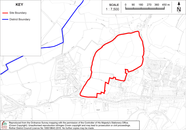
The site is allocated for residential-led mixed use development comprising:
- Some 540 new dwellings;
- A new one-form entry primary school with Early Years nursery provision;
- Small-scale class E units, to accommodate, for example, a local shop and/ or small-scale workshops or light industrial uses;
- Community uses, including open space and potentially formal outdoor sports provision.
Development on this site must:
- Provide a policy-compliant amount of on-site affordable housing in line with policy HOU2 of the Rother Local Plan;
- Accord with Policy BX15 of this Plan (West Bexhill Growth Area – Infrastructure Policy) in terms of including direct provision of and/ or financial contributions towards all necessary infrastructure to serve the development along with development in the wider West Bexhill area;
- Comply with a whole-site masterplan, to be developed by the site promoter, to identify uses and areas for development, areas for green infrastructure, and vehicular, pedestrian and cycle links, in line with the West Bexhill Masterplan Framework. The masterplan should be informed by a landscape and visual impact assessment and a heritage assessment to determine an appropriate layout, form and detailed design to ensure the protection of the landscape and character of the countryside to the north and north-east of the site, provide an appropriate settlement edge, and preserve and enhance heritage assets;
- Include vehicular access from Barnhorn Road to include necessary improvements and infrastructure to meet the requirements of National Highways;
- Not include vehicular access from Sandhurst Lane or Coneyburrow Lane;
- Include new pedestrian and cycle links within the site, linking to existing public rights of way and public highways outside the site, also retaining existing public footpaths within the site;
- Provide improvements to existing local bus stop infrastructure and make financial contributions towards improving local bus services;
- Provide improvements to existing active travel infrastructure between the site and Little Common District Centre;
- Include substantial areas of public open space (including play-space and formal playing pitch(es), subject to demand) and areas for Biodiversity Net Gain across the site in accordance with Local Plan policy;
- Retain and enhance existing hedgerows, field boundaries and mature trees within the site and on the site boundaries, except for any short sections of hedgerow which are required to be removed to facilitate access, which should be minimised as far as possible;
- Incorporate appropriate SuDS with at least three treatment stages in accordance with Policy ENV3 and be subject to Habitats Regulations Assessment screening to demonstrate beyond reasonable scientific doubt that these can be delivered on the site without harming the integrity of the Pevensey Levels Special Area of Conservation/RAMSAR site;
- Preserve or enhance the significance of the Grade II Listed Buildings, Beeches Farm and Sandhurst Lodge, to the east of the site;
- Provide a connection to the local sewerage system at the nearest point of adequate capacity, in collaboration with the service provider;
- Phase the occupation of development to align with the delivery of sewerage infrastructure, in consultation with the service provider.
10.165This is a large greenfield site on the northern side of Barnhorn Road (A259), comprising a network of agricultural fields, with mature trees and hedges defining individual field boundaries. It is within the Live Well Locally Area Type, has a site size of 29.7 hectares and an indicative developable area of 15 hectares. It is allocated for some 540 dwellings at an indicative residential density of 40 dwellings per hectare as part of a mixed-use development.
10.166The site provides an opportunity for a strategic-scale, residential-led, mixed-use development on the edge of Bexhill. Unlike many development sites in this area, the site has a direct frontage to Barnhorn Road and consequently, is also suitable to a primary school and class E uses required through Policy BX15 of this Plan (West Bexhill Growth Area – Infrastructure Policy). The site is also bound by Coneyburrow Lane and Sandhurst Lane although these are not suitable to provide vehicular access to the site due to their narrow and winding nature and lack of footways.
Landscape Impacts
10.167This is an undulating site and while much of it is relatively contained in the landscape by its topography, there are some higher sections affording long views across the countryside to the north and north-west. Consequently, development will need to be carefully and sensitively designed, informed by a Landscape and Visual Impact Assessment and Heritage Assessment, to ensure an appropriate extension to the built form of Bexhill can be achieved without harming the intrinsic character and beauty of the countryside beyond.
10.168A key requirement to achieving a successful design will be the retention of existing field boundaries, including mature trees which are key landscape and ecological features. Coneyburrow Lane and Sandhurst Lane along the borders of the site are oak tree lined, with understorey scrub of varying densities. Field boundaries of more irregular field parcels to the northern half of the site are well defined with dense hedgerow and dispersed trees or tree lined. There are some field corner patches of woodland within the site. All trees and hedgerows should be retained as part of the development, excepting for short stretches to allow for access, which should be minimised as far as possible.
10.169The site comprises of a patchwork of some thirteen fields located about a spur of high ground, bordered by Coneyburrow Lane to the west, Sandhurst Lane to the east and Barnhorn Road (A259) to the south. Landform falls away east and west of the site and to the north, where the narrow country lanes form a junction, with Sandhurst Lane continuing northwards. Outside of the site area to the southeast is a cluster of dwellings including two Grade II Listed Buildings at Sandhurst Lodge and Beeches Farm, whose northern curtilage borders the Site. Public Footpath 12b extends between the two lanes upon the high ground west of Beeches Farm. There are views across to comparably elevated landform some 1km to the north and northwest from the Footpath. The southern fields within the Site upon the ridgetop contribute to the rural approach to Bexhill along the A259.
10.170Built development should be confined to the eastern and central parts of the site, which are more enclosed and do not readily form part of a treed skyline, meaning they are of lower susceptibility to change with regards to visual prominence and contribution to rural character. However, part of the eastern section of the site has heritage constraints, being located close to the two buildings as detailed further below, meaning a careful layout will be required. Built development should be avoided in the northern- and western-most fields in order to maintain rural vistas through the western part of the site from Barnhorn Road and provide a transition to the countryside beyond. The western and northern parts of the site could be suitable to accommodate green infrastructure including public open space, areas for habitat creation and SuDS features.
Heritage Impacts
10.171As noted above, there are two, 18th century, grade II listed buildings to the east of the site. The significance of both assets is partly architectural but also derives from their historic relationship with the surrounding agricultural and lane-side landscape, where their rural setting, mature boundary structure and separation from larger-scale built development contribute to an appreciation of their former functional and spatial context.
10.172Development has the potential to alter the rural and agricultural character of their setting, particularly on the eastern edge of the allocation and in views from Sandhurst Lane and surrounding public routes. The layout should be informed by a proportionate heritage assessment[6] that identifies the contribution made by the intervening fields, hedgerows, mature trees, lanes and topography to the significance of the listed buildings. Built development should be set back from the eastern boundary where necessary, with lower density, generous green infrastructure, retained and reinforced field boundaries, and carefully managed open space used to maintain a legible transition between the historic lane-side assets and the new development.
10.173The indicative density of 40 dwellings per hectare should not be applied uniformly where this would result in an abrupt suburban edge near the listed buildings or in elevated parts of the site that are more visible in views relevant to their setting. A varied density approach would be more appropriate, with more sensitive parts of the eastern and north-eastern edges designed at a lower intensity and with a stronger landscape framework. Any larger-footprint non-residential buildings, parking, servicing and lighting should be sited so that they do not introduce an overly urbanising influence within the setting of Sandhurst Lodge or Beeches Farm.
Ecological and Water Impacts
10.174Other than its significant treed boundaries detailed above, the site is relatively unconstrained, environmentally, although it lies within the Pevensey Levels Hydrological Catchment Area, meaning that development must incorporate careful sustainable drainage (SuDS) solutions comprising at least three treatment stages in accordance with Policy ENV3. Early engagement with the Lead Local Flood Authority and the Pevensey and Cuckmere Water Level Management Board will be needed to ensure the provision of appropriate Sustainable Drainage (SuDS). Parts of the site are at risk of flooding and development should be avoided in these areas.
Access and Sustainable Transport
10.175The site is some distance to services and facilities in Little Common District Centre, and not within walking distance of the nearest primary school. Consequently, the allocation includes provision for a primary school. This would be provided at the relevant time when the County Council determines there is a need for additional school places. Consequently, the policy also requires a raft of sustainable transport measures including improvements to bus services and active travel routes outside the site (linking to Little Common) and also active travel routes through the site. Contributions towards improving connectivity with the nearest railway station at Cooden Beach may also be appropriate.
10.176Evidence suggests that an acceptable vehicular access onto the A259 is achievable. Vehicular access to the site via the two adjacent lanes, Coneyburrow Lane and Sandhurst Lane, will not be permitted (other than any necessary emergency access) due to the narrow and winding nature of the lanes. However active travel linkages and improvements will be required. Detailed transport assessment at planning application stage will be required to determine the requirement for improvements and interventions on the A259, to be assessed by National Highways. This includes policy compliance regarding new accesses onto the Strategic Road Network as contained with DfT Circular 01/2022, in particular paragraphs 18 to 25. In addition, compliance will be required in line with the Design Manual for Roads and Bridges and a Stage 1 Road Safety Audit (RSA) and a Walking, Cycling and Horse-riding Assessment and Review (WCHAR) will need to be evidenced.
Mix of Uses
10.177 A mix of uses will be required within the site to provide for services and facilities in walking distance of new dwellings. This will include a primary school when required, but in the shorter term, small-scale class E units, to accommodate, for example, a local shop and/ or small-scale workshops or light industrial uses, and community uses, including open space and potentially, formal outdoor sports provision.
Policy BX25: Land at Northeye and adjoining land Comment
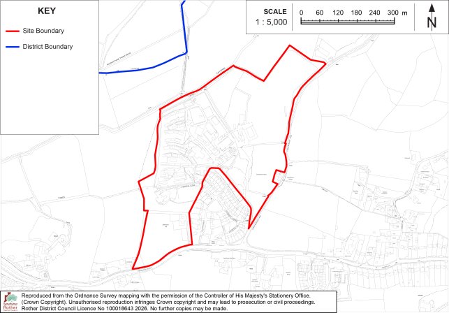
The site is allocated for a residential-led mixed use development comprising:
- some 364 dwellings;
- community uses which could include outdoor sports facilities including formal playing pitch(es).
Development on this site must:
- Provide a policy-compliant amount of on-site affordable housing in line with policy HOU2 of the Rother Local Plan;
- Accord with Policy BX15 of this Plan (West Bexhill Growth Area – Infrastructure Policy) in terms of including direct provision of and/ or financial contributions towards all necessary infrastructure to serve the development along with development in the wider West Bexhill area;
- Be informed by a landscape and visual impact assessment to determine an appropriate layout, form and detailed design and provide an appropriate settlement edge;
- Include vehicular access from Barnhorn Road or Wartling Drive to include necessary improvements and infrastructure to meet the requirements of National Highways and East Sussex County Council;
- Include new pedestrian and cycle links within the site, linking to existing public rights of way and public highways outside the site;
- Provide improvements to existing local bus stop infrastructure and make financial contribution towards improving local bus services;
- Include areas of public open space including play space and areas for Biodiversity Net Gain across the site in accordance with Local Plan policy;
- Include community uses including formal playing pitch(es) alongside ancillary changing and parking facilities, unless proposals are included to provide such pitches at an alternative off-site location;
- Retain and enhance the existing hedgerows, trees and field boundaries within the site and on the site boundaries;
- Retain and protect existing streams and ditches within the site and provide an appropriate buffer to any built development including roadways;
- Include a contaminated land survey in accordance with Policy ENV5 which fully investigates, and where necessary, remediates any contamination within the site;
- Incorporate the recommendations of the Level 2 Strategic Flood Risk Assessment, including a site-specific flood risk assessment which demonstrates that the development will be safe for its lifetime, taking account of the vulnerability of its users, without increasing flood risk elsewhere, and where possible, will reduce flood risk overall, avoiding built development in the north-western part of the site which is shown to be at risk of flooding;
- Incorporate appropriate SuDS with at least three stages of treatment in accordance with Policy ENV3 and be subject to Habitats Regulations Assessment screening to demonstrate beyond reasonable scientific doubt that the development can be delivered on the site without harming the integrity of the Pevensey Levels Special Area of Conservation/RAMSAR site;
- Include an assessment and evaluation of the site’s archaeological potential and the implementation of any mitigation measures identified through the assessment;
- Provide a connection to the local sewerage system at the nearest point of adequate capacity, in collaboration with the service provider;
- Phase the occupation of development to align with the delivery of sewerage infrastructure, in consultation with the service provider.
10.178The site comprises three separate land parcels. The largest parcel is brownfield, originally developed in the 1940s as a RAF base and later used as a prison and training centre, although it has been vacant for some years. Two adjoining parcels, comprising agricultural fields in separate ownership, are also available. Together, the three parcels provide an opportunity for a substantial residential development on the edge of Bexhill, to form part of a Live Well Locally sustainable community.
10.179The site measures some 19.2 hectares and has an indicative developable area of 9.5 hectares. It is allocated for some 364 dwellings at an indicative residential density of 40 dwellings per hectare.
10.180 The largest portion of the site was allocated for 140 dwellings and a full-sized adult football pitch and/ or a senior cricket pitch, with associated ancillary changing and parking facilities to serve the playing pitch, through the previous Local Plan. It was anticipated that the sports pitch would be provided on the level, northern section of the Northeye site. However, the current landowner (Homes England) has indicated that in order to make residential redevelopment of the site viable, additional housing will be required (above the 140 previously anticipated) and it will not be possible to accommodate a sports pitch.
10.181It is appreciated that the redevelopment of this likely contaminated, brownfield site will be costly. However, there remains a need for additional outdoor sports provision including formal playing pitches in Bexhill, as identified in the Rother and Hastings Playing Pitch and Built Facilities Strategy (2023), to meet the needs of new and existing residents. Identifying an alternative site for a sports pitch in the west Bexhill area is not straightforward, given the undulating topography of much of the area, the landscape and ecological sensitivities of the Pevensey Levels, and limitations to available land. The level topography of part of the Northeye site means that it likely remains the most suitable site. The Council will continue to work with the landowner to seek to secure both the delivery of housing at this site but also, ideally, the provision of a pitch and associated facilities. The addition of the two additional land parcels does provide an opportunity for additional dwellings, public open space and other community facilities within the wider site.
10.182The site, particularly the largest portion, is environmentally sensitive, containing Priority Habitat (Coastal and floodplain grazing marsh) in its north-western section, a habitat which links to the protected Pevensey Levels further west, and this section also lies within Flood Zone 3. This is also identified as an Area that Could be of Importance to Biodiversity (ACIB) in the Local Nature Recovery Strategy. Development will need to be informed by ecological surveys and include mitigation and enhancement measures, taking into account the Priorities and Measures of the LNRS.
10.183The site is undulating, including the two smaller land parcels, and sites on the edge of the marsh, with long views afforded north and westwards across the countryside. Development will need to be carefully designed to conserve Priority Habitats and avoid areas at risk of flooding but also to ensure an appropriate extension to the built form of Bexhill can be achieved without harming the intrinsic character and beauty of the countryside beyond. Trees and areas of scrub within the site and on the site boundaries should be retained, and development should be of high quality and landscape led.
10.184Public Footpath 59a which passes along the northern edge of the site could potentially be permanently diverted to its historic south-easterly alignment, through the site to a more southerly point along Coneyburrow Lane, as indicated on historic maps from the late 19th century, as part of the development.
10.185The whole site lies within the Pevensey Levels Hydrological Catchment Area and the policy requirements reflect this. Early engagement with the Lead Local Flood Authority and the Pevensey and Cuckmere Water Level Management Board will be needed to ensure the provision of appropriate Sustainable Drainage (SuDS) in accordance with Policy ENV3. This site also lies adjacent to a Main River (GB107041012430 - East Stream) and flood defences. Development will need to incorporate recommendations from the Level 2 Strategic Flood Risk Assessment, as follows:
- Demonstrate through a site-specific FRA that the proposed development will be safe for its lifetime, taking account of the vulnerability of its users.
- Blockage modelling should be conducted as part of an FRA to assess the residual risk associated with potential blockage of the road bridge within the site.
- A sequential approach should be undertaken, by locating the most vulnerable aspects of development in areas of lowest flood risk.
- Utilise SuDS with multiple benefits throughout the site, particularly in areas of predicted surface water risk.
- Detailed modelling of the ordinary watercourse which flows through the centre of the site should be undertaken.
- A buffer distance from the Main River and Ordinary Watercourse (at least 8m) will need to be maintained to allow access and maintenance.
10.186The southern part of the site is within an Archaeological Notification Area and a Heritage Assessment will be required in accordance with Policy HER1.
10.187Like for other sites in this area, detailed transport assessment will be required to determine the extent of impacts on the A259 trunk road/Strategic Road Network (SRN) and the requirement for improvements and interventions. There will be a need to comply with any requirements from National Highways, in addition to any from the Local Highway Authority. Any proposed upgrade/improvement of an existing SRN access will need to be fully assessed by National Highways in line with the relevant guidance set out in DfT Circular 01/2022 and the Design Manual for Roads and Bridges (DMRB).
10.188A mix of uses will be required within the site and the wider West Bexhill area, to provide for services and facilities in walking distance of new dwellings. Improvements to the existing public rights of way network as well as new pedestrian and cycle paths through the site and linking it to the district centre at Little Common will also be required, along with any necessary improvements to public transport provision and infrastructure.
North Bexhill Growth Area
Parish: Bexhill
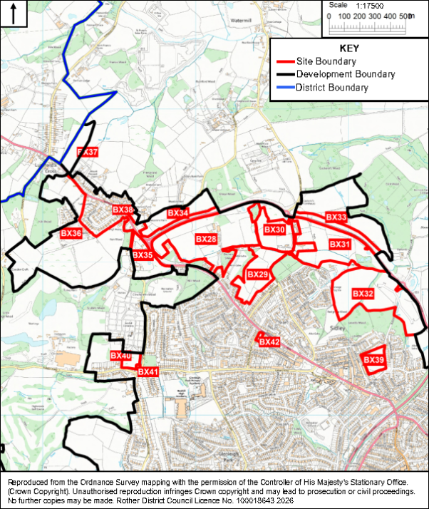
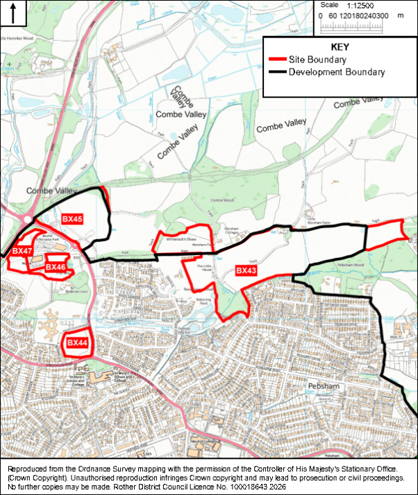
10.189The North Bexhill Growth Area encompasses a wide area of land stretching from the district’s border with Wealden in the west, towards the Strategic Gap between Rother and Hastings in the east. It includes many sites that have previously been subject to site allocations and/or have extant or expired planning permissions, together with some new, largely greenfield, site allocations.
10.190The North Bexhill Growth Area builds on the major urban extension at North East Bexhill, originally planned for in the 2006 Rother Local Plan, guided by a Supplementary Planning Document (2009) and taken forward as site allocations in the DaSA Local Plan (2019). This has now, in part, come forward. Sites within this Local Plan goes beyond the boundary of the original urban extension to take advantage of land now made accessible through the construction of new roads, and land now available to the west of Ninfield Road.
10.191North Bexhill is generally less environmentally constrained than West Bexhill, however, there are important features that must be protected, and improvements that are required. As well as meeting the needs of existing and new residents, some of the infrastructure requirements arise due to these characteristics, including:
- Impacts on the local road network, including on links to the wider strategic road network and key junctions, as well as narrow, winding country lanes in the north-west of Bexhill;
- The distance of many large sites from services, facilities and public transport connections in Sidley and Bexhill, meaning that without careful planning and provision of infrastructure, new residential development in the North Bexhill area could be unsustainable and largely car-dependent;
- A lack of attractive walking and cycling routes towards Sidley and Bexhill;
- Relative deprivation in the Sidley area;
- The proximity of some greenfield sites to the Strategic Gap between Bexhill, Crowhurst, St Leonards and Battle, and the landscape impact of new development at the edge of the urban area;
- The proximity of the Combe Valley Countryside Park, a strategic area of open space that serves Bexhill and Hastings.
Policy BX26: North Bexhill Growth Area - Infrastructure Comment
- New development within the North Bexhill Growth Area must appropriately contribute to the infrastructure required to create a sustainable, “Live Well Locally” community that also meets the Local Plan’s overall priorities of being “Green to the Core” and creating “A Thriving Local Economy”.
- Infrastructure will be required to be provided in a timely manner, either by direct provision or through proportionate (to the respective quantum of residential development) financial contributions attached to the respective planning permissions.
- The development of sites which are the subject of policies BX28, BX29, BX30, BX31, BX32, BX33, BX34, BX35, BX36, BX37, BX38 and BX45 shall contribute to shared infrastructure to serve those sites through:
- Improvements to the strategic and local road networks (including any improvements to the wider road network in the Bexhill area) that are necessary to make the impacts of development acceptable, in accordance with the requirements of National Highways and the Highway Authority;
- Improvements to pedestrian and cycling infrastructure to support and enable active travel, including new and improved safe and attractive routes to Sidley District Centre and Bexhill Town Centre including Bexhill railway station;
- Improvements to public transport including in terms of its provision and infrastructure, including financial contributions towards establishing a new bus service along Haven Brook Avenue;
- The provision of a new Primary School with Early Years Nursery provision, to serve the North Bexhill Area, when required by the Education Authority;
- A comprehensive network of Green and Blue Infrastructure, including attractive and landscaped public open spaces with retained mature trees and ponds, play areas for all ages, and areas for habitat creation and biodiversity enhancements, having regard to the qualitative and quantitative deficits identified by the Rother Green and Blue Infrastructure Study (2026) and the Measures and Priorities identified in the Local Nature Recovery Strategy;
- The provision of outdoor sports facilities including formal playing pitches (which may be all-weather pitches) to meet the needs of new residents, with appropriate supporting infrastructure;
- The provision of indoor meeting places within sites BX33 and BX36;
- Incorporation of appropriate Sustainable Drainage Systems (SuDS) in accordance with Policy ENV3 and, where necessary, with development subject to Habitats Regulations Assessment screening to demonstrate beyond reasonable scientific doubt that development can be delivered on the site without harming the integrity of the Pevensey Levels Special Area of Conservation/RAMSAR site (the western part of the Growth Area lies within the Pevensey Levels Hydrological Catchment);
- The provision of an overarching foul drainage strategy, in conjunction with Southern Water. Occupation of development to be phased to align with the delivery of sewerage infrastructure, in consultation with the service provider.
10.192There is a need for a master-planning approach to the North Bexhill Growth Area to ensure the creation of a Live Well Locally sustainable community. A strategic masterplan diagram is shown at Figure 10.4 below.
10.193The North Bexhill Strategic Masterplan provides an overarching spatial framework for coordinating development across the Growth Area and integrating new development with existing neighbourhoods and infrastructure. It identifies the broad relationship between development areas, employment land, local shops and services, education, health and community infrastructure, sports and recreation, strategic green and open space, retained woodland and other landscape features, key heritage assets, principal development accesses, public transport corridors and strategic active travel connections. The strategic active travel network identifies existing and planned routes, connections to be incorporated within development and network gaps that need to be addressed as sites come forward.
10.194Haven Brook Avenue and Ninfield Road will form important movement and public transport corridors through the Growth Area and should develop as integrated streets within the new neighbourhoods rather than as barriers between development areas. Development adjoining these routes should therefore positively address them through active, well-overlooked frontages, avoiding layouts dominated by rear garden boundaries, blank elevations or parking.
10.195The masterplan is strategic and indicative rather than a detailed design or layout for individual sites. Development proposals should respond positively to the spatial principles shown and contribute to a coherent Growth Area rather than coming forward as isolated developments. Particular importance should be given to connecting streets and active travel routes across site boundaries and with existing neighbourhoods, closing identified gaps in the strategic active travel network, integrating and connecting green and blue infrastructure, and ensuring that local shops and services, health and community facilities, the proposed primary school, sports and recreation provision and other infrastructure are accessible to existing and new communities by walking, wheeling, cycling and public transport. The precise layout and form of development will be determined through the relevant site allocation policies, other policies of the Local Plan and, where required, more detailed site masterplanning.
10.196New residential and employment development must be supported by new and improved infrastructure. This is identified in the Infrastructure Delivery Plan (IDP) and Policy BX26. The IDP will be subject to regular review, ensuring it takes account of the latest available information including on development phasing and viability. Impacts on infrastructure in adjoining Authorities is also a consideration, given the close proximity of parts of the Growth Area to the district boundary.
10.197It is appreciated that some of the individual sites listed in Policy BX26 already benefit from planning permission (or are delegated to approve subject to a Section 106 agreement). In these cases, the infrastructure requirements of the individual site would have been secured through the permission, and this policy does not change that. However, the sites are included to allow for a situation where an existing planning permission may not be implemented.
North Bexhill Growth Area – Strategic Masterplan Comment
Strategic Masterplan Key:
|
Development: |
Green & Open Space: |
||
|
Growth Area Boundary |
Ancient Woodland |
||
|
Development Area |
Woodland, Tree Belts & Hedgerows |
||
|
Local Shops & Services |
Open Space / Green Infrastructure |
||
|
Proposed Local Shops and Services |
Sports & Recreation |
||
|
Existing Primary School |
Proposed Sports and Recreation |
||
|
Existing Secondary School |
Listed Buildings |
||
|
Potential Location for a Primary School |
District Boundary |
||
|
Employment Area |
|||
|
Transport Infrastructure: |
Health & Community: |
||
|
Existing Bus Route |
Existing GP / Health Facility |
||
|
Existing Bus Stop |
Proposed GP / Health Facility |
||
|
Proposed / Enhanced Public Transport Corridor |
Existing Community Facility |
||
|
Principal Development Access |
Proposed Community Facility |
||
|
Strategic Active Travel Network: |
|||
|
PROW - Public Right-of-Way & Existing Strategic Active Travel Route |
|||
|
Proposed upgrade of Strategic Active Travel Route |
|||
|
LCWIP Route / Planned Active Travel Improvement |
|||
|
Strategic Active Travel Connection to be Incorporated Within Development |
|||
|
Strategic Network Gap / Connection Required |
|||
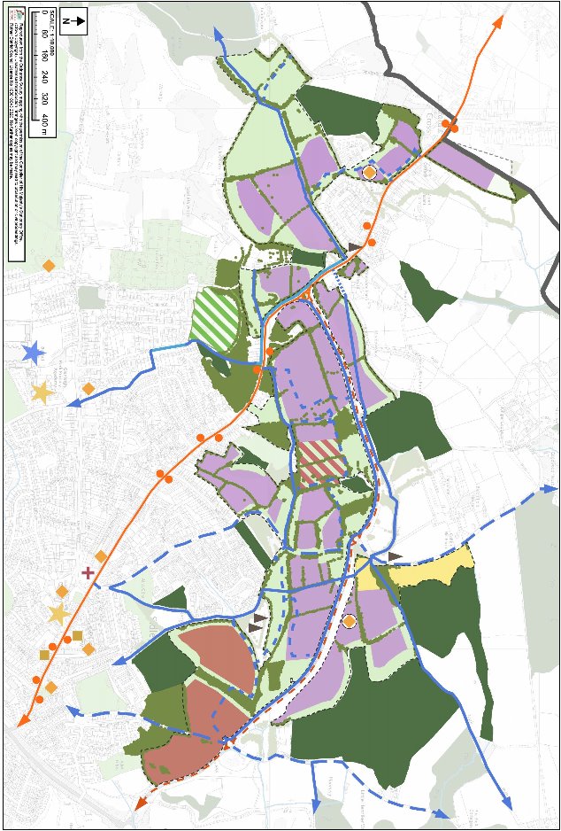
Policy BX27: Land south of Haven Brook Avenue – Infrastructure Comment
- In addition to meeting the requirements of Policy BX26 (North Bexhill Growth Area – Infrastructure Policy), the development of sites which are the subject of policies BX28, BX29, BX30 and BX31 shall contribute to shared infrastructure to serve those sites by:
- the provision of an overarching foul drainage strategy, in conjunction with Southern Water. Occupation of development to be phased to align with the delivery of sewerage infrastructure, in consultation with the service provider;
- the design and provision of complementary sustainable surface water drainage schemes in accordance with Policy ENV3;
- having regard to the transport requirements and impacts of the combined allocations and making proportionate financial contributions to off-site highway and cycleway/footpath improvements;
- as part of (iii) above, all developments off Watermill Lane should provide an integrated approach to ensuring safe and convenient movement for pedestrians and cyclists, as well as vehicles;
- ensuring an integrated approach to establishing a multi-functional ‘green corridor’ along the Combe Haven stream, extending from the A269 to the planned Enterprise Park (and beyond);
- as part of (v) above, all developments will contribute to the provision of outdoor sports facilities within site BX28, either directly or through proportionate (to the respective quantum of residential development) financial contributions;
- investigation of a common approach to securing superfast broadband.
- The above shared infrastructure requirements shall be implemented by a combination of direct provision and legal (s106) agreements attached to the respective development proposals.
10.198This policy relates to four sites south of Haven Brook Avenue, three of which were also allocated for development in the previous Local Plan. All four sites are subject to a planning application which is delegated to approve, subject to a Section 106 legal agreement.
10.19910.199 The four sites form an almost contiguous, large area of land which is suitable for residential development but which has its own infrastructure requirements (in addition to the overarching requirements of the wider North Bexhill growth area).
10.200Specific infrastructure requirements for this area include a major upgrade to the foul drainage system. There is also a requirement for a range of open space provision, including outdoor sports facilities, to serve new residential areas. The valley bottom of the Combe Haven stream is of ecological value, as well as having the potential to form a broad “green corridor” for both walking and cycling and as amenity green space integral to the setting of new development. It may also be suitable for local play provision and for mitigation of any biodiversity losses.
10.201Addressing the cumulative impacts of additional movements on the existing highway network and implementing associated traffic management and/or mitigation measures, as well as access arrangements for adjacent sites, also require a comprehensive and integrated approach to the provision of housing and infrastructure.
10.202Accessibility to local services requires careful attention. While the Ninfield Road benefits from regular bus services, and Haven Brook Avenue is also expected to be a bus route in the future, the nearest focus of local services is in Sidley District Centre. In fact, housing that is well connected to Sidley offers the opportunity to support the vitality of the District Centre. This is not to discount the provision of more local facilities to directly serve the new housing.
10.203Good connectivity for pedestrians and cyclists is important for both existing and new residents in the locality and should be improved. The developments should provide new and enhanced routes from the built-up area to main destinations, notably Sidley, the new business developments, larger recreational areas, the Countryside Park further to the east and the wider countryside. The green corridor along the valley bottom will be the main artery for sustainable travel, with outdoor sports facilities, natural amenity spaces and play areas accessible from it.
Policy BX28: Land at Kiteye Farm Comment
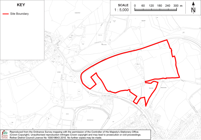
The site is allocated for residential-led mixed use development comprising:
- Some 300 new dwellings; and
- At least 2.64 hectares for open space, including provision for outdoor sports facilities.
Development on this site must:
- Provide a policy-compliant amount of on-site affordable housing in line with policy HOU2 of the Rother Local Plan;
- Deliver a new access arrangement onto Haven Brook Avenue, including measures to satisfactorily address any issues raised in a Road Safety Audit;
- Provide a fully accessible, safe and attractive pedestrian link between the site and Ninfield Road via the Kiteye Farm access;
- Provide accessible pedestrian routes connecting the two pedestrian accesses with nearest bus stops, including new footpaths and crossing points on Ninfield Road;
- Provide new bus stops on Haven Brook Avenue and upgrade existing Recreation Ground bus stops on Ninfield Road, including a suitable pedestrian crossing point;
- Contribute financially towards a new bus service along Haven Brook Avenue and towards a Car Share Club within the site for a period of three years;
- Ensure an integrated approach to establishing a multi-functional green corridor along the Combe Haven Stream, extending from the A269 to the planned Enterprise Park and beyond, including keeping the lower part of the valley open with an enhanced footpath–cycleway, incorporating a diversion to the north of Jim’s Place;
- Include no built development in the parts of the site which are within Flood Zones 2 and 3 and areas shown to be at risk of surface water flooding;
- Upgrade public right of way 56 and contribute financially towards future maintenance of the bridge located on public right of way 56;
- Keep the lower part of the valley open and laid out as part of a green corridor, with avenue tree planting along the edge of the site and intermediate landscaping;
- Ensure development adjacent to the A269/NBAR junction has principal elevations towards the roundabout;
- Prepare and implement a woodland management scheme for Birchen Shaw;
- Ensure that the outdoor sports facilities will be laid out at the same time as housing development, in accordance with a phasing plan to be agreed with the local planning authority;
- Ensure no more than 125 of the dwellings in the development are occupied until the scheme of highway works at the Bexhill Leisure Centre (A269) / King Offa Way (A259) junction has been fully implemented and opened to all traffic;
- Be designed so that residential development adjoining Haven Brook Avenue positively addresses and fronts onto the Avenue.
10.203The site comprises fields located between Ninfield Road and Haven Brook Avenue. The agricultural holding has been severed by construction of Haven Brook Avenue. The fields are relatively open, with only boundary trees, except for Birchen Shaw. There are no significant buildings within the site, though the modern farmhouse fronting Ninfield Road may need to be removed to facilitate access.
10.204This site was allocated for 250 dwellings through the previous Local Plan and has since been subject to planning applications for two separate sections. Permission for the larger section (for 250 dwellings) is delegated to approve while there is a separate application for additional dwellings in the western section. Additionally, further land adjacent to Haven Brook Avenue has now become available although much of this is wooded, undulating or contains ponds. Consequently, the site capacity has been increased to reflect these changes, although the overall density remains lower than for other parts of the two Live Well Locally areas in Bexhill. The policy requirements reflect the planning application. The site size is some 18 hectares.
10.205Development of this site is expected to deliver new access onto Haven Brook Avenue and Ninfield Road, safe pedestrian and cycle routes, and bus stop enhancements to promote sustainable travel. Where built development adjoins Haven Brook Avenue, it must positively address and front onto the Avenue, providing a positive, active and well-overlooked frontage through principal elevations, entrances and windows. Rear garden boundaries, blank or inactive elevations and parking-dominated frontages onto Haven Brook Avenue must be avoided.
10.206Public footpath Bexhill 56 runs adjacent to the Combe Haven watercourse, connecting Ninfield Road (west) to Watermill Lane (east). A section of this path crosses the site; development therefore provides an opportunity to integrate this existing footpath with new recreational routes, pedestrian and cycle links, and the NBAR cycleway, improving overall connectivity and permeability.
10.207The green corridor along the Combe Haven watercourse will need to be retained and enhanced, strengthening ecological connectivity, supporting nature recovery networks, and contributing to the multifunctional green infrastructure strategy for the site. Areas that Could be of Importance for Biodiversity (ACIBs), as identified in the Local Nature Recovery Strategy (LNRS) are located in the southern and eastern parts of the site, and a small area of designated ancient woodland bounds the site to the east. The development will need to include appropriate buffers and have regard to the Measures and Priorities in the LNRS.
10.208Also, areas around the Combe Haven watercourse are within Flood Zones 2 and 3 and also at risk of surface water flooding and therefore the development should be designed to avoid these parts of the site. The site lies within the Cuckmere and Pevensey Management Catchment (but not the Pevensey Levels Hydrological Catchment). Early engagement with the Lead Local Flood Authority and the Pevensey and Cuckmere Water Level Management Board will be needed to ensure the provision of appropriate Sustainable Drainage (SuDS) in accordance with Policy ENV3.
Policy BX29: Land west of Watermill Lane (south) Comment
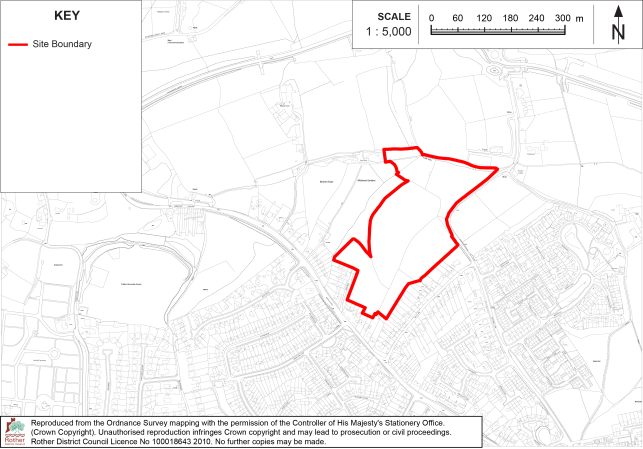
The site is allocated for residential development comprising some 130 new dwellings.
Development on this site must:
- Provide a policy-compliant amount of on-site affordable housing in line with policy HOU2 of the Rother Local Plan;
- Provide a new access onto Watermill Lane;
- Provide an improvement scheme on Watermill Lane to provide appropriate footway and carriageway widths between the site access and the Mayo Lane junction to the south;
- Provide a suitable pedestrian link with appropriate width footways on Watermill Lane to the north of the site and through to Haven Brook Avenue;
- Provide a pair of new bus stops on Haven Brook Avenue (one in each direction);
- Provide suitable measures to discourage the use of Mayo Lane by vehicular traffic and to improve pedestrian safety;
- Upgrade bus stops on Ninfield Road close to the Mayo Lane junction (2 in total) along with a suitable pedestrian crossing point;
- Contribute financially to establish the new bus service along Haven Brook Avenue;
- Include a green corridor in the northern part of the site towards the stream course, which is to be kept open and incorporate an enhanced footpath/cycleway, which should extend to the planned outdoor sports facilities (see Policy BX28) and form part of a multi-functional green corridor along the Combe Haven stream, extending from the A269 to the planned Enterprise Park (and beyond);
- Retain and safeguard trees on the western boundary, alongside a buffer to protect the Ancient Woodland of at least 15m depth;
- Include no built development in the parts of the site which are within Flood Zones 2 and 3 and areas shown to be at risk of surface water flooding;
- Pay due regard to the amenities of adjacent properties in terms of height and proximity of dwellings;
- Contribute to the provision of outdoor sports facilities within site BX28, either directly or through proportionate (to the respective quantum of residential development) financial contributions.
10.210The site comprises agricultural fields on the western side of Watermill Lane, south of the Combe Haven stream. It is situated between properties on the west side of Mayo Lane and the Allotment Gardens and is well related to the existing built-up area. It is within the Live Well Locally area and has a site size of 6.15 hectares.
10.211It was allocated for 130 dwellings through the previous Local Plan and is subject to a planning application which is delegated to approve. The policy reflects the previous allocation and planning application.
10.212Vehicular access needs to be off Watermill Lane, with the use of Mayo Rise restricted to cycle and pedestrian use, which should be facilitated through the development to Watermill Lane. It is recognised that Watermill Lane has no footway beyond its junction with Mayo Lane, necessitating works as far as Preston Lodge to ensure safe pedestrian movement. Provision of suitable measures to discourage the use of Mayo Lane by vehicular traffic and to improve pedestrian safety could potentially include new gateway features either end of the lane and possibly traffic calming measures. Other financial contributions include a Travel Plan auditing fee, and funding for a car share club within the site.
10.213 As with other development sites south of Haven Brook Avenue, development should help create the linear green space corridor along the adjacent length of the valley. An area of ancient woodland lies adjacent to the western boundary, forming part of a larger area identified in the Local Nature Recovery Strategy (LNRS) as an Area that Could be of Importance to Biodiversity (ACIB). Development will need include appropriate buffers and have regard to the Measures and Priorities detailed in the LNRS.
10.214The site lies within the Cuckmere and Pevensey Management Catchment (but not the Pevensey Levels Hydrological Catchment). Early engagement with the Lead Local Flood Authority and the Pevensey and Cuckmere Water Level Management Board will be needed to ensure the provision of appropriate Sustainable Drainage (SuDS) in accordance with Policy ENV3.
Policy BX30: Land west of Watermill Lane Comment
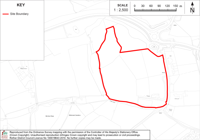
The site is allocated for residential development comprising some 80 new dwellings.
Development on this site must:
- Provide a policy-compliant amount of on-site affordable housing in line with policy HOU2 of the Rother Local Plan;
- Provide a new access onto Watermill Lane;
- Provide an improvement scheme on Watermill Lane to provide appropriate footway and carriageway widths between the site access and the Mayo Lane junction to the south;
- Provide a suitable pedestrian link with appropriate width footways on Watermill Lane to the north of the site and through to Haven Brook Avenue;
- Provide a pair of new bus stops on Haven Brook Avenue (one in each direction);
- Provide suitable measures to discourage the use of Mayo Lane by vehicular traffic and to improve pedestrian safety;
- Upgrade bus stops on Ninfield Road close to the Mayo Lane junction (2 in total) along with a suitable pedestrian crossing point;
- Contribute financially to establish the new bus service along Haven Brook Avenue;
- Include a green corridor in the northern part of the site towards the stream course, which is to be kept open and incorporate an enhanced footpath/cycleway, which should extend to the planned outdoor sports facilities (see Policy BX28) and form part of a multi-functional green corridor along the Combe Haven stream, extending from the A269 to the planned Enterprise Park (and beyond);
- Retain and safeguard trees on the western boundary, alongside a buffer to protect the Ancient Woodland of at least 15m depth;
- Include no built development in the parts of the site which are within Flood Zones 2 and 3 and areas shown to be at risk of surface water flooding;
- Pay due regard to the amenities of adjacent properties in terms of height and proximity of dwellings;
- Contribute to the provision of outdoor sports facilities within site BX28, either directly or through proportionate (to the respective quantum of residential development) financial contributions;
- Be designed so that residential development adjoining Haven Brook Avenue positively addresses and fronts onto the Avenue.
10.215This is a greenfield site comprising fields on the western side of Watermill Lane, immediately south of Haven Brook Avenue. It is subject to a planning application which is delegated to approve, and the policy criteria reflects both that application and the requirements of adjoining site allocations. The site is in the Live Well Locally Area Type and has a site size of 4.7 hectares and an indicative developable area of 3 hectares. It is allocated for some 80 dwellings at an indicative residential density of 26 dwellings per hectare.
10.216Together with the adjoining allocated sites, development should deliver a range of infrastructure and community benefits, ensuring that growth is sustainable, well-connected, and sensitive to the local environment. The site’s location provides opportunities to enhance connectivity along Watermill Lane and improve access to surrounding residential and employment areas.
10.217The development must support pedestrian safety and discourage unnecessary vehicular traffic through Mayo Lane. Potential measures could include gateway features at either end of the lane, traffic calming interventions, and enhanced pedestrian infrastructure. An appropriate pedestrian link should be provided from the site to Haven Brook Avenue to encourage walking and cycling, promoting a connected, active travel network. Measures to support sustainable travel will be required, including provision of bus stops and improvements to existing bus infrastructure.
10.218New access arrangements are necessary, including a new off-site access onto Watermill Lane and upgrades to the lane itself to provide adequate footway and carriageway widths between the site and the Mayo Lane junction. Where built development adjoins Haven Brook Avenue, it must positively address and front onto the Avenue, providing a positive, active and well-overlooked frontage through principal elevations, entrances and windows. Rear garden boundaries, blank or inactive elevations and parking-dominated frontages onto Haven Brook Avenue must be avoided.
10.219Environmental and amenity considerations are critical to the site’s design. The scheme should retain and safeguard trees along the western boundary and maintain a buffer of at least 15m to protect the adjacent Ancient Woodland. Areas that Could be of Importance to Biodiversity, as identified in the Local Nature Recovery Strategy, are on the western and southern edges of the site. Development will need to have regard to the Measures and Priorities set out in the LNRS. An integrated, multi-functional green corridor is required along the Combe Haven stream, connecting the A269 to the Enterprise Park and beyond, while ensuring the height and proximity of new dwellings respect the amenities of existing properties.
10.220Development will need to be avoided in the areas of the site in Flood Zones 2 and 3, along the southern boundary, as well as further areas at risk of surface water flooding predominately along the eastern and western boundaries. The site lies within the Cuckmere and Pevensey Management Catchment (but not the Pevensey Levels Hydrological Catchment). Early engagement with the Lead Local Flood Authority and the Pevensey and Cuckmere Water Level Management Board will be needed to ensure the provision of appropriate Sustainable Drainage (SuDS) in accordance with Policy ENV3.
10.221Contributions toward outdoor sports facilities in the adjoining site allocation and investigations into delivering superfast broadband will help ensure the development provides long-term benefits for both new and existing communities.
Policy BX31: Land east of Watermill Lane Comment
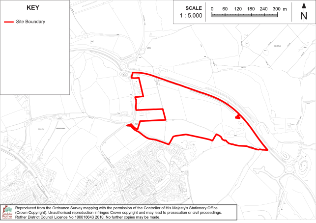
The site is allocated for residential development comprising some 170 new dwellings.
Development on this site must:
- Provide a policy-compliant amount of on-site affordable housing in line with policy HOU2 of the Rother Local Plan;
- Deliver associated public open space and landscaping;
- Retain the southern part of the site along the stream corridor as an open green corridor, incorporating an enhanced footway/cycleway extending from Watermill Lane to the planned Enterprise Park;
- Include no built development in the parts of the site which are within Flood Zones 2 and 3 and areas shown to be at risk of surface water flooding;
- Phase the occupation of development to align with the delivery of sewerage infrastructure, in consultation with the service provider;
- Provide vehicular access from Watermill Lane, subject to the findings of a Transport Assessment, with the expectation that:
- (a) A single access will be provided along the line of the existing farm track;
- (b) Traffic management measures are introduced on Watermill Lane to calm traffic, with specific regard to the short section north of Mayo Lane, in order to ensure the safe movement of pedestrians and cyclists between the site and Sidley in association with the provision of a new footway/cycleway;
- Contribute to shared infrastructure with adjoining sites in accordance with Policy BX27;
- Contribute financially to establish the new bus service along Haven Brook Avenue;
- Be designed so that residential development adjoining Haven Brook Avenue positively addresses and fronts onto the Avenue.
10.222The site comprises agricultural fields on the eastern side of Watermill Lane, south of Haven Brook Avenue. It is within the Live Well Locally Area Type, has a site size of 9.85 hectares and an indicative developable area of 5.5 hectares. It is allocated for some 170 new dwellings at an indicative density of 31 dwellings per hectare.
10.223The majority of the site was allocated for 150 dwellings through the previous Local Plan. Additional, adjoining land to the east alongside Haven Brook Avenue is also now available and while the majority of this additional land is not suitable for development due to its wooded nature, ponds and topography, it has been included in the site area to accommodate additional landscaping, public access and, potentially, a small increase in dwelling numbers.
10.224Areas around the Combe Haven watercourse in the southern part of the site are within Flood Zones 2 and 3 and also at risk of surface water flooding, these are also identified as an Area that Could Become of Importance for Biodiversity (APIB) in the Local Nature Recovery Strategy (LNRS). Development will need to avoid these parts of the site and incorporate them into a green corridor, taking into account the Measures and Priorities detailed in the LNRS. The site lies within the Cuckmere and Pevensey Management Catchment (but not the Pevensey Levels Hydrological Catchment). Early engagement with the Lead Local Flood Authority and the Pevensey and Cuckmere Water Level Management Board will be needed to ensure the provision of appropriate Sustainable Drainage (SuDS) in accordance with Policy ENV3.
10.225The eastern part of the site is subject to an outline planning application for the erection of up to 98 dwellings including affordable housing, with public open space, landscaping, sustainable drainage system (SuDS) and vehicular access. Where built development adjoins Haven Brook Avenue, it must positively address and front onto the Avenue, providing a positive, active and well-overlooked frontage through principal elevations, entrances and windows. Rear garden boundaries, blank or inactive elevations and parking-dominated frontages onto Haven Brook Avenue must be avoided.
Policy BX32: Land at Levetts Wood and Oaktree Farm Comment
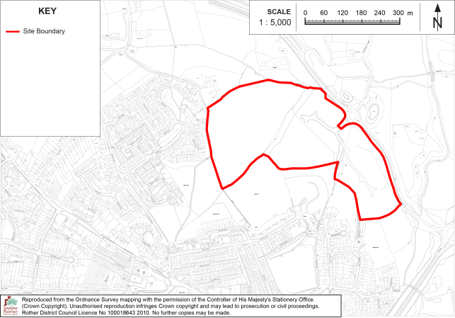
The site is allocated for employment development comprising some 38,000 sqm employment floorspace (net internal area) (Use Classes E(g), B2 or B8).
Development on this site must:
- Include vehicular, pedestrian and cycle access through the site and connections to existing public rights of way, and proposed cycleway and footpath networks including to the adjacent residential allocation (Policy BX31);
- Deliver a surface water drainage strategy based on sustainable drainage principles, including wetland habitats (SuDS ponds) designed to enhance ecological value and connectivity;
- Include no built development in the parts of the site which are within Flood Zones 2 and 3 and areas shown to be at risk of surface water flooding;
- Protect and manage rivers and streams, ponds and associated buffer zones, and ensure no development occurs within 8 metres of the Combe Haven main river;
- Maintain and reinforce existing landscaped boundaries around and within the site and include proposals for open spaces, landscape and woodland belts and buffers as an integral part of the proposals to link with the green corridor to be provided within the sites subject to policies BX28 to BX31;
- Include provision for the retention and future management of a buffer zone of semi-natural habitat, at least 15 metres wide, on the southern boundary, between the edge of development and the ancient woodland;
- Implement an ecological design strategy (EDS) to retain and enhance habitats, wildlife corridors, semi-natural habitats, and integrate features to support protected and priority species;
- Implement a comprehensive energy strategy to secure low carbon and renewable energy generation;
- Provide details of proposed bus provision measures sufficient to mitigate transport impacts prior to occupation of each phase.
10.226The site was allocated for employment floorspace through the previous Local Plan and was subject to an outline planning permission which has partly expired. A section in the eastern part of the site, however, has been constructed, and provides some 7,895 sqm of employment floorspace. The whole, original site is included in the allocation because the remaining sections lie either side of the constructed part.
10.227The plot ratio of the remaining sections of the site has been increased to 0.4 in line with up-to-date evidence[7] which has resulted in an increase in the amount of employment floorspace originally anticipated in the previous allocation. The allocation provides flexibility in terms of the specific use class of the employment use. The appropriate use class would be for determination at planning application stage, having regard to the nature of the particular proposal and the site constraints, including its proximity to planned and existing residential development, which may mean that B2 uses are less appropriate.
10.228Development is expected to come forward in a phased manner, ensuring that each phase delivers not only floorspace but also associated appropriate infrastructure, parking, SuDS, and landscaping to create a coherent and high-quality working environment.
10.229Given the site’s proximity to the Combe Haven SSSI, Levetts Wood Ancient Woodland, and associated ecological networks, strong environmental safeguards are necessary. The policy therefore requires:
- the delivery of green corridors and ecological buffer zones to maintain and enhance biodiversity;
- the provision of sustainable drainage systems (SuDS) designed to protect water quality and manage flood risk, including the creation of new wetland habitats; and
- the implementation of an ecological design strategy to support protected and priority species. This should take account of areas identified as ACIBs and APIBs in the Local Nature Recovery Strategy, and the Priorities and Measures therein.
10.230In addition, archaeological investigations and appropriate post-investigation assessments are required to ensure that the area’s heritage assets are properly safeguarded and recorded prior to or alongside development.
10.231The policy also requires the delivery of infrastructure to support sustainable transport choices, including new footpath and cycleway connections and bus service improvements. Together, these measures will ensure the site is fully accessible and that travel impacts on the local road network are appropriately mitigated.
10.232The allocation is expected to deliver a high-quality, sustainable employment site that contributes significantly to the district’s economic objectives while protecting and enhancing the natural and historic environment.
10.233The site lies within the Cuckmere and Pevensey Management Catchment (but not the Pevensey Levels Hydrological Catchment) although it is not shown to be at any significant risk of flooding. Nevertheless, early pre-application engagement with the Lead Local Flood Authority and the Pevensey and Cuckmere Water Level Management Board will be needed to ensure the provision of appropriate Sustainable Drainage (SuDS) in accordance with Policy ENV3.
Policy BX33: Land north of Haven Brook Avenue (east) Comment
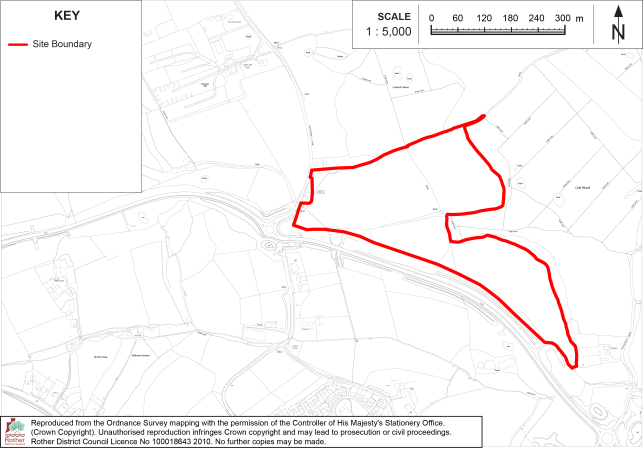
The site is allocated for a residential-led mixed use development comprising:
- up to 230 new dwellings;
- public open space and play-space to serve the development;
- community uses.
Development on this site must:
- Provide a policy-compliant amount of on-site affordable housing in line with policy HOU2 of the Rother Local Plan;
- Accord with Policy BX26 of this Plan (North Bexhill Growth Area – Infrastructure Policy) in terms of including direct provision of and/ or financial contributions towards all necessary infrastructure to serve the development along with development in the wider North Bexhill area;
- Comply with a whole-site masterplan, to be developed by the site promoter, to identify uses and areas for development, areas for green infrastructure (including public open space), and vehicular, pedestrian and cycle links, in line with the North Bexhill Masterplan Framework. The masterplan should be informed by a landscape and visual impact assessment, heritage assessment, ecological surveys and a sustainable drainage strategy, to determine an appropriate layout, form and detailed design that protects the landscape and character of the countryside to the north, and preserves and enhances adjacent heritage assets and the adjacent ancient woodland and Local Wildlife Site;
- Include community uses;
- Preserve and enhance the significance of the Grade II Listed Building, Cockerels Farmhouse, to the west of the site;
- Include provision for the retention and future management of a buffer zone of semi-natural habitat on the northern and eastern boundaries of the site, between the edge of development and the ancient woodland and Local Wildlife Site (the width of the buffer to be informed by ecological surveys),
- Be designed to prevent unauthorised public access to the woodland (other than via the existing public right of way) (but allow for wildlife), as informed by ecological surveys;
- Implement an ecological design strategy (EDS) to retain and enhance habitats, wildlife corridors, semi-natural habitats, and integrate features to support protected and priority species;
- Retain and enhance the existing hedgerows, trees and woodland within the site and on the site boundaries, except for any short sections of hedgerow that have to be removed to facilitate access, which should be minimised as far as possible;
- Include vehicular access from Haven Brook Avenue and/or Watermill Lane (while protecting the setting of the Listed Building) to include necessary improvements and infrastructure to meet the requirements of the Highway Authority;
- Provide new and improved pedestrian and cycle infrastructure outside the site to meet the requirements of the Highway Authority, including measures to link to the existing Pegasus crossing on Haven Brook Avenue, which could include a new footway on the northern side of Haven Brook Avenue, and additional crossing points;
- Maintain the existing public right of way within the site;
- Avoid built development in those areas of the site within Flood Zones 2 and 3 or are shown to be at risk of surface water flooding;
- Provide a connection to the local sewerage system at the nearest point of adequate capacity, in collaboration with the service provider;
- Phase the occupation of development to align with the delivery of sewerage infrastructure, in consultation with the service provider;
- Be designed so that residential development adjoining Haven Brook Avenue positively addresses and fronts onto the Avenue.
10.234The site comprises fields on the northern side of Haven Brook Avenue, east of Watermill Lane. It is within the Live Well Locally Area Type, has a site size of 11.5 hectares and an indicative developable area of 5.75 hectares. It is allocated for up to 230 dwellings at an indicative residential density of 40 dwellings per hectare.
Landscape Impacts
10.235It was intended through the previous Local Plan that Haven Brook Avenue would provide the edge between the urban area and the countryside to the north, however, with the construction of the road and the future construction of significant development on its southern side, the character of the wider area will change significantly. The fields comprising this site are clearly visible from the road, and their character is influenced by it. In landscape terms they could accommodate residential development without significantly impacting on views from the countryside further north.
10.236Nevertheless, there are landscape sensitivities. The southern-most field in particular is elevated, rising above the adjacent road, and development will appear prominent in views from the south, albeit as an extension to an existing/ planned urban extension. A high quality, landscape-led design will be needed, incorporating wide buffers to the adjacent ancient woodland. The northern-most field is more enclosed but also elevated, and more contiguous with the wider countryside to the north than the southern field. It also adjoins a Grade II listed building, Cockerels Farmhouse, detailed further below, which will necessitate a sensitive design and layout. Two public rights of way, Footpath 16b and 35a pass through this part of the site, 35a leading to the wider countryside to the north-east. The value of this access to the countryside will increase with the increase in residents resulting from the residential expansion on this northern side of Bexhill, and access to the PRoWs will need to be maintained and enhanced.
Ecological Impacts
10.237The site is bounded by ancient woodland to the north and east, which also forms a Local Wildlife Site. Wide buffers of semi-natural habitat will be needed, potentially larger than the 15 metres minimum, due to the high concentration of dwellings proposed in close proximity to the woodland and the potential for impacts arising from, for example, lighting, runoff, disturbance, and impacts from pets. The site will need to be carefully laid out to avoid lighting from dwellings impacting the woodland and should include measures to prevent public access to the woodland (while allowing for wildlife access). All of this will need to be informed by ecology surveys and an ecological design strategy to ensure adverse impacts to the woodland are avoided and the development protects and enhances the Local Wildlife Site.
10.238The majority of the site area is also identified as an Area that Could be of Importance to Biodiversity (ACIB) in the Local Nature Recovery Strategy (LNRS). Development will need to have regard to the Measures and Priorities detailed in the LNRS.
10.239The site lies within the Cuckmere and Pevensey Management Catchment (but not the Pevensey Levels Hydrological Catchment), and early engagement with the Lead Local Flood Authority and the Pevensey and Cuckmere Water Level Management Board will be needed to ensure the provision of appropriate Sustainable Drainage (SuDS) in accordance with Policy ENV3.
Heritage Impacts
10.240The site lies in the immediate setting of the Grade II listed Cockerels Farmhouse on Watermill Lane. Its significance is principally architectural and historic, as a modest pre-modern farmhouse whose value is enhanced by its legibility within a rural lane-side setting. The relationship between the farmhouse, Watermill Lane, the adjoining fields, retained hedgerows, trees and public right of way contributes to the ability to understand the building as part of a historically agricultural landscape.
10.241The principal heritage issue is likely to arise from the position and design of any new vehicular access, together with the extent to which built development encroaches towards Watermill Lane and the farmhouse. The site’s main access will need to be carefully designed and positioned to ensure the protection of Cockerels Farmhouse and the public right of way. Ideally, access would come from Haven Brook Avenue to avoid creating an engineered or overly urban road environment in the immediate setting of the listed building. Boundary treatments, junction geometry, visibility splays, lighting and signage should be minimised and designed with sensitivity to the rural lane character, while any necessary changes to hedgerows or trees should be kept to the absolute minimum.
10.242The indicative density of 40 dwellings per hectare should not be applied uniformly, to avoid the creation of a hard suburban edge close to Cockerels Farmhouse or along Watermill Lane. A heritage-led approach would require a reduced intensity of development in the western part of the site, with a generous landscape buffer, retained and reinforced field boundaries, and open space used to preserve separation between the farmhouse and new built form.
10.243In design terms, development within the part of the allocation closest to Cockerels Farmhouse should adopt a restrained, traditionally informed character which is subservient to the listed building. Materials, roof form, massing, scale, boundary treatment and landscape structure should respond to the rural farmhouse and lane-side context rather than introducing a standard estate character. The retained public right of way also provides an opportunity to structure open space and movement in a way that preserves an appreciation of the farmhouse within its wider setting, provided it is integrated as part of a green corridor rather than treated merely as an incidental route through built development. Where built development adjoins Haven Brook Avenue, it must positively address and front onto the Avenue, providing a positive, active and well-overlooked frontage through principal elevations, entrances and windows. Rear garden boundaries, blank or inactive elevations and parking-dominated frontages onto Haven Brook Avenue must be avoided.
Access and Sustainable Transport
10.244The site is adjacent to Watermill Roundabout alongside land which looks like part of the proposed highway verge (currently still in private ownership). Ideally, vehicular access to the site will come from the roundabout and/ or from Haven Brook Avenue (subject to the approval of the Highway Authority), to avoid impacts on the Grade II listed building, Cockerels Farmhouse, or the rural character of Watermill Lane. In any event, the access (and associated active travel infrastructure) will need to be carefully designed and positioned to ensure the protection of the listed building and also the retention of the public rights of way.
10.245New junctions will need to be compliant with Design Manual for Roads and Bridges (DRMB) standards, and the design informed by speed data and other necessary traffic surveys. A footway/cycleway would need to integrate into the site to connect to the southern part of Watermill Lane (via the existing crossing point on Haven Brook Avenue). Contributions towards regular bus services will be required, and potentially, the provision of bus stops.
10.246The site is currently not particularly well located in relation to services and facilities, notably a primary school. This will change to an extent with the development of the whole North Bexhill growth area, which will result in a mix of residential and employment uses and public open space in close proximity to the site. The site promoter has indicated that additional, adjoining land to the north of the site could be made available to accommodate a new primary school when this is required by the education authority to serve the additional population in the growth area. While this additional land appears to be large enough, it is sloping, and adjacent to ancient woodland and a Local Wildlife Site, and close to the listed building. Consequently, it is not included in the allocation at this time but identified on the North Bexhill masterplan as the most likely location for a primary school, when this is needed later in the Plan period.
Mix of Uses
10.247The site is one of the largest in the North Bexhill growth area, and centrally located with regard to planned development to the south. Consequently, it is suited to provide some form of community use in addition to residential development and associated open space, in order to assist the creation of a sustainable community. This could comprise, for example, a small community hall or multifunctional building which could accommodate uses such as a children’s nursery or medical uses (subject to demand) or flexible workspace.
Policy BX34: Land north of Haven Brook Avenue (west) Comment
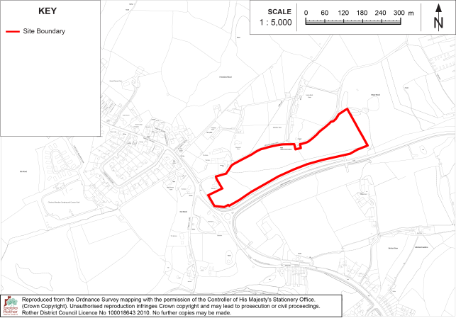
The site is allocated for a residential development of some 100 dwellings.
Development on this site must:
- Provide a policy-compliant amount of on-site affordable housing in line with policy HOU2 of the Rother Local Plan;
- Accord with Policy BX26 of this Plan (North Bexhill Growth Area – Infrastructure Policy) in terms of including direct provision of and/ or financial contributions towards all necessary infrastructure to serve the development along with development in the wider North Bexhill area;
- Be informed by a landscape and visual impact assessment to determine an appropriate layout, form and detailed design;
- Include vehicular access from Haven Brook Avenue or Ninfield Road to include necessary improvements and infrastructure to meet the requirements of East Sussex Council;
- Not include vehicular access from Freezeland Lane;
- Provide new and improved pedestrian and cycle infrastructure outside the site to include the extension of the shared footway/ cycleway on the northern side of Haven Brook Avenue/ Ninfield Road and additional crossing points to link the site to the existing paths on the southern side of Haven Brook Avenue and the eastern side of Ninfield Road (south);
- Maintain the existing public right of way within the site;
- Include provision for the retention and future management of a buffer zone of semi-natural habitat, at least 15 metres wide, on the eastern boundary of the site, between the edge of development and the ancient woodland;
- Retain and enhance the existing hedgerows, trees and woodland within the site and on the site boundaries, except for any short sections of hedgerow that have to be removed to facilitate access, which should be minimised as far as possible;
- Provide a connection to the local sewerage system at the nearest point of adequate capacity, in collaboration with the service provider;
- Phase the occupation of development to align with the delivery of sewerage infrastructure, in consultation with the service provider;
- Be designed so that residential development adjoining Haven Brook Avenue positively addresses and fronts onto the Avenue.
10.248This site comprises fields on the northern side of Haven Brook Avenue, north-east of the roundabout with Ninfield Road, and south of Freezeland Lane. It is within the Live Well Locally Area Type and has a site area of 4.7 hectares and an indicative developable area of 2.5 hectares. It could accommodate 100 dwellings at an indicative density of 40 dwellings per hectare.
10.249As with Policy BX33, the extension of development to the northern side of Haven Brook Avenue represents a change compared to the previous Local Plan. However, having regard to the significant development planned on the opposite side of Haven Brook Avenue and the resulting change to the character of the area, and the housing need of the district, it is considered that these fields can accommodate development without harmfully impacting on the wider countryside further north.
10.250As the fields are sloping, development will appear prominent from the south and from Freezeland Lane to the north, and consequently, a sensitive design, informed by a landscape and visual impact assessment, will be required. The layout will need to provide for the retention and enhancement of the public right of way through the site, as well as providing the appropriate buffers to the ancient woodland on the eastern boundary. Green infrastructure could be appropriate in the eastern and northern sections of the site to provide buffers to the countryside and woodland and protect the rural character of Freezeland Lane. All boundary trees and hedges should be retained (excepting any short sections required to be removed to facilitate access, which should be minimised as far as possible), including the large, mature trees adjacent to the southern boundary. The existing roadside hedge alongside Freezeland Lane should be protected and enhanced.
10.251The site is bounded by ancient woodland to the east. A wide buffer of semi-natural habitat will be needed, potentially larger than the 15 metres minimum, due to the high concentration of dwellings proposed in close proximity to the woodland and the potential for impacts arising from, for example, lighting, runoff, disturbance, and impacts from pets. The site will need to be carefully laid out to avoid lighting from dwellings impacting the woodland and should include measures to prevent public access to the woodland (while allowing for wildlife access), also having regard to the Measures and Priorities detailed in the Local Nature Recovery Strategy.
10.252Freezeland Lane is not suitable to provide vehicular access to the site due to its very narrow and winding nature, however the existing public footpath access should be retained and enhanced.
10.253The site lies within the Cuckmere and Pevensey Management Catchment (but not the Pevensey Levels Hydrological Catchment), and early engagement with the Lead Local Flood Authority and the Pevensey and Cuckmere Water Level Management Board will be needed to ensure the provision of appropriate Sustainable Drainage (SuDS) in accordance with Policy ENV3.
10.254The site could potentially also accommodate a community use or small class E units, preferably in its western section close to the junction with Ninfield Road. Where built development adjoins Haven Brook Avenue, it must positively address and front onto the Avenue, providing a positive, active and well-overlooked frontage through principal elevations, entrances and windows. Rear garden boundaries, blank or inactive elevations and parking-dominated frontages onto Haven Brook Avenue must be avoided.
Policy BX35: Land west of Ninfield Road roundabout Comment
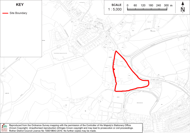
The site is allocated for a residential development of some 80 dwellings.
Development on this site must:
- Provide a policy-compliant amount of on-site affordable housing in line with policy HOU2 of the Rother Local Plan;
- Accord with Policy BX26 of this Plan (North Bexhill Growth Area – Infrastructure Policy) in terms of including direct provision of and financial contributions towards all necessary infrastructure to serve the development along with development in the wider North Bexhill area;
- Include vehicular access from Ninfield Road to include necessary improvements and infrastructure to meet the requirements of East Sussex Council;
- Not include vehicular access from St Mary’s Lane;
- Provide new and improved pedestrian and cycle infrastructure outside the site to allow linkage between the site and existing network infrastructure that has been otherwise secured, as required by the Highway Authority;
- Maintain and enhance public access to the existing public right of way (Bexhill 18) within the southern part of the site, including through an additional crossing point on Ninfield Road to the satisfaction of the Highway Authority, and, where possible, the inclusion of safety improvement measures where the footpath meets St Mary’s Lane to improve pedestrian access to St Mary’s Recreation Ground and Bexhill Cemetery;
- Include measures to ensure the protection of the ancient woodland to the west of the site (on the opposite side of St Mary’s Lane) and the Priority Habitat (deciduous woodland) to the south of the site;
- Retain and enhance the existing hedgerows, trees and woodland within the site and on the site boundaries, including the mature trees on the eastern site boundary, except for any short sections of hedgerow that have to be removed to facilitate access, which should be minimised as far as possible;
- Retain and enhance habitats within the southern part of the site as a multifunctional Green Infrastructure corridor, to include areas for Biodiversity Net Gain and enhanced amenity for the public footpath;
- Retain and protect existing ponds within the site and provide an appropriate buffer to any built development including roadways;
- Include no built development in the parts of the site which are shown to be at risk of surface water flooding;
- Incorporate appropriate SuDS in accordance with Policy ENV3 and be subject to Habitats Regulations Assessment screening to demonstrate beyond reasonable scientific doubt that these can be delivered on the site without harming the integrity of the Pevensey Levels Special Area of Conservation/RAMSAR site;
- Provide a connection to the local sewerage system at the nearest point of adequate capacity, in collaboration with the service provider;
- Phase the occupation of development to align with the delivery of sewerage infrastructure, in consultation with the service provider.
10.255The site comprises three adjoining plots which, together, form a triangular site between Ninfield Road (to the east) and St Mary’s Lane (to the west). It is within the Live Well Locally Area type and has a site size of 4.1 hectares and an indicative developable area of 2 hectares. It could accommodate some 80 dwellings at an indicative density of 40 dwellings per hectare.
10.256The site currently accommodates two large residential curtilages, and its southern section is undeveloped and contains scrub vegetation which links to deciduous woodland further south. There is a pond in the centre of the site which will require an appropriate buffer and parts of the site are at risk of surface water flooding.
10.257At present, the site forms part of a rural gap between Bexhill and Lunsford Cross/ The Thorne, characterised by scattered dwellings, small fields and pockets of woodland. However, the character of the area has changed with the construction of Haven Brook Avenue and the roundabout on Ninfield Road, which is adjacent to this site. The area will become yet more urbanised with the construction of the large residential extension around Haven Brook Avenue to the east. Consequently, it is considered this site is appropriate to accommodate additional residential development, and improved pedestrian and cycle connections towards Sidley District Centre (including the public rights of way network), also contributing towards the wider infrastructure requirements of the North Bexhill Growth Area. Where appropriate, development should positively address Ninfield Road, with buildings orientated to front onto the road and provide a positive, active and well-overlooked frontage through principal elevations, entrances and windows. Rear garden boundaries, blank or inactive elevations and parking-dominated frontages onto Ninfield Road must be avoided, while integrating and retaining important boundary trees and hedgerows where required by this policy.
10.258The southern part of the site is identified as an Area that Could become of Importance to Biodiversity (ACIB) in the Local Nature Recovery Strategy (LNRS). There are also records of priority species, including White Admiral butterfly, in the locality. Development in this southern section (which also has flood risks) should therefore be limited, and habitats conserved and enhanced as part of an area of green infrastructure containing the public right of way. Proposals should have regard to the Priorities and Measures identified in the LNRS.
10.259The site lies within the Pevensey Levels Hydrological Catchment. Therefore, the proposal would need to include appropriate Sustainable Drainage (SuDS) with at least three treatment stages, in accordance with Policy ENV3. Early pre-application engagement with the Lead Local Flood Authority and the Pevensey and Cuckmere Water Level Management Board will be needed.
Policy BX36: Land west of Ninfield Road Comment
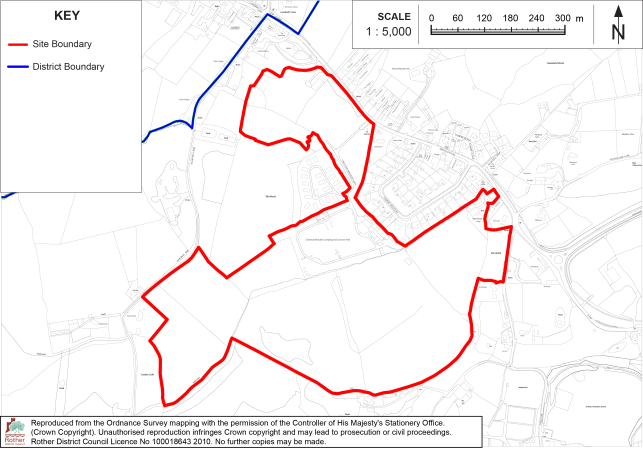
The site is allocated for a residential-led mixed use development comprising:
- some 400 dwellings;
- a retail and community building comprising new convenience retail floorspace and a separate community space suitable to accommodate uses such as community clubs, also with a mobility hub to include cycle parking, EV charging, electric car club (if required) and public transport infrastructure (if required);
- public open space (potentially including formal outdoor sports provision) and play-space.
Development on this site must:
- Provide a policy-compliant amount of on-site affordable housing in line with policy HOU2 of the Rother Local Plan;
- Accord with Policy BX26 of this Plan (North Bexhill Growth Area – Infrastructure Policy) in terms of including direct provision of and financial contributions towards all necessary infrastructure to serve the development along with development in the wider North Bexhill area;
- Be informed by a landscape and visual impact assessment and heritage assessment to determine an appropriate layout, form and detailed design, conserving and enhancing the setting of heritage assets and providing an appropriate settlement edge;
- Include a Minerals Resource Assessment to evidence the extent of the mineral resource across the site, whether any identified clay and/or sand resource would be sterilised, whether prior extraction would be feasible, the likely operational impacts on Ashdown Brickworks, and how any conflict between the proposed development and existing quarry activity would be avoided or mitigated;
- Include vehicular access(es) from Ninfield Road to include necessary improvements and infrastructure to meet the requirements of the Highway Authority;
- Not include vehicular access from Pear Tree Lane (other than any emergency access demonstrated to be necessary);
- Retain the public right of way within the site and include new pedestrian and cycle links within the site, linking to existing public rights of way and public highways outside the site;
- Provide pedestrian and cycle infrastructure outside the site to allow linkage between the site and existing network infrastructure or network infrastructure that has otherwise been secured, to be approved by the Highway Authority;
- Include improvements to public transport infrastructure outside the site;
- Include substantial areas of public open space and areas for Biodiversity Net Gain across the site in accordance with Local Plan policy;
- Include areas of play space (including equipped play space) and potentially, formal outdoor sports provision;
- Protect the amenity of users of the holiday caravan park adjacent to the site and provide for its continued use;
- Retain a minimum 15 metres wide undeveloped buffer area to all designated ancient woodland within and adjacent to the site;
- Retain and enhance the existing hedgerows, trees and woodland within the site and on the site boundaries except for any short sections of hedgerow that have to be removed to facilitate access, which should be minimised as far as possible;
- Preserve or enhance the significance of the Grade II Listed Building, The High House, to the north of the site;
- Incorporate appropriate Sustainable Drainage (SuDS) in accordance with Policy ENV3 and be subject to Habitats Regulations Assessment screening to demonstrate beyond reasonable scientific doubt that these can be delivered on the site without harming the integrity of the Pevensey Levels Special Area of Conservation/RAMSAR site;
- Include no built development in the parts of the site which are shown to be at risk of surface water flooding;
- Provide a connection to the local sewerage system at the nearest point of adequate capacity, in collaboration with the service provide;
- Phase the occupation of development to align with the delivery of sewerage infrastructure, in consultation with the service provider.
10.260This is a large site comprising a series of agricultural fields, a single vacant dwelling and agricultural buildings, and land currently in use as a holiday caravan park. It is within the Live Well Locally Area type, has a site size of some 28 hectares and an indicative developable area of some 10 hectares. It could accommodate some 400 dwellings at an indicative residential density of 40 dwellings per hectare. It offers an opportunity for a strategic scale, residential-led development.
Landscape, Ecological and Heritage Impacts
10.261The site is relatively enclosed in the landscape although there are longer views from its western edge across the countryside. The topography is undulating and the fields to the south slope quite steeply downwards. Development would need to be carefully designed to create a new settlement edge, informed by a Landscape and Visual Impact Assessment. An appropriate variety of residential densities should be included across the site, the highest densities best suited to those areas more closely related to the existing built form. Existing boundary trees and hedgerows would need to be retained and enhanced with new planting. Where appropriate, development should positively address Ninfield Road, with buildings orientated to front onto the road and provide a positive, active and well-overlooked frontage through principal elevations, entrances and windows. Rear garden boundaries, blank or inactive elevations and parking-dominated frontages onto Ninfield Road must be avoided, while integrating and retaining important boundary trees and hedgerows where required by this policy.
10.262There is a small area of ancient woodland in the eastern part of the site, and a larger area adjacent to the western boundary, these are also identified as Areas of Particular Importance for Biodiversity (APIBs) in the Local Nature Recovery Strategy. Appropriate buffers and enhancements would be required, together with measures to prevent inappropriate public access, and the site layout should be carefully designed to minimise impacts, including from lighting, disturbance and pets.
10.263A public footpath passes through the site, which will need to be retained and enhanced as part of the development.
10.264 A Grade II listed building, The High House, is adjacent to the eastern boundary and its setting will need to be preserved and enhanced. In particular, any works to create a new site access in this location, or works to the existing track (which is also a public footpath) will need to be sensitively designed to ensure an urbanising feature is not created which could harm its setting. The design will need to be informed by a Heritage Statement in line with Policy HER1.
Water and Flooding Impacts
10.265There are some areas at risk of surface water flooding, and the site lies within the Pevensey Levels Hydrological Catchment. Therefore, the proposal would need to include appropriate Sustainable Drainage (SuDS) with at least three treatment stages, in accordance with Policy ENV3. Early pre-application engagement with the Lead Local Flood Authority and the Pevensey and Cuckmere Water Level Management Board will be needed.
Impact on Ashdown Brickworks
10.266 The southern part of the site lies within a Minerals Consultation Area (MCA) and Waste Consultation Area (WCA) for Ashdown Brickworks. Ashdown Brickworks is an operational brickworks and clay quarry and is permitted to continue to operate until 2051. However, should the working not be completed by this date, the operator could apply to extend this. It is one of only a few brickworks in the county, and its continued operation is essential for the supply of bricks for construction projects in the area. It is also considered as a safeguarded waste site owing to the brick recycling operation that also takes place on site. Therefore, policies of the Waste and Minerals Plan apply, which seek to safeguard against non-minerals development and ensure that where non-waste development is proposed, account is taken of the need to safeguard waste management capacity and avoid constraining its operation.
10.267It is understood that the quarry operates a campaign method of extraction, where quarrying occurs for short, intense periods. Brick clay is worked from the quarry in phases. There remains a significant amount of clay to be extracted and, according to approved plans, extraction and restoration within the northern phase (closest to this site) is yet to commence. Therefore, unless carefully designed and laid out, development has the potential to curtail clay extraction, contrary to the Waste and Minerals Plan. Furthermore, quarrying activities may cause noise and disturbance to new residents of the site.
10.268To address these issues, the policy requires a Minerals Resource Assessment (MRA) to be prepared to support a planning application, which would identify whether any minerals resources would be sterilised, whether prior extraction would be feasible, and how any conflict between the proposed development and existing quarry activity would be avoided or mitigated. The MRA will need to inform the detailed layout and design of the development. This is likely to mean that built development will not be permitted in the southern parts of the site.
Access and Sustainable Transport
10.269The site is not currently well located in relation to services and facilities, and consequently, the site must provide some of its own facilities as well as contributing to wider infrastructure requirements in the West Bexhill Growth Area in accordance with Policy BX26.
10.270 In particular, sustainable transport links and options to Sidley district centre and Bexhill town centre will need improvement. This will include (but not necessarily be limited to) connections to the Public Rights of Way network, enhancements to Public Rights of Way and cycleway/ footway infrastructure off-site, the provision of additional pedestrian and cycle infrastructure to link to existing provision off-site, improvements to bus stops and contributions to bus services.
10.271A mix of uses is also required, including a retail unit, community facilities and a mobility hub. Outdoor sports provision on-site should be explored by the site promoter, and if found not to be feasible, off-site improvements will be required in accordance with Policy BX26.
10.272Vehicular access will be from Ninfield Road to the north-east. The site also borders Pear Tree Lane to the north, but this is narrow and winding with no footways and is not suitable for any vehicular access, other than emergency access (if this is demonstrated to be necessary).
10.273The reduction in the size of the holiday caravan park (partly within the site) is a consideration, although part of this lies outside the site boundary and would remain, with the loss being limited to a field for touring caravans. While this would have some impact on the local economy, the benefits arising from a significant residential development are considered to outweigh the harm, providing that a sustainable community with a range of transport options and some retail/community facilities on site can be created together with other necessary infrastructure on and off the site.
Policy BX37: Land at St Francis Farm, Ninfield Road Comment
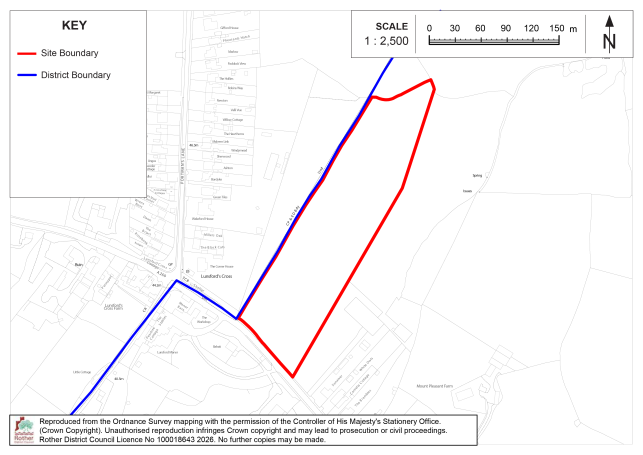
The site is allocated for a residential development of some 70 dwellings.
Development on this site must:
- Provide a policy-compliant amount of on-site affordable housing in line with policy HOU2 of the Rother Local Plan;
- Accord with Policy BX26 of this Plan (North Bexhill Growth Area – Infrastructure Policy) in terms of including direct provision of and financial contributions towards all necessary infrastructure to serve the development along with development in the wider North Bexhill area;
- Be informed by a landscape and visual impact assessment to determine an appropriate layout, form and detailed design, conserving and enhancing the setting of heritage assets and providing an appropriate settlement edge;
- Include vehicular access from Ninfield Road to include necessary improvements and infrastructure to meet the requirements of the Highway Authority;
- Not include vehicular access from Potmans Lane (other than any emergency access demonstrated to be necessary);
- Provide pedestrian and cycle infrastructure outside the site to allow linkage between the site and existing network infrastructure or network infrastructure that has otherwise been secured, to be approved by the Highway Authority;
- Include improvements to public transport infrastructure outside the site;
- Include public open space and areas for Biodiversity Net Gain across the site in accordance with Local Plan policy;
- Retain and enhance the existing hedgerows, trees and woodland within the site and on the site boundaries except for any short sections of hedgerow that have to be removed to facilitate access, which should be minimised as far as possible;
- Incorporate appropriate Sustainable Drainage (SuDS) in accordance with Policy ENV3 and be subject to Habitats Regulations Assessment screening to demonstrate beyond reasonable scientific doubt that these can be delivered on the site without harming the integrity of the Pevensey Levels Special Area of Conservation/RAMSAR site;
- Include no built development in the parts of the site which are shown to be at risk of surface water flooding;
- Provide a connection to the local sewerage system at the nearest point of adequate capacity, in collaboration with the service provider;
- Phase the occupation of development to align with the delivery of sewerage infrastructure, in consultation with the service provider.
10.274The site comprises a field on the northern side of Ninfield Road, within the Live Well Locally Area type, The total field measures 3.7 hectares but it lies partly within Wealden District. The developable section within Rother District (estimated to be 1.75 hectares) could accommodate some 70 dwellings at an indicative residential density of 40 dwellings per hectare.
10.275The site has few environmental constraints other than boundary hedgerows and a band of woodland containing a stream on its northern boundary, with an associated area at risk of surface water flooding. The site also lies partly within the Pevensey Levels Hydrological Catchment, meaning development would need to include appropriate Sustainable Drainage (SuDS) with at least three treatment stages, in accordance with Policy ENV3. Early pre-application engagement with the Lead Local Flood Authority and the Pevensey and Cuckmere Water Level Management Board will be needed.
10.276Additionally, in its current undeveloped form, the site, being grassland, provides wildlife habitat. Development would need to include biodiversity net gain on site, in accordance with local plan policy and legislation.
10.277In landscape terms the site is relatively enclosed, although there are some longer views gained northwards. Development will need to be high quality and landscape-led, informed by a Landscape and Visual Impact Assessment to ensure an appropriate new settlement edge is created. All trees and hedges on site boundaries will need to be retained. Where appropriate, development should positively address Ninfield Road, with buildings orientated to front onto the road and provide a positive, active and well-overlooked frontage through principal elevations, entrances and windows. Rear garden boundaries, blank or inactive elevations and parking-dominated frontages onto Ninfield Road must be avoided, while integrating and retaining important boundary trees and hedgerows where required by this policy.
10.278 Like site BX36 on the opposite side of Ninfield Road, the site is not currently well located in relation to services and facilities, and consequently, the site must contribute to wider infrastructure requirements in the West Bexhill Growth Area in accordance with Policy BX26. In particular, sustainable transport links and options to Sidley district centre and Bexhill town centre will need improvement. This will include (but not necessarily be limited to), enhancements to cycleway/ footway infrastructure off-site, the provision of additional pedestrian and cycle infrastructure to link to existing provision off-site, improvements to bus stops and contributions to bus services.
Policy BX38: Land at Freezeland Farm, Freezeland Lane Comment
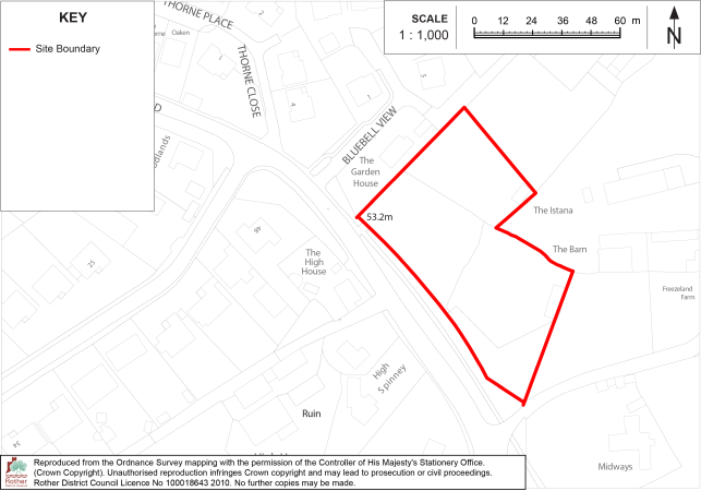
The site is allocated for a residential development comprising some 5 dwellings.
Development on this site must:
- Include a new vehicular access from Ninfield Road.
- Include new pedestrian and cycle links to Ninfield Road.
- Retain the existing hedgerows and trees to all boundaries of the site.
- Be carried out in accordance with the recommendations contained within a tree survey to ensure that protected trees (TPO388) are conserved during works on site.
- Be informed by a biodiversity strategy that makes provision for any protected species found to be using the site, and where necessary, includes appropriate mitigation and/ or compensation for any loss of habitat.
- Protect the setting of the Grade II listed building (The High House) opposite the site.
10.279The site is located on the corner of Ninfield Road and Freezeland Lane. It is comprised of a field enclosed by well-established hedgerows and mature trees, with a workshop to the south. It is within the Live Well Locally Area Type and has an indicative developable area of 0.25 hectares. It can accommodate some 5 dwellings at an indicative density of 30 dwellings per hectare.
10.280The site has outline planning permission for 5 dwellings, which has not yet been implemented. Environmental and other constraints affecting the site include the whole area being covered by a Tree Protection Order (TPO388), with adjacent areas at risk of surface water flooding and a Grade II Listed Building (The High House) opposite. The policy requirements detailed above reflect the planning permission and these constraints.
10.281The site lies within the Cuckmere and Pevensey Management Catchment (but not the Pevensey Levels Hydrological Catchment). Therefore, early engagement with the Lead Local Flood Authority and the Pevensey and Cuckmere Water Level Management Board will be needed to determine appropriate Sustainable Drainage (SuDS) measures for the site.
10.282The site is located some distance to amenities and services available in Bexhill. However, there is a bus stop located in close proximity to the entrance of the site, and on balance, given its small scale, is considered acceptable in sustainability terms.
Policy BX39: Former Sidley Sports Ground, Glovers Lane Comment
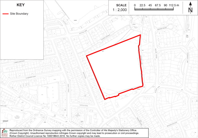
The site is allocated for residential development comprising some 50 dwellings (subject to alternative and agreed reprovision of sports pitch and associated facilities).
Development on this site must:
- Make provision for the construction of an appropriately specified 3G artificial grass pitch at an alternative, accessible and suitable location as agreed by the Council, which shall be provided prior to the occupation of any dwellings at the site;
- Provide a policy-compliant amount of on-site affordable housing in line with policy HOU2 of the Rother Local Plan;
- Include public open space and play space within the site;
- Protect the amenity of occupiers of properties bordering the site;
- Phase the occupation of development to align with the delivery of sewerage infrastructure, in consultation with the service provider.
- Include no built development in the parts of the site which are shown to be at risk of surface water flooding.
10.283The site was previously the sports ground of Sidley United Football Club and was also used by Sidley Cricket Club and Sidley Social Club but has been disused since around 2013. It was allocated through the previous Local Plan for a 3G artificial grass pitch, a community hub and open space but has remain closed. The site was allocated as an Asset of Community Value in 2018, but the landowner declined to sell the site to the community group.
10.284Current evidence indicates that the site is unavailable for its previously allocated use (and its previous use as sports pitches and a social club). The landowner has indicated that the site is available for a residential development. In principle, the site is in a sustainable location for housing. It is in the Suburban Area Type and could accommodate some 50 dwellings at an indicative residential density of 60 dwellings per hectare.
10.285However, the loss of a sports pitch and open space at the site is contrary to national planning policy unless it is demonstrated they are surplus to requirements or the loss would be replaced by equivalent or better provision in terms of quantity and quality in a suitable location. The loss of a community facility (i.e. the social club) is contrary to Local Plan policy. Consequently, residential development at the site can only be supported if the developer provides a 3G pitch and associated facilities in a suitable alternative location. An assessment as to whether there is a need for a replacement cricket pitch will also be required, together with resulting provision or a contribution towards provision (if needed). In terms of the social club, this will also be required to be provided in an alternative location unless it is demonstrated that the requirements of the first part of Policy HWB3 (4) (a) are met, i.e. that alternative provision of the equivalent or better quality is already available in the local area. Even if this is the case, contributions towards improvements to existing community facilities may be necessary.
10.286Site(s) for an alternative facility/ facility would need to be agreed by the Council and secured, prior to any planning permission for an alternative use at this site being granted. The alternative facility/ facilities would need to be provided prior to the occupation of any dwellings on this site and thereafter retained.
10.287Residential development will need to avoid the areas to the south of the site, at risk of surface water flooding. The site is surrounded on all four sides by dwellings and therefore the amenity of those existing residents must be protected. Development will need to be of a high-quality design, and the site will need to accommodate green infrastructure including open space and play space. Suitable access and parking arrangements will need to be included in line with the policies of the Live Well Locally chapter.
10.288The site lies within the Cuckmere and Pevensey Management Catchment (but not the Pevensey Levels Hydrological Catchment). Early engagement with the Lead Local Flood Authority and the Pevensey and Cuckmere Water Level Management Board will be needed to develop a suitable sustainable drainage scheme.
Policy BX40: Land adjacent to 276 Turkey Road, Bexhill Comment
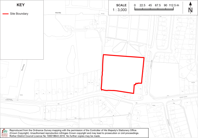
The site is allocated for residential development comprising some 30 dwellings.
Development on this site must:
- Provide a policy-compliant amount of on-site affordable housing in line with policy HOU2 of the Rother Local Plan;
- Include an appropriate access onto Turkey Road, including any necessary off-site highway works necessary to make the development acceptable;
- Include provision for the retention and enhancement of boundary planting, particularly in relation to the existing Tree Preservation Order on the site;
- Make provision for an acceptable connection to the local sewerage system in agreement with the service provider;
- Include no built development in the parts of the site which are shown to be at risk of surface water flooding;
- Incorporate appropriate Sustainable Drainage (SuDS) in accordance with Policy ENV3 and be subject to Habitats Regulations Assessment screening to demonstrate beyond reasonable scientific doubt that the development can be delivered on the site without harming the integrity of the Pevensey Levels Special Area of Conservation/RAMSAR site.
10.289This is an undeveloped greenfield site in the Suburban Area Type. It has an indicative developable area of 0.75 hectares and can accommodate some 30 dwellings at an indicative density of 40 dwellings per hectare. The policy carries forward an allocation from the previous Local Plan.
10.290There are three residential properties adjacent to the south-eastern corner of the site, with a further residential property along the western boundary. Bexhill Cemetery lies to the east and north of the site.
10.291The site is partially contained from wider views by the boundary trees but there are more localised views into the site. There is an existing Tree Preservation Order (TPO 312) along the western and southern boundaries. Development of the site would require the protection of existing trees and hedgerows, including suitable buffers and provision of additional landscaping. The Local Nature Recovery Strategy (LNRS) identifies the cemetery to the north as an Area that Could Become of Importance for Biodiversity (ACIB), and an area of ancient woodland some 25 metres to the east as an Area of Particular Importance for Biodiversity (APIB). Development will need to include Biodiversity Net Gain within the site and have regard to the Measures and Priorities set out in the LNRS.
10.292The site is relatively well located in terms of access to some services, notably schools and is close to existing bus routes. There is no footpath on the northern side of Turkey Road, but the site can be linked to footpaths on the opposite side of the road. The most likely access point is at the south-west corner of the site onto Turkey Road. Highway improvements will be required to make the development acceptable.
10.293 The site lies within the Pevensey Levels Hydrological Catchment, meaning development would need to include appropriate Sustainable Drainage (SuDS) with at least three treatment stages, in accordance with Policy ENV3. Early pre-application engagement with the Lead Local Flood Authority and the Pevensey and Cuckmere Water Level Management Board will be needed.
Policy BX41: Cemetery Lodge, 250 Turkey Road, Bexhill Comment
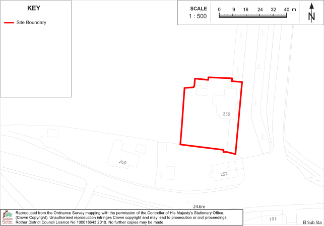
The site is allocated for residential development comprising some 6 affordable dwellings.
Development on this site must:
- Include the conversion and extension of the existing building within the site;
- Comprise of affordable housing;
- Improve the vehicular access from the junction of St Marys Lane and Turkey Road to meet the requirements of the Highway Authority;
- Include new pedestrian and cycle links to Turkey Road;
- Retain the existing hedgerows and trees to all boundaries of the site;
- Be in accordance with a tree survey to ensure that designated trees are protected during works on site;
- Incorporate appropriate Sustainable Drainage (SuDS) in accordance with Policy ENV3 and be subject to Habitats Regulations Assessment screening to demonstrate beyond reasonable scientific doubt that the development can be delivered on the site without harming the integrity of the Pevensey Levels Special Area of Conservation/RAMSAR site.
10.294The site is located on the corner of St Mary’s Lane and Turkey Road, in the Suburban Area Type. It is currently occupied by a vacant building formerly in office use.
10.295Planning permission was granted in 2023 for conversion and extension of the existing building to provide 6 affordable flats with car parking and landscaping which has not yet been implemented. The existing building has a distinct character which should be maintained and reflected in the extension, in terms of design and massing.
10.296Environmental and other constraints affecting the site include protected trees to the southern boundary, Ancient Woodland and Priority Habitat nearby on the opposite side of St Mary’s Lane and risks of surface water on adjoining land.
10.297The site lies within the Pevensey Levels Hydrological Catchment, meaning development would need to include appropriate Sustainable Drainage (SuDS) with at least three treatment stages, in accordance with Policy ENV3. Early engagement with the Lead Local Flood Authority and the Pevensey and Cuckmere Water Level Management Board will be needed.
10.298The site is well located in relation to town services but improvements to pedestrian and cycle infrastructure to encourage active travel are required, as detailed above.
Policy BX42: Our Lady of the Rosary Church, Southlands Road Comment
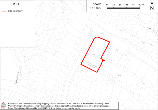
The site is allocated for residential development comprising some 8 new dwellings.
Development on this site must:
- Include appropriate access or crossovers to service the layout of the development, onto Southlands Road.
- Include new pedestrian links to Southlands Road.
- Ensure that it does not unreasonably harm the amenities of nearby residential development in terms of loss of light, massing or overlooking.
- Incorporate appropriate Sustainable Drainage (SuDS) in accordance with Policy ENV3 and be subject to Habitats Regulations Assessment screening to demonstrate beyond reasonable scientific doubt that the development can be delivered on the site without harming the integrity of the Pevensey Levels Special Area of Conservation/RAMSAR site.
10.299This is a brownfield site at the junction of Ninfield Road and Southlands Road in Sidley. It is within the Suburban Area Type and has an indicative developable area of 0.13 hectares. It could accommodate some 8 dwellings at a density of 60 dwellings per hectare.
10.300The site is currently occupied by a church, an ancillary hall, amenity space and hardstanding. There is a commercial property to the northeast, a three-storey block of sheltered accommodation to the east (Lawrence House), together with residential properties to the north, west and south. It is well located in relation to services in Sidley district centre. Planning permission was granted in 2024 for demolition of the existing church hall units and provision of eight dwellings comprised of six semi-detached dwellings and two detached bungalows, which have not yet been constructed. The policy requirements reflect the planning permission.
10.301The site lies within the Pevensey Levels Hydrological Catchment, meaning development would need to include appropriate Sustainable Drainage (SuDS) with at least three treatment stages, in accordance with Policy ENV3. Early engagement with the Lead Local Flood Authority and the Pevensey and Cuckmere Water Level Management Board will be needed.
Policy BX43: Land at Worsham Farm (East) Comment
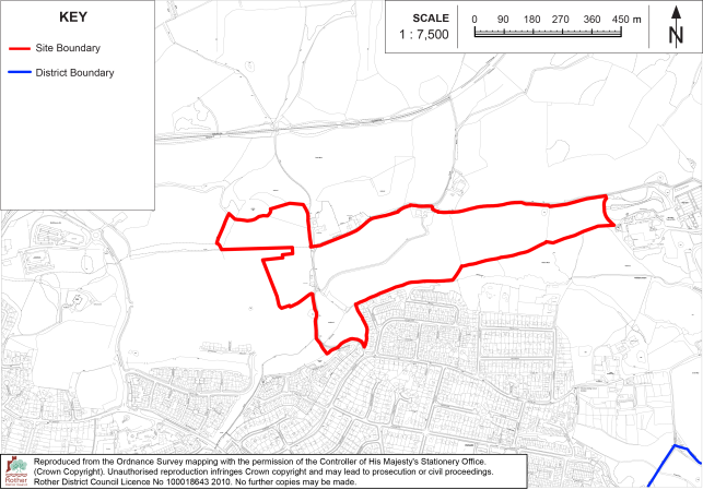
The site is allocated for residential-led mixed use development comprising:
- Some 354 new dwellings;
- Up to a two-form entry primary school with Early Years nursery provision;
- Three formal sports pitches and associated pavilion building and parking;
- Community building;
- Public open space.
Development on this site must:
- Accord with the requirements of planning permissions RR/2022/2477/P and RR/2024/501/P (or commensurate requirements, in the event of these permissions not being implemented);
- Deliver the school, sports pitches and associated development, community building and public open space in line with the agreed phasing;
- Provide a policy compliant amount of affordable housing;
- Be phased in accordance with the approved Section 106 legal agreement;
- Deliver a spine road connection through the site;
- Provide new and improved connections for pedestrians and cyclists, including continuation of the shared footpath and cycleway along the spine road;
- Provide suitable on-site parking provision;
- Retain and protect existing habitats and hedgerows where possible, with compensatory planting where loss is unavoidable;
- Retain a minimum 15 metres wide undeveloped buffer area to all designated ancient woodland within and adjacent to the site;
- Deliver a comprehensive landscaping scheme, including mature planting, to establish a strong landscape structure throughout the site.
- Secure long-term conservation of the landscape and biodiversity enhancements through a Landscape and Ecological Management Plan;
- Design and implement appropriate flood risk management and include no built development in the parts of the site within Flood Zones 2 and 3 or which are shown to be at risk of surface water flooding;
- Incorporate and implement ecological mitigation and enhancements;
- Safeguard the setting of the Grade II listed Boulder Cottage and nearby non-designated heritage assets, providing relief and landscaping around these assets to maintain their rural context;
- Provide estate roads and plot accesses designed to adoption standards and secure technical approval with the Highway Authority;
- Contribute to bus service and infrastructure improvements as required.
10.302Land at Worsham Farm (East) forms part of the wider Worsham Farm strategic mixed-use development, originally permitted under outline consent RR/2015/1760/P. The site now allocated includes those parts of the site which have not yet commenced, including the third main phase of dwellings, primary school, formal playing pitches, community building and open space. These developments benefit from Reserved Matters approval (RR/2022/2477/P and RR/2024/501/P) and the policy takes forward those approvals.
10.303The provision of a spine road through the site, with integrated pedestrian and cycle links, is essential to ensure access and multi modal connectivity to the wider area and access to the adopted highway network, particularly the A2691 Mount View Street.
10.304The landscape context is sensitive, with the site bounded by, and partly containing ancient woodland and a Local Wildlife Site and interspersed with hedgerows. While some hedgerow loss is unavoidable to enable access and delivery of housing numbers approved at outline stage, compensatory planting, together with a comprehensive landscaping scheme and mature planting, will deliver a robust landscape structure. Long-term landscape management and biodiversity enhancements will be secured through a Landscape and Ecological Management Plan. Proposals will need to take account of the Priorities and Measures of the Local Nature Recovery Strategy, and public open space positions carefully to ensure no recreational impacts on designated habitats.
10.305 The site lies immediately east of the Grade II listed Boulder Cottage and south of several historic agricultural buildings considered to be non-designated heritage assets. Development must safeguard the setting of these assets by incorporating sensitive layout and landscaping measures to maintain their rural context.
10.306Development must avoid the areas across the site that are within Flood Zones 2 and 3, situated along the southern part of the site, or the areas across the site at risk of surface water flooding. Detailed SuDS must be designed to prevent the increased risk of flooding elsewhere, protect water quality, safeguard levels in the Pevensey Levels Ramsar Site / SAC, and ensure future maintenance of the surface water drainage system.
10.307Highways infrastructure, including road adoption, parking provision and visibility standards, are to be delivered in accordance with Highways Authorities’ requirements and adopted standards. Contributions to bus service and infrastructure improvements will be required to support sustainable transport choices.
Policy BX44: Land at Worsham Farm (West) Comment
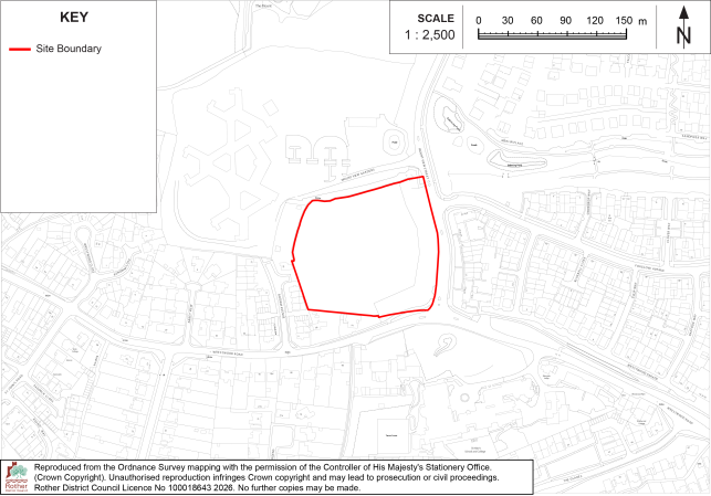
The site is allocated for residential-led mixed use development comprising:
- Some 66 new dwellings;
- Some 540 sqm retail floorspace.
Development on this site must:
- Provide a policy-compliant amount of on-site affordable housing in line with policy HOU2 of the Rother Local Plan;
- Provide a gateway street edge to Mount View Street to include apartments fronting the street above retail units providing local shop(s);
- Retain and protect existing habitats and hedgerows where possible, with compensatory planting where loss is unavoidable;
- Deliver a comprehensive landscaping scheme, including mature planting, to establish a strong landscape structure throughout the site;
- Protect the amenity of the occupiers of adjacent properties;
- Secure long-term conservation of the landscape and biodiversity enhancements through a Landscape and Ecological Management Plan;
- Design and implement appropriate flood risk and include no built development in the northern part of the site which is shown to be at risk of surface water flooding;
- Incorporate and implement ecological mitigation and enhancements;
- Contribute to bus service and infrastructure improvements as required.
10.308Land at Worsham Farm (West) originally formed part of the wider Worsham Farm strategic mixed-use development, permitted under outline consent RR/2015/1760/P. However, this site was subsequently sold to a third party, and the Reserved Matters, pursuant to the outline permission, was not sought or approved. The site has now become available again for a residential-led development and remains suitable in principle for this use.
10.309The original outline consent anticipated around 50 dwellings in this location, together with retail space to provide local shops fronting Mount View Street. However, the re-allocation provides an opportunity to increaser the density on this relatively unconstrained site. It is anticipated that smaller dwellings will be appropriate, with the retail unit(s) provided underneath a flatted scheme. These will need to be located to avoid the areas in the northeastern corner of the site that are at risk of surface water flooding.
10.310If, prior to this site coming forward, retail unit(s) to provide a local shop are secured on an alternative site within reasonable walking distance of this site, this aspect of the allocation could potentially fall away and a wholly residential scheme considered.
Policy BX45: Plot 7, Bexhill Enterprise Park, Mount View Street Comment
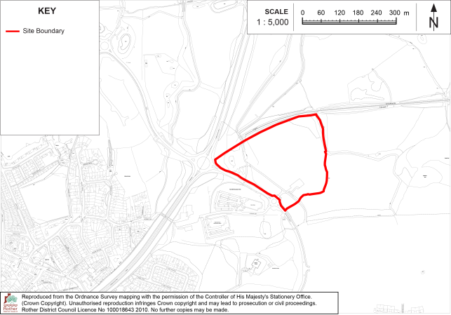
The site is allocated for employment development comprising some 26,000 sqm new employment floorspace (use class E(g), B2 or B8).
Development on this site must:
- Accord with Policy BX26 of this Plan (North Bexhill Growth Area – Infrastructure Policy) in terms of including direct provision of and/ or financial contributions towards all necessary infrastructure to serve the development along with development in the wider North Bexhill area, including contributions towards bus services;
- Include vehicular access from Mount View Street and necessary improvements to infrastructure to meet the requirements of the Highway Authority;
- Include improved active travel routes to link to Mount View Street and nearby residential areas;
- Provide an active frontage onto Mount View Street;
- Include sensitively designed, car and cycle parking to be integrated with green infrastructure and SUDS features;
- Include provision to allow reasonable use of car and cycle parking spaces by visitors to the adjacent Combe Valley Countryside Park;
- Maintain and enhance the existing public right of way within the site to provide an attractive and accessible active travel entrance to the Combe Valley Countryside Park;
- Include no built development in the parts of the site which are shown to be at risk of surface water flooding;
- Deliver a comprehensive landscaping scheme, including mature planting, to establish a strong landscape structure throughout the site.
- Include provision for the retention and future management of a buffer zone of semi-natural habitat, at least 15 metres wide on the northern and eastern boundaries of the site, between the edge of development and the Priority Habitat and Local Wildlife Site;
- Retain and enhance the existing hedgerows, trees and woodland within the site and on the site boundaries where possible, except for any short sections of hedgerow that have to be removed to facilitate access, which should be minimised as far as possible;
- Retain and protect the existing pond to the west of the site and provide an appropriate buffer to any built development including roadways.
10.311This is a sloping field north of Mount View Street, previously in agricultural use and currently in temporary use in connection with the construction of the adjacent housing development at Worsham Farm. It has a site area of 6.5 hectares and could accommodate some 26,000 sqm employment floorspace[8].
10.312This forms part of a larger site, extending to the south-west, which previously had outline planning permission for employment floorspace, and which was also allocated for business use through the Rother District Local Plan 2006 (policy no longer extant). While a section of the permitted site was subject to reserved matters approval and has been constructed (an office building on the southern side of Mount View Street), this larger area was not subject to a further application, and the outline permission has now expired. However, there have been no significant changes in circumstances which would mean the site is no longer suitable for some form of employment development. However, it is considered appropriate and beneficial to broaden the allocated use to include all of the employment use classes, as the originally anticipated use as offices/ light industrial has not come forward in the considerable time period since it was first allocated, and there is a need for B2 and B8 uses within the plan area, as well as E(g) uses.
10.313The landowner has proposed the site for retail use, namely an out-of-town retail park. While some form of retail use could potentially form part of a sustainable community at North Bexhill, national planning policy requires that retail development and other main town centre uses are ordinarily directed to town centre areas. Therefore, comprehensive further evidence and study produced by the landowner and assessed by the Council would be required to support any out-of-town retail park, including an assessment of the impact on Bexhill and Hastings town centres.
10.314 It is important that development at this site is designed to encourage access by active travel (including the public rights of way network) and public transport, car parking areas are not dominant, and an active frontage is provided to Mount View Street.
10.315 A Local Wildlife Site adjoins the site on its northern boundary, containing Priority Habitat linking to ancient woodland further north. Furthermore, the northern part of the site, together with adjacent land to the north and east, is identified as an Area that Could Become of Importance to Biodiversity (ACIB) in the Local Nature Recovery Strategy (LNRS). Development will need to accord with Policies ENV7-10 and have regard to the Measures and Priorities within the LNRS. The site layout and detailed design will need to be carefully designed, informed by landscape and ecological assessment work, to ensure the inclusion of appropriate buffers, additional habitat creation and the avoidance of impacts to the adjacent woodland, from, for example, lighting and disturbance.
10.316There are a pond and a wastewater pumping station in the south-western corner of the site which would need to be retained. There are areas of the site at risk of surface water flooding, primarily associated with the pond to the west but also present along the northern and eastern boundaries.
10.317 The site is also adjacent to the Combe Valley Countryside Park, and a public footpath passes through its western section. It provides an opportunity for improved access to, and reasonable parking provision for users of, the Countryside Park, as set out in the policy.
Policy BX46: Bexhill Enterprise Park – Escarpment Site B, Glovers End Comment
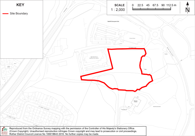
The site is allocated for employment development comprising some 5,800 sqm new employment floorspace (use class E(g), B2 or B8).
Development on this site must:
- Provide associated roads, cycleways, footways and connections to adjoining Public Rights of Way;
- Submit and implement a Travel Plan to promote sustainable transport modes, including provision for (and contributions towards) bus services;
- Retain and protect the woodland in the southern part of the site and include an appropriate buffer to the edge of any development;
- Deliver a comprehensive landscaping scheme, including mature planting, to establish a strong landscape structure throughout the site;
- Design and implement appropriate flood risk management and Sustainable Drainage Systems (SuDS).
10.318This is a vacant, grassed, site on the southern side of Mount View Street. The northern section is relatively level while the southern section slopes up to join an area of woodland further south. It has a site area of 1.45 hectares and could accommodate some 5,800 sqm employment floorspace[9].
10.319The northern part of the site has detailed planning permission for the construction of a three-storey office building with associated parking and landscaping (RR/2017/963/P). The permission included a separate office building on adjoining land to the west, which has now been constructed, thereby implementing the planning permission.
10.320The southern part of the site does not benefit from planning permission, although it offers an opportunity to potentially provide additional employment floorspace. This will need to be carefully designed having regard to the sloping nature of this part of the site and the need to protect the adjoining woodland, which is also a Priority Habitat and identified as an Area that Could Become of Importance to Biodiversity (ACIB) in the Local Nature Recovery Strategy (LNRS). Development will need to accord with Policies ENV7-10 and have regard to the Measures and Priorities within the LNRS. The site layout and detailed design will need to be carefully designed to avoid impacts to the adjacent woodland, from, for example, lighting and disturbance.
10.321The allocation is expected to deliver a high-quality, sustainable employment site that contributes significantly to the district’s economic objectives while protecting and enhancing the natural and historic environment.
Policy BX47: Land west of Bexhill Innovation Park, Glovers End Comment
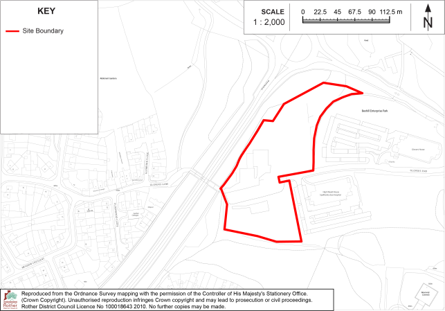
The site is allocated for employment development comprising some 6,400 sqm new employment floorspace (use class E(g), B2 or B8).
Development on this site must:
- Provide associated roads, cycleways, footways and connections to adjoining Public Rights of Way, including enhanced pedestrian and cycle connections between Glovers End, Glovers Lane and the Combe Valley Countryside Park via the public footbridge and Byway (Bexhill 81);
- Submit and implement a Travel Plan to promote sustainable transport modes, including provision for bus services;
- Retain and protect the trees on the western boundary of the site and include an appropriate buffer to the edge of any development;
- Deliver a comprehensive landscaping scheme, including mature planting, to establish a strong landscape structure throughout the site;
- Include building assessment and recording (including architectural/ historical analysis) of the post-medieval barn within the site, and the retention and appropriate enhancement of the barn as part of the development;
- Design and implement appropriate flood risk management and include no built development in the parts of the site which are at risk of surface water flooding.
10.318This is a vacant, grassed site on the southern side of the junction of Mount View Street and Combe Valley Way. It has a site area of 1.6 hectares and could accommodate some 6,400 sqm employment floorspace[10].
10.319The site forms part of a larger site that was previously allocated for business use through the Rother District Local Plan 2006 (no longer extant), and which has also been subject to outline planning permission for business use (now expired). The northern part of the site also previously had planning permission for a public house and hotel, but this was not implemented.
10.320The site is raised up above the level of these roads and is accessed via Glovers End to the east. It previously contained a farmhouse associated with the former Glovers Farm, but this was destroyed by fire. An historic barn remains within the site and should be retained as part of the development.
10.321The site adjoins an Area that Could Become of Importance to Biodiversity (ACIB), as identified in the Local Nature Recovery Strategy (LNRS). Development will need to have regard to the Measures and Priorities within the LNRS.
10.322 The allocation is expected to deliver a high-quality, sustainable employment site that contributes significantly to the district’s economic objectives while protecting and enhancing the natural and historic environment. This includes avoiding the areas of the site at risk of surface water flooding.
[2] Refer to the latest version of East Sussex County Council’s guidance on Parking at New Developments.
[3] e.g. National Design Guide, National Model Design Code, Building for a Healthy Life.
[4] In accordance with Historic England’s “The Setting of Heritage Assets – Good Practice Advice in Planning Note 3” and “National Farmstead Assessment Framework”.
[5] Given the uncertainty in their delivery, these dwelling numbers are not included in the Local Plan’s housing requirement figure set out in Chapter 2.
[6] In accordance with Historic England’s “The Setting of Heritage Assets – Good Practice Advice in Planning Note 3” and “National Farmstead Assessment Framework”.
[7] HEDNA Update (2026)
[8] Calculated using a Plot Ratio of 0.4 for employment floorspace, further to the HEDNA Update (2026).
[9] Calculated using a Plot Ratio of 0.4 for employment floorspace, further to the HEDNA Update (2026).
[10] Calculated using a Plot Ratio of 0.4 for employment floorspace, further to the HEDNA Update (2026).
