
Rother Local Plan 2025-2042 Regulation 19 (pre-submission) version September 2026
Chapter 1: Introduction – Planning for Rother’s Future Comment
About the Rother Local Plan
Background
1.1The Rother Local Plan sets out a vision for the future of the district along with the planning, land-use and delivery framework to achieve this vision through to 2042. It has been prepared to ensure there is a clear framework in place to deliver sustainable development locally, in a way that enhances the wellbeing of our communities and respects the distinctive character and special qualities of the district.
1.2 Rother is a special, but highly environmentally constrained district, with some 83% of its land area lying within the High Weald National Landscape and a further 7% containing nationally and internationally protected habitat sites. National Landscapes have the highest status of protection in relation to landscape and scenic beauty. Rother, like all relevant Authorities, has a legal duty to seek to further the statutory purpose of National Landscapes, which is “to conserve and enhance the natural beauty of the area”. This duty has a significant impact on the type and amount of development that can be appropriately accommodated within the district, as reflected in the Local Plan.
1.3The Local Plan is underpinned by and will help to support Rother’s Council Plan[1]. This sets out the overarching priorities of the Council along with key actions to deliver on these. It includes the vision and three key themes of:
- ‘A Thriving Local Economy’ for the district with diverse, flexible, well-paid local employment and skills opportunities;
- For people to be enabled to ‘Live Well Locally’ within safer and fairer communities; and
- Rother to be recognised as being ‘Green to the Core’ in leading the response to the climate and biodiversity emergencies as well as protecting the historic and natural environment.
1.4The Local Plan is the main document used by the Council to determine planning applications. Once adopted, the new Local Plan will replace the Rother Core Strategy (2014) and Development and Site Allocations Local Plan (2019). The Affordable Housing Supplementary Planning Document (2006) will also be deleted.
1.5The Government has committed to a process of local government reorganisation. This will lead to significant changes, including the creation of a unitary council that will replace Rother District Council. Whilst many details are still to be confirmed, this will affect how local councils operate and services are delivered in East Sussex and elsewhere in the country. Amidst this backdrop of change, the Local Plan will help to ensure that the best interests of Rother’s people, places and environment continue to remain at the heart of local planning decisions.
The planning framework
1.6Rother’s Local Plan is prepared within the context of a planning framework set by the Government which provides for a ‘plan-led’ system in England. At its core, this involves identifying what type of development is needed and where, as well as which areas need to be protected or enhanced. Local plans form the main basis for planning decisions to ensure that new development (including supporting infrastructure) is coordinated, appropriately located and well-designed. In short, the plan-led system provides certainty about the expected outcomes of the planning and development process and helps to avoid ad-hoc or discretionary decision-making.
1.7The Planning and Compulsory Purchase Act 2004 is primary legislation that provides the main basis for the plan-led system. It is supported by secondary legislation, including the Town and Country Planning (Local Planning) (England) Regulations 2012 (as amended), which provide further details on the process for the Council to prepare and adopt the Local Plan and other supporting documents.
1.8The Local Plan is required to be consistent with national policy, including the National Planning Policy Framework (NPPF). The NPPF sets out the Government’s planning policies for England and how they should be applied, with the main objective of delivering sustainable development. It includes directions for the preparation of local plans and is also a material consideration in planning decisions. The NPPF is supported by the companion Planning Practice Guidance (PPG).
A new planning system
1.9The Levelling Up and Regeneration Act 2023 (LURA) paves the way for a new planning system in England (whist retaining the principles of the plan-led system). It revises the parameters for plan-making to speed up the overall process and to help ensure local authorities have up-to-date plans. The Planning and Infrastructure Act 2025 follows on from the LURA. Its main aims are to streamline the planning system and to facilitate joint working across administrative boundaries to address development and infrastructure needs. This includes the production of new sub-regional Spatial Development Strategies, which set the framework for and guide the preparation of Local Plans.
1.10The Town and Country Planning (Local Planning) (England) Regulations 2026 establish the updated legal framework for local planning in England. They replace the 2012 Regulations and give effect to new planning system. In addition, the Government published a new NPPF in August 2026.
1.11The Government has set a deadline for local planning authorities to submit their Local Plans to the Secretary of State for examination by December 2026, in order for these to be assessed under the provisions of the ‘legacy’ planning system[2]; after which Local Plans must be prepared and examined in accordance with the new planning system. For the avoidance of doubt, this Local Plan has been produced under the legacy system.
1.12Where the NPPF is cited in this Local Plan, this refers to the NPPF published in December 2024 unless otherwise specified.
The plan period
1.13The NPPF requires the Local Plan to include strategic policies that look ahead over a period of at least 15-years from the plan’s adoption.[3] The plan period has been set considering the plan’s timetable for production[4] and expected date of adoption, subject to it being found sound and legally compliant at Examination in Public. The plan period for the Rother Local Plan is the 17-year period from 1st April 2025 to 31st March 2042.
How to use the Local Plan
1.14The Local Plan forms part of Rother’s statutory Development Plan, together with the Minerals and Waste Plans prepared by East Sussex County Council and ‘made’ Neighbourhood Plans. It is law that planning applications must be determined in accordance with the Development Plan, unless material considerations indicate otherwise.[5]
Structure
1.15For ease of use, the Local Plan is organised into chapters covering a range of planning policy topics and matters. The structure of the Local Plan and the main contents of each chapter is set out in Figure 1.1 below. The order of the strategic priorities, topics and policies in the plan is not a reflection of their weight or importance. Planning policies are clearly indicated throughout by text boxes along with policy names and reference numbers.
1.16A separate Policies Map has been prepared and sits alongside the Local Plan. It illustrates the development policies that apply to different geographical areas in the district. The Policies Map has been prepared as a digital map and is available to view online at the Council’s Local Plan webpage.
Figure 1.1: Rother Local Plan structure
|
Chapter 1 |
Introduction Provides background information on the Local Plan and a profile of Rother. |
|
Chapter 2 |
Vision, priorities, objectives and the spatial strategy Sets out the future vision for Rother district, the key priorities and objectives for the Local Plan, and the spatial strategy (the land-use and development framework). |
|
Chapters 3 to 7 |
Thematic topic area policies Planning policies to ensure that new development is appropriately located, designed and managed. These cover a range of thematic topic areas organised on the following headings:
|
|
Chapter 8 |
Monitoring framework |
|
Chapter 9 |
Area and site allocation policies Planning policies for specific areas and sites, which are organised by five geographic sub-areas of the district. Site allocations set site-specific requirements for the use of land and design of development. |
|
Appendices |
1.17Whilst the chapters and planning policies individually cover specific planning matters, for planning applications and decisions the Local Plan must be read as a whole, considering all relevant policies.
Strategic and non-strategic policies
1.18 The NPPF requires the Local Plan to include strategic policies that set out an overall strategy for the pattern, scale and design quality of places and make sufficient provision for identified development needs. As noted above, strategic policies should cover a minimum period of 15-years from the plan’s adoption. Further, the NPPF directs that Local Plans clearly distinguish between strategic and non-strategic policies. Therefore, each policy in this Local Plan denotes which type it is. For reference, a schedule of strategic policies is also included in Appendix 1.
Neighbourhood planning
1.19Neighbourhood planning provides opportunities for local communities to prepare Neighbourhood Development Plans, or Neighbourhood Plans, which set out a shared vision for their local area and policies to help facilitate sustainable development. There are currently 9 such plans in the district that have been ‘made’ (adopted), as listed below:
- Battle CP Neighbourhood Plan
- Burwash Neighbourhood Plan
- Crowhurst Neighbourhood Plan
- Hurst Green Neighbourhood Plan
- Peasmarsh Neighbourhood Plan
- Rye Neighbourhood Plan
- Salehurst & Robertsbridge Neighbourhood Plan
- Sedlescombe Neighbourhood Plan
- Ticehurst Neighbourhood Plan
1.20Rother District Council will continue to work positively with parish and town councils in the district during the preparation and review of their Neighbourhood Plans. Each of the Neighbourhood Plans currently has an “end date” of 2028 and, with the exception of Rye, has not commenced a Review to extend the plan period. Therefore, this Local Plan identifies sites to meet the housing requirement in each of the neighbourhood planning areas, with the exception of Rye (as set out at Policy SS6: Neighbourhood Plans & Parish Priority Statements). This does not, of course, preclude the identification of additional site allocations through the neighbourhood plan process.
1.21An alternative option for parish and town councils is to prepare a “Parish Priority Statement”, as further detailed at paragraph 2.88. There is currently[6] one Parish Priority Statement in Rother, for Catsfield.
Useful information
1.22Where the term ‘major development’ is used in the Local Plan this is defined in accordance with planning legislation[7] unless otherwise specified, i.e. for housing, development where 10 or more homes will be provided, or the site has an area of 0.5 hectares or more. For non-residential development it means additional floorspace of 1,000 square metres or more, or a site of 1 hectare or more. In the High Weald National Landscape, the NPPF sets out provisions and considerations for what constitutes major development for the specific purposes of NPPF Paragraphs 190 and 191 only[8].
How the Local Plan has been prepared
1.23The procedures and requirements for preparing a Local Plan are set out by planning legislation and the NPPF. There are several key stages involved in the plan-making process, including multiple rounds of formal (statutory) public consultation before a draft plan can be submitted to the Secretary of State for Examination in Public.
1.24The Council has carried out extensive engagement and consultation with key stakeholders throughout the preparation of the Local Plan. This includes with Government bodies, neighbouring and other local authorities, infrastructure providers, special interest groups, businesses, landowners and developers, parish councils, local communities and community groups, local residents, and the wider public. Feedback received during this process has been used to inform the preparation of the plan. Further details of the consultation process and outcomes are set out in the Rother Local Plan: Consultation Statement.[9]
Evidence base
1.25The Local Plan is informed by a robust and proportionate evidence base. This is made up of technical studies, assessments and other supporting documents. The evidence base includes documents that have been prepared by the Council (either directly or by commissioning specialist consultants) and other organisations, including Government bodies. The evidence base helps to ensure that the policies in the Local Plan are appropriate and justified, taking into account the latest available information.
Impact Assessments
1.26There are several assessments that are legally required to be undertaken during the preparation of the Local Plan, as follows:
- Strategic Environmental Assessment (SEA) / Sustainability Appraisal (SA) – An assessment of the predicted environmental, social and economic effects of the Local Plan. It is carried out as an iterative process and used to inform the plan’s production. A Health Impact Assessment (HIA) has been incorporated into the SA.[10]
- Habitats Regulations Assessment (HRA) – An assessment to determine whether the Local Plan will adversely impact on protected habitats and species.[11]
- Equalities Impact Assessment (EqIA) – An assessment to consider the impact on groups defined by the protected characteristics under the Equality Act 2010.
1.27These assessments have been carried out in line with the statutory requirements and form part of the Local Plan evidence base.
Portrait of Rother
1.28The following section provides an overview of the district and its population. It is intended to draw out some of the key features, characteristics and trends that are of particular interest to the preparation of the Local Plan. Further information about the district is set out elsewhere in the Local Plan as well as the supporting evidence base.
Location
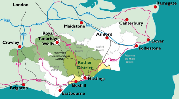
1.29Rother is located in East Sussex, in the South East of England along the south coast. The district covers roughly 200 square miles by area, with a coastline spanning some 25 miles. It is bordered by the authority areas of Wealden, Tunbridge Wells, Ashford, Folkestone & Hythe, and it surrounds Hastings.
Geography and settlement pattern
1.30Rother’s geography is characterised by its coastal and predominantly rural setting, with a variety of environmental assets that provide both ecological and amenity value. The coastline features shingle beaches, nature reserves and low-lying marshes. Inland, there are rivers and river valleys together with expanses of agricultural land, fields, woodlands and rolling hills. Most of the district, some 83 per cent of its total area, is within the High Weald National Landscape, recognised as an Area of Outstanding Natural Beauty and one of the best remaining examples of a medieval landscape in Northern Europe. Some 7 per cent of the district features internationally or nationally protected habitats sites. These include the Pevensey Levels, straddling the district’s south-western boundary, and the Dungeness Complex of Habitats Sites on the south-eastern boundary.
1.31Rother has a characteristically rural settlement pattern. The principal urban area is Bexhill-on-Sea, with the historic market towns of Battle and Rye being secondary centres and also key focal points of community and commercial activity. There are villages dispersed throughout the district, often situated along historical transport routes.
1.32The major trunk roads are the north-south A21 London to Hastings road, which cuts through the district, and the A259 coastal route running east-west. In terms of rail, Rother is served by mainline National Rail routes providing connections across East Sussex, Kent and onwards toward London, including High Speed 1 via Ashford. The heritage “Rother Valley” railway provides a leisure route in the north-eastern part of the district.
Heritage
1.33Rother has a rich historic environment shaped by its built heritage, landscape character and settlement pattern. The district contains a wide range of designated heritage assets including over 2,000 listed buildings together with Conservation Areas, scheduled monuments, registered parks and gardens, and the renowned historic battlefield at Battle. Its historic places include the market towns of Battle and Rye, the Victorian and Edwardian seaside town of Bexhill-on-Sea, the planned medieval town of Winchelsea, and numerous villages, hamlets and dispersed farmsteads across the High Weald. The form, materials and appearance of settlements and buildings reflect both regional and local characteristics. This heritage contributes to Rother’s sense of place, cultural identity and local distinctiveness.
Population
1.34In 2024, Rother’s population was 96,133 people, comprising roughly 52 per cent females and 48 per cent males by gender. Rother has an older than average, and aging, population, with a median age of 53; the highest in the South East. People aged 65 and older make up one-third of the population. However, there are also many families and younger people, with those under the age of 16 accounting for 15 per cent of the population. In terms of ethnicity, 2021 Census data indicates that some 95 per cent of the population is white.[12]
1.35The life expectancy of someone born in Rother is 86 years (for females) and 83 years (for males). These figures are slightly above national averages and have improved slightly over recent years. Dementia is the leading cause of death, followed by ischaemic heart diseases, although the most common causes of premature death (under 75 years), are lung cancer and heart disease[13]. Physical activity rates for adults in Rother are comparable to averages in the South East and the country, however for children aged 5 to 16 they compare less favourably, with activity rates amongst the lowest in the South East.[14]
Deprivation
1.36Whilst the South East is generally more affluent than other parts of the country, this is not necessarily the case for Rother. The district is in the 40 per cent most deprived authority areas in England. The 2019 Index of Multiple Deprivation gives an overall rank for Rother of 135 out of 317 English authorities (with 1 ranked as the most deprived). Rother has seen a slight improvement since 2010, when it ranked at 132. Not all areas in Rother experience deprivation and it varies across the district, with the most deprived areas being Sidley (Bexhill), Central Bexhill Ward, Eastern Rother Ward, and the northwest of Rye Town Ward.
Economy and workforce
1.37Rother has around 4,600 businesses, with small and micro businesses forming a fundamental part of the Rother economy, with 88 per cent of businesses employing less than 9 people. The district’s employment base includes a strong visitor economy and local service component, with accommodation and food services and wholesale and retail. Rother also has a notable concentration of financial and insurance employment, alongside professional, scientific and technical activities, construction, health, education and land-based activity.
1.38Tourism is noteworthy as some 5,800 jobs are in Rother are supported by the visitor economy and it is estimated that 21.6 per cent of the district’s population is employed directly or indirectly as a result of tourism. With this employment profile, average salaries in Rother, at £35,320, are approximately £5,000 lower than for England at £40,339.[15]
1.39In terms of the labour supply and workforce, the latest data shows that employment rates are below the national average, along with a higher proportion of those in Rother working part-time. Further, one-quarter of the district’s working age population are economically inactive (not in employment and not actively seeking work). The proportion of those in Rother seeking Universal Credit or Job Seekers Allowance (3.2 per cent) is the same as the South East, and lower than for East Sussex (3.6 per cent). Some 38 per cent of the Rother working age population have a degree or higher, below the national average of 43 per cent, and 11 per cent have no qualifications.[16]
Housing
1.40Rother has a much higher proportion of owner occupancy and a much lower proportion of social housing compared to the national, regional and county averages. According to the 2021 Census, some 73 per cent of households are owner-occupiers.[17] Planning monitoring data indicates that new housing is largely for market sale tenure, with comparably less affordable housing products being delivered.[18] In 2022, there were over 2,000 households on Rother’s housing register, and evidence points to continued need for affordable housing in the future.[19]
1.41In 2024, the ratio of the median house price to the median gross annual income was 11.07 (workplace based). In other words, the average income earner employed in Rother needs 11 times their annual salary to buy an average priced property in Rother. The ratio of median house price to median gross annual workplace-based earnings in Rother has been higher than the England ratio over the last decade.
Climate change
1.42Carbon dioxide emissions have been decreasing across Rother since 2005. This is mostly due to the decarbonisation of the national grid. In 2022, Rother’s territorial greenhouse gas emissions were 411.2 kilotonnes CO2 equivalent (ktCO2e), 12.4% lower than 2021 and 10.5% lower than 2019. Emissions rose between 2020 and 2021 across all parts of the UK, including Rother, owing mainly to an increase in industrial emissions and post-pandemic transport emissions. Transport emissions have remained relatively consistent in recent years. In 2022, three sectors were responsible for over 90 per cent of emissions: transport (40 per cent), domestic (34 per cent), and industrial (17 per cent).[20]
Key strategic issues
1.43The following strategic planning issues for Rother are listed below. These have been informed by the evidence base, the direction provided by the NPPF on plan-making, engagement with key stakeholders and public consultation feedback. The intention here is to highlight the key issues at the strategic, district-level that are of particular importance to the preparation of the Local Plan and are therefore proportionate to the scope of it. This section does not necessarily, nor does it set out to, identify all of the issues that are or may be relevant to the district or the local areas within it.
1.44The overarching strategic issue that cuts across those listed below is the need to accommodate growth in a sustainable way. There is a clear direction from the Government for local authorities to prepare Local Plans that address identified development needs, particularly to facilitate a significant boost in housing supply and delivery. Therefore, it is important that growth is carefully managed and coordinated in a way that respects local character and does not result in adverse impacts on communities and the environment – and indeed secures lasting improvements and benefits - in Rother, cumulatively across East Sussex and beyond.
1.45Within the overall context of delivering sustainable development, the key strategic issues for the Local Plan are, in no particular order:
- Responding to the Council’s declared Climate Emergency to set out local approaches for adapting to and mitigating the effects of global climate change, including by significantly reducing carbon emissions and effectively managing and reducing flood risk from all sources.
- Conserving and enhancing the natural environment (including protected habitats and species), delivering net gains for biodiversity, and enhancing the quality of the network of blue and green infrastructure, including the coastline and coastal areas.
- Protecting the character and quality of countryside, landscapes and dark skies, including by seeking to further the statutory purpose of the High Weald National Landscape, together with conserving and enhancing heritage assets and their setting in a way that reinforces and enhances Rother’s local distinctiveness,
- Meeting Rother’s identified needs for housing (including affordable housing, specialist housing, and accommodation for the gypsy, traveller and travelling showpeople community), along with needs for employment and commercial uses.
- Supporting businesses, cultural development and securing economic improvement, both in urban and rural areas of the district, in the context of wider national economic cycles and challenges.
- Improving the physical and mental health and wellbeing of the population and significantly reducing inequalities and deprivation by addressing the key determinants of these. This includes but is not limited to barriers and opportunities for people of all ages and abilities to live healthy and active lifestyles; good access to housing and a range of high-quality local jobs, training and education opportunities, as well as to local services and facilities, including sports and recreation; reducing and mitigating the population’s exposure to all forms of pollution.
- Planning positively to meet the needs of people of all ages and abilities, including the needs of older people and an ageing population.
- Addressing deficiencies in infrastructure and securing the timely, coordinated delivery of new and improved infrastructure to support local communities and areas, particularly as new development comes forward.
[1] Our Council Plan 2025-2029, Rother District Council.
[2] Principally as set by the Town and Country Planning (Local Planning) (England) Regulations 2012 (as amended).
[3] NPPF (2024). Paragraph 22.
[4] Local Development Scheme, Rother District Council.
[5] As set out by Section 70(2) of the Town and Country Planning Act 1990 and section 38(6) of the Planning and Compulsory Purchase Act 2004.
[6] As of September 2026
[7] Development Management Procedure (England) Order 2015 and the Town and Country Planning Act 1990 (as amended)
[8] NPPF (2024), paragraph 189-190.
[9] This is the Consultation Statement prepared in accordance with Regulation 22(1)(c) of the Town and Country Planning (Local Planning) (England) Regulations 2012, as amended, as well as Interim Consultation Statements published during the plan’s preparation.
[10] The Health Impact Assessment process has been informed by joint working with the East Sussex County Council Public Health Team.
[11] As designated under European Union Council Directive on the conservation of wild birds (79/409/ EEC) 1992, European Union Council Directive on the conservation of natural habitats and of wild fauna and flora (92/43/EEC) 1992 and Ramsar Convention on wetlands of international importance.
[12] Local Indicators for Rother, E07000064, Office for National Statistics, 2024.
[13] Rother Joint Strategic Needs Assessment 2024.
[14] State of Rother 2025, Rother District Council.
[15] Compiled from State of Rother 2025, Rother District Council and Rother Tourism and Visitor Accommodation Study, 2026.
[16] State of Rother 2025, Rother District Council.
[17] State of Rother 2025, Rother District Council.
[18] Authority Monitoring Reports, Rother District Council.
[19] Housing and Economic Development Needs Assessment Update.
[20] State of Rother 2025, Rother District Council.
