Rother Local Plan 2020-2040 (Regulation 18)
11. Environmental Management
(1) Proposed Policy ENV1: Coastal, Water and Flood Risk Management
Policy Status:
Strategic
New Policy?
Yes
Overall Priorities:
Green to the Core
Policy Wording:
The effective management of the coast and water, as well as the risks posed by flooding, will be achieved through:
- Ensuring that new development does not have an adverse effect on the water quality and potential yield of water resources, in line with the objectives of the South East River Basin Management Plan, including reference to groundwater 'source protection zones';
- Ensuring that new development does not adversely impact any Ordinary Watercourse, Main River or flood and sea defences, as defined through The Environmental Permitting (England and Wales) Regulations 2016 (as amended), including through the use of buffer zones to the edge of new developments, which is also controlled through byelaw margins by the Environment Agency and Internal Drainage Boards.
The Council will seek opportunities, on a site-by-site basis, and on the advice of statutory consultees, such as in areas at risk of flooding now or in the future, to increase the buffer distances defined in The Environmental Permitting (England and Wales) Regulations 2016 (as amended) to 'make space for water', allowing additional capacity to accommodate climate change;
- If development is, exceptionally, accepted in flood risk areas, consideration is paid to its layout and form to minimise development at risk from flooding now and in the future;
- All developments within the catchment area for the Dungeness, Romney Marsh and Rye Bay SPA/ Ramsar or Pevensey Levels SAC/Ramsar should demonstrate:
- agreement by the wastewater provider that modelling demonstrates that there is sufficient capacity within the relevant waste water treatment works for the development to be accommodated without a negative effect on the receiving environment; or
- that the development can be delivered without a negative water quality effect on the Habitats Sites, and the means by which any necessary protection measures will be secured for the lifetime of the development.
- Contributions will be sought for improvements to infrastructure to mitigate against flood risk where it is deemed necessary; and
- Private, non-mains foul drainage systems are not environmentally acceptable within publicly sewered areas. Planning applications must demonstrate that connection to the public sewer is feasible and any mitigating measures necessary to enable a connection must be identified and agreed between the applicant and the sewerage undertaker.
If a non-mains drainage solution is proposed, an applicant must demonstrate that it is not practicable to connect to the public sewer. Sufficient information to understand the potential implications for the water environment of non-mains drainage must be submitted, including the Environment Agency's Foul drainage assessment form (FDA1). The hierarchy of non-mains alternative solutions must be followed:
- package sewage treatment plants (which may be offered to the sewerage undertaker for adoption) where effluent goes through a wetland prior to discharge into the watercourse/ground as that will improve water quality; then
- septic tanks; then
- in the last instance, a cesspool if no other solution is possible.
Explanatory Text:
(1) 11.1 Ensuring that robust and resilient water supplies and wastewater infrastructure is in place is both essential to the district's residents and businesses, and critical to support growth. There are many challenges in place. These include safeguarding water sources from the threat of pollution, reducing usage, and meeting the challenge of climate change.
11.2 To achieve this, Rother must utilise the capacity of existing infrastructure and encourage behavioural changes to enable more efficient use overall. New and improved infrastructure may be needed to serve new development.
(1) 11.3 There are three key documents that expand on water resources within Rother. The South East River Basin District (RBD) River Basin Management Plan was most recently published in 2022. Locally, the two relevant catchments are the Cuckmere and Pevensey Levels and the Rother. The two water companies that operate within the district are South East Water which has a Water Resources Management Plan and Southern Water have a Drainage and Wastewater Management Plan as well as a Water Resources Management Plan as Southern Water are the drainage and wastewater provider across all of Rother.
11.4 Water quality has become a growing issue in Rother. Southern Water has identified through their Drainage and Wastewater Management Plan several known risks and have highlighted concerns in their Baseline Risk and Vulnerability Assessment. Issues such as storm overflows have an impact on water quality within rivers and seas.
11.5 The surface water sources within Rother comprise three reservoirs at Bewl Water, Darwell Reservoir and Powdermill Reservoir. Bewl Water is situated at the northern edge of the district and straddles the adjacent authorities of Tunbridge Wells and Wealden. The reservoir is an important regional resource but is also a significant recreational amenity. Policies relating to the recreational use of Bewl Water, and other water-based recreation, is contained in the Health and Wellbeing chapter within Policy HWB5 (Green and Blue Infrastructure).
11.6 The Government's planning advice on the use of non-mains foul drainage in England is contained within the Planning Practice Guidance (PPG). Both the PPG and the Building Regulations 2010 Approved Document H set out a presumption in favour of connection to the public foul sewer wherever it is reasonable to do so.
(1) 11.7 Before a proposal to use non-mains foul drainage is considered in detail an applicant must demonstrate to Council's satisfaction that it is not practicable to connect to the public sewer. Connection to the sewer may be reasonable where it is more costly than the installation of a private foul sewerage system because of the benefits of connection to the mains foul sewer. Adopted treatment plants would be preferable for any site that is within the catchment of the Pevensey Levels. High nutrient loading will exacerbate the problem with the non-native invasive species, pennywort, which is a challenge to manage and is spreading on the Pevensey Levels.
(1) 11.8 The Council must be satisfied that the applicant has identified the closest potential point of connection to the existing public foul sewerage network.
11.9 The Environment Agency state that problems with the public sewer being at capacity, or other operating problems with the public sewer, are not acceptable reasons for non-connection to a public sewer where this is otherwise reasonable. Where there is a lack of capacity within the public sewerage system, applicants should establish with Southern Water how they can connect their development to the existing network without exacerbating any existing problems.
11.10 If it emerges that an agreement cannot be reached to allow use of the mains foul sewer, then the developer should be aware that the Environment Agency may not be able to grant a permit for a discharge to surface water or groundwater at a later stage. The PPG explains that in such circumstances the scope for phasing development in line with provision of any necessary additional capacity should be explored.
(1) 11.11 Where a connection to the public sewer is not reasonable, the hierarchy of non-mains alternative solutions set out in this policy must be followed. This occurs most frequently in the rural areas of the district. The Council will apply the Environment Agency's advice for local authorities on non-mains drainage from non-major development in the decision-making process. Applicants will also need to comply with the Environment Agency's General Binding Rules on small sewerage discharge to a surface water where relevant. The Environment Agency's foul drainage assessment form (FDA1), which helps in the determination of a planning application that involves non-mains drainage, will be required for such proposals.
Regulation 18 commentary:
11.12 Water companies produce Business Plans which set out their agreed investment plans where they adopt a joint approach to manage the supply and demand of water. To reduce the demand initiatives such as universal metering, tackling leakages, and rainwater harvesting are being explored. These are complemented by investment in new technology and infrastructure.
11.13 Recently, there has been the growing issues around nutrient neutrality. Natural England has defined specific nutrient neutrality areas of concern across the country, which does not include Rother. It is important that development does not add to existing nutrient burdens within a drainage catchment area and does not negatively impact environmentally designated sites. Although Natural England has not designated a nutrient neutrality area within Rother, it is important that developers are aware of its pollutants and runoff impacts and as such, Policy ENV2 on Sustainable Surface Water Drainage aims help address this issue.
Question Box
(23) 184. What are your views on the proposed policy on water, coastal and flood risk management?
(7) 185. Are there any alternatives or additional points the Council should be considering?
(1) Proposed Policy ENV2: Sustainable Surface Water Drainage
Policy Status:
Non-strategic
New Policy?
No. Updated version of DaSA Policy DEN5
Overall Priorities:
Green to the Core
Policy Wording:
For planning permission to be granted, applicants must demonstrate that sustainable drainage is an integral part of the proposed development and its design. In particular:
- drainage should be designed and implemented having regard to the latest local, regional and national guidance. Applicants must also demonstrate that arrangements are in place for ongoing maintenance of Sustainable Drainage Schemes (SuDS) over the lifetime of the development;
- peak run-off rates from development must be the lower of the two following options: either the greenfield rate in terms of volume and flow; or the existing rate/volume of discharge;
- for all development, including outline applications, sufficient space must be given within a site to ensure that the SuDS can be accommodated within the layout of the site;
- for phased development, a Drainage Strategy should be provided which takes a strategic approach to drainage provision across the entire site and incorporates adequate provision for SuDS within each phase;
- SuDS should be designed and implemented wherever possible to be 'multi-functional' and deliver other policy objectives where appropriate, such as: the provision of habitats and support for biodiversity; reinforcing local landscape character; enhancing the design of development; provision of open space/ recreation; promotion of water use efficiency and quality; reducing risks of land instability; and incorporation into any green and blue infrastructure plans;
- at Fairlight Cove, drainage proposals should accord with Policy ENV3 (Land Stability) and Policy ENV4 (Fairlight Cove Coastal Change Management Area);
- new development should utilise opportunities to reduce the causes and impacts of all sources of flooding, ensuring flood risks are not increased elsewhere, that flood risks associated with the construction phase of the development are managed, and that surface water run-off is managed as close to its source as possible;
- all developments should demonstrate all surface water will pass through at least two treatment stages. For development in the hydrological catchment of Pevensey Levels, a minimum of three stages of treatment will be required; and
- any planning application, including in outline, that triggers a Habitats Regulation Assessment (HRA) will need to provide sufficient details of an appropriate surface water drainage scheme to satisfy the HRA.
Further information and guidance on Sustainable Drainage
- East Sussex Sustainable Drainage Systems:
- South East Lead Local Flood Authorities Water. People. Places.
- The SuDS Manual (C753 - hardcopy publication and C753F – free download)
- DEFRA Non-Statutory Technical Standards for Sustainable Drainage Systems (2015)
- RSPB/WWT Sustainable Drainage Systems - Maximising the potential for people and wildlife. A guide for local authorities and developers (2012)
- East Sussex Local Flood Risk Management Strategy
- East Sussex Surface Water Management Plans (for Bexhill, Battle and Rye)
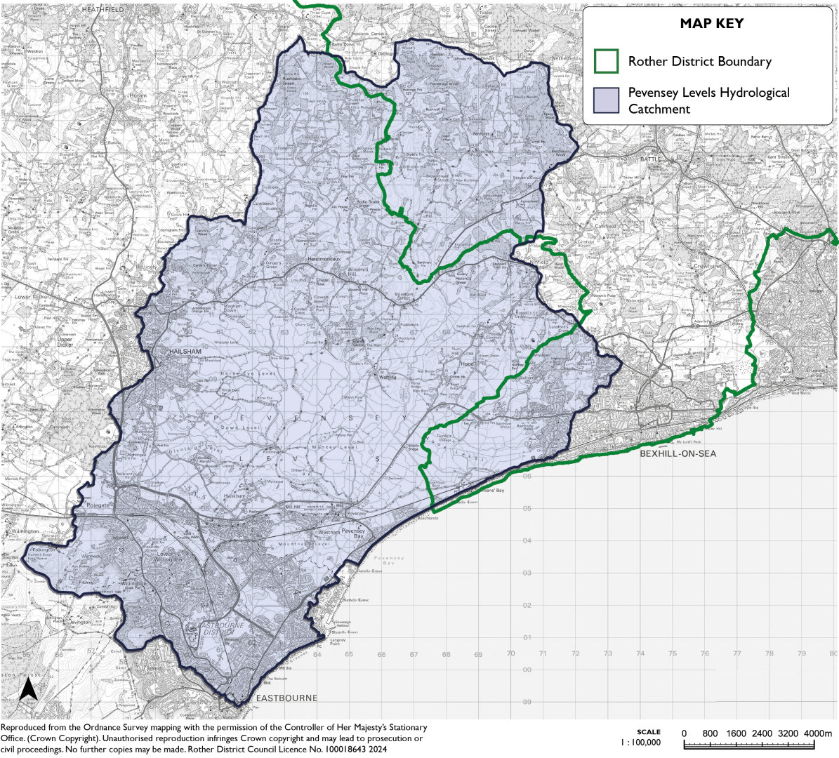
Figure 42: Pevensey Levels Hydrological Catchment Area
Explanatory Text:
11.14 Sustainable drainage systems (SuDS) are a form of drainage solution that manage rainfall and surface water runoff close to where it falls. ESCC are the Lead Local Flood Authority (LLFA) for the whole County and are responsible for managing flooding and SuDS. This is alongside the Environment Agency who are responsible for flood risks from Main Rivers and the coast. Both organisations will be consulted on specific development proposals where required.
11.15 SuDS incorporate a range of features than help to reduce pollution, improve the quality, flows rates, and the volume of water that would otherwise discharge into the natural environment. In any instance, development should consider the drainage hierarchy and first look at infiltration into the ground. Ground conditions will often dictate appropriate SuDS techniques. A ground investigation is likely to be required to assess the suitability of using infiltration measures and assessing the required volume of on-site storage required.
11.16 When looking at the scale of SuDS needed, a development will need to demonstrate that the system proposed is able to cope with the levels of rainfall and runoff as a result of the development. For example, developments proposing high levels of impermeable surfaces will likely need to provide a greater scale of SuDS to mitigate the runoff impacts. The scale required will be linked to the levels of runoff that a greenfield site, i.e. a site that has not been previously built on, or the current runoff rate of the site as it is currently developed. This is to ensure that the risk of flooding as a result of a development does not grow and adversely impact the surrounding area.
11.17 SuDS are required regardless of the pre-existing risk. A SuDS policy is additional to the requirement to address existing areas of flood risk on-site, as set out in national guidance and any other Local Plan policies.
11.18 SuDS can be multi-functional in terms of addressing other Local Plan policy areas, such as helping to improve biodiversity and habitat creation, or creating recreation and amenity spaces. SuDS should be given consideration from the outset in development proposals to ensure enough space is provided. This is both in terms of the drainage capability as well as any other benefits being provided. Phased development will be required to demonstrate that the SuDS being proposed are able to meet the needs of each phase as it is built out.
11.19 The type of SuDS approach should have regard to all relevant factors (flood risk, compatibility for infiltration, groundwater, runoff characteristics, ground stability, topography, soils, geology, contamination issues, existing infrastructure and archaeology) as well as the potential for wider benefits. SuDS should be linked up where possible to achieve greater benefits for water management and wildlife.
11.20 SuDS have various stages of treatment. Guidance from the LLFA states that rainfall should pass through at least two stages of treatment to ensure water quality is improved before being infiltrated or otherwise discharged off site.
11.21 Applicants should submit sufficient information to enable proper consideration of drainage proposals. For major schemes, seeking pre-application advice from the LLFA is strongly recommended. For minor development, the LLFA's 'SuDS Decision Support Tool for Small Scale Development' should be used. In all developments, attenuation measures such as green roofs, rainwater harvesting and permeable paving, should be incorporated to help to reduce runoff.
11.22 Proposals must explain how flood risk impacts will be managed during the construction phase. Also, applicants will need to demonstrate that maintenance measures will be in place for the lifetime of the development[115]. This may be secured by a legal agreement.
11.23 There is a particular need to ensure that development within or near sites that are protected for their ecological importance (the Pevensey Levels and the Dungeness complex of Habitats Sites) is appropriate. This is because poor quality water draining into these sites could have an even greater impact on the environment and ecology. Specific attention is given to the Pevensey Levels hydrological catchment, where more stages of treatment are required, three at a minimum, to mitigate the impact on water quality and quantity. A Habitats Regulation Assessment (which assesses whether a proposal avoids harm to a protected habitat) will be required for development within the Pevensey Levels hydrological catchment and on a case-by-case basis on sites within close proximity to the Dungeness complex of sites.
11.24 The Internal Drainage Boards within the protected areas[116] play an important role in ensuring water is managed appropriately within their catchments. This is achieved through their overall role of reducing flood risk to people and property and managing water levels for agricultural and environmental needs within their defined area.
Regulation 18 commentary:
11.25 There is currently a policy requirement in Policy DEN5 (vii) of the DaSA for surface water runoff rates within the Fairlight and Pett Level Drainage Area (which broadly covers Fairlight, Fairlight Cove, Pett and parts of Cliff End) to be no more than the greenfield rate, in terms of volume and flow. The Council is now proposing to broadly incorporate this requirement for all development.
11.26 In addition, at Fairlight Cove, issues of ground water affect land stability (Policy ENV3 – Land Stability) and cliff erosion and a specific policy is included which restricts the use of soakaways near the cliff face (Policy ENV4 – Fairlight Cove Coastal Change Management Area).
11.27 There is a wider drainage capacity and flooding concern both in the village and downstream at Pett Level, where there is a history of flooding from the Marsham Sewer in periods of wet weather, caused by run-off into the sewer from the Marsham catchment.
11.28 Southern Water has chosen Fairlight as a 'Pathfinder' catchment area due to these issues and has worked with the Parish Council and LLFA. A report was published in January 2023 outlining the issues as well as proposing a range of interventions and investment opportunities to reduce the risks. One action that has been rolled out already is the provision of 'leaky water butts' free of charge, to residents who request one. Each water butt will slow the flow of rainwater entering the sewer, which can become overwhelmed if too much rainwater enters the pipe. 'Leaky water butts' have valves positioned halfway up to allow residents to utilise half of the rainwater captured to wash cars and water gardens.
11.29 The Government stated in January 2023 that SuDS will be mandatory for new development from 2024[117]. In advance of this they will consult on the scope, threshold and process. These changes may affect the Council's proposed policy. The Council will continue working with our neighbouring authorities on cross-boundary issues and to ensure there is a consistency amongst policy requirements.
Question Box
(16) 186. What are your views on the proposed policy on sustainable drainage?
(9) 187. Are there any alternatives or additional points the Council should be considering?
Proposed Policy ENV3: Land Stability
Policy Status:
Non-strategic
New Policy?
No. Updated version of DaSA Policy DEN6
Overall Priorities:
-
Policy Wording:
New development, including residential extensions and alterations, will only be permitted on unstable or potentially unstable land, including former landfill sites and coastal margins, where:
- the nature of the instability has been properly assessed through a full land instability risk assessment report; and
- any remedial measures required to ensure that the development does not add to the instability of the site or surrounding land, are environmentally acceptable, and are normally implemented prior to the commencement of building works.
The use of infiltration to manage surface water will not be allowed, unless a qualified geotechnical engineer has assessed the risk.
Explanatory Text:
11.30 Land instability can be caused by many factors. Rother's coastline is vulnerable due to erosion and more extreme events linked with climate change have led to an increased vulnerability. Local ground conditions, flood events and former land filling or mining can also cause stability issues.
11.31 The PPG is clear that the planning system has an important role in helping to address land stability. This is through including policies in development plans that specifically address the issue by identifying specific areas of concern.
11.32 As a starting point, development should avoid unstable land through the design and layout of the proposal. It is recognised that this may not always be possible and as such, development on unstable land should be designed to be safe.
11.33 Developers may be required to demonstrate that they have investigated risks and where there is likelihood of instability, a full land instability risk assessment report must be submitted with a planning application. This must be undertaken by a competent person to demonstrate the degree of instability, appropriate measures to mitigate those risks, an implementation plan, and future monitoring plan. Further information on the steps developers should take are contained within the Planning Practice Guidance on Land Stability.
Regulation 18 commentary:
11.34 There are several known areas within the district that have land stability issues. The proposed policy addresses these land stability issues on a district-wide basis. Further evidence is needed to devise policies that target specific areas.
11.35 This is the case in Fairlight Cove and the next policy has been created to strengthen its protection.
Question Box
(5) 188. What are your views on the proposed policy on land stability?
(2) 189. Are there any alternatives or additional points the Council should be considering?
(1) 190. Are there areas which you consider require an area specific policy, and if so, what evidence is available?
Proposed Policy ENV4: Fairlight Cove Coastal Change Management Area
Policy Status:
Non-strategic
New Policy?
Yes, but incorporates DaSA DEN6, in relation to Fairlight Cove
Overall Priorities:
Green to the Core
Policy Wording:
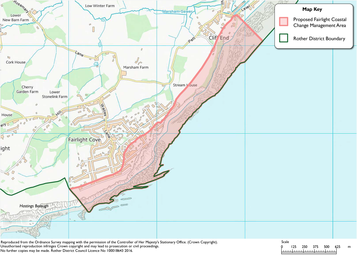
(A) The coastal zone at Fairlight Cove (as shown in both Figure 43 below and on the Local Plan Policies Map) is designated as the Fairlight Cove Coastal Change Management Area.
Permanent new residential development (including through change of use) will not be acceptable in the Fairlight Coastal Change Management Area. Soakaway drains will not be permitted within the Fairlight Cove CCMA.
Any other forms of development will only be considered acceptable if a coastal change vulnerability assessment, which is proportionate to the scale and type of development, demonstrates that:
- The development is necessary in that specific location;
- It will be safe over its planned lifetime[118];
- it will not have an unacceptable impact on coastal change, including the character of the coast (and any designations);
- The development provides wider sustainability benefits; and
- The development does not hinder the creation and maintenance of the King Charles III English Coast Path, National Cycle Network, or any other public rights of way adjacent to or that benefit from views or access to the coast.
The Council may grant a time-limited permission to minimise the longer-term risks to a particular development.
(B) Any proposals for the relocation of an existing development situated within the Coastal Change Management Area to outside of it must relate to a site at risk of loss within 20 years (the short term) of the application being made. The new development must:
- Be located outside and inland of the Coastal Change Management Area, such that the coastal change risks associated with the proposed site are less than the existing site;
- Be of a similar scale and character to the existing development, whilst still having regard for the character of the new location; and
- Include plans to remove and clear any structures on the existing site to make it as safe as possible.
- When relating to residential development, be in a location that is no less sustainable than the location it is currently situated in; or
- When relating to non-residential development, be in a location that is still accessible to the existing coastal community it currently serves.
Development must still accord with all other relevant policies within the Local Plan.
(1) Figure 43: Proposed Fairlight Cove Coastal Change Management Area (CCMA)
Explanatory Text:
11.36 The NPPF defines a Coastal Change Management Area (CCMA) as "an area identified in plans as likely to be affected by physical change to the shoreline through erosion, coastal landslip, permanent inundation or coastal accretion[119]." The NPPF and PPG support local planning authorities in designating CCMAs to ensure inappropriate development is avoided and prospective developers are made aware of the potential risk of coastal change into the future. This is supported by recommendations made by the Council's most recent Strategic Flood Risk Assessment published in 2021.
11.37 The primary evidence needed to designate a CCMA is to identify areas that will be significantly affected by shoreline change over the next 100 years. This far exceeds the timescale that this Local Plan covers but is used in Shoreline Management Plans (SMPs) to define their time period of relevance. Guidance suggests that a CCMA will be needed where an SMP is not actively protecting the coastal line, i.e. where the SMP policy is either Managed Realignment or No Active Intervention. Based on the current 2006 SMP, it is appropriate to designate the CCMA for only the Fairlight Cove coastal area, as shown in Figure 43. The area included is that which is modelled to erode to in 100 years from the SMP's publication, i.e. 2105. The Council will continue to collect evidence after the Regulation 18 consultation stage, to consider if the extent of the CCMA needs to be widened. This will take account of the latest coastal erosion data and mapping along with any revisions to the SMP.
(2) 11.38 The PPG advises that new residential development would not be acceptable in any circumstance within a CCMA as this would increase the number of people at risk in the area. For other forms of development, the suitability of it will consider many factors, including the need for the development to be in that vulnerable location. These forms of development will therefore need to be supported by sufficient information to demonstrate compliance with the proposed policy. The PPG contains detailed information on what uses could be considered acceptable.
(3) 11.39 The other factor that should be considered when designating a CCMA is the relocation of development to a safer area. Due to the locations that would be covered by the CCMA, the scale of affected properties is limited and localised. Nevertheless, the Council is proposing to make provision within the policy to give some weight to a development that was seeking to facilitate an applicant moving away from the CCMA.
11.40 The need for a new development to be built would not automatically be an overriding consideration. Any proposed development would still need to accord with the rest of the policies in the Local Plan to ensure the development is sustainable and appropriate. The proposed policy sets out additional criteria for what the Council would consider to be an acceptable development, based on guidance from the NPPF and in accordance with other key aspects of this Local Plan.
Regulation 18 commentary:
(1) 11.41 The area has had a long history of land instability. Measures were undertaken to manage this through the construction of a rock bund at the sea edge below Sea Road in 1990. In 2007, there was further construction of a rock bund below Rockmead Road, together with slope grading and the installation of slope drainage and deep well pumps in 2007. This was designed to operate for 50 years, consistent with the 'Hold the Line' policy of the Shoreline Management Plan (SMP). A further bund linking these has been in place since 2016.
11.42 While these engineering works control erosion and land loss they do not prevent it. The erosion is also affected by the variable quality of the ground and the impact of ground water. Despite a number of studies of the source of water, the complexity of the geology makes it very difficult to come to clear conclusions. The situation is likely aggravated by the lack of a surface water drainage system at Fairlight, to which Policy ENV3, in part, relates.
(1) 11.43 DASA Policy DEN6 introduced a 50m buffer zone inland from the (then) cliff face and restricted soakaways within it. The supporting text advised that a structural engineer's survey and geo-technical report is required for new development in the zone, to demonstrate that there would be no increase in ground load. This policy approach was based on the recommendations of a report by the East Kent Engineering Partnership in 2015. The report also advised that this buffer zone should be reviewed after 10 years, i.e. 2025.
(1) 11.44 The buffer zone that was designated broadly mirrors the 2006 Shoreline Management Plan long-term erosion line. The proposed policy therefore incorporates this.
11.45 There is a new SMP under preparation and the policy's coverage will be revised if necessary. While a range of intervention measures have been implemented since the 2006 SMP, climate change will have exacerbated the impacts of Rother's coast, therefore the anticipated rate of erosion since 2006 is currently unknown.
11.46 Two Article 4 Directions came into force on 30 September 2023 which apply to 24 residential properties adjacent to the coast at Fairlight Cove. They remove certain 'permitted development rights' which means that certain forms of householder development, such as outbuildings, now require planning permission. This will enable the Council to assess a development against the relevant planning policies. More information on these Article 4 Directions can be found on the Council's website, including a list of the properties affected and the 'permitted development rights' removed.
Question Box
(12) 191. What are your views on the Council's proposed policy on the Fairlight Cove Coastal Change Management Area?
(5) 192. Are there any further areas or additional points the Council should be considering?
193. Are there any other areas of the district that the Council should be considering, and if so, what evidence is available?
(3) Proposed Policy ENV5: Habitats and Species
Policy Status:
Non-strategic
New Policy?
No, updated version of DaSA Policy DEN4
Overall Priorities:
Green to the Core
Policy Wording:
Development proposals must follow the mitigation hierarchy and:
- Conserve, enhance and provide the appropriate management for the biodiversity and ecological value of:
- international, national, regional and local designated sites of biodiversity and geological value;
- Irreplaceable habitats (as defined by the NPPF or as advised by Defra) as well as priority hedgerows;
- Protected Species, and Priority Habitats and Species both within and outside designated sites; and
- Any other ecological feature or network (either green or blue in character) that is deemed appropriate to consider, including areas that could become of importance for biodiversity, as mapped in the Local Nature Recovery Strategy (LNRS).
- Support opportunities for management, restoration, creation and enhancement of habitats in line with the opportunities identified for the Biodiversity Opportunity Areas (BOAs), and/or the Local Nature Recovery Strategy.
- Include a scheme for the provision of integrated bird and bat boxes and bricks, bee bricks and hedgehog highways tailored to habitat conditions existing on or being created on and/or adjoining the site.
- Have regard to Natural England's Green Infrastructure Framework and associated standards and guidance.
- Ensure any proposed flood protection measures have full regard to sensitive areas designated with specific nature conservation and biodiversity interests.
- For Ancient Woodland, create a development buffer zone of at least 15 metres. An impact assessment will be required where any development is proposed within 25 metres of Ancient Woodland to demonstrate that the proposed buffer zone avoids negative effects on the habitat.
- For ancient and veteran trees[120] retain a buffer zone at least 15 times larger than the diameter of the tree, or five metres from the canopy edge, whichever is the largest. An impact assessment will be required where any development is proposed within 10 metres to demonstrate that the proposed buffer zone avoids negative effects on the habitat.
Explanatory Text:
11.47 The biodiversity habitats in Rother are substantial and wide-ranging. There are large areas of internationally designated sites and many nationally important Sites of Special Scientific Interest (SSSIs) which, in total, cover about 9% of the district, as well as some 60 Local Wildlife Sites. Ancient Woodland, which covers 16% of the district (the highest percentage in the South-East) has complex and rare biodiversity because of their undisturbed soil, ground flora and fungi. Many nationally defined[121] Habitats and Species of Principal Importance, referred to herein as Priority Habitats and Species, are also represented. These are often beyond the internationally, nationally and locally designated sites.
11.48 The following sections cover a range of different sites which are broadly covered by the definition of 'International, national and locally designated sites of importance for biodiversity' in the NPPF. It is important to stress that these designations, and therefore this policy, apply to both land-based and marine designations. The Joint Nature Conservation Committee's (JNCC) website holds a range of information and resources on many of these protected sites. They are also summarised in Appendix 3.
Internationally protected sites
11.49 The two internationally important wildlife sites extending into the district are the Pevensey Levels, to the south-west, which is designated as a Ramsar site of international importance as a wetland habitat and as a Special Area of Conservation (SAC); and the Dungeness Complex of Habitats Sites[122], on the eastern side of the district, which are designated for their value for birds and as wetland habitats. The NPPF refers to SACs, SPAs and Ramsar sites as habitats sites.
11.50 The presumption in favour of sustainable development does not apply where a plan or project is likely to have a significant effect on a habitats site, unless an appropriate assessment has concluded that the plan or project will not adversely affect the integrity of the habitats site.
11.51 In relation to the potential impact of tourism and recreation on the Dungeness Complex of Habitats Sites (which were first highlighted as a risk during the Habitats Regulation Assessment of the Core Strategy), the Council produced a Sustainable Access and Recreation Management Strategy (SARMS). Regard will need to be had to Policy ENV6 in relation to SARMS for relevant developments.
Nationally protected sites
11.52 SSSIs are highly protected sites for their wildlife and natural features. As such, they carry a strong presumption against development which would cause harm. Natural England is a statutory consultee for proposals which may affect a SSSI.
11.53 While Areas of Outstanding Natural Beauty (AONBs) are national landscape designations for the purpose of conserving and enhancing the natural beauty, the term 'natural beauty' includes conservation of flora, fauna and geological and physiographical features of an area. Furthermore, some of the key High Weald character features are also Priority Habitats (ghyll woodland, sandstone outcrops, ancient woodland, heathland, wildflower meadows and ponds) which are discussed later below. Therefore, particular consideration should be given to improvements in biodiversity that meet High Weald National Landscape (AONB) objectives.
Irreplaceable habitats
11.54 When determining compliance with this policy, the Council will follow the definition of the NPPF and the advice of Defra. The NPPF does not consider hedgerows in the definition of an irreplaceable habitat. However, the Council feels that considering the legal protection that priority hedgerows carry[123], it is appropriate to regard them alongside other irreplaceable habitats. As such, development will also need to demonstrate that hedgerows are protected and enhanced where necessary.
11.55 For Ancient Woodland and Ancient and Veteran Trees, there is existing standing advice from Natural England and the Forestry Commission. This includes the use of buffer zones. The standing advice is that the zone should be at least 15 metres for Ancient Woodland and for ancient and veteran trees at least 15 times the diameter of the tree or 5m from the edge of the canopy, whichever is the largest. These buffer zones are considered the minimum to form a root protection area. Ancient and veteran trees should be retained in situ and allowed to decay naturally unless it can be demonstrated this is not possible due to unacceptable risks to health and safety.
(1) 11.56 The standing advice is that larger buffer zones are more likely to be needed where the surrounding area is less densely wooded; where it is close to residential areas; and where it is steeply sloped. Assessment could also show that impacts – for example the effect of air pollution – are likely to extend beyond this distance.
11.57 In order to ensure that an appropriate buffer zone is created to protect the Ancient Woodland or veteran or ancient trees from disturbance from development and activity, it is necessary to require assessment of the likely impact of any development within a wider zone. The policy therefore requires any development with twenty-five metres of the boundary of Ancient Woodland or ten metres of the edge of the canopy of a veteran or ancient tree to assess the potential impact on the irreplaceable habitat and demonstrate that the proposed buffer zone avoids negative effects on the habitat.
Protected Species
11.58 Guidance is available from Natural England regarding development whilst protecting species. This guidance covers both European Protected Species and other species protected through the Wildlife and Countryside Act 1981 (as amended). The most commonly occurring in Rother include great crested newt, bats and dormouse. Protected species that can be found in Sussex include badgers, water vole, common lizard, grass snake, slow worm and Roman snail.
Priority Habitats and Species
(1) 11.59 There are a wide range of Priority Habitats and Species present in Rother. The habitats and species contained on the list are conservation priorities and are used to guide the Council in implementing their statutory duty to have regard to the conservation of biodiversity when carrying out their normal functions.
11.60 Priority Habitats within Rother include woodland, maritime cliff and slopes, hedgerows and lowland meadows, and Priority Species include hedgehog, common toad, house sparrow, brown-banded carder bee and pennyroyal. The JNCC provide further guidance on both Priority Habitats and Priority Species. Natural England also provide an interactive map of the Priority Habitat Inventory.
Locally designated sites
11.61 'Local Wildlife Sites' (previously known as Sites of Nature Conservation Importance (SNCIs)) and 'Local Geological Sites' (previously known as Regionally Important Geological and Geomorphological Sites (RIGGS)) are identified and selected locally using agreed criteria.
11.62 These non-statutory sites play an important role to Rother's ecological network as well as being able to contribute to the wider County's Local Nature Recovery Strategy. Like other sites discussed previously, there is a requirement in national policy and guidance to protect and enhance these sites.
11.63 More information on these locally designated sites is available from the Sussex Biodiversity Record Centre, the Sussex Local Wildlife Sites Initiative, and the Sussex Geodiversity Partnership.
Biodiversity Opportunity Areas
11.64 Biodiversity Opportunity Areas (BOAs) have been identified in recognition that a focus on protecting designated sites alone will not sustain biodiversity in the long term. These areas are seen as offering the greatest potential to benefit wildlife, taking into account existing concentrations of Priority Habitats and Species, often being buffers around existing reserves or linkages between designated sites.
11.65 There are nine separate BOAs within, or partially within, the district. Within these areas consideration should be given to whether development will affect habitat connectivity and integrity, either positively or negatively. In addition, opportunities to achieve the aims of the BOAs, including enhanced habitats and linkages to off-site habitats via green corridors, should be explored. Further information on the BOAs is available from the Sussex Local Nature Partnership.
Figure 44: Designated nature conservation sites in Rother District
Locally important sites
(1) 11.66 There is also a need to protect locally important sites that do not have a formal/legal designation. These sites of local biodiversity value and the array of multi-functional green spaces that make up the 'Green Infrastructure' of the district provide recreational opportunities, flood management, climate change mitigation and 'green' corridors, as well as for nature conservation. Regard should therefore be had with Natural England's Green Infrastructure Framework.
(1) 11.67 In addition to mandatory biodiversity net gain (see Policy GTC8), development proposals have the potential to benefit local biodiversity through the inclusion of integrated bird, bat and bee boxes and bricks. Built-in bricks (for swifts for example) are preferred as they are integrated into the building, cannot be removed and require less maintenance. Hedgehog highways should also be created, through the provision of holes in garden walls and fences.
11.68 The proposed policy reflects the wide range of biodiversity and other natural features of the district in a way that ensures their protection as well as enhancement.
Question Box
(16) 194. What are your views on the Council's proposed policy on sites protected for their habitats and species?
(9) 195. Are there any alternatives or additional points the Council should be considering?
(8) 196. Specifically, what are your views on the Council requiring an impact assessment for any development proposed within 25 metres of Ancient Woodland?
(1) Proposed Policy ENV6: Sustainable Access and Recreation Management Strategy
Policy Status:
Non-strategic
New Policy?
Yes, incorporating DaSA Policy DEN4(iii)
Overall Priorities:
Green to the Core
Policy Wording:
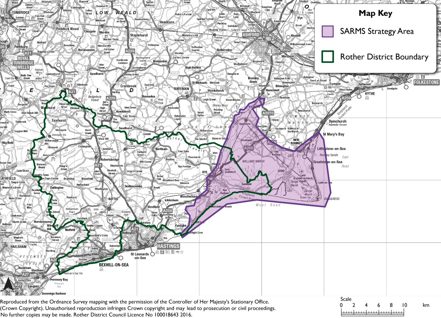
All development within the strategy area of the Dungeness Complex Sustainable Access and Recreation Management Strategy (SARMS) (as shown in Figure 45) should have regard to the measures identified in that Strategy.
Proposals that have the potential to result in any increase in levels of recreational access within the SARMS strategy area will need to demonstrate measures to avoid impacts on the Dungeness Complex of Habitats Sites, and any such access should be focused on those areas with existing permitted walking and cycling routes, in order to protect undisturbed habitats. Appropriate measures either on or off-site will be secured as part of a planning permission either by condition or legal agreement.
Development that is deemed in conflict with the Strategy will not be supported.
Figure 45: The Sustainable Access and Recreation Management Strategy Area
Explanatory Text:
11.69 The potential impact of tourism policies on the Dungeness Complex of Habitats Sites was an issue first highlighted through the Council's Core Strategy's Habitat Regulations Assessment (HRA). Therefore, the Council, in partnership with Folkstone & Hythe District Council with advice from Natural England, prepared a 'Sustainable Access and Recreation Management Strategy' (SARMS) for the area.
11.70 The district benefits from many areas of land that are protected for their environmental importance. However, as part of the successful management of these sites, there is sometimes a need to proactively protect areas from overuse.
11.71 The SARMS provides a strategic, cross boundary approach to managing recreational pressure and disturbance, both in relation to additional usage resulting from development and more generally to ensure sensitive management of the Habitats Sites. It identifies a need to raise the profile of the nature conservation value of the strategy area in a way that will also benefit the visitor economy, to improve visitor education and, in some areas, change behaviour to support the habitats and species of the protected sites.
11.72 The SARMS area, which covers the protected sites as well as a wider area of functional land providing an important supporting role, is shown in Figure 45.
Regulation 18 Commentary:
11.73 The importance of this strategy needs strengthening due to the significance of protecting the Dungeness Complex from inappropriate development. The proposed policy provides clearer messaging on its role.
Question Box
(3) 197. What are your views on the Council's proposed policy on the Sustainable Access and Recreation Management Strategy?
198. Are there any alternatives or additional points the Council should be considering?
(2) Proposed Policy ENV7: Environmental Pollution
Policy Status:
Non-strategic
New Policy?
No, updated version of DaSA Policy DEN7
Overall Priorities:
Green to the Core & Live Well Locally
Policy Wording:
Development will only be permitted where it is demonstrated that there will be no adverse impacts on health, local amenities, biodiversity or environmental character as a result of lighting, noise, airborne pollutants, water quality, land contamination, odour, hazardous and/or non-hazardous substances associated with development.
This includes where appropriate, the cumulative impacts of existing and proposed developments. Developments should put good design first to minimise the need for mitigation measures.
Regarding specific forms of pollution:
- In relation to noise, consideration will also be given to the character of the location and established land uses. Also, in the case of new noise-sensitive development, the 'agent of change' principle applies to the new development and appropriate design and mitigation must be provided in the new development. In any instance, good acoustic design will be required (as set out within Professional Practice Guidance on Planning & Noise - New Residential Development)
- In relation to new noise generating equipment, any such installation should have regard to the existing background noise levels of the area and not be louder than existing background noise levels. In some cases the Council may require equipment to be below background noise levels; and
- In relation to lighting, the proposed scheme is necessary and the minimum required, and is designed to minimise light pollution including light glare and sky glow and to conserve energy, through the use of best available technology, having regard to the lighting levels recommended by the Institution of Lighting Professionals (ILP) for the relevant environmental zone. Development should also be in accordance, where relevant, with Policy LAN3 (Dark Skies).
Permitted development rights for any noise generating equipment may be removed via condition where it is felt reasonable and necessary to ensure the protection of the environment from any form pollution.
A suitably qualified person must be used to carry out any assessments to demonstrate compliance with this policy.
Explanatory Text:
11.74 Environmental pollution can come in many forms. It will also affect parts of the district differently, particularly in the smaller rural villages and settlements as well as the countryside itself.
11.75 Environmental pollution issues will vary depending on the location and type of development involved. However, in all cases it will be appropriate to consider the effect of proposals, including any cumulative effects, in terms of their potential to contribute to or be adversely affected by pollution through issues such as lighting, noise, airborne pollutants, land contamination, odour, and/or hazardous and non-hazardous substances.
11.76 The general approach is to ensure that the impacts of new development are properly assessed at an early stage to keep their effects to a minimum. This will require new development to be designed from the outset in such a way as to minimise these impacts. It is therefore important to seek to protect residential amenity and the character of an area whilst also supporting growth.
11.77 Planning compliments the work of the Council's Environmental Health department in their duties. These include advising on planning applications where there is a crossover in remit, licencing for various uses and investigating statutory nuisance complaints. The proposed policy enables both departments to carry out their duties effectively.
11.78 There are many different forms of environmental pollution which will be expanded on in the more detail. In many of these instances, the 'agent of change' principle applies. Broadly speaking, this places the burden on the new development to ensure that the occupants will not be adversely affected by any existing, noisier businesses and development in close proximity.
Lighting
11.79 Artificial light can be an essential aid to safety, facilitate a thriving night-time economy and also extend the hours of use of sport and leisure facilities. Well-designed lighting can highlight architecturally or culturally significant buildings and features, creating visual interest and instil a sense of civic pride.
11.80 However, when poorly located, designed, maintained, or otherwise used incorrectly, artificial light can impact on people's health, wildlife's behaviour and safety. The result is an excessive use of energy, distracting road users and affecting the character and amenities of places, both in built-up areas and the countryside. Common sources of potential light pollution include sports venues, industrial, commercial and retail areas, street lighting and illuminated signage.
11.81 Particularly in rural areas, light pollution continues to affect landscape character and there is significant variation between, and even within, regions. Rother was found to be the 24th darkest English district out of 326 districts and boroughs in a 2016 study by the Campaign to Protect Rural England (CPRE). Dark skies are a valued characteristic of the district's countryside and contribute to the special landscape qualities and natural beauty of the High Weald NL. See Policy LAN3 (Dark Skies) in the landscape character chapter. Development will need to accord with both the environmental pollution policy and the dark skies policy where applicable.
11.82 Nationally, approximately half of all complaints regarding light nuisance arise from domestic external security lighting. Such lighting is not normally subject to planning control, while operational lighting for roads benefits from permitted development rights. Illuminated advertisements, which generally require permission. See Policy HER3 in relation to shopfronts, signage and advertising in the design and heritage chapter.
11.83 There is further information within both the NPPF and PPG regarding the consideration of light pollution in the context of new development. This can broadly be summarised as needing to consider the following points (although the PPG goes into greater detail, including links to professional guidance which the Council supports):
- the need for the lighting, its duration, intensity and direction;
- the impact of light levels outside the development;
- the effect on the use or enjoyment of nearby buildings or open spaces;
- the impact on nature conservation, including any protected sites or species; and
- whether the development is in an intrinsically dark landscape where it may be desirable to minimise new light sources.
11.84 Another important guidance document is the Institute for Lighting Professional's (ILP) Guidance Note 1 for The Reduction of Obtrusive Light (2021). It sets out five 'environmental zones' and identifies, for each zone, the suitability of various lighting designs and intensities. The measurement of light intensity is different to that used by CPRE, but nevertheless Rother District can be categorised in the following environmental zones:
- E1: the Pevensey Levels and the Dungeness Complex of international nature conservation sites, the High Weald NL outside of towns and villages as defined by settlement development boundaries;
- E2: within settlements and elsewhere outside areas in E1 and E3;
- E3: within Bexhill and the town centres of Battle and Rye.
11.85 Regarding lighting within sports provision, Sport England has produced a design guide for artificial sports lighting. The guide refers to the ILP's Guidance Note and will be referred to when considering artificial sports lighting.
11.86 For larger developments involving outdoor lighting, or those developments in or adjacent to sensitive locations, the Council may require a full lighting assessment and strategy to be submitted and prepared by a qualified lighting engineer.
(1) 11.87 Where planning permission is granted, appropriate conditions will normally be attached to control the lighting scheme, such as:
- specification of lighting type, height, angle etc.;
- hours of operation;
- retention of screening vegetation;
- use of new planting or bunding;
- details of a future scheme of maintenance; and/or
- post installation checks.
Noise
11.88 Many developments have the potential to affect the acoustic environment. They may involve the introduction of new noise sources, or new noise-sensitive developments near existing noise sources. It is necessary for the Council to carefully manage development to ensure that noise does not give rise to unacceptable adverse effects on health and quality of life, or on the character of areas. This is supported by both the NPPF and PPG.
11.89 The Planning Noise Advice Document (pdf) has been produced by the Sussex Pollution Working Group. This document provides detailed guidance for developers on the preparation of noise reports, mitigation measures as well as the conditions that may be applied to planning applications. Nationally, noise guidance for new residential development has been produced by the Association of Noise Consultants (ANC), Institute of Acoustics (IOA) and Chartered Institute of Environmental Health (CIEH).
11.90 The Council requires technical information to be provided with planning applications in the form of a 'Noise Impact Assessment' for:
- all applications for plant installation;
- any application for development/use that involves activities that may generate significant levels of noise adjacent to existing noise sensitive uses (e.g. residential development, schools and hospitals); or
- any application for noise sensitive development (e.g. schools, hospitals and residential development (excluding householder development)) adjacent to major road / transport infrastructure.
11.91 Additionally, the IOA and CIEH have produced a specific advice note on heat pumps. Many installations are carried out under permitted development rights. However, the advice states that for permitted development installations, adherence to the regulations alone may not avoid the creation of adverse impacts from noise and vibration. This is because there are several factors that can increase the potential for disturbance that are not fully covered in the permitted development regulations. The Council therefore strongly recommends that all heat pumps are installed using the guidance in the advice note to minimise the likelihood of any statutory nuisance complaints. The Council will apply this advice note to those that do require planning permission.
Air pollution
11.92 It is acknowledged that no part of the district is designated as an Air Quality Management Area. Therefore, there is not an exceedance or likely exceedance of an air quality objective, as defined within the Government's Air Quality Strategy.
11.93 However, this does not mean that the impact of new development on air pollution should not be considered. Air pollution is associated with a number of adverse health impacts.
11.94 The Council is part of Sussex Air Quality Partnership which is a Sussex wide partnership of local authorities including the County Council. They have produced guidance on more localised requirements for applicants and developers which the Council endorses and expects applicants to use. It may also be appropriate to incorporate measures that minimise air pollution as part of developments, such as traffic management schemes.
11.95 It is also noted that green spaces, particularly treed areas, can provide an important service in filtering pollutants. Guidance on the consideration of air quality through the planning system is available from Environmental Protection UK and the Institute of Air Quality Management (IAQM), such as the 2017 guidance on Land-Use Planning & Development Control: Planning For Air Quality.
Land contamination
11.96 The planning system plays a complimentary role with dealing with land contamination alongside a range of other systems and legislative requirements. This means that planning policies should be contributing to an enhanced environment and safe for the new use. Both the NPPF and PPG expand further on the considerations required when dealing with land contamination and remediation. Responsibility for securing a safe development rests with the developer and/or landowner. However, the Council should be satisfied that a proposed development will be appropriate for its location and not pose an unacceptable risk.
11.97 Previously developed land (or brownfield land) has the potential to be impacted by historical contamination and this should be fully investigated at an early stage of any development proposal. Developments involving ground works on or in the vicinity of sites where contamination is known or suspected will also require investigation. In Rother, this can commonly include, but not be limited to, proposals involving the conversion of former agricultural buildings. Any investigation and assessments must be carried out by a suitable qualified person. This will likely be a person accredited by the National Quality Mark Scheme (NQMS) for Land Contamination Management.
Odour
11.98 Odour may arise as an issue in various developments, such as restaurant and takeaway uses where cooking smells may affect the amenity of nearby residents, or where existing odour-generating uses could affect new development, such as from wastewater treatment works. These odours could result in the need for buffer zones between the source and receptor, such as residential development.
Hazardous substances
11.99 Sometimes pre-existing hazards need to be taken into account by development proposals. Key factors are the distance, risks and nature of the proposal. As per the PPG, in these cases, pre-application advice should be sought from the Health and Safety Executive (HSE) and the Environment Agency where relevant. The Council will use the advice of the HSE in its decision-making process, including where applications are near "notifiable installations" such as high-pressure gas mains and overhead power cables. Guidance is available from the Environment Agency for development involving decommissioning underground storage tanks, such as those found in petrol stations.
11.100 Any site that needs to use or store hazardous substances at or above specified controlled quantities, requires hazardous substances consent before it can operate. Further guidance is available on the PPG.
11.101 The proposed policy aims to reflect the wide-ranging forms of environmental pollution with an appropriate and proportionate approach to addressing them. This should mean the new development takes account of these factors to provide a positive outcome.
Question Box
(7) 199. What are your views on the Council's proposed policy on environmental pollution?
(7) 200. Are there any alternatives or additional points the Council should be considering?
(6) 201. Are there any other forms of pollution that the Council should be considering for a specific sub-point, and if so, what evidence is available?
[115] Residential development is defined as having a lifetime of at least 100 years. The starting assumption for non-residential development is 75 years.
[116] Pevensey and Cuckmere Water Level Management Board (PCWLMB) and Romney Marshes Internal Drainage Board (RMIDB).
[117] Through the implementation of Schedule 3 of the Flood and Water Management Act 2010.
[118] Residential development is defined as having a lifetime of at least 100 years. The starting assumption for non-residential development is 75 years.
[119] Accretion is defined as "the gradual increase in the area of land as a result of sedimentation".
[120] As defined by the NPPF, December 2023.
[121] As defined through Section 41 of the Natural Environment and Rural Communities Act (2006, as amended).
[122] The Dungeness Complex of Habitats Sites comprises three overlapping international designations - the Dungeness, Romney Marsh and Rye Bay Special Protection Area (SPA) and Ramsar site, and the Dungeness Special Area of Conservation (SAC).
[123] Protection is afforded through The Hedgerow Regulations 1997 (and any subsequent amendments)