Rother Local Plan 2020-2040 (Regulation 18)
5. Development Strategy and Principles
5.1 The NPPF requires all local plans to promote a sustainable pattern of development that seeks to:
- meet the development needs of their area;
- align growth and infrastructure;
- improve the environment;
- reduce the overall need to travel and maximise opportunities for sustainable travel;
- mitigate climate change (including by making effective use of land in urban areas); and
- adapt to its effects.
5.2 It also requires strategic policies to, as a minimum, provide for objectively assessed needs for residential and non-residential uses. This should include, if possible, meeting any development needs that cannot be met within neighbouring authority areas. These should be met unless the protection of areas or assets of particular importance provides a strong reason for restricting the overall scale, type or distribution of development in the district; or any adverse impacts of doing so would significantly and demonstrably outweigh the benefits.
5.3 The 2014 Core Strategy planned for a growth level of at least 5,700 dwellings between 2011 and 2028 which works out at 335 homes per year. The actual number of houses built each year since has averaged 219 (net additional dwellings per year). By contrast, Rother's minimum local housing need (LHN) figure, defined using the national standard method calculation is 733 dwellings per year (2023 Base date). It is the role of the Local Plan to identify the number that can appropriately be accommodated, and it is this "appropriate" growth that this development strategy plans for. The aim is to meet the needs of the district, including the need for affordable housing.
5.4 The planning period for this Local Plan is 2020-2040. It is important that the Council has a 15-year plan from its adoption date. The planning period overlaps with the Core Strategy period (2011-2028). This Local Plan therefore reconsiders and updates planned-for growth to 2028[20] as well as considering growth beyond this to 2040, to create a development strategy for the planning period.
(2) 5.5 While the challenges of creating sustainable settlements in Rother are high, change and growth is required to meet the community's needs including:
- providing appropriate housing and job opportunities;
- improving local access to services and facilities;
- ensuring a mix of house sizes across the district, including for those in affordable housing need; and
- utilising change and growth to enable people to live locally and reduce the need to travel, particularly by private car.
(3) 5.6 The Council has planned positively by undertaking a comprehensive assessment of development potential through its Housing and Employment Land Availability Assessment (HELAA) and the Settlement Study, to establish whether housing growth could be significantly increased. Over 200 sites have been put forward through a Call for Sites. To 'leave no stone unturned', the Council has identified and assessed nearly 800 additional sites, which include sites currently allocated or with planning permission.
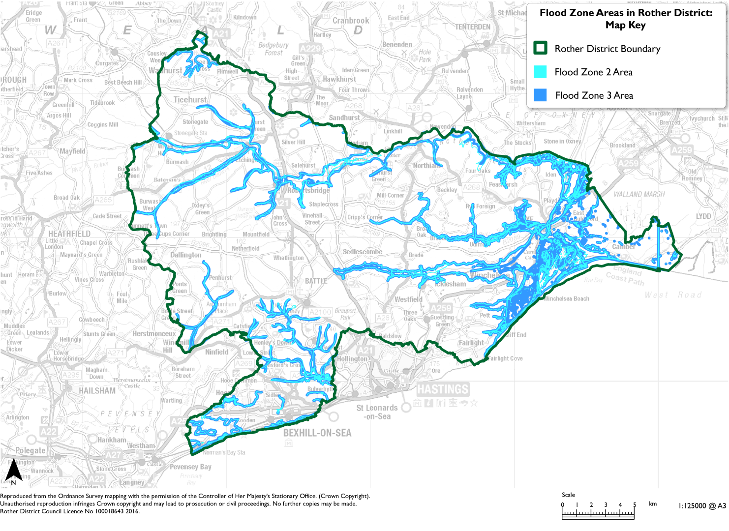
(1) 5.7 Development will only be acceptable where it does not have an adverse impact on the natural environment. There are many constraints across the district which impact on the overall suitability of land. Development will need to be steered away from areas of high flood risk, designated habitats sites and other areas with important high landscape value. With regards to flooding, in line with the NPPF, the development strategy will take a sequential development approach to ensure that suitable land is identified in lower risk areas before development in areas at higher risk of flooding from all sources is considered, with any appropriate mitigation. This will be informed by the Council's Strategic Flood Risk Assessment (SFRA) which is currently being developed. The Council will use this approach to inform decisions on the potential sites for development and any subsequent site allocations, at the next stage of the Local Plan. Figure 9 indicates the locations of areas within Flood Zones 2 and 3 across the district.
(1) Figure 9: Flood Risk Areas in Rother District
5.8 In line with the NPPF, all available spatial development options have been considered in principle, including options such as new settlements and proportional (by size and population) growth of existing settlements. The Development Strategy background paper explains the process that was undertaken and the justification for the proposed development strategy, which is further supported by a sustainability appraisal.
(5) Preferred Spatial Development Options:
The Council has considered a series of potential spatial development options (SDOs), and these have been individually assessed through the Sustainability Appraisal process. These 'alternatives' are detailed in the Development Strategy Background Paper. Through this process, the Council has considered all reasonable opportunities to accommodate growth, and these have varying degrees of impact on overall sustainability principles.
The Background Paper provides the analysis of why specific spatial development options are proposed to form part of the development strategy, and the reason others have been discounted. An important consideration has been the alignment of the development strategy with the Council's twin Overall Priorities - 'Green to the Core' and 'Live Well Locally' to ensure that growth is truly sustainable.
The background paper concludes that the most appropriate spatial development options to take forward as Rother's proposed development strategy is a combination of the following options:
- Brownfield intensification and redevelopment within sustainable settlements (Option reference SDO6).
- Bexhill greenfield growth on the northern and western edges of the built-up area of Bexhill to create new compact, connected communities (SDO3A)
- Hastings Fringes urban growth (SDO5)
- Radial settlement network connected to Bexhill and Hastings (SDO2)
- Village clusters centred around Rye and Battle (SDO1)
- Sustainable settlement growth (SDO4) with longer term, a focus on the A21 Corridor (SDO10).
Question Box
(35) 51. What are your views on the Council's preferred spatial development options?
(5) 52. Do you have any comments on the merits of the alternative Spatial Development Options, that do not form part of the preferred development options – as explained in the background paper?
(12) 53. Are there any other development options that the Council should consider as part of its Local Plan?
(8) Proposed Strategy: Overall Spatial Development Strategy
Strategy Wording:
The Council will meet the local need for all forms of housing, jobs, facilities and services by strengthening Rother's pattern of development through a landscape-led spatial development strategy that focuses on the 'Live Well Locally' concept. To achieve this, a minimum of [5,158 to 7,287]* dwellings, at an average rate of [258 to 364]* per year and a minimum of 74,189sqm* additional employment floorspace will be constructed by the end of the Plan period in 2040.
Bexhill will continue to be a town that acts as a main transport and community hub. A network of settlements surrounding both Bexhill and Hastings (outside the local authority) will be able to access the two towns' wider services and facilities by sustainable modes of transport.
Rye and Battle will be the centre of clusters of settlements that collectively provide what most residents need for their daily lives. Rye and Battle will continue to be key transport and community hubs, with improved active and public transport, better connecting the cluster of settlements to the towns. There are opportunities for sensitive growth in these clusters alongside new facilities and services for both new and existing residents to benefit from.
Based on these principles, the focus for growth will be in the following broad locations:
- West and North Bexhill to consolidate Bexhill as the most sustainable town, within the capacities of the existing transport network;
- clusters of villages based around the towns of Battle and Rye which act as key transport hubs;
- settlements on radial routes connected to the main urban areas of Bexhill and Hastings, allowing sensitive development in locations that rely on the larger towns for services and facilities;
- development at Hastings Fringes, providing sensitive growth;
- urban intensification and redevelopment across the district in appropriate and sustainable brownfield site locations;
- sensitive development in other rural settlements of the district; and
- in the longer-term, sensitive growth along the A21 Corridor.
*The final housing and employment target will be minimum figures. For the Regulation 18 consultation, the overall housing and employment figures are presented as a range, with the lower figure representing the totals of the "identified sites" (current allocations and sites with planning permission), and the upper figure representing the identified sites plus the total capacity of "potential additional sites" (sites identified in the draft HELAA as being potentially suitable, available and achievable for development during the Local Plan period). Therefore, the range is subject to change (either by an increase or reduction). The stated employment target in this box is the employment need figure in the HEDNA, 2024. The employment figures presented as a range for each sub-area represent the employment supply – which is higher than the need figure.
(1) Figure 10: Rother Development Strategy – Key Diagram – a pictorial representation of the development strategy
Explanatory Text:
(1) 5.9 The proposed spatial development strategy seeks to maximise development opportunities while also delivering the Local Plan's vision and objectives. Growth will be directed to settlements and locations in line with the proposed strategy above, and this will be informed by the overall sustainability of the settlement (as assessed in the Settlement Study), physical and environmental constraints, and the number of sites within or around settlements that have been assessed as 'identified' or 'potential additional' sites in the Council's draft HELAA.
(1) 5.10 Sites that have been categorised at this stage as 'potentially developable' are those where the Council requires confirmation that from the landowner that a site is available, or where there are outstanding issues relating to site suitability and achievability. As such, a development range is presented to reflect the potential variance in the quantum of development that has been assessed as being able to be accommodated.
(2) 5.11 The rural setting of the district comprises differing landscapes from the network of villages and hamlets within the High Weald NL; to the coastal areas connected to the main towns. The Council is committed to supporting the growth of rural communities in a way that promotes improvements to sustainable transport options allowing residents access to neighbouring communities to share facilities and services. While the district currently has many isolated dwellings, farmsteads and commercial activities within the countryside outside of defined settlement areas, the Council will prioritise growth within or on the edge of existing well defined built-up areas with good access to services, in order to facilitate sustainable development. In line with national policy, where opportunities for appropriate and policy compliant brownfield redevelopment arise these will be considered favourably. This will allow for windfall development to come forward on a site-by-site basis.
(2) 5.12 It is difficult for settlements in rural areas to function as highly sustainable locations, with organisations such as the Campaign for Rural England (CPRE) and Rural Services Network publishing reports seeking to highlight key issues and solutions. RTPI Cymru recently published a Discussion Paper exploring the role the planning system can play in supporting more sustainable, local living in Wales and the Scottish Government has stated that its new spatial strategy will apply the concept of 20-minute neighbourhoods throughout Scotland with a new emphasis on how living locally could work across Scotland, including remote rural communities.
(2) 5.13 The isolated and small-scale nature of some rural communities means that they often lack access to jobs, retail, health and care services and schools and community facilities leading to many residents having to travel to access them, mainly by private car. In addition, housing can be unaffordable and digital coverage is sometimes a challenge. This being said, home delivery for retail needs and other services is generally increasing throughout the district, including in rural areas. More positively, rural areas can offer a sense of community, sustainable food production, access to nature, nature recovery areas and local tourism. While cycling and walking can be difficult to encourage if there are few pavements and no street-lighting, initiatives like Quiet Lanes and Slow Ways could address these issues positively.
(1) 5.14 Key issues for rural communities which have been highlighted through early engagement on the Local Plan include:
- The ability for economic growth in rural locations to support agricultural uses alongside smaller rural based businesses.
- Providing sustainable transport options and greater accessibility to serve the facilities and services within rural towns and villages and consider the need for sufficient parking provision.
- The challenge of enabling all generations to stay in rural communities for their lifetime, and particularly enabling older people to downsize and younger generations to not be priced out of the area.
(1) 5.15 The spatial strategy views our rural communities as 'clusters' of settlements that cooperate like an eco-system, rather than separate places.
(1) 5.16 By making our rural communities more attractive, we can help retain young people locally, provide more opportunities for existing communities, build community cohesion and interaction, and reduce social isolation. Creating community pride and connection to places benefits health and wellbeing and can help rebalance local economies.
(1) 5.17 The employment need figure of 74,189sqm applies to the whole district. The Rother and Hastings joint Housing and Economic Development Needs Assessment (HEDNA) (2024) does not identify a separate figure for the rural areas. While the delivery of floorspace in rural areas over the past decade indicates that they will have a continued role in meeting overall future needs, including providing some flexibility to meet changing market demand particularly in the small-scale office market, there is no clear evidence that a specific employment floorspace requirement needs to be identified.
5.18 Despite a relatively high increase of floorspace in rural areas during this time, the continuation of these trends, without a substantial delivery of the existing pipeline in urban areas, would meet only a very small proportion of the overall need figure. Moreover, patterns of demand and supply should be considered primarily as part of the FEMA total. Instead of establishing a need figure for the rural areas, the approach of the Local Plan is to support diversification and allow rural businesses to respond to external factors, including changing markets and climate change.
5.19 The need figure (from the HEDNA, 2024) in this overall spatial development strategy is lower than the existing pipeline of employment floorspace throughout the district, that consists of existing Local Plan allocations, sites with planning permission, as well as sites with expired permission that have been identified as developable in principle. The employment need figures and the current supply of employment floorspace are set out in Figure 11 below.
(1) Figure 11: Demand vs supply balance, employment floorspace (sqm)
|
Employment Typology |
Need (HEDNA, 2024) |
Current Supply |
Balance |
|
Office |
22,776 |
47,970 |
25,194 |
|
Light Industrial & Industrial |
18,991 |
47,970 |
28,979 |
|
Storage & Distribution |
32,422 |
10,660 |
-21,762 |
|
Total |
74,189 |
106,600 |
32,411 |
5.20 With the exception of storage and distribution, Rother's current pipeline of employment floorspace exceeds its future requirement in this plan period. Consequently, the delivery of existing allocations and other commitments remains a priority. The deficit in the balance of storage and distribution floorspace is a concern, though it is considered that the surplus of commitments of industrial floorspace provides a justification for a flexible approach for taking forward existing site allocations.
5.21 At the same time, the delivery of existing commitments is by no means certain, and therefore the surplus identified above is not considered to constitute an oversupply of floorspace. The HEDNA (2024) identifies that continued public sector interventions will be required to ensure that existing allocations are delivered, including those in Bexhill which form a large proportion of the committed supply pipeline. Moreover, the HEDNA emphasises the uncertainty in forecasting future need, given the macroeconomic and technological factors identified above. This requires an economic strategy that is flexible enough to respond to a changing economic climate.
5.22 The Local Plan will meet this target, both through direct intervention in the form of flexible site allocations, as well as a policy approach that supports sustainable economic development that comes through the market. Local Plan policies must also reflect the substantially different geographies within the district; economic issues and challenges in rural areas are often different from those in urban areas, necessitating a unique set of policies relating to rural development.
5.23 It should be noted that employment floorspace does not include all sectors that employ people. For instance, other significant employers in Rother, include the education, healthcare, community, visitor accommodation, retail, leisure and agriculture sectors which for planning purposes do not comprise 'employment uses'. Policies in relation to all these sectors are set out in this plan.
Regulation 18 Commentary:
(2) 5.24 The Council is specifically interested in the views of stakeholders and the local community on the concepts and principles of development that are identified within the development strategy.
(1) 5.25 It is important to note that the housing and employment figures are indicative and provide 'potential' numbers based on the sites identified in the draft Housing and Economic Land Availability Assessment (HELAA). It is recognised that many of the potential sites, listed in the draft HELAA, require more detailed consideration of their impacts, including cumulative impacts. It is also possible that additional sites will be identified through this consultation.
5.26 In seeking to maximise its potential supply the Council wish to be transparent about this process and receive feedback through this consultation on the opportunities for development that are proposed including the potentially developable sites identified in the HELAA, and to develop its evidence base to support the most suitable and sustainable sites coming forward for development.
5.27 The position on the developability of sites will change in response to feedback and as the Council progresses the plan. The HELAA will be updated to reflect this as the plan progresses. Further testing will also be undertaken after the Regulation 18 consultation stage, such as transport modelling.
Question Box
(67) 54. What are your views on the Council's proposed spatial development strategy and proposed minimum targets for housing and employment growth?
(10) 55. Are there any alternatives or additional points the Council should be considering?
Delivering the Spatial Development Strategy
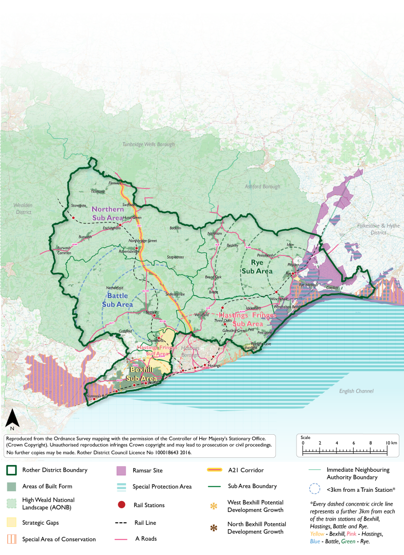
5.28 Rother's proposed development strategy has been split into five spatial sub-areas, Figure 12, which align with the principles and focus areas of growth presented above. Each of these spatial sub-areas has their own vision statement and identified distribution of development, which follows in the remainder of this chapter. The five sub-areas comprise:
- Bexhill;
- Hastings Fringes and settlements that radially link to Hastings;
- Battle and its cluster of connected settlements;
- Rye and its cluster of connected settlements; and
- Northern Rother – the settlements in the north-east of the district.
5.29 While the development strategy has been split into five areas, it is recognised that residents will utilise services and facilities in multiple major towns, villages and rural areas within and outside the district, to enable them to live well locally. While there is overlap, for clarity, settlements (and their identified growth potential) have been presented in only one of the five sub-areas.
5.30 In all five sub-areas there is open countryside, which has its own vision in this chapter. It relates to those areas outside of villages with development boundaries and includes farmland, woodland, hamlets and scattered development.
Figure 12: Rother District split into the Five Sub-Areas of the Development Strategy
(4) Vision for Bexhill
Bexhill will be the key focus for sustainable residential and commercial growth, within the urban area on brownfield sites and at its edges through 'live well locally' urban extensions on greenfield sites. There is potential to deliver a minimum of [2,163-3,398] dwellings and [39,572-59,256] sqm of employment floorspace across the Bexhill sub-area.
Supporting infrastructure will be delivered to serve the growing local and wider communities that live, work, and visit the area. Development opportunities will be realised across the town, and development densities will be maximised especially within the main town centre.
The 'broad locations' of west and north Bexhill will continue to grow as 'live well locally' urban extensions sensitively and at higher densities where sustainable to do so. Development will be well connected to the main urban areas, local neighbourhoods through sustainable transport options, including pedestrian and cycle routes (a Bexhill Cycle Network connected to the National cycle network) as well as by car. Growth will only occur in areas that are well connected to the existing transport network, and this will help deliver improvements to the junctions and design of the existing A259 and other key routes.
Connections and accessibility to settlements that are in close proximity to Bexhill will be enhanced through improved public transport, active travel and road networks. This will ensure that wider services and facilities can continue to be accessed, enabling residents to live well locally.
A strong green strategic gap will be retained between Bexhill and Hastings, with the Combe Valley Countryside Park forming an important area for recreation and biodiversity. This will avoid coalescence, ensuring that both larger settlements maintain their identities and landscape character at their edges.
Where development is within the hydrological catchment area of the Pevensey Levels, higher standards of sustainable drainage systems will be delivered to avoid negative impacts on the water management of the sensitive environmental area.
5.31 Figure 13 and Figure 14 below illustrate a potential development strategy for Bexhill, in terms of the numbers of dwellings and the amount of employment floorspace that could potentially be delivered over the plan period.
5.32 The figures are divided into 'identified' growth and 'potential additional' growth. Identified growth includes those sites which are allocated for development, or which have an extant planning permission or a current planning application which has a resolution to grant, subject to a legal agreement. Potential additional growth includes those sites which may be suitable, available and achievable for development over the plan period (as listed in the draft HELAA), subject to further assessment work and the result of the Regulation 18 consultation. The potential additional growth does not include those sites listed in the draft HELAA where the availability is currently unknown. Therefore, the potential figures may be subject to change as the Local Plan consultation progresses, as sites are discounted, or alternatively, as additional sites are found to be suitable, available and achievable. This work will be undertaken through the ongoing HELAA. It should be noted that the Employment figures listed in the tables below may differ from those within the draft HELAA, as the HELAA also considers other economic uses including retail floorspace.
(1) Figure 13: Bexhill Development Strategy: Housing: Summary
|
Settlement |
- |
Sustainability Code |
Identified Level of Housing Growth |
Potential Additional Level of Housing Growth |
Total Potential Housing Growth (Identified + Additional) |
|---|---|---|---|---|---|
|
Bexhill |
North |
Highly Sustainable |
1,557 |
540 |
2,097 |
|
Bexhill |
West |
Highly Sustainable |
308 |
640 |
948 |
|
Bexhill |
Urban |
Highly Sustainable |
298 |
55 |
353 |
|
Total Growth |
2,163 |
1,235 |
3,398 |
||
Figure 14: Bexhill Development Strategy: Employment: Summary
|
Settlement |
- |
Sustainability Code |
Identified Level of Employment Growth (sqm floorspace) |
Potential Additional Level of Employment Growth |
Total Potential Employment Growth (Identified + Additional) (sqm floorspace) |
|---|---|---|---|---|---|
|
Bexhill |
North |
Highly Sustainable |
37,547 |
14,200 |
51,747 |
|
Bexhill |
West |
Highly Sustainable |
2,025 |
4,000 |
6,025 |
|
Bexhill |
Urban |
Highly Sustainable |
0 |
1,484 |
1,484 |
|
Total Growth |
39,572 |
19,684 |
59,256 |
||
5.33 Figure 16 below individually lists the 'identified' development sites in Bexhill. Equivalent tables are provided for each of the spatial sub-areas within this chapter. For detail on the 'potential additional' sites, please refer to the draft HELAA.
5.34 Identified development sites are either:
- allocated for development within the Rother Local Plan or a made Neighbourhood Plan;
- subject to an extant planning permission; or
- subject to a current planning application which is has been resolved to grant permission subject to completion of a legal agreement.
5.35 Where a site is subject to both an allocation and a planning permission (or resolution to grant), and the site capacity differs between the allocation and permission, the capacity indicated in the more recent of the two is shown in the table.
Figure 16: Bexhill Development Strategy: Development Sites - Identified
|
Planning Permission/ Site Allocation reference |
Site Allocation |
Site Name, Settlement |
Parish |
Residential Units |
Employment Floorspace (sq m) |
|
RR/2022/2364/P, DaSA allocation Policy BEX3a Note: Sites highlighted orange are sites currently allocated in the DaSA |
Site currently allocated in the DaSA |
Kiteye Farm and adjoining land |
Bexhill North |
250 |
0 |
|
RR/2022/1584/P, DaSA allocation Policy BEX3b Note: Sites highlighted orange are sites currently allocated in the DaSA |
Site currently allocated in the DaSA |
Land west of Watermill Lane |
Bexhill North |
130 |
0 |
|
DaSA allocation Policy BEX3c Note: Sites highlighted orange are sites currently allocated in the DaSA |
Site currently allocated in the DaSA |
Land east of Watermill Lane |
Bexhill North |
150 |
0 |
|
DaSA allocation Policy BEX6 Note: Sites highlighted orange are sites currently allocated in the DaSA |
Site currently allocated in the DaSA |
Land adjacent to 276 Turkey Road, Bexhill |
Bexhill North |
30 |
0 |
|
RR/2023/1527/P, DaSA allocation Policy BEX7 Note: Sites highlighted orange are sites currently allocated in the DaSA |
Site currently allocated in the DaSA |
Land at Moleynes Mead, Fryatts Way, Bexhill |
Bexhill North |
26 |
0 |
|
RR/2018/2790/P, DaSA allocation Policy BEX1 Note: Sites highlighted orange are sites currently allocated in the DaSA |
Site currently allocated in the DaSA |
Land at Levetts Wood and Oaktree Farm, Sidley, Bexhill |
Bexhill North |
0 |
33,500 |
|
RR/2017/963/P |
Unallocated site with planning permission, or which is subject to a current planning application with a resolution to grant subject to the completion of a legal agreement. |
Bexhill Enterprise Park – Escarpment Site B – south of Glovers End, Bexhill |
Bexhill North |
0 |
3,275 |
|
RR/2022/1233/P |
Unallocated site with planning permission, or which is subject to a current planning application with a resolution to grant subject to the completion of a legal agreement. |
Cemetery Lodge, 250 Turkey Road, Bexhill |
Bexhill North |
6 |
0 |
|
RR/2021/2545/P |
Unallocated site with planning permission, or which is subject to a current planning application with a resolution to grant subject to the completion of a legal agreement. |
Land west of Watermill Lane, Bexhill |
Bexhill North |
80 |
0 |
|
RR/2015/1760/P |
Unallocated site with planning permission, or which is subject to a current planning application with a resolution to grant subject to the completion of a legal agreement. |
Worsham Farm Site B, Land West of Mount View Street |
Bexhill North |
47 |
540 |
|
RR/2015/1760/P |
Unallocated site with planning permission, or which is subject to a current planning application with a resolution to grant subject to the completion of a legal agreement. |
Worsham Farm Site D, Land East of Mount View Street |
Bexhill North |
447 |
232 |
|
RR/2015/1760/P |
Unallocated site with planning permission, or which is subject to a current planning application with a resolution to grant subject to the completion of a legal agreement. |
Worsham Farm Site E, Land South of Worsham Lane |
Bexhill North |
370 |
0 |
|
RR/2022/2719/P |
Unallocated site with planning permission, or which is subject to a current planning application with a resolution to grant subject to the completion of a legal agreement. |
Ardath House, Hastings Road, Bexhill, TN40 2HJ |
Bexhill North |
21 |
0 |
|
Totals: |
1,557 |
37,547 |
|||
|
RR/2017/1705/P, DaSA allocation Policy BEX9 |
Unallocated site with planning permission, or which is subject to a current planning application with a resolution to grant subject to the completion of a legal agreement. |
Land off Spindlewood Drive, Bexhill |
Bexhill West |
160 |
0 |
|
RR/2020/1410/P |
Unallocated site with planning permission, or which is subject to a current planning application with a resolution to grant subject to the completion of a legal agreement. |
Land south of Barnhorn Road & West of Ashridge Court, Barnhorn Road, Bexhill on Sea |
Bexhill West |
29 |
0 |
|
RR/2020/2260/P |
Unallocated site with planning permission, or which is subject to a current planning application with a resolution to grant subject to the completion of a legal agreement. |
Land at Clavering Walk, Bexhill on Sea |
Bexhill West |
70 |
0 |
|
RR/2022/3018/P |
Unallocated site with planning permission, or which is subject to a current planning application with a resolution to grant subject to the completion of a legal agreement. |
Land at Barnhorn Green, Bexhill on Sea |
Bexhill West |
0 |
2,025 |
|
RR/2023/926/P |
Unallocated site with planning permission, or which is subject to a current planning application with a resolution to grant subject to the completion of a legal agreement. |
Barn at Beeches Farm, Sandhurst Lane, Bexhill |
Bexhill West |
5 |
0 |
|
RR/2021/1621/P |
Unallocated site with planning permission, or which is subject to a current planning application with a resolution to grant subject to the completion of a legal agreement. |
49 Cooden Sea Road, Cooden |
Bexhill West |
9 |
0 |
|
RR/2022/2570/P |
Unallocated site with planning permission, or which is subject to a current planning application with a resolution to grant subject to the completion of a legal agreement. |
41A, 41 & 43 Barnhorn Road, Bexhill |
Bexhill West |
35 |
0 |
|
Totals: |
308 |
2,025 |
|||
|
DaSA allocation Policy BEX8 |
Unallocated site with planning permission, or which is subject to a current planning application with a resolution to grant subject to the completion of a legal agreement. |
Land south of Terminus Road |
Bexhill Urban |
10 |
0 |
|
RR/2020/155/P |
Unallocated site with planning permission, or which is subject to a current planning application with a resolution to grant subject to the completion of a legal agreement. |
2a Sackville Road |
Bexhill Urban |
6 |
0 |
|
RR/2019/430/P, DaSA allocation Policy BEX4 |
Unallocated site with planning permission, or which is subject to a current planning application with a resolution to grant subject to the completion of a legal agreement. |
Land at Former High School Site, Down Road, Bexhill |
Bexhill Urban |
52 |
0 |
|
RR/2020/577/P |
Unallocated site with planning permission, or which is subject to a current planning application with a resolution to grant subject to the completion of a legal agreement. |
30 Dorset Road, Bexhill |
Bexhill Urban |
8 |
0 |
|
RR/2021/1656/P |
Unallocated site with planning permission, or which is subject to a current planning application with a resolution to grant subject to the completion of a legal agreement. |
Land west of Fryatts Way, Bexhill |
Bexhill Urban |
210 |
0 |
|
RR/2021/1519/P |
Unallocated site with planning permission, or which is subject to a current planning application with a resolution to grant subject to the completion of a legal agreement. |
81 Cooden Drive, Bexhill |
Bexhill Urban |
5 |
0 |
|
RR/2023/1949/PN3 & RR/2023/2466/P |
Unallocated site with planning permission, or which is subject to a current planning application with a resolution to grant subject to the completion of a legal agreement. |
1 Burnside Mews, London Road, Bexhill |
Bexhill Urban |
5 |
0 |
|
Totals: |
298 |
0 |
Explanatory Text:
5.36 The vision for Bexhill reflects how the town is intended to grow and develop over the next 20 years up to 2040. Bexhill is the most sustainable settlement for growth. The construction of the Bexhill-Hastings Link Road (Combe Valley Way) and associated roads connecting with the north and north-east of Bexhill have opened up development opportunities including a sustainable new urban extension with housing, business parks, a primary school and green space at North-East Bexhill (under construction) and housing and employment growth to support Sidley (North Bexhill) (allocated for development in the Development and Site Allocations Local Plan which was adopted in 2019). Other larger sites in the western part of Bexhill have planning permissions. The Council's HELAA has assessed the development potential of a number of sites within the urban area (Bexhill central broad location) and adjoining or beyond the edge of the existing development boundary with a particular emphasis on opportunities for growth in north-east and west Bexhill.
5.37 The Council is exploring the opportunity for further development at west Bexhill as that area provides land opportunities that are outside the High Weald NL. It is considered that the east of Bexhill has reached its development limit without expanding into areas of high flood risk, the Combe Valley Countryside Park, or Sites of Special Scientific Interest (SSSI).
(1) 5.38 In west Bexhill there are other constraints in relation to the proximity to the environmental sensitivity area of the Pevensey Levels. This places higher importance on sustainable drainage measures within the identified hydrological catchment area. There are known capacity constraints on the A259 western route into Bexhill via Little Common and at the Little Common roundabout in particular where delays and congestion are currently experienced. In order to open up opportunities for development in West Bexhill, junction improvements and significant interventions, such as roundabout redesign, will be required to both alleviate road capacity and prioritise shared and active transport options on the existing network.
5.39 The Council has commissioned a discrete piece of work as part of a wider County Transport Assessment to assess the feasibility of a new transport corridor connecting the A259, west of Little Common roundabout, with Ninfield Road being delivered through the new Local Plan. The conclusion of the assessment is that there is no reasonable prospect of the delivery of a new road or 'multi-modal corridor' in the West Bexhill area, because the extent of new development is not sufficient to justify the cost. As such only sites that can access the existing road transport network are appropriate for consideration within the timeframe of this Local Plan. Any development in this area should focus on providing sustainable, active travel options, helping shift travel patterns and contributing to better connectivity between west Bexhill and the Town Centre, providing sustainable transport routes.
5.40 Development on greenfield land will be necessary to meet local needs due to the lack of available brownfield sites. It will be essential to ensure that any greenfield growth forming urban extensions are not isolated standalone developments or settlement areas, and that they form part of well-connected and sustainable communities that contribute to radically reducing carbon emissions.
5.41 The gap between Bexhill and Hastings/St Leonards is a valuable green lung between the towns. In this location approximately 600 hectares is designated as the Combe Valley Countryside Park to respond to a green infrastructure deficit in the area and provide a key area for leisure, recreation and biodiversity. While the landfill site which is central to the park has ceased to operate, there is continued use for waste collection and these sites are excluded from the Countryside Park in line with ESCC's Waste and Minerals Local Plan.
5.42 Any development will need to offer enhancements and biodiversity net gain, while being sensitive to historic landscape character. There are clear opportunities to improve the nature, landscape and recreation value of adjoining greenfield land to development sites (which is not suitable for building on) to help mitigate the loss of some open land.
5.43 There are neighbouring smaller settlements surrounding Bexhill that rely on services and facilities within Bexhill and/or Hastings and Battle to help meet local needs. While the majority of residents in nearby Crowhurst, Lunsford Cross, Normans Bay and Catsfield may travel by car to access services and facilities there is potential to strengthen overall public transport opportunities and build on these connections, including outside the local authority boundary such as Ninfield in Wealden. The settlements of Crowhurst and Catsfield have not been included as part of the Bexhill spatial sub-area, but are included in the Hastings and Battle sub-areas, so that identified growth is only accounted for once.
5.44 Growth in Bexhill provides a clear opportunity to:
- enable strategic planning matters such as the delivery of strategic infrastructure to be resolved through continuous cross-boundary joint working between RDC and HBC;
- increase the supply of housing and jobs;
- contribute to the enhancement of the Combe Valley Countryside Park by improving access to the countryside, support biodiversity net gain and the maintenance of the water network;
- improve the provision of sustainable bus services, cycling, wheeling and walking opportunities and connections across Bexhill as a whole, and to its neighbouring villages and settlements; and
- improve services and facilities within Bexhill, delivering important infrastructure alongside new development to ensure growth is sustainable and has wider benefits to the whole of the town.
Regulation 18 commentary:
5.45 It is important to note that at this moment in time, the housing and employment figures are indicative and provide 'potential' numbers based on the sites identified in the draft HELAA.
5.46 It is recognised that many of the potential additional sites require more detailed consideration of their impacts, including cumulative impacts. In Bexhill, a master-planning and design coding approach will be required to ensure that connected communities that meet our Live Well Locally concept are created, particularly in the broad areas for development identified in west and north Bexhill. This work, together with specific allocation policies will be developed after the Regulation 18 consultation stage. In seeking to maximise its potential supply, the Council wish to receive feedback through this Regulation 18 consultation on the opportunities for development that are proposed, and to develop its evidence base to support the most suitable and sustainable sites coming forward for development.
Question Box
(11) 56. What are your views on the vision for Bexhill?
(13) 57. What are your views on the two broad locations for growth (west Bexhill and north Bexhill) and their growth potential in the Bexhill strategy area in figures 13, 14 & 15?
(45) 58. What are your views on the potential sites identified in the draft HELAA that could accommodate more growth in Bexhill?
(1) Vision for Hastings Fringes and Radial Settlements
A small level of sensitive development will be delivered in the Hastings Fringes where it is well connected to the urban fabric of Hastings, to public and active transport routes, and to key services and facilities. Development will be sensitively designed and will sit appropriately in the landscape setting of the High Weald NL which wraps around the urban edge of Hastings.
Connections and accessibility to settlements that are linked radially to Hastings will be enhanced through improved public transport, active travel, and highway improvements. This will ensure that wider services and facilities can continue to be accessed, enabling residents to live well locally and have healthy lifestyles. Sensitive small-scale development will be delivered in villages surrounding Hastings, at densities consistent with the surrounding area, where it is sustainable to do so and does not negatively impact the setting of the High Weald NL.
Where greater opportunities for development arise in larger more sustainable villages, residential development will enable enhancement to public realm and community facilities. Growth will also help support existing facilities and services in the village, ensuring health and wellbeing and community cohesion is maintained and improved.
5.47 Figure 17 and Figure 18 below illustrate a potential development strategy for Hastings Fringes and Surrounding Settlements in terms of the numbers of dwellings and the amount of employment floorspace that could potentially be delivered over the Plan period. Please see paragraph 5.32 above for an explanation of the meaning of identified and potential additional growth.
(2) Figure 17: Hastings Fringes and Radial Settlements Development Strategy: Housing: Summary
|
Settlement Areas |
Sustainability Code |
Identified Level of Housing Growth |
Potential Additional Level of Housing Growth |
Total Potential Housing Growth (Identified + Additional) |
|---|---|---|---|---|
|
Rock Lane and Austen Way (Guestling parish) |
Good sustainability |
0 |
20 |
20 |
|
Westfield |
Good sustainability |
50 |
50 |
100 |
|
Woodlands Way and Parkwood Road (Westfield parish) |
Fair sustainability |
40 |
0 |
40 |
|
Crowhurst |
Fair sustainability |
30 |
12 |
42 |
|
Icklesham |
Fair sustainability |
0 |
15 |
15 |
|
Fairlight Cove |
Fair sustainability |
0 |
35 |
35 |
|
Guestling Green |
Poor Sustainability |
0 |
14 |
14 |
|
Total Growth |
120 |
146 |
266 | |
Figure 18: Hastings Fringes and Radial Settlements Development Strategy: Employment floorspace: Summary
| Settlement Areas |
Sustainability Code |
Identified Level of Employment Growth (sqm floorspace) |
Potential Additional Level of Employment Growth (sqm floorspace) |
Total Potential Employment Growth (Identified + Additional) (sqm floorspace) |
|---|---|---|---|---|
|
Rock Lane and Austen Way (Guestling parish) |
Good sustainability |
6,600 |
0 |
6,600 |
|
Westfield |
Good sustainability |
0 |
0 |
0 |
|
Woodlands Way and Parkwood Road (Westfield parish) |
Fair sustainability |
0 |
0 |
0 |
|
Crowhurst |
Fair sustainability |
0 |
0 |
0 |
|
Icklesham |
Fair sustainability |
0 |
0 |
0 |
|
Fairlight Cove |
Fair sustainability |
0 |
0 |
0 |
|
Guestling Green |
Poor Sustainability |
0 |
0 |
0 |
| Total Growth |
6,600 |
0 |
6,600 |
|
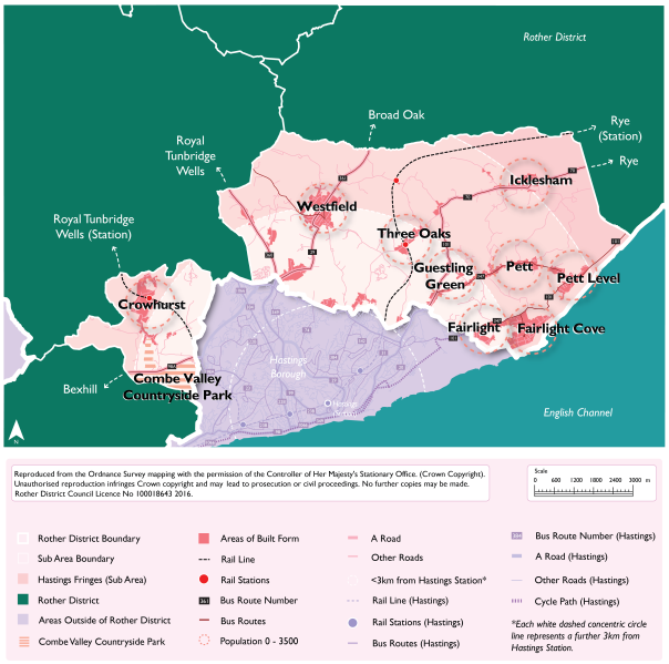
Figure 19: Hastings Fringes and radially connected settlements
5.48 Figure 20 below individually lists the 'identified' development sites for this sub-area. Please see paragraph 5.32 above for an explanation of identified sites. For detail on the 'potential additional' sites, please refer to the draft HELAA.
Figure 20: Hastings Fringes and Radial Settlements: Development Sites - Identified
|
Planning Permission/ Site Allocation reference |
Site Allocation |
Site Name, Settlement |
Parish |
Residential Units |
Employment Floorspace (sq m) |
|---|---|---|---|---|---|
|
Crowhurst Neighbourhood Plan allocation CH1 |
Site currently allocated in Neighbourhood Plans |
Land at Station Road/Forewood Lane, Crowhurst |
Crowhurst |
12 |
0 |
|
Crowhurst Neighbourhood Plan allocation CH3 |
Site currently allocated in Neighbourhood Plans |
Land adjacent to Station Car Park, Crowhurst |
Crowhurst |
6 |
0 |
|
Crowhurst Neighbourhood Plan allocation CH2 |
Site currently allocated in Neighbourhood Plans |
Land south of Forewood Rise, Crowhurst |
Crowhurst |
12 |
0 |
|
DaSA allocation Policy HAS3 |
Site currently allocated in the DaSA |
Land north of A265, Ivyhouse Lane, Hastings |
Guestling |
0 |
1,800 |
|
RR/2017/1829/P |
Unallocated site with planning permission |
Land at Burgess Road, Ivyhouse Lane Industrial Estate, Hastings |
Guestling |
0 |
4,800 |
|
DaSA allocation Policy HAS2 |
Site currently allocated in the DaSA |
Land at Michael Tyler Furniture, Woodlands Way, Hastings |
Westfield |
40 |
0 |
|
DaSA allocation Policy WES2 |
Site currently allocated in the DaSA |
Land at the former Moorhurst Care Home, Westfield |
Westfield |
40[21] |
0 |
|
DaSA allocation Policy WES3 |
Site currently allocated in the DaSA |
Land south-east of Goulds Drive, Westfield |
Westfield |
10 |
0 |
Explanatory Text:
5.49 The built-up area of Hastings extends, for the most part, up to the administrative boundary with its peripheral areas extending into Rother District. For the purposes of this Local Plan these areas are defined as 'Hastings Fringes', and these areas are contiguous with the built-up area boundary of Hastings. This encompasses areas along Westfield Lane, Beany's Lane, Woodlands Way, Parkwood Road, Sandhurst Gardens, Stonestile Lane, Chowns Hill, Ivyhouse Lane, Rock Lane and Batchelor's Bump.
(1) 5.50 A high proportion of the areas within the Hastings Fringes are within the High Weald NL, and some areas relate more to their rural surroundings than to the urban centre of Hastings. The topography and landscape setting of some of these areas mean that it is important that most land remains as countryside. There are, however, opportunities for well-designed and sensitive development which will be well connected to the urban edge of Hastings.
5.51 As well as areas defined within Hastings Fringes, there are also neighbouring settlements to Hastings that are well connected and depend on the larger town for access to key services and facilities. There are strong radial links with Hastings and the settlements of Westfield, Crowhurst, Three Oaks, Guesting Green, Pett, Icklesham and Fairlight within Rother, and as such a sensitive level of growth may be accommodated in some of these smaller settlements in locations that are considered sustainable.
Regulation 18 commentary:
5.52 It is important to note that the housing and employment figures are indicative and provide 'potential' numbers based on the sites identified in the draft HELAA.
5.53 It is recognised that many of the potential additional sites require more detailed consideration of their impacts, including cumulative impacts. This work, together with specific allocation policies will be developed after the Regulation 18 consultation stage. In seeking to maximise its potential supply, the Council wish to receive feedback through this Regulation 18 consultation on the opportunities for development that are proposed, and to develop its evidence base to support the most suitable and sustainable sites coming forward for development.
Question Box
(18) 59. What are your views on the vision for Hastings Fringes and surrounding settlements?
(14) 60. What are your views on the distribution and opportunities for growth in settlements within the sub-area in figures 17, 18 & 19?
(159) 61. What are your views on the potential sites identified in the draft HELAA that could accommodate more growth in Hastings Fringes and surrounding settlements?
(3) Vision for Battle and Surrounding Settlements
Battle will retain its historical character at its core and preserve its local distinctiveness and important setting within the High Weald NL. Employment opportunities will be enhanced through sensitive higher density commercial development within the town and in surrounding commercial areas. Opportunities for brownfield residential development within the urban areas of Battle will be realised with higher densities achieved in sustainable locations.
A greater amount of sensitive growth will take place south of North Trade Road and west of Hastings Road with linked opportunities for habitat creation, restoration, enhancement and community access.
Sensitive small-scale development will be delivered in villages surrounding Battle, at densities consistent with the surrounding area, where it is sustainable and does not negatively impact the setting of the High Weald NL. A small level of growth will help support improving the overall sustainability and vitality of the cluster of villages around Battle, through supporting existing services and facilities as well as delivering developer contributions for wider community benefit. This will ensure that health and wellbeing and community cohesion is maintained and improved.
(1) 5.54 Figure 21 and Figure 22 below illustrate a potential development strategy for Battle and surrounding settlements in terms of the numbers of dwellings and the amount of employment floorspace that could potentially be delivered over the Plan period. Please see paragraph 5.32 above for an explanation of the meaning of identified and potential additional growth.
Figure 21: Battle and Surrounding Settlements Development Strategy: Housing: Summary
|
Settlement Area |
Sustainability Code |
Identified Level of Housing Growth |
Potential Additional Level of Housing Growth |
Total Potential Housing Growth (Identified + Additional) |
|---|---|---|---|---|
|
Battle |
Good sustainability |
260 |
225 |
485 |
|
Sedlescombe |
Fair sustainability |
75 |
15 |
90 |
|
Catsfield |
Poor Sustainability |
35 |
25 |
60 |
|
Netherfield |
Poor Sustainability |
33 |
0 |
33 |
|
Brightling (Parish) |
0 |
0 |
0 |
|
|
Total Growth |
403 |
265 |
668 |
|
Figure 22: Battle and Surrounding Settlements Development Strategy: Employment: Summary
|
Settlement Area |
Sustainability Code |
Identified Level of Employment Growth (sqm floorspace) |
Potential Additional Level of Employment Growth (sqm floorspace) |
Total Potential Employment Growth (Identifed + Additional) (sqm floorspace) |
|---|---|---|---|---|
|
Battle |
Good sustainability |
1,895 |
2,700 |
4,595 |
|
Sedlescombe |
Fair sustainability |
6,515 |
0 |
6,515 |
|
Catsfield |
Poor Sustainability |
0 |
0 |
0 |
|
Netherfield |
Poor Sustainability |
0 |
0 |
0 |
|
Brightling (Parish) |
1,861 |
0 |
1,861 |
|
|
Total Growth |
10,271 |
2,700 |
12,971 |
|
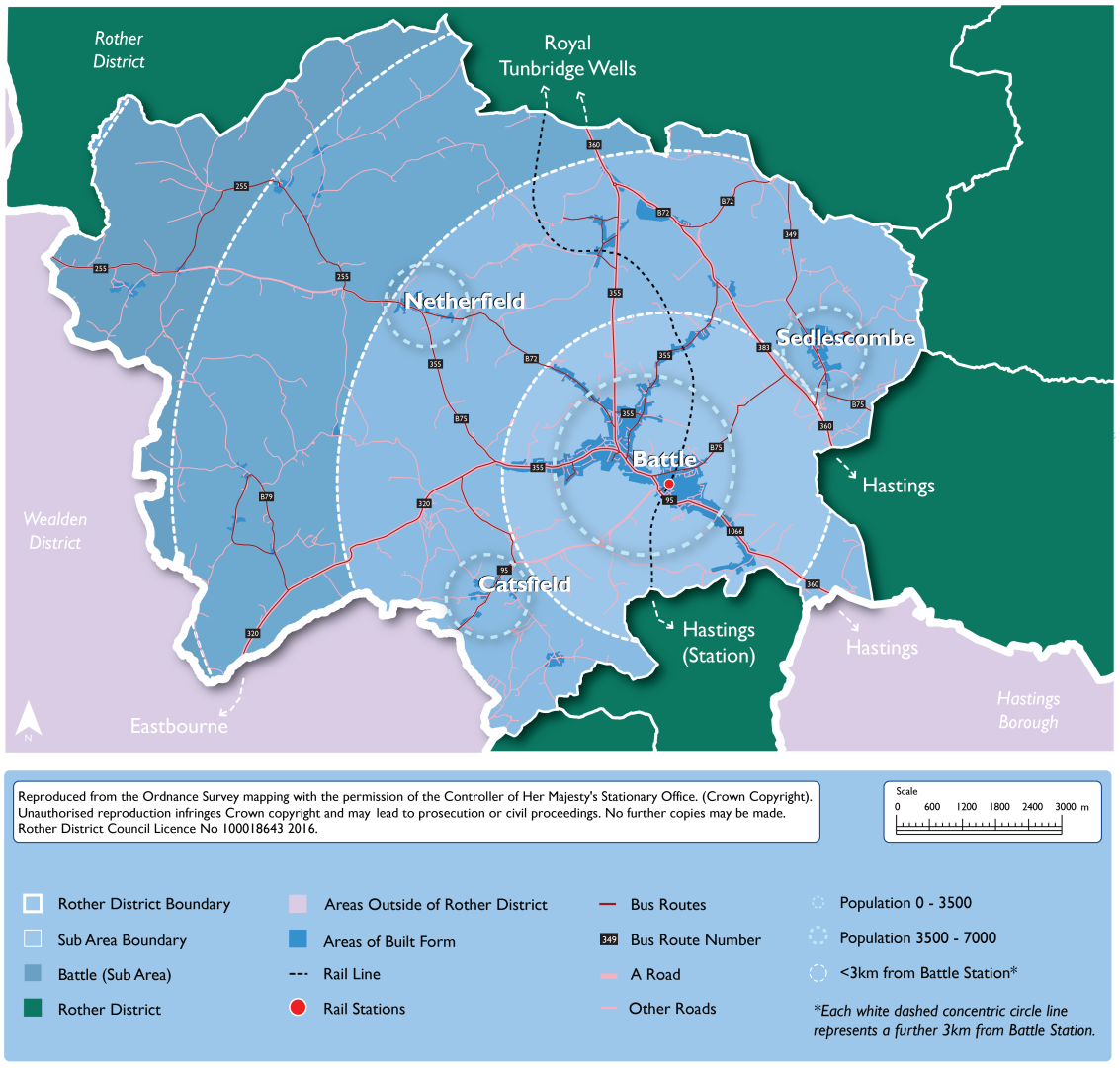
Figure 23: Battle and Surrounding Settlements Development Strategy
5.55 Figure 24 below individually lists the 'identified' development sites. Please see paragraph 5.32 above for an explanation of identified sites. For detail on the 'potential additional' sites, please refer to the draft HELAA.
(3) Figure 24: Battle and Surrounding Settlements: Development Sites - Identified
|
Planning Permission/ Site Allocation reference |
Site Allocation |
Site Name, Settlement |
Parish |
Residential Units |
Commercial Employment Floorspace (sq m) |
|---|---|---|---|---|---|
|
RR/2020/2307/P |
Unallocated site with planning permission, or which is subject to a current planning application with a resolution to grant subject to the completion of a legal agreement. |
Land at Blackfriars, Battle |
Battle |
220 |
0 |
|
RR/2021/1754/P |
Unallocated site with planning permission, or which is subject to a current planning application with a resolution to grant subject to the completion of a legal agreement. |
Land at Whitelands Cottage, North Trade Road, Battle |
Battle |
20 |
0 |
|
RR/2022/1765/P |
Unallocated site with planning permission, or which is subject to a current planning application with a resolution to grant subject to the completion of a legal agreement. |
Beech Farm, Battle |
Battle |
0 |
1,895 |
|
Battle Neighbourhood Plan allocation site NE05 |
Site currently allocated in Neighbourhood Plans |
Swallow Barn, Netherfield |
Battle |
10 |
0 |
|
Battle Neighbourhood Plan allocation site NE06a |
Site currently allocated in Neighbourhood Plans |
White House Poultry Farm, Netherfield |
Battle |
23 |
0 |
|
Battle Neighbourhood Plan allocation site BA36a |
Site currently allocated in Neighbourhood Plans |
Land at Calbec House, Calbec Hill, Battle |
Battle |
5 |
0 |
|
Battle Neighbourhood Plan allocation site BA31a |
Site currently allocated in Neighbourhood Plans |
Land to the east of Glengorse, Battle |
Battle |
15 |
0 |
|
DaSA allocation Policy CAT1 |
Site currently allocated in the DaSA |
Land west of B2204, Catsfield |
Catsfield |
35 |
0 |
|
Sedlescombe Neighbourhood Plan allocation Policy 2 |
Site currently allocated in Neighbourhood Plans |
Land at Sunningdale |
Sedlescombe |
8 |
0 |
|
Sedlescombe Neighbourhood Plan allocation Policy 4 |
Site currently allocated in Neighbourhood Plans |
Land at Church Hill Farm, North of Village Hall |
Sedlescombe |
12 |
0 |
|
Sedlescombe Neighbourhood Plan allocation Policy 5 |
Site currently allocated in Neighbourhood Plans |
Land at Sedlescombe Sawmills |
Sedlescombe |
8 |
1,115 |
|
Sedlescombe Neighbourhood Plan allocation Policy 6 |
Site currently allocated in Neighbourhood Plans |
Land adjacent to St John the Baptist Church |
Sedlescombe |
8 |
0 |
|
Sedlescombe Neighbourhood Plan allocation Policy 7 |
Site currently allocated in Neighbourhood Plans |
Land at Gate Cottage |
Sedlescombe |
8 |
0 |
|
Sedlescombe Neighbourhood Plan allocation Policy 8 |
Site currently allocated in Neighbourhood Plans |
Land at Church Hill Farm |
Sedlescombe |
10 |
0 |
|
RR/2022/2619/P |
Unallocated site with planning permission, or which is subject to a current planning application with a resolution to grant subject to the completion of a legal agreement. |
Street Farm, Sedlescombe |
Sedlescombe |
21 |
0 |
|
RR/2006/3467/P |
Unallocated site with planning permission, or which is subject to a current planning application with a resolution to grant subject to the completion of a legal agreement. |
Marley Lane Business Park, Marley Lane, Battle |
Sedlescombe |
0 |
2,400 |
|
DaSA allocation Policy MAR1 |
Site currently allocated in the DaSA |
Land at Felon's Field, Marley Lane |
Sedlescombe |
0 |
3,000 |
|
RR/2018/480/P |
Unallocated site with planning permission, or which is subject to a current planning application with a resolution to grant subject to the completion of a legal agreement. |
Coldharbour Farm Estate, Battle Road, Brightling |
Brightling |
0 |
1,861 |
Explanatory Text:
5.56 Battle is a small, historic market town. Populated by around 5,330[22] people, it provides an important local centre role for its residents and those of surrounding villages, and as such it has a town centre designation. In addition, Battle is a popular tourist destination for domestic and foreign visitors. The town has a train station, but suffers from congestion on its roads, particularly in the peak summer tourist season, as traffic is channelled along narrow roads through the historic town centre.
5.57 The whole town of Battle and the immediate surrounding countryside is within the High Weald National Landscape (NL). The town centre, the historic Battle Abbey and the designated battlefield form the historic core, which was first designated as a Conservation Area in 1971 and reviewed in 2006. Due to the way Battle has developed over the centuries in a linear fashion along one of the principal High Weald east-west ridges, it is in places visually exposed in the landscape.
5.58 Due to the combination of Battle sitting within the High Weald NL, and its historic core and accessibility limitations, growth is constrained. However, there is a need to support the town's role and economic vitality, through sensitive residential (including affordable housing) and commercial developments to increase opportunities for employment locally. There are potential opportunities for development south of North Trade Road and west of Hastings Road, as well as brownfield redevelopment if land becomes available.
(1) 5.59 The cluster of communities of Catsfield, Whatlington, Mountfield, Brightling, John's Cross, Netherfield and Sedlescombe are near Battle and depend on the larger town for access to key services and facilities. A smaller and sensitive amount of residential and commercial development could be accommodated in some of these settlements.
Regulation 18 commentary:
(1) 5.60 It is important to note that the housing and employment figures are indicative and provide 'potential' numbers based on the sites identified in the draft HELAA.
5.61 It is recognised that many of the potential additional sites require more detailed consideration of their impacts, including cumulative impacts. This work, together with specific allocation policies (where the parishes are not designated Neighbourhood Plan areas) will be developed after the Regulation 18 consultation stage. In seeking to maximise its potential supply, the Council wish to receive feedback through this Regulation 18 consultation on the opportunities for development that are proposed, and to develop its evidence base to support the most suitable and sustainable sites coming forward for development.
Question Box
(21) 62. What are your views on the vision for Battle and surrounding settlements?
(15) 63. What are your views on the distribution and opportunities for growth in settlements within the sub-area in figures 21, 22 & 23?
(69) 64. What are your views on the potential sites identified in the draft HELAA that could accommodate more growth in Battle and surrounding settlements?
(1) Vision for Rye and the Eastern Settlements Cluster
The important historical character of Rye will be preserved and enhanced, maintaining a strong retail and services core with access to sustainable green tourism and leisure opportunities. Areas at risk from flooding and sensitive environmental areas will be protected from inappropriate development and the high-quality biodiversity and landscape designations will be sensitively managed and enhanced, including community access, through biodiversity net gains from development.
The key employment areas within Rye Harbour will be retained, along with other commercial areas across the town. This includes maintaining the viability of the Port of Rye as a working harbour, while having regard to protecting the integrity of internationally designated habitats. Key tourism areas such as Camber will be promoted through improved accessibility to reduce the dependency on the car, including better utilisation of existing cycle and pedestrian routes.
The eastern cluster of settlements will be better connected by sustainable transport infrastructure, with Rye acting as a key transport hub, and local economies will continue to grow, respecting the historic development pattern of rural communities over time. The strengthened connections to Rye as a sustainable market town, will allow for sensitive development in adjoining villages.
5.62 Figure 25 and Figure 26 below illustrate a potential development strategy for Rye and the eastern settlements cluster in terms of the numbers of dwellings and the amount of employment floorspace that could potentially be delivered over the Plan period. Please see paragraph 5.32 above for an explanation of the meaning of identified and potential additional growth.
Figure 25: Rye and the Eastern Settlements Cluster Development Strategy: Housing: Summary
|
Settlement Area |
Sustainability Coding |
Identified Level of Housing Growth |
Potential Additional Level of Housing Growth |
Total Potential Housing Growth (Identified + Additional) |
|---|---|---|---|---|
|
Rye |
Good sustainability |
166 |
34 |
200 |
|
Camber |
Good sustainability |
10 |
5 |
15 |
|
Northiam |
Good sustainability |
6 |
0 |
6 |
|
Rye Hill |
Good sustainability |
34[23] |
0 |
34 |
|
Broad Oak |
Fair sustainability |
52 |
11 |
63 |
|
Rye Harbour |
Fair sustainability |
40 |
0 |
40 |
|
Peasmarsh |
Fair sustainability |
50 |
47 |
97 |
|
Poppyfield (Playden parish) |
Fair sustainability |
0 |
10 |
10 |
|
Beckley |
Poor Sustainability |
20 |
12 |
32 |
|
Brede |
Poor Sustainability |
0 |
5 |
5 |
|
Iden |
Poor Sustainability |
12 |
13 |
25 |
|
Total Growth |
390 |
137 |
527 |
|
Figure 26: Rye and the Eastern Settlements Cluster Development Strategy: Employment: Summary
|
Settlement Area |
Sustainability Coding |
Identified Level of Employment Growth (sqm floorspace) |
Potential Additional Level of Employment Growth[24] |
Total Potential Employment Growth (Identified + Additional) |
|---|---|---|---|---|
|
Rye |
Good sustainability |
1,675[25] |
0 |
1,675 |
|
Camber |
Good sustainability |
0 |
0 |
0 |
|
Northiam |
Good sustainability |
0 |
0 |
0 |
|
Rye Hill |
Good sustainability |
0 |
0 |
0 |
|
Broad Oak |
Fair sustainability |
0 |
0 |
0 |
|
Rye Harbour |
Fair sustainability |
11,925 |
0 |
11,925 |
|
Peasmarsh |
Fair sustainability |
0 |
500 |
500 |
|
Poppyfield (Playden parish) |
Fair sustainability |
0 |
0 |
0 |
|
Beckley |
Poor Sustainability |
0 |
0 |
0 |
|
Brede |
Poor Sustainability |
0 |
0 |
0 |
|
Iden |
Poor Sustainability |
0 |
0 |
0 |
|
Total Growth |
13,600 |
500 |
14,100 |
|
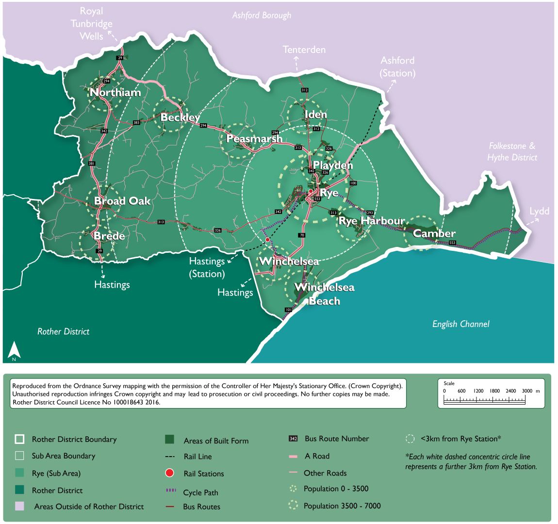
Figure 27: Rye and the Eastern Settlements Cluster
5.63 Figure 28 below individually lists the 'identified' development sites. Please see paragraph 5.32 above for an explanation of identified sites. For detail on the 'potential additional' sites, please refer to the draft HELAA.
Figure 28: Rye and the Eastern Settlements Cluster Development Strategy: Development Sites - Identified
|
Planning Permission/ Site Allocation reference |
Site Allocation |
Site Name, Settlement |
Parish |
Residential Units |
Employment Floorspace (sqm) |
|---|---|---|---|---|---|
|
Rye Neighbourhood Plan allocation Policy H3 |
Site currently allocated in Neighbourhood Plans |
Former Tilling Green School |
Rye |
20 |
0 |
|
Rye Neighbourhood Plan allocation Policy H5 |
Site currently allocated in Neighbourhood Plans |
Winchelsea Road (East Side) |
Rye |
10 |
500 |
|
Rye Neighbourhood Plan allocation Policy H6 |
Site currently allocated in Neighbourhood Plans |
Winchelsea Road (West Side) |
Rye |
20 |
1,000 |
|
Rye Neighbourhood Plan allocation Policy H7 |
Site currently allocated in Neighbourhood Plans |
Rye Creative Centre (Former Freda Gardham School Site), New Road, Rye |
Rye |
30 |
0 |
|
Rye Neighbourhood Plan allocation Policy H4 |
Site currently allocated in Neighbourhood Plans |
Rock Channel Site A - Rye |
Rye |
30 |
0 |
|
Rye Neighbourhood Plan allocation Policy H8 |
Site currently allocated in Neighbourhood Plans |
Former Lower School Site, off Ferry Road, Rye |
Rye |
50 |
0 |
|
RR/2017/2217/P |
Unallocated site with planning permission, or which are subject to a current planning application with a resolution to grant subject to the completion of a legal agreement. |
17 - 19 Tower Street, Rye |
Rye |
6 |
175 |
|
RR/2017/2097/P |
Unallocated site with planning permission, or which are subject to a current planning application with a resolution to grant subject to the completion of a legal agreement. |
Land south-west of Rye Hospital, Rye Road |
Rye Foreign |
34[26] |
0 |
|
DaSA allocation Policy RHA1 |
Sites currently allocated in the DaSA |
Land at Stoneworks Cottages, Rye Harbour |
Icklesham |
40 |
0 |
|
RR/2018/905/P, RR/2018/925/P, RR/2019/1841/P |
Unallocated site with planning permission, or which are subject to a current planning application with a resolution to grant subject to the completion of a legal agreement. |
Old Mears, Harbour Road, Rye Harbour |
Icklesham |
0 |
3,063 |
|
RR/2019/2850/P |
Unallocated site with planning permission, or which are subject to a current planning application with a resolution to grant subject to the completion of a legal agreement. |
Land at Churchfields Industrial Estate, Harbour Road, Rye Harbour |
Icklesham |
0 |
4,238 |
|
RR/2022/1157/P |
Unallocated site with planning permission, or which are subject to a current planning application with a resolution to grant subject to the completion of a legal agreement. |
The Atlas Business Park, Harbour Road, Rye Harbour |
Icklesham |
0 |
3,380 |
|
RR/2022/625/P |
Unallocated site with planning permission, or which are subject to a current planning application with a resolution to grant subject to the completion of a legal agreement. |
The Saltings - Site B, Harbour Road |
Icklesham |
0 |
1,244 |
|
DaSA allocation Policy IDE1 |
Sites currently allocated in the DaSA |
Land south of Elmsmead, Iden |
Iden |
12 |
0 |
|
DaSA allocation Policy PEA1 |
Sites currently allocated in the DaSA |
Land south of Main Street, Peasmarsh |
Peasmarsh |
45 |
0 |
|
Peasmarsh Neighbourhood Plan allocation Policy S1 |
Sites currently allocated in the DaSA |
Land east of Orchard Way, Peasmarsh |
Peasmarsh |
5 |
0 |
|
DaSA allocation Policy NOR1 |
Sites currently allocated in the DaSA |
Land south of Northiam Church of England Primary School, Northiam |
Northiam |
6 |
0 |
|
DaSA allocation Policy BEC2 |
Sites currently allocated in the DaSA |
Land South of Buddens Green, Beckley Four Oaks |
Beckley |
6 |
0 |
|
DaSA allocation Policy BEC1 |
Sites currently allocated in the DaSA |
Land East of Hobbs Lane, Beckley, Four Oaks, East Sussex |
Beckley |
14 |
0 |
|
DaSA allocation Policy BRO1 |
Sites currently allocated in the DaSA |
Land west of the A28, Northiam Road, Broad Oak |
Brede |
40 |
0 |
|
DaSA allocation Policy BRO2 |
Sites currently allocated in the DaSA |
Land south of the Broad Oak public house, Broad Oak |
Brede |
12 |
0 |
|
RR/2021/2947/P DaSA allocation Policy CAM1 |
Sites currently allocated in the DaSA |
Land at the Former Putting Green Site, Old Lydd Road, Camber |
Camber |
10 |
0 |
Explanatory Text:
5.64 Rye is a historic market town in the eastern half of the district near the Kent border. The town is the main service and employment centre in eastern Rother. Rye Harbour (within Icklesham parish) is a satellite village to Rye and is located to the southeast of the town. The area surrounding Rye is heavily constrained physically. The population of Rye Parish is recorded as being 4,480[27] in 2021. Some parts of Rye's built-up areas encroach into other adjacent parishes (Rye Foreign and Playden) and the population figure rises to over 5,064.
5.65 Rye is a successful market town attracting significant number of visitors in the summer months. As a Cinque Port town, the town centre around and including the ancient Citadel, forms the historic core, designated as a Conservation Area in 1969, and reviewed in 2006. The town centre is of very high architectural value, with a predominantly medieval street layout and building stock, while equally important is the town's visual appearance in the landscape, with the Citadel on a sandstone outcrop rising like an island above the low-lying surrounding salt marshes and tidal waters. The local economy of Rye and the surrounding areas is dominated by local tourism. Rye enjoys an abundance of hotels and guest houses located within the town itself.
5.66 The countryside surrounding Rye is subject to environmental designations, signifying its landscape character and conservation importance. Dungeness, Romney Marsh and Rye Bay are designated as a Special Protection Area (SPA) and wetland of international importance known as a 'Ramsar site'. In addition, much of the surrounding area to the north and west is classed as the High Weald NL, and there are several Ancient Woodlands.
5.67 The settlements within the eastern part of the district depend on Rye for wider facilities and services. Rye also functions as a key transport hub for travel outside of the district. While some of these settlements link radially to Rye, there is also a network of settlements which form a cluster, see Figure 27 above, with Rye as a key destination. This cluster is supported by existing bus services that could be enhanced through the development strategy of the Local Plan.
5.68 A sensitive and small-scale level of growth can potentially be delivered in the cluster of settlements that connect to Rye as a main transport hub. Associated sustainability improvements will be required to local services and facilities, as well as active travel measures.
Regulation 18 commentary:
5.69 It is important to note that at this moment in time, the housing and employment figures are indicative and provide 'potential' numbers based on the sites identified in the draft HELAA.
(1) 5.70 It is recognised that many of the potential additional sites require more detailed consideration of their impacts, including cumulative impacts. This work, together with specific allocation policies (where the parishes are not designated Neighbourhood Plan areas) will be developed after the Regulation 18 consultation stage. In seeking to maximise its potential supply, the Council wish to receive feedback through this Regulation 18 consultation on the opportunities for development that are proposed, and to develop its evidence base to support the most suitable and sustainable sites coming forward for development.
Question Box
(14) 65. What are your views on the vision for Rye and the eastern network settlements?
(8) 66. What are your views on the distribution and opportunities for growth in settlements within the sub-area in figures 25, 26 & 27?
(24) 67. What are your views on the potential sites identified in the draft HELAA that could accommodate more growth in Rye and the eastern network settlements?
(4) Vision for Northern Rother
Northern Rother's rural settlements and communities will continue to thrive, through small-scale sensitive residential development and growth in villages to create sustainable forms of development and protect and enhance the landscape character and scenic beauty of the High Weald National Landscape. This will ensure that health and wellbeing and community cohesion is maintained and improved.
While inevitably most rural residents have no choice but to travel primarily by car, connectivity between rural settlements and the Hastings-London rail line will be enhanced through promoting and improving sustainable and active transport infrastructure including walking, wheeling and cycling, enabling communities to lead healthy and active lifestyles.
The two stations at Etchingham and Robertsbridge will continue to act as transport hubs for wider villages in Northern Rother. There are opportunities for sensitive development in the short term, where sustainable and related to an existing settlement. Also, the area will continue to be served by the smaller Stonegate station.
Longer term (over a 30-year timeframe), the delivery of significant improvements to create a sustainable transport corridor, including bypasses to Flimwell and Hurst Green could open up opportunities for future development along the A21 corridor.
(1) 5.71 Figure 29 and Figure 30 below illustrate a potential development strategy for Northern Rother in terms of the numbers of dwellings and the amount of employment floorspace that could potentially be delivered over the Plan period. Please see paragraph 5.32 above for an explanation of the meaning of identified and potential additional growth.
(2) Figure 29: Northern Rother Settlements Development Strategy: Housing: Summary
|
Settlement Area |
Sustainability Coding |
Identified Level of Housing Growth |
Potential Additional Level of Housing Growth |
Total Potential Housing Growth (Identified + Additional) |
|
Etchingham |
Good sustainability |
0 |
16 |
16 |
|
Robertsbridge |
Good sustainability |
178 |
127 |
305 |
|
Ticehurst |
Good sustainability |
15 |
26 |
41 |
|
Burwash |
Fair sustainability |
37 |
6 |
43 |
|
Flimwell |
Fair sustainability |
9 |
108 |
117 |
|
Hurst Green |
Fair sustainability |
26 |
38 |
64 |
|
Staplecross |
Fair sustainability |
0 |
16 |
16 |
|
Burwash Common |
Poor Sustainability |
12 |
9 |
21 |
|
Total Growth |
277 |
346 |
623 |
|
Figure 30: Northern Rother Settlements Development Strategy: Employment: Summary
|
Settlement Area |
Sustainability Coding |
Identified Level of Employment Growth (sqm floorspace) |
Potential Additional Level of Employment Growth |
Total Potential Employment Growth (Identified + Additional) |
|
Etchingham |
Good sustainability |
0 |
0 |
0 |
|
Robertsbridge |
Good sustainability |
1,200 |
0 |
1,200 |
|
Ticehurst |
Good sustainability |
0 |
0 |
0 |
|
Burwash |
Fair sustainability |
0 |
0 |
0 |
|
Flimwell |
Fair sustainability |
0 |
2,850 |
2,850 |
|
Hurst Green |
Fair sustainability |
0 |
0 |
0 |
|
Burwash Common |
Poor Sustainability |
0 |
500 |
500 |
|
Ewhurst (parish) |
Very Poor Sustainability |
987 |
0 |
987 |
|
Total Growth |
2,187 |
3,350 |
5,537 |
|
(2) Figure 31: Northern Rother Settlements Development Strategy
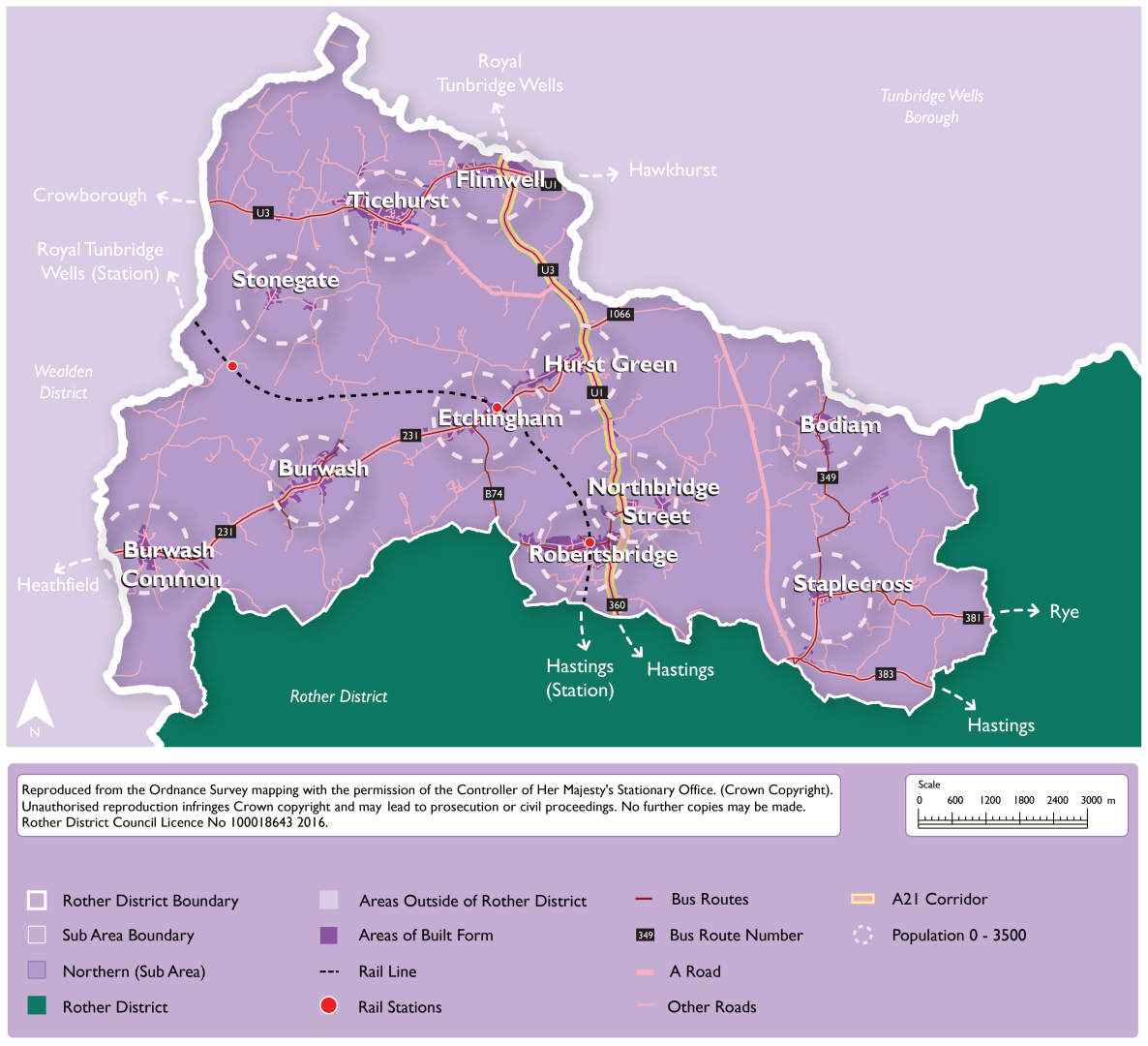
5.72 Figure 32 below individually lists the 'identified' development sites. Please see paragraph 5.32 above for an explanation of identified sites.
Figure 32: Northern Rother Settlements Development Strategy: Development Sites - Identified
|
Planning Permission/ Site Allocation reference |
Site Allocation |
Site Name, Settlement |
Parish |
Residential Units |
Employment Floorspace (sq m) |
|---|---|---|---|---|---|
|
RR/2017/582/P, Rother Local Plan allocation Policy VL1 |
Site currently allocated in the Rother Local Plan (2006) |
Land South West of Strand Meadow, Burwash |
Burwash |
30 |
0 |
|
RR/2021/1608/P |
Unallocated site with planning permission, or which is subject to a current planning application with a resolution to grant subject to the completion of a legal agreement. |
Ashwood Nursing Home, Fir Tree Bank |
Burwash |
12 |
0 |
|
RR/2021/431/P |
Unallocated site with planning permission, or which is subject to a current planning application with a resolution to grant subject to the completion of a legal agreement. |
Oakleys Garage, Burwash |
Burwash |
7 |
0 |
|
RR/2021/825/P |
Unallocated site with planning permission, or which is subject to a current planning application with a resolution to grant subject to the completion of a legal agreement. |
Land at Compass Park, Junction Road, Ewhurst |
Ewhurst |
0 |
987 |
|
RR/2021/2798/P |
Unallocated site with planning permission, or which is subject to a current planning application with a resolution to grant subject to the completion of a legal agreement. |
Land South of Lodge Farm, Hurst Green |
Hurst Green |
26 |
0 |
|
Salehurst and Robertsbridge Neighbourhood Plan allocation Policy HO2 |
Site currently allocated in Neighbourhood Plans |
Land to the south east of Heathfield Gardens, Robertsbridge |
Salehurst & Robertsbridge |
40 |
0 |
|
Salehurst and Robertsbridge Neighbourhood Plan allocation Policy HO2 |
Site currently allocated in Neighbourhood Plans |
Vicarage Land, Land south of the western end of Fair Lane, Robertsbridge |
Salehurst & Robertsbridge |
10 |
0 |
|
RR/2017/382/P, Salehurst and Robertsbridge Neighbourhood Plan allocation Policy HO2 |
Site currently allocated in Neighbourhood Plans |
Hodson's Mill, Northbridge Street, Robertsbridge |
Salehurst & Robertsbridge |
96 |
1,200 |
|
RR/2022/1850/P, RR/2022/283/P Salehurst and Robertsbridge Neighbourhood Plan allocation Policy HO2 |
Site currently allocated in Neighbourhood Plans |
Grove Farm, Robertsbridge, Site A |
Salehurst & Robertsbridge |
32 |
0 |
|
Ticehurst Neighbourhood Plan allocation Policy H2 |
Site currently allocated in Neighbourhood Plans |
Orchard Farm, Ticehurst Village |
Ticehurst |
5 |
0 |
|
Ticehurst Neighbourhood Plan allocation Policy H2 |
Site currently allocated in Neighbourhood Plans |
Singehurst, Pashley Road, Ticehurst Village |
Ticehurst |
10 |
0 |
|
Ticehurst Neighbourhood Plan allocation Policy H2 |
Site currently allocated in Neighbourhood Plans |
Wardsdown House, Flimwell |
Ticehurst |
9 |
0 |
Explanatory Text:
5.73 For the purposes of the development strategy, the parishes which form part of Northern Rother comprise Bodiam, Burwash, Dallington, Etchingham, Ewhurst, Hurst Green, Salehurst and Robertsbridge, and Ticehurst. Residents within these parishes and settlements are likely to use services and facilities outside of the district to the north in Tunbridge Wells Borough and the west in Wealden District.
5.74 Northern Rother is rural in its nature, with the largest villages being Ticehurst, Robertsbridge, Burwash and Hurst Green. Robertsbridge, along with Etchingham, have railway stations utilised for commuting and general travel south to Hastings and north to Tunbridge Wells and to London. They are more sustainable locations for sensitive growth, however this is dependent on there being appropriate sites available, having regard to the constraints of the area including in terms of landscape and flood risk.
5.75 The A21 provides road connections between the villages north and south. In the long-term, the A21 could become a sustainable travel corridor with busses given priority, linked to walking, cycling and wheeling routes. The Transport for the South-East (TfSE) Strategic Investment Plan identifies bypasses on the A21 at Flimwell and Hurst Green as necessary transport interventions to decarbonise transport in the south-east by 2050. This presents an opportunity for a longer-term vision (30 years or more) for the area, which may open up opportunities for development in the future beyond the plan period for this Local Plan.
5.76 Northern Rother experiences issues which are typical of rural communities, where some areas are isolated from services and facilities, and therefore there is a higher dependency on the private car for travel. There are opportunities for growth, albeit limited, in Northern Rother in settlements with brownfield sites and appropriate greenfield sites on the edge of villages. This must be balanced against the need to protect the strong landscape character of the wider area, as it is completely within the High Weald NL.
5.77 There is a clear need to support the rural economy and farming, and as such opportunities for growth, intensification, and redevelopment of commercial areas along with the diversification of farming will be supported where they are sensitive to landscape character. This can ensure that local businesses remain viable and job opportunities are available for local people.
5.78 It is important for the Local Plan to contain a clear vision for the rural communities of Northern Rother, ensuring that policies developed within the Local Plan reflect the Council's objectives and aspirations for the residents and businesses within rural communities, including farming communities.
Regulation 18 commentary:
5.79 It is important to note that the housing and employment figures are indicative and provide 'potential' numbers based on the sites identified in the draft HELAA.
5.80 It is recognised that many of the potential additional sites require more detailed consideration of their impacts, including cumulative impacts. This work, together with specific allocation policies (where the parishes are not designated Neighbourhood Plan areas) will be developed after the Regulation 18 consultation stage. In seeking to maximise its potential supply, the Council wish to receive feedback through this Regulation 18 consultation on the opportunities for development that are proposed, and to develop its evidence base to support the most suitable and sustainable sites coming forward for development.
Question Box
(19) 68. What are your views on the vision for Northern Rother?
(20) 69. What are your views on the distribution and opportunities for growth in settlements within the sub-area in figures 29, 30 & 31?
(38) 70. What are your views on the potential sites identified in the draft HELAA that could accommodate more growth in Northern Rother?
(11) 71. What are your views on a potential 30-year vision for the A21 transport corridor?
Summary of Growth for Opportunities for Sub-Areas
5.81 The following table (Figure 33) provides a summary of the growth opportunities in each of the sub-areas that were presented earlier in this chapter.
Figure 33: Summary of Growth Opportunities for Sub-Areas
|
Sub Area – Total Growth |
Identified Level of Housing Growth |
Potential Additional Level of Housing Growth |
Total Potential Housing Growth (Identified + Additional) |
|---|---|---|---|
|
Bexhill |
2,163 |
1,235 |
3,398 |
|
Hastings Fringes |
120 |
146 |
266 |
|
Battle and surrounding settlements |
403 |
265 |
668 |
|
Rye and the eastern settlements |
390 |
137 |
527 |
|
Northern Rother settlements |
277 |
346 |
623 |
|
TOTALS |
3,353 |
2,129 |
5,482 |
|
Sub Area |
Identified Level of Employment Growth (sqm floorspace) |
Potential Additional Level of Employment Growth |
Total Potential Employment Growth (Identified + Additional) (sqm floorspace) |
|---|---|---|---|
|
Total Growth - Bexhill |
39,572 |
19,684 |
59,256 |
|
Total Growth – Hastings Fringes |
6,600 |
0 |
6,600 |
|
Battle and surrounding settlements |
10,271 |
2,700 |
12,971 |
|
Rye and the eastern settlements |
13,600 |
500 |
14,100 |
|
Northern Rother settlements |
2,187 |
3,350 |
5,537 |
|
TOTALS |
72,230 |
26,234 |
98,464 |
Vision for the Countryside
New development will be strictly limited to that which supports local agricultural, economic, tourism or housing needs (especially for affordable housing) and maintains or improves the rural character.
Local rural economies and farming will continue to grow sensitively over time, including through diversification, while respecting the historic development pattern of rural communities, enabling and supporting healthy food production and eating.
The countryside and coast will have improved access and recreational and leisure facilities, compatible with the rural character of the area.
Explanatory Text:
5.82 The term 'countryside' is used here for those areas outside of villages and includes not only farmland and woodland but also scattered development outside the main confines of villages. There are areas of countryside within all five sub-areas set out in the preceding sections.
5.83 The countryside of Rother district is a defining characteristic. The countryside is a productive landscape, and the prime function of the countryside is agriculture and the production of food.
5.84 The countryside, including the undeveloped coast, also has high intrinsic amenity value, and is an important resource for nature conservation, leisure and tourism.
5.85 The vision for the Countryside seeks to balance the many diverse pressures and competing demands on the countryside, whilst ensuring the maintenance of its farming capacity and of its attractive landscape character, to create a living, working countryside.
Question Box
(13) 72. What are your views on the vision for Rother's countryside?
(7) 73. Are there any alternatives or additional points the Council should be considering?
Proposed Strategy: Sites for Gypsies, Travellers and Travelling Showpeople
Strategy Wording:
Provision will be made for 23 permanent pitches within Rother for Gypsies and Travellers between 2021 and 2040. These will be delivered as follows:
2021-2026: 9 pitches (14 pitches minus 5 pitches delivered since April 2021)
2026-2031: 4 pitches
2031-2036: 5 pitches
2036-2040: 5 pitches
Sites will be allocated in the Local Plan to provide for this number of pitches, taking into account any pitches granted permission in the interim.
Site selection will take into account the Local Plan objectives, the future needs of occupiers and the likely availability of sites for the intended occupiers. Sites should meet the criteria set in Policy HOU11 of the Local Plan.
Explanatory Text
(1) 5.86 The District Council has worked with the other East Sussex local authorities to commission a joint Gypsy, Traveller and Travelling Showpeople Accommodation Needs Assessment (GTAA) (2022). This study provides a summary of permanent and transit accommodation needs for gypsies, travellers and travelling showpeople across the county, and also across each district and borough, over the period 2021 to 2040.
5.87 The GTAA (2022) considers three definitions for gypsies and travellers when considering their accommodation need: an "ethnic definition" based on the ethnic identity of gypsies and travellers (not taking into account whether they have permanently ceased to travel or not), and two narrower definitions based on the Government's previous definition within the national Planning Policy for Traveller Sites (PPTS) (August 2015), which excluded those people who would have usually met the definition but who had permanently ceased to travel (for reasons such as ill health or old age, etc). Since the completion of the GTAA report the Government has amended the definition within the PPTS and it now aligns with the "ethnic" definition used in the PPTS. It should be noted that both the Human Rights Act 1998 and Equalities Act 2010 protect gypsies and travellers' cultural and ethnic way of life, including living in a caravan.
- Permanent site provision
5.88 Further to the above, it is appropriate for the Local Plan to seek to meet the accommodation needs of gypsies and travellers in the district who meet the "ethnic" definition. The GTAA (2022) calculated this need in Rother as: 14 permanent pitches between 2021 and 2026, a further four pitches to 2031, and a further five pitches in each of the 5-year periods 2031-36 and 2036-40 (total need 2021-2040: 28 pitches).
5.89 The GTAA found that accommodation need across East Sussex will arise largely from:
- families on unauthorised developments requiring authorised pitches;
- new family formations arising within existing family units (for example children growing up and starting their own families); and
- family units currently living in "bricks and mortar" accommodation who need to move to a pitch due to a psychological aversion to living in a house.
5.90 There may also be accommodation need arising for other reasons including new families moving into the area although this is difficult to quantify.
5.91 Currently, there is one County Council-owned gypsy and traveller site within Rother, at Robertsbridge, which consists of eight permanent pitches, each with its own amenity building. Pitches on this site are rented to gypsy and traveller households by the County Council. There are also five privately-owned gypsy and traveller sites providing a total of 15 pitches with permanent planning permission, and a further two sites (providing three pitches) with temporary planning permission[28]. Five of the pitches with permanent permission have been approved since the base date of the GTAA[29] and consequently, this figure has been deducted from the pitch requirement for 2021-2026. The resulting requirement, of nine additional pitches to 2026, is set out in the proposed policy above.
(1) 5.92 Sites identified to meet the need must be deliverable, either through being (or proposed to be) publicly owned, owned by gypsies/ travellers, have a willing landowner or, possibly, be part of a comprehensive development scheme that addresses a wider range of housing need.
- Transit site provision
5.93 Transit sites provide temporary accommodation for gypsy and traveller households travelling through the area. There are currently no transit sites in the district, and the only transit site in East Sussex is at Bridies Tan in the South Downs National Park. The GTAA (2022) found that over the period 2017-2021, an average of 34 unauthorised encampments took place across East Sussex each year and 18% of these were in Rother. However, on average, only one third of available pitches at Bridies Tan were occupied at any one time. This may be because households were not aware of the site, preferred not to use it, or required accommodation in a different location. As such, there may be a need for additional transit provision in other parts of the county. However, there is currently insufficient evidence to determine the number of additional transit pitches required, and consequently, the GTAA recommends that the Local Plan includes a windfall or criteria-based policy to assess any proposals that come forward for transit sites. This is covered by proposed Policy HOU11, which updates Core Strategy Policy LHN6 to include criteria relevant to transit sites.
5.94 The GTAA also recommends that all East Sussex local authorities adopt a "negotiated stopping" policy. This would allow traveller caravans to be sited at a suitable location for an agreed and limited period of time, and if necessary, with the provision of services such as waste disposal and toilets. Introducing a negotiated stopping policy would require the involvement of other services including the police and Environmental Health and as such is outside the scope of the Local Plan. However, the Council will continue to work with other local authorities and agencies to explore its implementation across the County.
- Travelling Showpeople provision
5.95 There are no travelling showpeople yards in the district. The GTAA found there is only one yard in the County, in Wealden District, and there is expected to be a demand for three additional plots to 2040 (although none in the period 2021-2026 and only one in the period 2026-2031). As the demand is expected to arise from natural population growth, it is expected that it will need to be met close to the existing yard in Wealden District. There is no specific evidence of travelling showpeople accommodation need within Rother, but a criteria-based policy (HOU11) will deal within any proposals for windfall sites (either permanent or transit) that do come forward.
- Boat dweller provision
5.96 The GTAA also considered the accommodation needs of boat-dwellers. It found that there is a lack of navigable waterways within East Sussex and few suitable locations for moorings. Consultation with stakeholders suggests that there is accommodation need for boat dwellers, however, a lack of evidence means that it is difficult to quantify the need. As such, the GTAA recommends that accommodation need for boat dwellers is met as it arises and considered on a case-by-case basis. There is very little history of proposals for boat dwellers' accommodation in the district and as such, a specific Local Plan policy is not necessary. Any proposals would be determined in accordance with the Local Plan as a whole.
Question Box
(10) 74. What are your views on the proposed policy for Sites for Gypsies, Travellers and Travelling Showpeople?
(22) 75. Are there any alternatives or additional points the Council should be considering?
Development Potential and Targets
(1) 5.97 The total amount of development in the 20-year (2020-2040) planning period of the Local Plan, as considered in this Regulation 18 version, comprises:
- development that has been constructed between 1 April 2020 and 31 March 2023;
- known completions and commencements on larger sites since 1 April 2023, where the sites are no longer considered through the HELAA;
- development with planning permission (or a resolution to grant permission subject to the signing of a legal agreement);
- sites that are currently allocated, but without planning permission, in the DaSA of a Neighbourhood Plan;
- sites identified for housing and employment in the HELAA that are known to be potentially available; and
- a windfall projection, indicating the number of houses which may be built on small sites (1-4 dwellings) not allocated or considered in the HELAA.
5.98 A windfall projection has been calculated for the district, based on recent data. This indicates that 39 dwellings can be delivered on small (1-4 dwelling) windfall sites per annum. This can be added to the total from the 2023/2024 monitoring year onwards. This adds 663 dwellings to the potential land supply.
5.99 In accordance with paragraph 5.96, Figure 34 provides a summary of the total amount of development potential in the district, at this Regulation 18 stage. The lower of the total range figures represents the number of dwellings or total floorspace on sites which have more planning certainty (are constructed, have planning permission, are allocated or are windfall projections). The higher figure represents the overall potential including additional HELAA sites known to be potentially available. This range in potential in also presented at a parish level in Figure 36.
Figure 34: District-wide development potential in the Local Plan
|
- |
Total dwellings |
Total employment floorspace (sq. m.) |
|---|---|---|
|
Constructed 1 April 2020 – 31 March 2023 |
802 |
5,927 |
|
Known completions and commencements on large sites since 1 April 2023[30] |
340 |
0 |
|
With Planning Permission[31] |
1,693 |
39,440 |
|
DaSA and Neighbourhood Plan allocations without permission brought forward |
1,660 |
32,790 |
|
Additional HELAA potential sites[32] |
2,129 |
26,234 |
|
Windfall projection (across the district) |
663 |
0 |
|
Total Range |
5,158-7,287 |
78,165-104,399 |
5.100 Based on the overall sustainability of settlements[33] and the development opportunities identified through the HELAA process, it is possible at this stage to identify the areas of the district where growth can be supported in principle. Figure 35, provides a summary of the level of housing growth opportunities by parish area. There are a number of parishes that have existing allocations for development (in either the Development and Site Allocations Plan or in Neighbourhood Plans). Any undeveloped allocated sites will be taken account of in the overall level of development proposed for settlements and parishes.
(3) Figure 35: Opportunities for housing growth by Parish area
|
Greater opportunities for growth |
Medium growth opportunities |
Low growth opportunities |
Limited growth opportunities |
|---|---|---|---|
|
Battle* |
Brede |
Beckley |
Ashburnham & Penhurst |
|
Bexhill |
Burwash* |
Camber |
Bodiam |
|
Rye* |
Catsfield |
Crowhurst* |
Brightling |
|
Salehurst & Robertsbridge* |
Hurst Green* |
Etchingham* |
Dallington |
|
Ticehurst* |
Icklesham |
Ewhurst |
East Guldeford |
|
Westfield |
Peasmarsh* |
Fairlight |
Mountfield |
|
Sedlescombe* |
Guestling |
Pett |
|
|
Iden |
Udimore |
||
|
Northiam |
Whatlington |
||
|
Playden |
|||
|
Rye Foreign |
*These parishes have either adopted or are preparing Neighbourhood Plans
5.101 The overall development potential in the district is presented below in Figure 36 at a parish level. A range is provided, where the higher figure includes potential sites identified through the HELAA process which are known to be available (subject to final confirmation). Relevant areas of built form in each parish area are presented under each parish.
(2) Figure 36: Proposed growth in each parish
|
Parish Area(s) |
Areas of Built form within the parish |
Level of Housing Growth (Range of Dwellings) |
Level of Employment Growth (Range of sqm floorspace) |
|
Ashburnham and Penhurst |
0 |
0 |
|
|
Battle |
Total |
293-518 |
1,895-4,595 |
|
Battle |
260-485 |
1,895-4,595 |
|
|
Netherfield |
33 |
0 |
|
|
Beckley |
Total |
20-32 |
0 |
|
Beckley |
0-12 |
0 |
|
|
King's Bank |
0 |
0 |
|
|
Four Oaks |
20 |
0 |
|
|
Bexhill |
Total |
2,163-3,398 |
39,572-59,256 |
|
Bexhill |
2,163-3,398 |
39,572-59,256 |
|
|
Lunsford Cross |
0 |
0 |
|
|
Norman's Bay |
0 |
0 |
|
|
Bodiam |
Bodiam |
0 |
0 |
|
Brede |
Total |
52-68 |
0 |
|
Brede |
0-5 |
0 |
|
|
Broad Oak |
52-63 |
0 |
|
|
Cackle Street |
0 |
0 |
|
|
Brightling |
0 |
1,861 |
|
|
Burwash |
Total |
49-64 |
0-500 |
|
Burwash |
37-43 |
0 |
|
|
Burwash Common |
12-21 |
0-500 |
|
|
Burwash Weald |
0 |
0 |
|
|
Camber |
Camber |
10-15 |
0 |
|
Catsfield |
Total |
35-60 |
0 |
|
Catsfield |
35-60 |
0 |
|
|
Catsfield Stream |
0 |
0 |
|
|
Crowhurst |
Crowhurst |
30-42 |
0 |
|
Dallington |
Total |
0 |
0 |
|
Dallington |
0 |
0 |
|
|
Wood's Corner |
0 |
0 |
|
|
East Guldeford |
East Guldeford |
0 |
0 |
|
Etchingham |
Etchingham |
0-16 |
0 |
|
Ewhurst |
Total |
0-16 |
987 |
|
Staplecross |
0-16 |
987 |
|
|
Cripp's Corner |
0 |
0 |
|
|
Fairlight |
Total |
0-35 |
0 |
|
Fairlight |
0 |
0 |
|
|
Fairlight Cove |
0-35 |
0 |
|
|
Guestling |
Total |
0-34 |
1,600 |
|
Guestling Green |
0-14 |
0 |
|
|
Friar's Hill |
0 |
0 |
|
|
Three Oaks |
0 |
0 |
|
|
Hastings Fringes |
0-20 |
1,600 |
|
|
Hurst Green |
Total |
26-64 |
0 |
|
Hurst Green |
26-64 |
0 |
|
|
Swiftsden |
0 |
0 |
|
|
Silver Hill |
0 |
0 |
|
|
Icklesham |
Total |
40-55 |
11,925 |
|
Icklesham |
0-15 |
0 |
|
|
Winchelsea |
0 |
0 |
|
|
Winchelsea Beach |
0 |
0 |
|
|
Rye Harbour |
40 |
11,925 |
|
|
Iden |
Iden |
12-25 |
0 |
|
Mountfield |
Mountfield |
0 |
0 |
|
Northiam |
Total |
6 |
0 |
|
Northiam |
6 |
0 |
|
|
Mill Corner |
0 |
0 |
|
|
Peasmarsh |
Total |
50-97 |
0-500 |
|
Peasmarsh |
50-97 |
0-500 |
|
|
Flackley Ash |
0 |
0 |
|
|
Pett |
Total |
0 |
0 |
|
Pett |
0 |
0 |
|
|
Pett Level |
0 |
0 |
|
|
Playden |
Total |
0-10 |
0 |
|
Playden |
0 |
0 |
|
|
Saltbarn Lane |
0 |
0 |
|
|
Poppyfield |
0-10 |
0 |
|
|
Houghton Green |
0 |
0 |
|
|
Rye |
Rye |
166-200 |
1,675 |
|
Rye Foreign |
Rye Hill |
34 |
0 |
|
Salehurst and |
Total |
178-305 |
1,200 |
|
Robertsbridge |
Robertsbridge |
82-209 |
0 |
|
Northbridge Street |
96 |
1,200 |
|
|
Sedlescombe |
Sedlescombe |
75-90 |
6,515 |
|
Ticehurst |
Total |
24-134 |
0-2,850 |
|
Ticehurst |
15-26 |
0 |
|
|
Dale Hill |
0 |
0 |
|
|
Flimwell |
9-108 |
0-2,850 |
|
|
Stonegate |
0 |
0 |
|
|
Cottenden |
0 |
0 |
|
|
Three Leg Cross |
0 |
0 |
|
|
Westfield |
Total |
90-140 |
0 |
|
Westfield |
50-100 |
0 |
|
|
Westfield Lane |
0 |
0 |
|
|
Hastings Fringes |
40 |
0 |
|
|
Whatlington |
Whatlington |
0 |
0 |
|
Udimore |
Udimore |
0 |
0 |
Question Box
(27) 76. What are your views on the district-wide development potential for the Local Plan up to 2040 which is presented in 4, 35 and 36?
Housing trajectory – Stepped delivery
5.102 The Council would require a considerable step change in housing delivery in order to deliver a significant uplift compared to current and historic delivery rates over the last ten years. Figure 37 provides a summary of the amount of residential development that has been delivered over the last 10 years. The Council's monitoring reports have indicated that delivery rates have been significantly impacted by the economy and local market, which has been further impacted by economic impacts of the coronavirus pandemic. While a number of current allocated sites have been permitted there have been significant delays in the build out of sites.
Figure 37: Net dwelling completions to 2022/2023
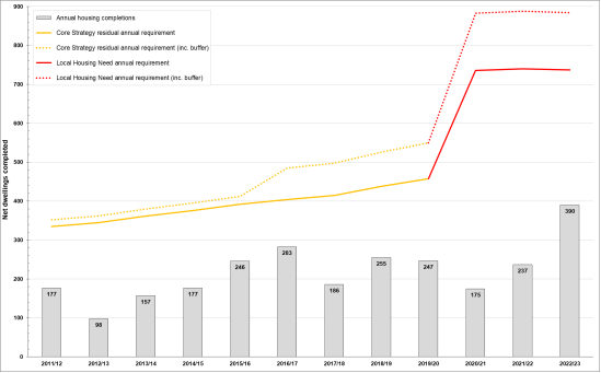
(1) 5.103 The Council will be undertaking a full viability assessment of the Local Plan along with some further local market analysis to support the existing Housing and Economic Development Needs Assessment. This will look to support the Council's intention to deliver a stepped increase in housing delivery with a greater amount of development coming forward towards the end of the planning period.
Question Box
(22) 77. Do you agree with the principal identified by the Council of achieving a stepped housing delivery with greater levels of delivery planned for later in the plan period?
Development Principles
(1) 5.104 The remaining sections of this chapter focus on principles, setting out policies which will influence development that comes forward. This includes proposed policies related to general development considerations, comprehensive development and masterplanning, small sites delivery, windfall delivery, development boundaries and strategic green gaps.
(2) Proposed Policy DEV1: General Development Considerations
Policy Status:
Strategic
New Policy?
No. Review of Policy OSS4 of the Core Strategy
Overall Priorities:
Green to the Core & Live Well Locally
Policy Wording:
In addition to considerations set out by other policies, all development should meet the following criteria:
- It meets the needs of future occupiers, including providing appropriate amenities and the provision of appropriate means of access for disabled users;
- It does not unreasonably harm the amenities of adjoining properties;
- It respects and does not detract from the character and appearance of the locality; and
- It is compatible with both the existing and planned use of adjacent land, and takes full account of previous use of the site.
Explanatory text:
5.105 All development should be capable of accommodating the reasonable expectations of likely occupiers, including the provision of indoor and outdoor space, personal safety and to not be unduly affected by adjacent intrusive uses and buildings. Development should also cater for practical needs, such as parking and access, refuse and recycling facilities and open space. These matters will also be covered in policies within the housing chapter of the Local Plan.
5.106 At the same time, the amenities of neighbouring properties need to be protected, in terms of loss of light and privacy, avoiding an overbearing presence and otherwise causing intrusion such as through noise, activity at unsocial hours and lighting for instance.
5.107 Environmental impacts need to be carefully addressed, such that landscape character is conserved, inappropriate fragmentation of the countryside avoided, important trees, woodlands and hedgerows retained, and where appropriate, supplemented by new landscaping, and wildlife habitats protected and encouraged. These requirements will also be supported by other environmental policies in the Green to the Core, landscape character and environmental management chapters of the Local Plan.
5.108 The need to ensure that infrastructure and facilities required to serve development will be provided is addressed in the infrastructure chapter of the Local Plan.
Question Box
(12) 78. What are your views on the Council's proposed policy on general development considerations?
(4) 79. Are there any alternatives or additional points the Council should be considering?
(1) Proposed Policy DEV2: Comprehensive Development and Masterplanning
Policy Status:
Strategic
New Policy?
No. Review of Policy DIM1 of the DaSA
Overall Priorities:
Green to the Core & Live Well Locally
Policy Wording:
Planning applications (whether in outline or full format) must relate to an entire development site to ensure a comprehensive approach, including where sites are in multiple ownerships.
When an outline application is submitted, a masterplan defining key parameters for the entire site must be submitted by the applicant to indicate how the overall development of the site can be achieved.
In circumstances, where it would speed up delivery, a planning application for part of a larger site may be permitted, but only where it demonstrably has regard to, and facilitates, an integrated scheme for development of the entire site through, a masterplan defining key parameters for the entire site as above.
In applying this policy, regard will be had to all relevant policies in this Local Plan to ensure appropriate provision, across the entire development site, of land uses, affordable housing, sustainable transport and access, green infrastructure (including biodiversity net gain and sustainable drainage) and other infrastructure (secured directly or through funding contributions).
Explanatory text:
5.109 The NPPF underlines the purpose of the planning system in achieve sustainable development. Development should be compatible with both the existing and planned use of adjacent land. This may involve bringing together land in different ownerships to ensure that the range of needs are met effectively within a logical overall area, or it may involve bringing together a mix of uses for an appropriate and sustainable approach to site development (for example commercial, community or recreational uses in addition to residential development). Mixed use developments are promoted in the NPPF, including as a means of supporting community facilities, new habitat creation or improved public access to the countryside.
5.110 Where a site comprises separate land ownerships, the expectation is that developers and landowners should work positively together to achieve wider goals of sustainable development and the full benefits for the local community. The need to demonstrate that proposals will secure the provision of infrastructure to serve a whole site is promoted by the proposed policy above. The approach to land-use mix should ensure the overall viability of proposals, while also ensuring that socially, economically and/or environmentally important elements, that will typically be less commercially attractive, are not "isolated". Hence, they may be required to be effectively cross-funded, normally by residential or other commercial elements, to enable the delivery of development that is sustainable and acceptable in planning terms.
5.111 The policy is to be applied in all cases where a comprehensive approach to development is necessary for the proper planning of an area. This will include site allocations and "windfall" sites that come forward for planning permission.
5.112 To ensure a comprehensive approach, a masterplan for the entire development site must be submitted where outline planning permission is applied for. This must set the vision and implementation strategy for the entire site and propose parameters relating to the scale and layout of development, mix of uses, affordable housing, sustainable transport and access; green infrastructure (including sustainable drainage and biodiversity net gain) and other infrastructure (secured directly or through funding contributions). This is to ensure that development meets the expectations of our Green to the Core and Live Well Locally Overall Priorities and the policies of this Local Plan.
5.113 Where the planning application does not relate to the entire site, it must be demonstrated that sub-division is necessary to speed up housing delivery.
Question Box
(16) 80. What are your views on the Council's proposed policy on comprehensive development and masterplanning?
(3) 81. Are there any alternatives or additional points the Council should be considering?
(6) Proposed Policy DEV3: Development Boundaries
Policy Status:
Strategic
New Policy?
Yes.
Overall Priorities:
Green to the Core & Live Well Locally
Policy Wording:
Development boundaries define the area within sustainable settlements where development will be permitted, provided it is consistent with this Local Plan.
Priority shall be given to reuse of brownfield sites, in order to make efficient use of previously developed land in sustainable settlements. Some greenfield development will be necessary in order to deliver housing and employment need, but this will be limited to inside development boundaries.
In the countryside (that is, outside of defined development boundaries), development shall be limited to that which accords with specific Local Plan policies or that for which a countryside location is demonstrated to be necessary. Brownfield development will be prioritised, in order to make efficient and sustainable use of previously developed land.
Explanatory Text:
5.114 Development boundaries differentiate between areas of built-up form within sustainable towns and villages, where further development[34], will be acceptable in principle, and the countryside.
5.115 Development boundaries are a key tool to positively focus growth on sustainable settlements and the networks and clusters of villages identified in the development strategy. This approach protects the surrounding countryside around them from unnecessary and intrusive development. The substantial High Weald National Landscape coverage of the district is a further key justification for carefully managing development in the countryside.
(1) 5.116 Within development boundaries, development will principally be on allocated and identified sites, together with other sites where proposals accord with relevant Local Plan policies. There is a presumption that infilling, redevelopment and changes of use will be acceptable subject to other policies of the Local Plan. This process of 'gentle densification' will help to support sustainable communities and Live Well Locally. Proposals within development boundaries are still subject to other policies to ensure that development does not adversely impact on other interests of acknowledged importance.
5.117 While land outside development boundaries is regarded as 'countryside' for planning policy purposes, it does include some villages, hamlets and farmsteads. A countryside location does not prevent appropriate development. The potential for development outside development boundaries to support vital rural communities and also conserve or enhance its intrinsic qualities is recognised. There are specific policies to promote a sustainable rural economy, including farming, tourism and to meet recognised local needs for facilities or affordable housing both in other policies of the Local Plan.
5.118 Development boundaries form policy lines and they do not necessarily represent the exact edge of settlements as such. While development boundaries will normally follow physical boundaries, on occasion, the full depth of property curtilages may be excluded to make clear a policy statement that back land or in-depth development is unacceptable, often because of its additional visual or amenity impact. This approach is consistent with the National Planning Policy Framework, which highlights the need to recognise 'the intrinsic character and beauty of the countryside' and the need to manage patterns of growth to realise opportunities for walking, cycling and use of public transport, with significant development focused on locations which are or can be made sustainable.
Regulation 18 commentary
5.119 Previous local plans and Neighbourhood Plans have defined the settlements and the extent of their development boundaries. This Local Plan will review each settlement's boundary, especially in relation to potential allocation sites. For the purposes of the Regulation 18 version, where we are consulting on potential sites, it is not possible to identify the settlements in which development boundaries may change. Figure 38 provides a table which shows the settlements which are expected to have development boundaries. All these settlements have designated development boundaries within the DaSA or Neighbourhood Plans, with the exception of Playden.
5.120 Development boundaries will be identified through the Local Plan, except where it is identified that Neighbourhood Plans are being progressed or reviewed.
Figure 38: Settlements with Development Boundaries
|
Development Boundaries in Local Plan |
Development Boundaries in Neighbourhood Plans |
|
Bexhill |
Battle |
|
Hastings Fringes |
Rye |
|
Beckley |
Burwash |
|
Brede & Cackle Street |
Burwash Common |
|
Broad Oak |
Burwash Weald |
|
Camber |
Crowhurst |
|
Catsfield |
Etchingham |
|
Guestling Green |
Flimwell |
|
Fairlight Cove |
Netherfield |
|
Icklesham |
Hurst Green |
|
Iden |
Peasmarsh |
|
Northiam |
Robertsbridge |
|
Pett |
Sedlescombe |
|
Playden |
Stonegate |
|
Rye Harbour |
Ticehurst |
|
Staplecross |
|
|
Three Oaks |
|
|
Westfield |
Question Box
(30) 82. What are your views on the Council's approach to development boundaries?
(6) 83. Are there any alternatives or additional points the Council should be considering?
(2) Proposed Policy DEV4: Retention of Sites of Community or Economic Value
Policy Status:
Strategic
New Policy?
No. Updated version of DaSA Policy DCO1
Overall Priorities:
Live Well Locally
Policy Wording:
Proposals that involve the loss or diminution of sites of community or economic value*, including those last in such use, must demonstrate that there is no reasonable prospect of a continued use, backed by:
- Evidence of a comprehensive and sustained marketing campaign, which clearly indicates a lack of demand for the existing use (or as an alternative economic use where the existing use is economic, or alternative community use in the case of an existing community facility), based on marketing, normally at least 18 months, that offers the land or unit/s for sale, or rental, at a realistic valuation of the site/premises for that use; and
- An independent viability assessment that clearly demonstrates that the unit is not or is not capable of being financially viable, including alternative economic or community facilities, where appropriate.
Proposals should not result in the loss of facilities or features which may undermine the viability of its use, including, but not limited to, car parks, gardens and function rooms.
*This includes a community facility, public house, local shops, tourist accommodation or attractions, and an employment use.
Explanatory Text:
5.121 The principle of the retention of sites for uses that require protection through the Local Plan is established through Policy HWB4 for sites of community use including local shops, services and facilities; Policy ECO2 in respect of employment uses; and Policy ECO5 for tourism activities, facilities and visitor accommodation. Main town centre uses within Town and District Centres, including retail uses, are protected separately through Policies ECO3 and ECO4. Collectively, these policies establish that sites of community and economic value, as defined by their respective policies, are normally retained, and their loss resisted unless it is evident that they cannot be maintained or that their continued use would perpetuate real harm to local amenities in some way. This policy sits alongside the above strategic policies by setting out the requisite marketing and viability evidence required to properly decide what constitutes no reasonable prospect of continued use.
5.122 To satisfy the policy test a comprehensive, sustained marketing campaign must be undertaken, offering the premises for sale or for rent, at a realistic valuation of the premises for the permitted use. Ordinarily, the marketing campaign should run for a period of at least 18 months before the planning application is submitted, with the premises offered for sale locally and regionally in appropriate publications including through trade agents. Details must accompany relevant planning applications, including a minimum of two independent valuations of the building in its current condition/state.
5.123 Sites must be advertised with the option of an alternative commercial or community facility, appropriate to the site and in line with other policies in the Local Plan. Where applications relate to a public house, the property must be advertised free of tie and restrictive covenant. Applications must also have full regard to the provisions set out in the Campaign for Real Ale (CAMRA) Public House Viability Test.
5.124 In terms of financial viability evidence, the Council will ordinarily require submission of trading accounts for the last three full years in which the business was operating on a full-time basis. In schemes affecting tourism accommodation, consideration will also be given to the adequacy of marketing measures to attract holiday lettings. Where an applicant wishes to make a case that a site is not, or is not capable of being financially viable, evidence must demonstrate the viability of alternative commercial or community facilities, where appropriate. The Council will normally obtain independent verification of the viability evidence submitted, to be undertaken at the developer's expense. Applications must also be accompanied with supporting information to demonstrate how the applicant has brought forward measures to improve viability of the business over the short/medium/long-term. The Council's National and Local List of Planning Application Requirements expands on the evidence to be supplied in support of a proposal under this policy.
5.125 In order that the sustainability of a community or economic use is not prejudiced, the above policy highlights the need to retain adequate amenity space (internal and external) and parking where their loss would threaten to undermine retention of a community or economic use. Areas such as gardens, car parks and function rooms attached to public houses and community facilities in particular can be subject to residential redevelopment pressures.
5.126 Development proposals that result in the loss of sites or premises currently or last used for community purposes are not subject to the requirements of this policy where they accord with Criterion (i) of Policy HWB4, whereby:
- alternative provision of equivalent or better quality is available in the local area, or;
- alternative provision of the equivalent or better quality will be provided in the local area and made available prior to the commencement or redevelopment of the proposed scheme, will not be required to also meet the requirements of this policy.
Regulation 18 commentary:
5.127 Community facilities, local shops, employment sites and premises, tourist attractions and accommodation, holiday sites and leisure facilities all play an important social and economic role within the district, making a positive contribution to maintaining and developing sustainable communities.
5.128 At the same time, commercial pressure for such sites and premises to change to alternative higher-value uses, notably housing, is strong. This often leads to local objections about the loss of facilities, particularly local shops and public houses, and the lack of sufficient job opportunities, especially for young people, when proposals come forward to convert or redevelop such sites for other purposes. These issues may be additionally compounded through the increase in population associated with changes of use to residential. The erosion of sustainable communities is at the heart of concerns.
5.129 Existing Local Plan policies DEC3 and DCO1 function to resist commercial pressures that result in the loss of sites of economic value, and indeed they have been successful in doing so, including where applications have gone to Appeal. Consequently, it is considered that this policy, and the overall approach in combination with DEC3, are to be taken forward into the new Local Plan.
Question Box
(11) 84. What are your views on the Council's proposed policy on the retention of sites of community and commercial value?
(6) 85. Are there any alternatives or additional points the Council should be considering?
(3) 86. What are your views on the range of uses that are covered by this policy?
(6) Proposed Policy DEV5: Development on Small Sites and Windfall Development
Policy Status:
Strategic
New Policy?
Yes.
Overall Priorities:
Green to the Core & Live Well Locally
Policy Wording:
A target of 20% of housing delivery will be delivered on small/medium sites (less than one hectare in size) across the district in each year throughout the plan period. This is supported by evidence of historic windfall[35] delivery of small sites (one to four dwellings) coming forward, and the identification of medium sized sites (five to ten dwellings) (this comprises sites that can accommodate five or more dwellings, but on a site size less than one hectare) in the HELAA.
There is clear potential for small/medium sites to be delivered through the neighbourhood planning process, evidenced by site availability in the HELAA. These sites will be an important source of residential growth within sustainable settlements.
A windfall development projection of 39 dwellings per annum has been projected for the plan period.
Explanatory Text:
5.130 The NPPF[36] is clear that the delivery of small and medium sized residential sites (of less than one hectare) is valuable to ensure a variety in housing land supply and has set a requirement for local authorities to meet 10% of its housing delivery on these types of sites. The proposed development strategy outlines that the Council will allocate a specific amount of residential development to settlements within Parish and Town Councils areas, which could then come forward as part of Neighbourhood Plans. These numbers are informed by the HELAA and the overall sustainability of settlements. Several potential sites that are identified to come forward, especially in the rural areas are on small and medium sized sites, especially those within locations in the High Weald National Landscape.
5.131 The importance of delivery on small sites is highlighted in the Council's Housing Land Supply Position Statement (December 2023) which demonstrates that 24% of housing delivery over the last 10 years has been on sites accommodating one to five dwellings, many of which are classified as windfall development. The Council is aware through its monitoring processes that windfall development forms an important part of its housing land supply and the Council will continue to rely on windfall development as part of its development strategy.
5.132 It is also likely that future Neighbourhood Plans will be able to identify smaller sites with no site size threshold to help meet this overall need. The Council will continue to develop a clear target for windfall delivery in support of its development strategy at the next stage of the Local Plan. Whilst the Council can project potential windfall delivery on smaller sites, it would still support larger windfall sites coming forward in accordance with other policies in the Local Plan.
Question Box
(17) 87. What are your views on the Council's strategy approaches to small sites and windfall development?
(3) 88. Are there any alternatives or additional points the Council should be considering?
(8) 89. What are your views on the Council, based on evidence, targeting a greater percentage of housing to come from smaller sites than the expected 10%?
(1) Proposed Policy DEV6: Strategic Green Gaps
Policy Status:
Strategic
New Policy?
Revision to Policy DEN3 of the DaSA
Overall Priorities:
Green to the Core & Live Well Locally
Policy Wording:
Within Strategic Green Gaps, development will be carefully controlled. Developments will only be permitted where they are unobtrusive and do not detract from the openness of the area having regard to the specific objectives of the gaps, as follows:
- to maintain the separate identity and distinctiveness between settlements;
- to maintain the strategic settlement pattern; and
- to prevent the coalescence of settlements.
Enhancement of the gaps through effective landscape management which strengthens and reinforces their significance as protected landscape areas will be supported.
The extent of each of the five strategic gap areas is described below:
Bexhill and Hastings/St Leonards Strategic Green Gap
The Gap between the two towns is relatively small, being particularly narrow along the A259 corridor, and hence any encroachment would be significant. It's location and accessibility means that it is highly vulnerable to development pressure. The accessibility of the Gap between Bexhill and Hastings has changed with the construction of Combe Valley Way, which increases the vulnerability of the countryside between Bexhill and Hastings/St Leonards. The Gap includes the Combe Haven valley and its tributary valleys in order to protect this open landscape between the two settlements.
Crowhurst and Hastings/St Leonards Strategic Green Gap
The construction of Combe Valley Way has increased the vulnerability of the Gap between Hastings/St Leonards and the village of Crowhurst. The area between the built-up edge of Crowhurst and the Hastings to London railway line is also included as it contributes to the open area between the settlements.
Battle and Hastings/St Leonards Strategic Green Gap
The Gap between Battle and Hastings/St Leonards provides an important function in maintaining the separate identities of Battle and the built-up area of Hastings/St Leonards. The break in the ribbon development between the edge of Telham and the Hastings Borough boundary at Breadsell Farm is highly vulnerable to change particularly in more open areas and the higher ground and ridges.
Fairlight and Hastings Strategic Green Gap
The Gap between the Hastings Borough boundary and the edge of Fairlight Cove provides an important function in protecting the general openness of the area between the Hastings Country Park and the edge of the settlements of Fairlight and Fairlight Cove. The area south of Battery Hill and Hill Road and to the east of Coastguard Lane, including The Close, is vulnerable to incremental change and infill development; hence, it is also included to conserve the area's open character.
Rye and Rye Harbour Strategic Green Gap
The open Gap between Rye citadel and Harbour Road industrial area/Rye Harbour village provides an important function in retaining their distinct identities. The area is fragile and vulnerable to encroaching development, as well as incremental changes in landscape management. The retention and protection of this Gap is important to the conservation and enhancement of local landscape character and views, notably with regard to the setting of the Citadel. The Gap also incorporates the sensitive riverside margin adjacent to the River Brede and River Rother.
Explanatory text:
5.133 Strategic Gaps are regarded to be of significant importance in terms of guiding the location of development. The particular objectives of the Gaps are:
- to maintain the separate identity and distinctiveness between settlements;
- to maintain the strategic settlement pattern; and
- to prevent the coalescence of settlements.
5.134 The protection of important areas of open space through local plans is an established policy tool. Development within these gaps is strictly limited to maintain their openness, although it does allow for agricultural buildings, conversions and the replacement of an existing building.
Question Box
(20) 90. What are your views on the Council's approach to strategic gaps and those that are identified?
(22) 91. Are there any other areas of the district that the Council should be considering, and if so, what evidence is available?
[20] Sites allocated in the DaSA and Neighbourhood Plans to meet growth up to 2028, which have not yet been developed.
[21] Although note that there is currently a planning application (RR/2021/3010/P) for a 64 bed care home on the site.
[22] 2021 census – town and civic parish
[23] This relates to a single site with an extant planning permission for a care home (C2 use) and is the residential C3 planning use equivalent figure, calculated from the number of permitted care beds, in accordance with the Planning Practice Guidance.
[24] Note that this figure could increase if potential sites which are currently not known to be "available" for development come forward. All potential sites, including those where the availability is unknown, are listed in the draft HELAA.
[25] This figure is an estimate, as the Neighbourhood Plan allocations do not include specific figures for employment floorspace.
[26] This site has an extant planning permission for a care home (C2 use) and is the residential C3 planning use equivalent figure, calculated from the number of permitted care beds, in accordance with the Planning Practice Guidance.
[27] 2021 census
[28] As at November 2023
[29] 1 April 2021
[30] where the sites are no longer considered through the HELAA.
[31] As at time of publication. Excludes sites completed after 31 March 2023.
[32] Includes sites which are understood to be available for development, but not suitable sites that are not known to be available.
[33] Rother's Settlement Study provides a detailed assessment of the overall sustainability of settlements across the district
[34] including redevelopment or intensification
[35] Unplanned development that is not allocated or identified in the Local Plan, typically on smaller sites.
[36] Para. 70 (December 2023 NPPF)