Rother Local Plan 2020-2040 (Regulation 18)
10. Landscape Character
(1) Proposed Policy LAN1: Rural Environments and Landscape Character
Policy Status:
Strategic
New Policy?
No - revised CS Policy EN1
Overall Priorities:
Green to the Core
Policy Wording:
The siting, layout and design of development should maintain and reinforce the natural and built landscape character of the area in which it will be located, based on a clear understanding of the distinctive local landscape characteristics.
Priority must be given to the conservation and enhancement of the district's national designated and locally distinctive landscapes and landscape features, including but not limited to:
- The High Weald National Landscape (which is also subject to Policy GTC9).
- The Romney Marshes, comprising of the distinctive low-lying levels to the east of the district with particular regard to the landscape setting of Rye and Winchelsea.
- The Pevensey Levels, comprising of the low-lying area of wetland meadows between Bexhill-on-Sea and Hailsham in Wealden District.
- Nationally designated historic sites including listed Parks and Gardens, Scheduled Ancient Monuments and the Registered Historic Battlefield at Battle.
- The undeveloped coast.
- Open landscape between clearly defined settlements, including the visual character of settlements, settlement edges and their rural fringes.
- Ancient Woodlands.
- Tranquil and remote areas, including the dark night sky.
- Other key landscape features across the district, including native hedgerows, copses, field patterns, historic field boundaries, ancient routeways, ditches and barrows, and ponds and water courses.
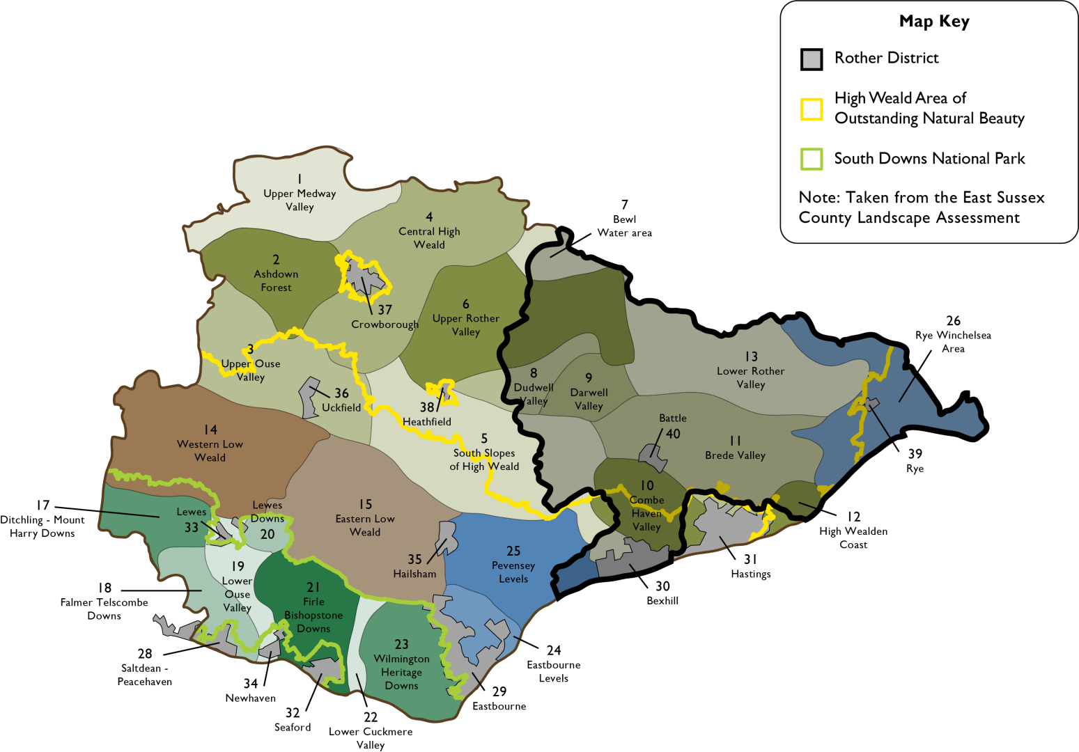
Figure 41: Local Landscape Character Areas in Rother and the surrounding area
Explanatory Text:
(2) 10.1 Rother's landscape is of great environmental and economic importance, as well as contributing to the sense of identity and health and well-being. The landscape is a combination of both cultural, historical and physical characteristics and components, which give rise to patterns that are distinctive to particular localities in the district and help to define a sense of place. The landscape therefore relies upon other influences including topography, land use, land management, ecology, and cultural associations.
10.2 The purpose of the policy is to provide protection for areas of high landscape value across the whole district. In addition, the High Weald National Landscape has a specific planning policy within the Green to the Core chapter of the Local Plan to reflect the importance and prevalence of the designated AONB within Rother.
10.3 Two predominantly rural areas with important landscape features comprise the Pevensey Levels and Romney Marshes. The Pevensey Levels are a low-lying tract of reclaimed wetland to the west of Bexhill at the western edge of the district that continues into Wealden District. They are typically a flat open landscape with extensively grazed wet meadows, largely windswept with a few trees. Widely spaced roads and isolated small settlements provide a sense of remoteness in this area, which is a priority habitat due to its designation as a Ramsar site and Special Area of Conservation (SCA).
10.4 The Romney Marshes are located around Rye to the east of the district and continue into Folkestone and Hythe District. This area is typically a flat open agricultural landscape of arable fields and wet pasture-land with distinctive drainage dykes, marshes and notable open skies. The area is also a priority habitat of the highest nature conservation value being designated as a Ramsar, Special Protection Area (SPA) and SAC. There is a sharp contrast between the shingle coast, low lying agricultural land and raised cliff in this wider area. The former sea cliffs mark the post glacial shoreline and the Royal Military Canal can be found at the base of the cliffs. The wider area is characterised by narrow straight roads and dispersed settlements with an open character and general feeling of remoteness. The coastal strip is also characterised by some 20th century development.
10.5 Another key rural area of importance is the Combe Valley Countryside Park, which is located between Bexhill and Hastings and forms an important Countryside Gap (Policy HWB7: Combe Valley Countryside Park).
10.6 The East Sussex Landscape Character Assessment (LCA) provides more detailed descriptions at a local level, reflecting the particular pattern of elements derived from geology, landform, topography, flora and fauna, physical features and settlement. The LCA Index Map, as it relates to Rother is reproduced at Figure 41 above. The key features and "action priorities" for each character area are identified in the Assessment document. This document will assist applicants in identifying the important characteristics of the landscape in which the development in proposed development is located, to meet the requirements of the policy.
Question Box
(13) 178. What are your views on the Council's proposed policy on rural environments and landscape character?
(5) 179. Are there any alternatives or additional points the Council should be considering?
Proposed Policy LAN2: Trees, Woodlands and Hedgerows
Policy Status:
Non-Strategic
New Policy?
Yes
Overall Priorities:
Green to the Core
Policy Wording:
Development must, where appropriate, enhance and expand the district's tree, hedgerow and woodland resource.
Development that would result in the unacceptable loss of, or damage to, or threaten the continued well-being of, locally valued and/or protected hedgerows, community orchards, veteran trees or woodland will not be permitted. The following criteria must be met:
- A CAVAT[113] assessment submitted with all applications impacting on individual or groups of trees in order to quantify the public amenity value.
- No net loss of hedgerows, as they form a key component of local ecological networks and ecosystem services.
- Where the loss of trees and/or hedgerows is considered acceptable, adequate replacement provision must utilise local and native species that are in sympathy with the character of the existing tree or hedge species in the locality and the site.
- Tree surgery work requiring consent must be undertaken in accordance with arboricultural best practice. All tree work must be undertaken in accordance with British Standard 5837: 2012 Trees in Relation to Design, Demolition and Construction.
- Details of soft landscaping details, including tree, hedge and wood planting where appropriate, must be provided with planning applications. Landscaping schemes should take into account local landscape character, ecological interests (including green infrastructure networks) and should include the planting of indigenous species where appropriate.
- Details of long-term maintenance and management plans must be provided to accompany soft landscaping proposals.
Explanatory Text:
(1) 10.7 Trees, woodlands and hedgerows form the backbone of the district's rural character, providing social and environmental benefits to local communities throughout the district, and contributing a great deal to the special character of the High Weald NL. Benefits include their positive impact on health and well-being, carbon sequestration, providing habitat and increasing biodiversity, and climate change adaptation and mitigation such as absorbing pollutants and reducing flash flooding by intercepting rainfall. They are important producers of oxygen and act as carbon sinks. In developments, trees and groups of trees can contribute to the successful integration of new buildings into the landscape, and the planting or retention of mature trees can significantly contribute to amenity as well as retaining important wildlife habitats. The retention and planting of trees should be considered at the design stage of all development.
(1) 10.8 The tree cover of Bexhill stands at an estimated 16% and shrub cover at 6%, giving a total canopy cover of 22% which covers an area of 750 hectares. A recent study in 2021[114] indicated that Bexhill should aspire to achieve 20% tree canopy cover by 2050. Street trees must also be protected and the value they bring to the district's towns in the form of biodiversity, carbon sequestration and shading is highly important.
10.9 The NPPF sets out in paragraph 180 b) that planning policies and decisions should contribute to and enhance the natural and local environment by 'recognising the intrinsic character and beauty of the countryside, and the wider benefits from natural capital and ecosystem services – including the economic and other benefits of the best and most versatile agricultural land, and of trees and woodland'.
10.10 Ancient woodland, defined as an area that has been wooded continuously since at least 1600 AD, must be considered when determining applications in order to avoid and reduce the impact of development. The Framework goes on to state in paragraph 180 c) that when determining planning applications, local authorities should ensure that 'development resulting in the loss or deterioration of irreplaceable habitats (such as ancient woodland and ancient or veteran trees) should be refused, unless there are wholly exceptional reasons, and a suitable compensation strategy exists.
10.11 Capital Asset Value for Amenity Trees (CAVAT) is a method of tree valuation used as a strategic tool and aid to decision making for tree stock as a whole but also can be applicable to individual cases, where the value of a single tree needs to be expressed in monetary terms. The value of individual trees is important not only in amenity value but also in terms of biodiversity and contributing to wildlife connectivity across the district. The application of this system recognises that both individual and groups of tree have significant value and any unavoidable loss will be sufficiently compensated.
Regulation 18 commentary:
10.12 National policy allows scope for the Local Plan to shape a tree, woodland and hedgerow protection policy that is appropriate for the district and recognises the significant contribution these habitats make to the varied landscape characters across the district. As such, the Council consider that this is an important area of planning policy that should be reflected in the Local Plan.
Question Box
(20) 180. What are your views on the Council's proposed policy on trees, woodlands and hedgerows?
(8) 181. Are there any alternatives or additional points the Council should be considering?
(4) Proposed Policy LAN3: Dark Skies
Policy Status:
Non-Strategic
New Policy?
Yes
Overall Priorities:
Green to the Core & Live Well Locally
Policy Wording:
The siting, layout and design of development must maintain and reinforce the sense of tranquillity of remote areas, especially locations within the High Weald National Landscape, through maintaining dark skies and avoiding unnecessary light pollution.
Development types with significant lighting requirements should be located on sites away from intrinsically dark rural skies, and away from wildlife sensitive areas such as ancient woodland.
Large areas of glazing in new building designs, especially wrap-around glazing and floor to ceiling windows, are discouraged, especially in rural areas with intrinsically dark skies.
Artificial lighting proposals must:
- Follow the Institute of Lighting Professionals (ILP) guidance on reducing obtrusive lighting and other relevant guidance to aid protecting dark skies, including ensuring that lighting designers use exterior light control environmental zone E1 to inform any proposed lighting in, or affecting the setting of, the High Weald National Landscape.
- Seek to protect wildlife-rich sites and habitats such as ancient semi-natural woodland from external lighting, and where lighting is needed, require minimised and ecologically informed lighting schemes regarding location, direction, lux levels, colour temperature and light fitting design.
- Seek to reduce light pollution, including glare and sky glow, by ensuring that flood-lit facilities such as sports pitches and car parks are turned off when not in use through agreements and planning conditions.
- Avoid new street lighting where possible and ensure any street lighting required for junctions on adopted roads is kept to the minimum necessary and adheres to best practice in term of location, illuminance and equipment design and light temperature, to avoid unnecessary skyglow and light spill.
Explanatory Text
(2) 10.13 The High Weald has some of the darkest skies with the least skyglow in the southeast and recognised by the International Dark Sky Association as being worthy of conservation. Dark skies are a valued characteristic of the countryside and contribute to the landscape qualities of the High Weald NL. The AONB Management Plan highlights 'Dark Skies' as being one of the character components that underpins the natural beauty of the High Weald and sets out two specific objections relating to this. The CPRE has found that only 22% of England has pristine night skies, completely free of light pollution; Rother District was found to be the 24th darkest district out of 326 local authority areas nationally.
(1) 10.14 Common sources of light pollution include sports and recreation venues, industrial and commercial areas, street and road lighting and illuminated signage, and internal light spill from dwellings, particularly those with large areas of glazing. Light pollution and nuisance is also caused at a domestic level from external security lighting and bulk head or 'welcome' lights at front and back doors. These external light sources are not all subject to planning control.
10.15 To limit the impact of light pollution, the NPPF states that proposals should consider:
- the need for the lighting, its duration, intensity and direction;
- the impact of light levels outside the development;
- the effect on the use or enjoyment of nearby buildings or open spaces;
- the impact of nature conservation, including any protected sites or species; and
- whether the development is in an intrinsically dark landscape where it may be desirable to minimise new light sources.
10.16 The NPPF states that planning policies and decisions should ensure that new development is 'appropriate for its location taking into account the likely effects (including cumulative effects) of pollution on health, living conditions and the natural environment…' Paragraph 185 c) sets out that policy should 'limit the impact of light pollution from artificial light on local amenity, intrinsically dark landscapes and nature conservation.'
10.17 The Institute of Lighting Professionals has published a guide to the issue of avoiding light pollution 'The Reduction of Obtrusive Light' https://theilp.org.uk/publication/guidance-note-1-for-the-reduction-of-obtrusive-light-2021/ which sets out that there are two ways of avoiding light pollution in developments, firstly at the design stage by designing out features that have the capacity to contribute to light pollution, and then ensuring that any required lighting follows the 'right light, right place' maxim.
10.18 The policy aims to avoid increased light pollution in rural areas from new developments, which can occur through the use of extensive glazing, external security lighting, new out-buildings and domestic lighting used to light-up homes and gardens at night. This impacts on the migration, feeding, breeding and circadian rhythms of all animal groups including invertebrates, mammals, birds and amphibians.
10.19 Furthermore, skyglow from nearby built-up areas reduces views of celestial bodies such as the Milky Way ad Orion, leading to a loss of public connection and enjoyment of the night skies. The policy intends to not only mitigate the impact of light pollution on the visibility of the night sky but the harmful impact on human health, wildlife and biodiversity.
10.20 The benefits from the policy are likely to include an improvement of the district's environment and night-time tranquillity, less harmful impacts on the area's nocturnal wildlife arising from a reduction of artificial light overspill, and potential for an increase in tourism as the district's reputation for intrinsic dark skies grows.
(2) 10.21 It is recommended that the consideration of lighting design should take place at the pre-app stage where relevant in order to ensure, along with an updated validation list, that lighting design is integral part of the planning decision.
Question Box
(24) 182. What are your views on the Council's proposed policy on Dark Skies?
(15) 183. Are there any alternatives or additional points the Council should be considering?
[113] Capital Asset Value for Amenity Trees (CAVAT)
[114] Bexhill I-Tree Study Bexhill i-Tree study and a tree planting strategy – Rother District Council