Rother Local Plan 2020-2040 (Regulation 18)
Why do we need a Local Plan?
(22) 1.1 The Local Plan contains the vision, strategies and policies to steer development decisions across the Rother District. It is the starting point for all decisions about new development and ensures that the planning system is plan-led.
(3) 1.2 The National Planning Policy Framework (NPPF)[1] requires local planning authorities to have an up-to-date plan that covers a period of at least 15 years from the date it is adopted.
(1) 1.3 The Council is committed to delivering a new Local Plan that links closely to the Corporate Plan and other important Council strategy documents.
What will the Local Plan deliver?
(7) 1.4 This is the Regulation 18[2] public consultation version of the Rother District Local Plan. Once adopted, it will replace Rother's Core Strategy (2014) and Development and Site Allocations (2019) Plans.
1.5 The primary purpose of this new Local Plan is to set out the long-term strategy and planning policies for Rother District to 2040. The Local Plan includes a vision for the district, which describes what the Plan is aiming to achieve and what the district should look like by 2040.
(4) 1.6 The Local Plan's vision has emerged from the key issues that have been identified in the evidence base and through early engagement and informal consultation. The Council recognises the key role that the Local Plan plays in responding to the Council's declared Climate Emergency; delivering the Council's housing, economic, community and infrastructure needs; and protecting the special landscapes, habitats and heritage of the district. It is important that the Local Plan strikes the right balance in the best interests of the district's residents and businesses.
(6) 1.7 The plan sets twin overall priorities ('Green to the Core' and 'Live Well Locally') to meet that vision, which are important to the overall delivery of the plan, along with ten strategic objectives that the plan seeks to deliver.
(1) 1.8 This leads to the creation of the Local Plan's development strategy for both the whole district and five sub-areas within it. It proposes a distinct strategy focussed on networks and clusters of towns and villages to respond to our twin priorities.
(3) 1.9 The Local Plan will be supported at the local level by Neighbourhood Plans, which give communities the power to develop a shared vision for their local area and set specific policies within the context of the Local Plan's strategic policies. Seven[3] Neighbourhood Plans have been made (adopted) and details of these can be found on the Council's Neighbourhood Planning webpage. The Council will work closely with neighbourhood planning groups in the drafting of this Plan and will continue to support Neighbourhood Plans alongside the Local Plan review.
(2) 1.10 A wide range of evidence base documents are being prepared to support the development of the Local Plan. This version of the Plan takes into account evidence that is available at this stage. The scope and detail of the supporting evidence base is set out in Background Topic Papers and this can be found on the Local Plan Review webpage.
(6) 1.11 The Council has already undertaken some informal engagement on the Local Plan in the lead up to the publication of this consultation version. This involved specific stakeholders[4] and Rother's Councillors, and is summarised on the Council's Local Plan Review webpage. This period of early engagement has resulted in the development and understanding of the Local Plan's Overall Priorities, objectives, and strategic and non-strategic policies[5].
What is the Regulation 18 Version of the Local Plan?
(5) 1.12 We are required by law to consult on our draft plan. This consultation offers the chance to respond to, and comment on, this draft document.
(2) 1.13 At the end of the consultation, we will look at every one of the comments received. The comments will help us pull together the 'Submission Version' of the Local Plan.
(2) 1.14 The Submission Version of the Plan will also go through a formal consultation process, known as 'Regulation 19', which we expect to take place in early 2025. The submission version of this plan will then be submitted to the Planning Inspectorate for an 'Examination in Public'.
(3) 1.15 This draft plan seeks to be ambitious and bold in its response to the climate, biodiversity, health and wellbeing, and housing affordability challenges that we face.
1.16 It proposes full policy wording and explanatory text where there is a clear and evidenced policy direction that the Council wishes to take. Where the Council's evidence base is still in development, proposed policy approaches are set out.
1.17 'Regulation 18 commentary', relevant to this version of the Local Plan, is provided to assist understanding of the policies and policy approaches set out.
1.18 In most sections of the Plan, specific consultation questions related to the policy areas and themes are asked. The questions seek to gather feedback and assist policy development. While we would welcome specific feedback on these areas, any other comments can be made on this Local Plan by referencing the Section heading, paragraph number, page number etc in your representation.
What National Policy, Strategies and Plans need to be considered?
(5) 1.19 The NPPF sets out the overarching planning policy requirements which the Local Plan must meet, including a justification for the level of development proposed. This seeks to balance local housing and economic development needs against heritage, landscape and environmental protections.
1.20 The Local Plan must take account of current Planning Practice Guidance (PPG) from the Government. Alongside this, the Local Plan takes account of other national policy guidance from statutory organisations[6] such as the Marine Management Organisation, Natural England, National Highways and the Environment Agency. Other relevant policies, plans and programmes which may impact on the Local Plan have been taken into account and assessed through the Sustainability Appraisal/Strategic Environmental Assessment (SA/SEA) Scoping Report.
(1) 1.21 The Local Plan should not merely repeat national planning policy. Instead, it must set out strategic and non-strategic policies which are important to Rother's local context. Where it is relevant to adopt national standards or national policy approaches, the Local Plan identifies this in each relevant section.
The Geography and Population of Rother District
(1) 1.22 Rother District covers some 200 square miles.
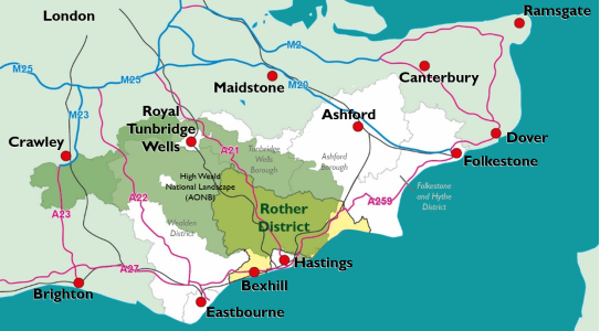
1.23 Figure 1 shows Rother in a regional context, along with the district's neighbouring planning authorities and their geographical relationship with the High Weald National Landscape (NL) and main transport connections.
(1) Figure 1: Rother context map
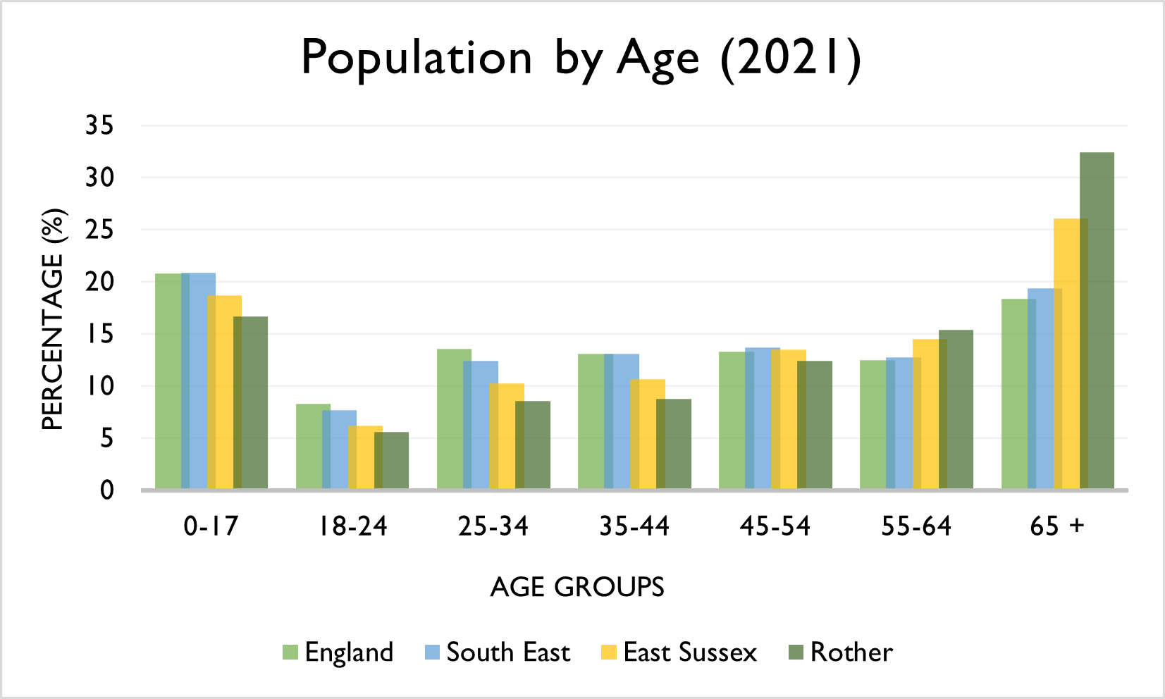
(1) 1.24 Some 93,111 people currently live in Rother (ESiF, data from Census 2021), many dispersed across the rural area, but with nearly half living in Bexhill. The broad age structure of residents today is shown in Figure 2 below. There is a higher than average proportion of people 65 years old and over in Rother, especially in parts of Bexhill, and this proportion is predicted to increase in the future. The Council has joined the World Health Organisation's Global Network of Age-Friendly Cities and Communities, as part of its commitment to ensuring that Rother is a great place to grow old for all its residents.
(2) Figure 2: Age structure of Rother residents (ESiF, 2021)
(2) 1.25 Rother wraps around Hastings' boundary from Bexhill in the west, to Fairlight in the east. Rother and Hastings are one functional economic and housing market area, showing, in many ways, that those who live, work and visit here are part of the same community.
1.26 The 2019 Index of Multiple Deprivation gives an overall rank for Rother of 135 out of the 317 English local authorities, with the most deprived local authority ranked as 1. However, there is wide disparity between areas of the district that are affluent and those that are deprived.
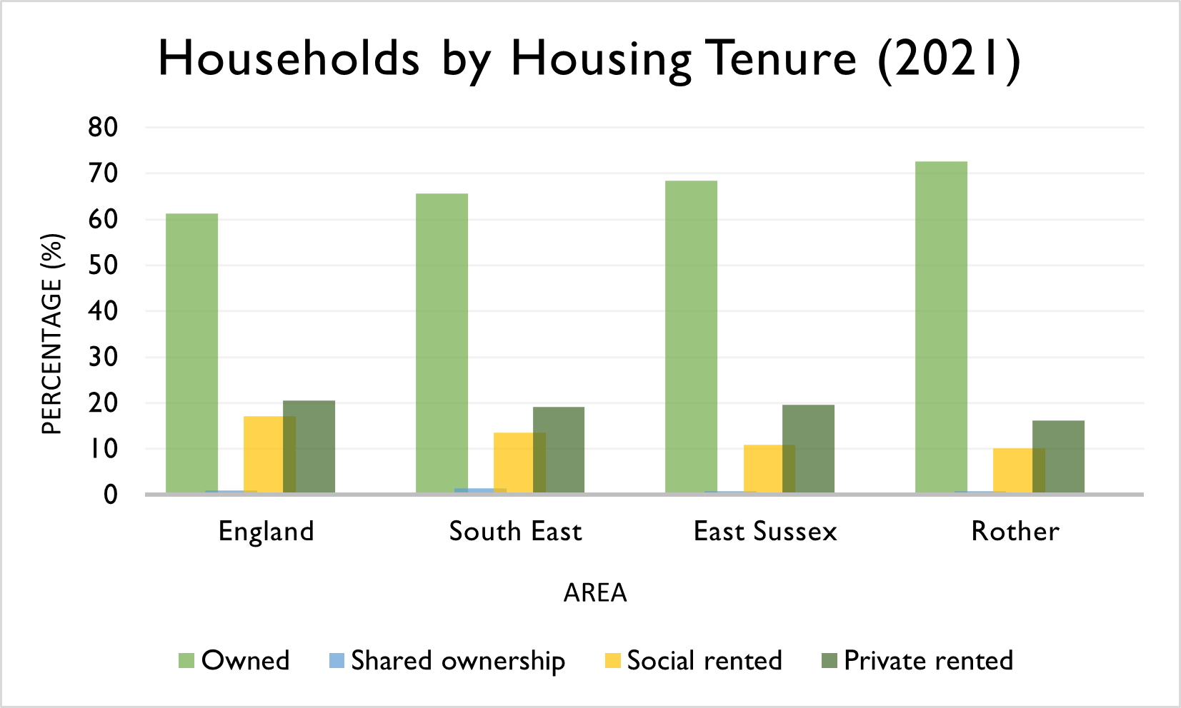
1.27 Rother has a higher proportion of owner occupancy and a lower proportion of social housing compared to the national, regional and county averages.
1.28 Figure 3 shows from the 2021 Census data on ESiF, in Rother, 72.7% of houses in Rother are owned and just 10.2% are social rented. Equivalent figures elsewhere are: England & Wales (61.3%/17.1%), South East (65.7%/13.6%) and East Sussex (68.4%/11.0%).
(1) Figure 3: Households by Housing Tenure
(4) 1.29 Rother benefits from some of the most beautiful countryside and coastline in South East England and contains the historic market towns of Battle and Rye, the Victorian/Edwardian seaside town (and administrative centre) of Bexhill and many picturesque villages.
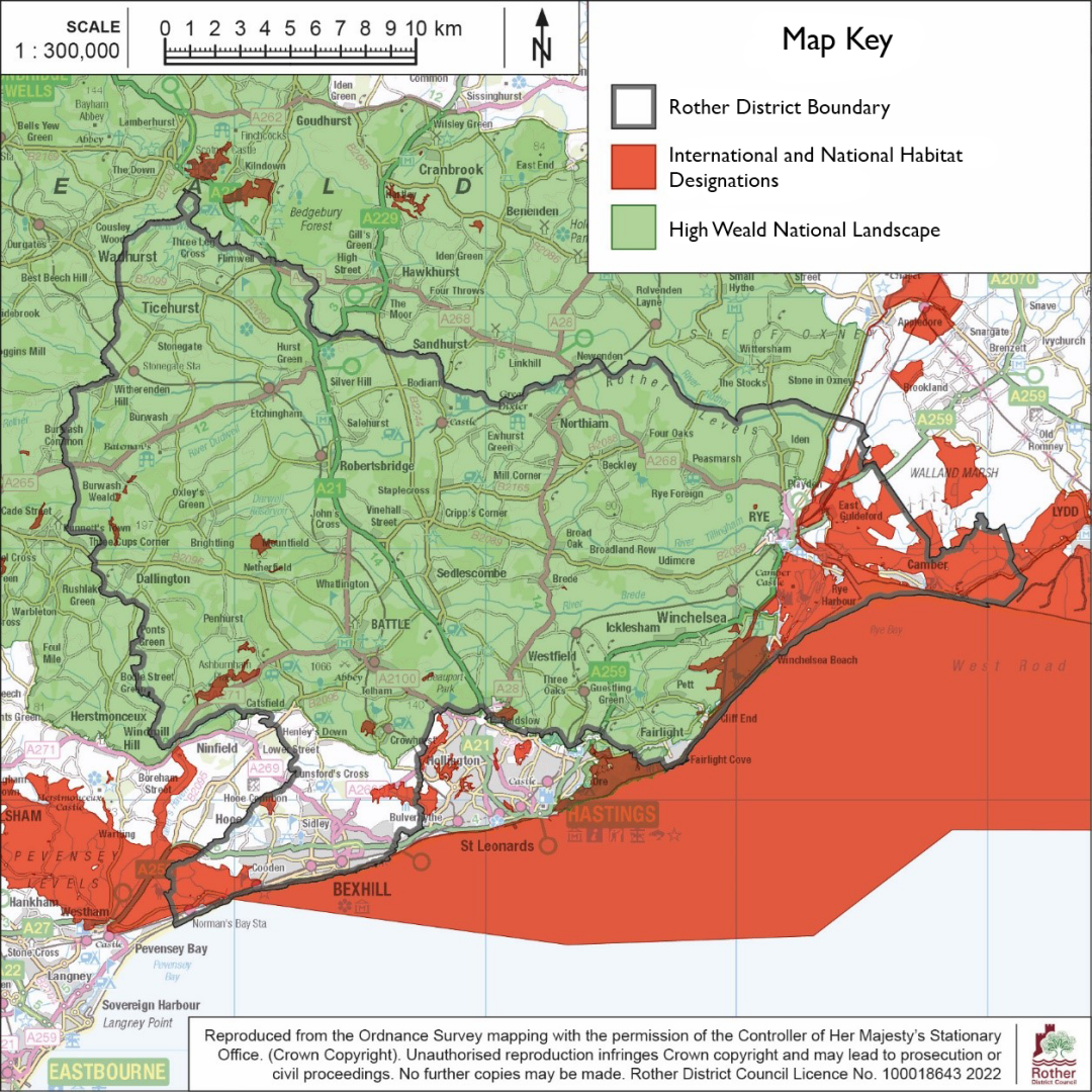
(2) 1.30 83% of the district is within the High Weald National Landscape (NL), a designated 'Area of Outstanding Natural Beauty'. The High Weald NL is one of the best remaining examples of a medieval landscape in Northern Europe consisting of woods, small fields, farmsteads and ancient routeways.
(3) 1.31 Rother's historic environment is highly valued, with statutory protection of over 2,000 listed buildings, ten Conservation Areas, a number of Scheduled Ancient Monuments and the 'Historic Battlefield' at Battle. There are also many other non-designated historic buildings – particularly farmsteads. Its recognised scenic beauty and heritage play a large part in attracting significant levels of tourism.
1.32 The Pevensey Levels, straddling the south-western boundary of the district, is a 'Ramsar' site, designated for its international importance as a wetland habitat and a Special Area of Conservation (SAC).
1.33 On the south-eastern boundary, the Dungeness Complex of Habitats Sites comprises three overlapping international designations – the Dungeness, Romney Marsh and Rye Bay Special Protection Area (SPA) and Ramsar Site and the Dungeness Special Area of Conservation (SAC). There are also many Sites of Special Scientific Interest (SSSIs) in Rother.
(1) 1.34 These habitat designations mean that in addition to the 83% of the district in the High Weald NL, a further 7% is either nationally or internationally protected for its habitat value.
Figure 4: Protected Landscape and Environmental designations
(2) 1.35 The extent of Ancient Woodland is also significant, covering 16% of the district – the greatest of any district in the South East (see the Ancient Woodland Inventory 2010). This is an irreplaceable habitat of ecological value for nature recovery as well as carbon sequestration and cultural and landscape importance.
(1) 1.36 The partly low-lying and coastal nature of the district, along with its intricate network of ridges and valleys, make it particularly vulnerable to flooding. The predominant flood risk comes from the sea, rivers and watercourses, although the district also suffers from surface water flooding. The majority of the coast benefits from flood defences. Flood risk areas will be mapped and assessed in the Council's Strategic Flood Risk Assessment, which is currently in production.
Joint Statement agreed with Hastings Borough Council
Together, both Councils form a strongly defined Housing and Functional Economic Market Area. Hastings, as one of East Sussex's largest towns, provides a strong draw for many residents within Rother, with the inhabitants of many towns and villages visiting Hastings to access wider services and facilities.
The Councils understand these interactions and will continue to work closely to develop evidence bases in support of their respective Local Plans. We will continue to look for opportunities for joint studies and are working together to assess the impacts of our development strategies to ensure that the needs of the wider Housing and Functional Economic Market Area can be best met.
Both Councils will aim to shape development to radically reduce carbon emissions by aligning growth and infrastructure to enable our communities to live well locally, while enhancing the natural and built environment, and adapting to the effects of climate change.
(1) 1.37 Rother District Council (RDC) is working closely with Hastings Borough Council (HBC) because of their geographical and economic relationship. Through early engagement, both Councils have discussed opportunities for joint working, including joint approaches to each authority's evidence base and evolving development strategies.
1.38 The Councils are committed to continuing this joint working relationship as our respective Local Plans progress. The joint statement above reflects our clear intention to develop and action matters of cross-boundary importance and most importantly, explore joint opportunities to maximise housing delivery.
Using the Local Plan
(5) 1.39 The Local Plan is divided into specific chapters which help to present different themes and areas of importance of the Local Plan. The following table (Figure 5) helps explain how the Local Plan is structured.
(2) 1.40 Proposed policy wording and explanatory text is set out in this draft for chapters 1 to 12 where there is a clear and evidenced policy direction that the Council wishes to take. Individual site allocation policies will form chapter 13, but this is not part of this Regulation 18 consultation because we wish to consult on the development strategy and draft Housing and Employment Land Availability Assessment (HELAA) before final site selection and specific site allocation policies.
(9) Figure 5: Structure of the Local Plan
Chapter
Description
- Introduction (this chapter)
Explains why the Council is preparing a Local Plan, the Regulation 18 public consultation version and the district's geographical context.
- Vision and Objectives
Sets out the Council's vision for the Local Plan, its twin Green to the Core and Live Well Locally overall priorities, and the key objectives that the Local Plan should deliver.
- Green to the Core
Sets out policies relating to the climate emergency, biodiversity crisis and the High Weald National Landscape which meet the Local Plan's Green to the Core overall priority.
- Live Well Locally
Sets out polices for compact development, facilities and services, active and public transport, the public realm and built form which meet the Local Plan's Live Well Locally overall priority.
- Development Strategy and Principles
Presents the Council's proposed strategy for growth, with a consideration of alternatives, along with specific visions for five sub-areas. Sets out policies relating to general development principles, development boundaries, comprehensive development and strategic gaps.
- Health and Wellbeing
Contains policies to improve the health and wellbeing of the community within the overall priority to Live Well Locally.
- Infrastructure
Explains the importance of infrastructure delivery to support growth in the Local Plan in relation to transport, community facilities and green and blue infrastructure.
- Housing
Contains policies relating to new residential development to ensure mixed and balanced communities and the delivery of affordable housing, and policies to guide existing householder applications.
- Economy
Contains policies relating to commercial development, protecting the loss of commercial use, identifying retail and leisure need, and planning for tourism and rural industries.
- Landscape Character
Contains policies relating to rural areas and their landscapes, trees and woodlands and dark skies.
- Environmental Management
Contains policies relating to flooding and sustainable drainage, coastal issues, biodiversity, including designated sites and pollution.
- Heritage
Sets out policies to preserve the historic built character across the district as well as policy for signs and advertisements.
- Site Allocations
Will set out policies for individual site allocations for development, based on the proposed development strategy in chapter 5 and the draft Housing and Employment Land Availability Assessment (HELAA). This proposed chapter is not part of the Regulation 18 consultation because we wish to consult on the development strategy and draft HELAA before final site selection and specific site allocation policies.
[1] National Planning Policy Framework, December 2023
[2] From the Town and Country Planning (Local Planning) (England) Regulations 2012 (as amended)
[3] Battle, Burwash, Crowhurst, Rye, Salehurst & Robertsbridge, Sedlescombe, and Ticehurst.
[4] Statutory organisations, neighbouring local planning authorities, infrastructure bodies and other prescribed bodies for the purposes of the Duty to Cooperate.
[5] Strategic and non-strategic policies are listed in Appendix 1.
[6] This list is by no means exhaustive, and various guidance has been considered where referenced in the Local Plan and supporting Background Papers.