Rock Channel Rye Development Brief
Opportunity Areas
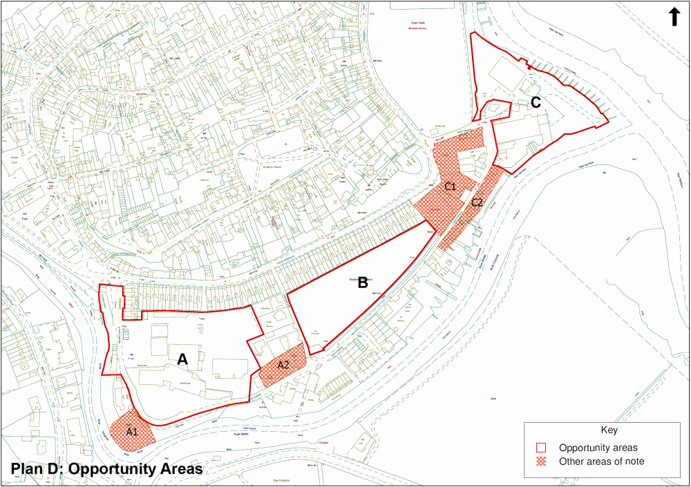
76. Plan D, below, shows three sites within the Rock Channel area identified as having particular potential for re/development:
- Site A - Jempsons/Bournes area including River Cafe
- Site B - allotments
- Site C - fishing peninsula area
Plan D: Opportunity Areas
77. The following section sets out the specific considerations for these identified opportunity areas which, along with the overarching development principles set out in the previous section, should be used to guide development proposals for the sites.
78. Based on the appraisal of the Rock Channel area, Plan D also identifies additional areas (Areas A1, A2, C1 and C2) where there might be scope for beneficial change in the longer term. Any such potential is clearly subject to the intentions of land owners and lessees and the brief includes no firm proposals. Rather, there is a simple discussion of these areas at the end of the sections on Site A and Site C respectively.
Site A - Jempsons/Bournes area including River Cafe
Site Assessment
79. This area, identified on Plan D, is approximately 1.69ha.
80. The area is in a number of private land ownerships and is in commercial use. The main body of the site is used for a road haulage business (Jempsons), a removal/shipment company (UTS Bournes) and auction rooms. The area has a strong commercial character at present, with large, bulky, modern warehouse-style structures and extensive unattractive areas of tarmac and concrete hard-standing. On the western edge of the area, bordering the river, is the River Café which makes active use of its riverside setting and acts as a visual draw from the Strand Quay area.
81. The defined opportunity area is bordered by houses at St Margarets Terrace, South Undercliff and fronting Shipyard Lane as well as the bungalow Bridge Point. To the south of the opportunity area is a grassed and bunded area which forms part of the flood defence, beyond which is Rock Channel itself.
82. Access through the site is by means of the unmade road which also forms part of the public right of way through the wider area, which joins the A259(T) at St Margarets Terrace. Generally the area appears inhospitable to pedestrians and visitors; the public footpath is poorly signed and the mix of uses here does not encourage public access.
83. There are clear visual and physical links between this site and the Strand Quay area where people congregate to visit the shops, cafes, restaurants and other facilities as well as to enjoy being by the riverside.
Specific Development Considerations
Overall Approach
84. Redevelopment in this area should capitalise on the benefits of its location, namely:
- the proximity of Strand Quay and the concentration of activity there;
- the sense of containment provided by the river; and
- the visual and physical links to the Citadel.
Further, redevelopment should exploit the potential for:
- a better link between Strand Quay and the Fishing Quay.
85. The inter-related nature of the separately owned parcels of land here means that there is an imperative for collaborative working between land owners to prepare a comprehensive scheme for redevelopment.
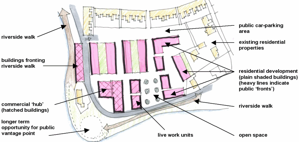
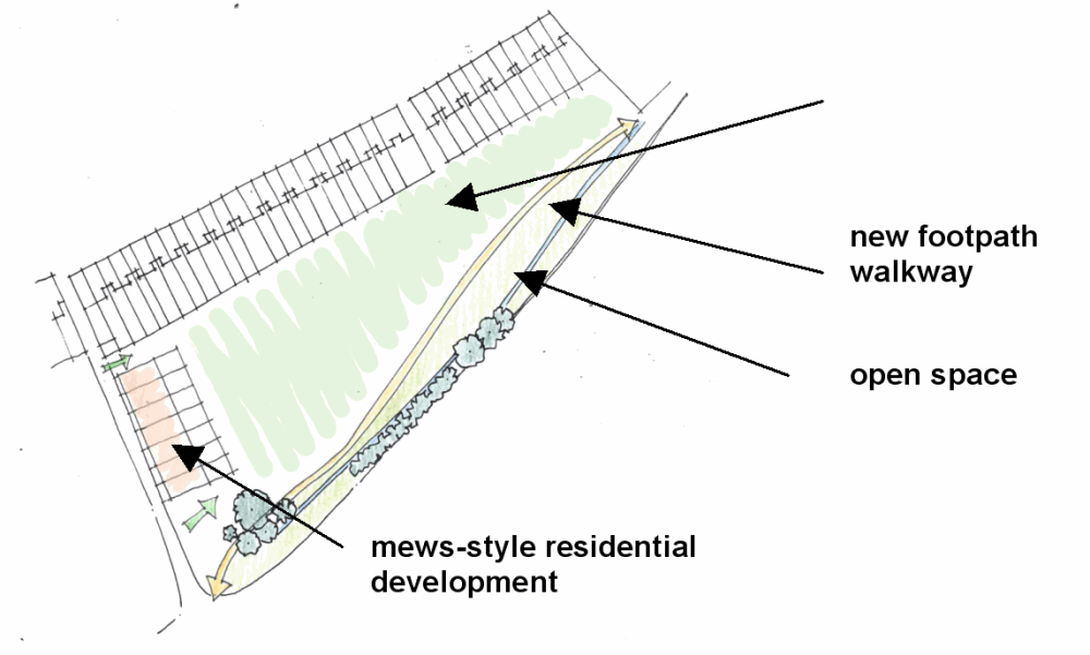
86. Figure 3 provides an indicative spatial plan for the site, which describes this site as broadly having 3 key areas within; a residential core to the northern and western sides, a commercial hub to the south-west, and a riverside strip of mixed-use on the western side.
Figure 3: Site A Illustrative Spatial Plan
Uses
87. Mixed uses which encourage activity and vibrancy should have a strong presence in this area.
88. Development should include commercial uses such as shops, cafes, restaurants and small scale workshops (possibly for craft-type activities) which would draw local residents and tourists alike into the area as well as helping to secure economic activity locally. Open spaces where people can linger and enjoy the facilities and the location should be planned into the development.
| Use | Character | Indicative floorspace/ dwelling numbers |
|---|---|---|
| Retail | Small units (say, 30sqm each) | 120sqm |
| Café/restaurant | 50sqm | |
| Workshops/small B1 units | For artisan/craft businesses and other light industry | 200sqm |
| Live/work units | Dwellings with dedicated space for business | 5 - 10 units |
| Residential | Mix of flats and houses, high density, generally 1 - 3 bed properties, including flats over commercial premises. | 80 |
| Open Space | Incorporation of open spaces within the development as a foil to the built form and as an asset for residents and visitors. Careful consideration should also be given to how the development can meet the requirements it generates for formal play space (Policy CF4). | |
| Public car parking | A dedicated area for public parking could provide short stay parking which existing residents could use by permit. Such a facility could act as a buffer between the development and the existing properties at St Margarets Terrace and South Undercliff. | Up to 50 spaces |
89. The following is a 'rule of thumb' to guide the mix of uses in this area:
10 residential units : 1 live/work : 25sqm B1 : 20sqm retail/A3
Access
90. In line with Principle 3, development on this site should provide for an improved junction with A259(T) sufficient to serve the proposed and existing development at the western end of the area. This is a principal linkage with the historic core of the town and should be designed to reflect its significance, avoiding the trunk road becoming a barrier between the town centre and its waterfront, and to provide an attractive entrance and access into the site and riverside.
91. Fundamental to the scheme on this site is the shifting eastwards of the north/south stretch of the main access route into the site to allow sufficient width for redevelopment on the western edge of the site, incorporating an adequate riverside walk for the public, to facilitate an attractive, direct public riverside access into the site. This should also be linked to the re-siting of the Southern Water pumping station building. Any redevelopment proposals will need to take account of these requirements in spatial planning terms and, as necessary, through financial contributions.
92. To accommodate the anticipated vehicle movements, the service road should be of an adoptable standard with a 6m carriageway, sufficient to allow for on-road cycling and widening on radii to allow for HGV tracking. A single footway along the edge of the road may be sufficient, depending upon the service road's proximity to the riverside walk and to the shared surfaces of the core of the development. The road should be aligned to enable a link to the junction with Shipyard Lane.
93. Links into and through the site should be clear and attractive to use, particularly for those on foot and cyclists. The pedestrian route should be planned to run alongside the river to the maximum extent possible and should allow for sections to be added should further riverside sites become available in the future. Subject to the decision on the future use of the allotment site, contributions from development on this site will also be sought to achieve improved pedestrian and cycle links through the centre of the Rock Channel area towards the Fishing Quay area.
94. The core of this site should be designed for low traffic speeds following 'Home Zone' principles, with pedestrians and cars sharing street surfaces.
Design considerations/Form of development
95. In addition to the guidance given under Principle 5, there are some specific considerations which relate to this site.
96. Development must be sited carefully in relation to the existing residential properties at St Margarets Terrace and South Undercliff in respect of scale, mass and residential amenity.
97. Development running north/south adjacent to the riverside on the western side of the site will need to provide adequate space for an attractive public riverside walk alongside the river here, while buildings facing the river need to present an active frontage.
98. A relatively high density of residential development could be achieved on this site (in the order of 80 dwellings/ha). Residential mews streets should be designed at height-to-width ratio approximating 1:1. Street widths will need to wide enough to allow manoeuvring for the carparking in the ground floor of residential properties.
99. In the commercial area, streets may need to be wider to accommodate different types of vehicle. However, the concept of shared space will still apply here and building arrangement together with choice of surface materials will need to ensure that this is a comfortable environment for pedestrians. Streets should open out into a variety of small squares and spaces for visual interest and to encourage community interaction.
100. Buildings on this site should deploy a contemporary vernacular architectural language and materials.
Area A1
101. Area A1 is a location which offers prominent views over the river and back towards Strand Quay. The site is on a long-term lease. Because of its particular attributes, and subject to land owner interests, it could afford the opportunity of creating a valuable public vantage point in the longer term, possibly associated with a use such as a café or restaurant.
Area A2
102. Area A2 is the base for the Rye Sea Cadets, a maritime/community use particularly compatible with the area objectives. However, were the Sea Cadets ever to wish to relocate to a site with direct riverside access (possibly within Area A or Area C), this site could be suitable for additional residential accommodation in accordance with the development principles above.
Site B - Allotments
Site Assessment
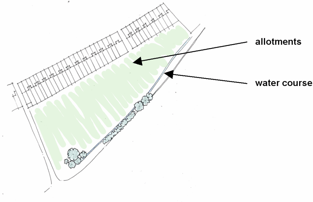
103. The allotments lie in the heart of the Rock Channel area, surrounded by houses on three sides and business uses on the fourth. This part of the area has quite a tranquil feel, in contrast to the busier industrial and commercial activities in the Jempsons/Bournes area (Site A) and in the vicinity of the fishing peninsula (Site C). There is a drainage channel along the southern side of the allotments which discharges into Rock Channel. The public footpath, elevated on a bank alongside the drainage channel, but outside the allotments, contributes to the site's sense of enclosure.
104. In addition to the obvious amenity value to the allotment holders themselves, the allotments constitute a significant area of green space and the open nature of the site benefits, in particular, the aspect from the rear of the South Undercliff properties. There is no public access through the site. Public enjoyment of the area is limited to views of it, in the main from the public footpath.
105. The allotment site is owned by Rother District Council. In the absence of definitive evidence to the contrary, the allotments are presumed to be non-statutory. The South Undercliff site is one of two allotment sites in the town. The other site, adjacent to the Thomas Peacock School, is fully occupied at present. The South Undercliff plots are rented out to private individuals on an annual basis. Council records show that more than 85% of the available allotment plots are currently let (information at June 2007). Some of the vacant plots have never been cultivated. Rye Allotment Society reports that it is aware of people waiting for existing cultivated plots to become available rather than wishing to take on those which have never been used or not been used for a long time.
Options for the Allotment site
106. There are choices about the future of this site. Four options, each representing increasing degrees of change in the area are set out on the following pages, with an assessment of the advantages and disadvantages of each.
107. The four options are;
- Option B1: no change;
- Option B2: creation of footpath link and public space alongside the allotments;
- Option B3: limited residential development along the Shipyard Lane frontage; and
- Option B4: site developed wholly for residential use.
These are represented in diagrammatic form on pages 27 and 28.
Allotment Site Options - Sustainability Appraisal
The appraisal process recorded the health and recreational benefits of retaining the allotments as well as the area's biodiversity potential (option B1). Improved access through the area (option B2) adds to the recreational benefits, whilst acknowledging that this could raise concerns about the risks of additional vandalism etc. Option B3 scores well through the SA process as it provides additional housing (sustainability objective 1) as well as largely supporting the retention of the allotments and improved public access. Option B4 adds to the provision of housing, including affordable housing, although the final sustainability impacts of this option are contingent upon the location and characteristics of alternative allotment site (as yet unidentified). Similarly the impacts of built development (options 3 and 4) on the setting of the Citadel is dependent upon its final form, siting and design.
108. Option B1 maintains the status quo, but does not afford any additional public benefits. Option B2 provides for improved public access with limited disturbance to the current arrangement of allotment plots. Whilst providing for the greatest range of different uses and facilities, Option B3 would see development on the most intensively cultivated part of the allotment site, requiring the significant relocation of plots within the site.
109. At this point, Option B4 does not accord with Local Plan Policies RY3 or CF2 as an alternative site for the allotments has not been identified. This option should not be pursued unless a suitable alternative is found to be available.
110. Option B2 - the creation of a footpath link and public space alongside the allotments - is the Council's preferred option at this stage.
111. All these options will be further explored through the consultation process for this draft brief. A single option will be carried forward into the finalised brief.
Option B1: No Change
The site would continue to be wholly used for allotments.
Pros
- Number and extent of allotments maintained
- Scope for currently unused allotments to be brought into use
Cons
- Limited public enjoyment of the site
- No improved connectivity between Strand Quay and the Fishing Quay area
Option B2: Creation of footpath link and public space alongside allotments. This is the Council's Preferred Option .
A new footpath would be created through the south-eastern side of the site to provide a more attractive connection through the Rock Channel area. The ecological value of the existing watercourse could be enhanced. This option could include the creation of an additional area of public open space.
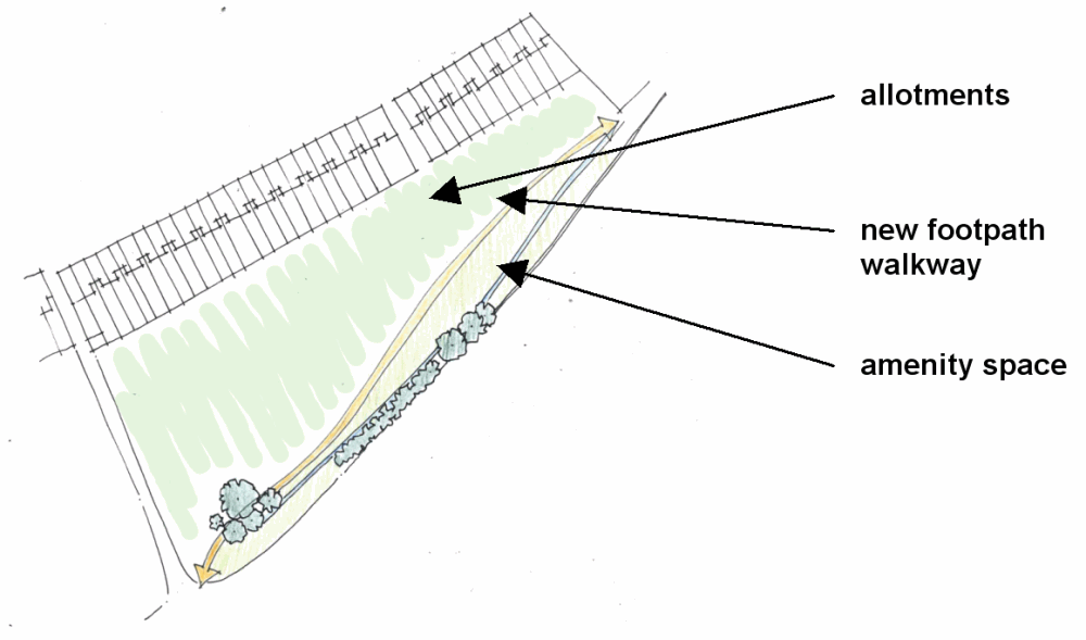
Pros
- Number of allotments in current use is maintained
- Opportunity for environmental enhancements, including creation of an additional area of amenity space
- Increases public access and enjoyment of the area
- Establishes clear, attractive linking route from Strand Quay to Fishing Quay area
Cons
- Steep bank/flood wall to be negotiated at the eastern end of the site. Steps may be needed.
- Possible need to relocate a limited number of allotment plots within the site
- Fear of vandalism/litter resulting from increased public use of the area
Option B3: limited residential development along the Shipyard Lane frontage.
A new footpath would be created through the south-eastern side of the site to provide a more attractive connection through the Rock Channel area. The ecological value of the existing watercourse could be enhanced. This option could include the creation of an additional area of public open space.
Pros
- Additional residential development located close to town facilities
- Existing allotment facility largely retained
- Opportunity for environmental enhancements, including creation of an additional area of public open space
- Increases public access and enjoyment of the area
- Establishes clear, attractive linking route from Strand Quay to Fishing Quay area
Cons
- Residential development on a greenfield site
- Some disruption due to relocation of a limited number of existing allotments
- Steep bank/flood wall to be negotiated at the eastern end of the site. Steps may be needed
- Fear of vandalism/litter resulting from increased public use of the area
Option B4: site developed wholly for residential use.

Pros
- Additional residential development, including affordable housing, located close to town facilities
- Establishes clear, attractive linking route from Strand Quay to Fishing Quay area
Cons
- Residential development on a greenfield site
- Existing allotment facility not retained and alternative site not identified, contrary to Policies RY3 and CF2
- Significant change to the visual and environmental character of the area including change to the aspect of South Undercliff properties
- Steep bank/flood wall to be negotiated at the eastern end of the site. Steps may be needed
Site C - fishing peninsula area
Site assessment
112. The area of this site, identified on Plan D, is approximately 1 ha.
113. The site is largely in commercial use. It is dominated by large scale industrial buildings used for fish processing and vehicle recovery amongst other things, giving it a gritty, industrial character. These buildings are generally in relatively poor condition and contribute little to the setting of the town beyond. Situated between these industrial buildings, and somewhat dominated by them, is the single storey Grade 2 listed Ferry Cottage which is excluded from the opportunity area.
114. The buildings benefit from the protection of the recently improved Rye Tidal Walls. Beyond the tidal walls, to the east, there is an extensive open area used for dry boat storage and repair as well as a number of moorings. This riverside fringe area is an essential part of the character of the setting of Rye, acting as the interface between the developed and reclaimed town and the levels beyond to the east. This site offers the rare opportunity to enjoy panoramic views both over the surrounding countryside and back towards the Citadel.
115. The site also enjoys an immediate relationship in terms of setting, and potential uses, with the large area of green open space known as The Salts which is a valuable leisure resource for the town and with the recently refurbished Fishing Quay to the north.
116. The site is in a single ownership.
Specific Development Considerations
Overall Approach
117. Redevelopment in this area should capitalise the benefits of the location, namely:
- the proximity of The Salts, the Fishing Quay and the Citadel;
- the extent of river frontage; and
- the connection, in both visual and character terms, with the Levels.
118. Further, redevelopment should exploit the potential for:
- a better link between Strand Quay and the Fishing Quay; and
- additional maritime-related uses.
119. Fig 4 provides an indicative spatial plan for the site, which describes this site as broadly having an important accessible 'fringe' on its eastern edge with café activity, with residential to the core, and commercial/leisure uses to the south, with limited residential over.
Figure 4: Site C Illustrative Spatial Plan
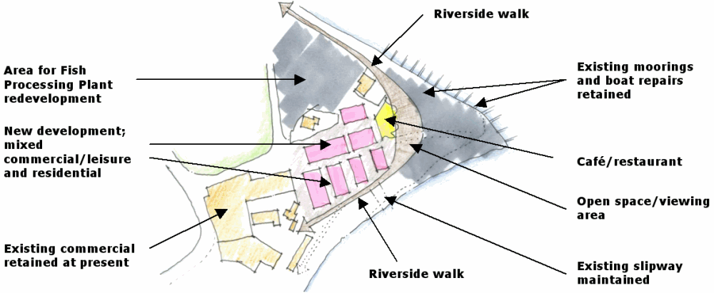
Uses
120. A mix of uses here should help to maintain a commercial and maritime character as well as helping to draw people into the peninsula area.
121. Seaspace and the Rye Partnership have previously identified a desire to rearrange the accommodation at the Fish Processing Plant on the site, either by way of a new building or by remodelling the existing structure.
122. Existing maritime-related uses such as boat storage, moorings and repairs should be retained, and preferably enhanced, as part of any redevelopment proposals in this area. Such uses, supported by an element of retail and restaurant/café uses as well as residential, should be planned to draw people and activity into the area. The potential of this site, with its neighbouring uses, to establish an area with a distinct character and a concentrated hub of maritime-related activity is significant.
123. Redevelopment proposals should also provide for the creation of an area of public open space with riverside walk at the eastern extent of the site, beyond the tidal walls, to exploit the expansive views over the Levels and, in the opposite direction, of the Citadel itself.
| Use | Character | Indicative floorspace/ dwelling numbers |
|---|---|---|
| Café/restaurant |
Important as 'attractor'. Could be associated with the fishing quay/ processing activities to the north of the site |
50sqm |
| Retail | Small units (say, 30sqm each) | 60sqm |
| Fish processing | tbc | |
| Residential | Extend small-scale (two/three storey) intimate character of existing dwellings on site. Mix of flats and houses, high density, generally 1 - 3 bed properties | 35 |
| Live/work units | Dwellings with dedicated space for business | 2 |
| Moorings | Maintain existing with potential to add/enhance | 15 currently |
| Boat storage | Maintain | |
| Open space & Riverside walk | Broadwalk-style route alongside the river connecting through the site, also linking to a hard-landscaped area of public open space enabling 360o views. |
Access
124. The order of development set out above should not increase vehicle movements through the Rock Channel-A259(T) junction above existing levels and as such should not require the relocation of the junction.
125. Service roads should be of an adoptable standard with a 6m carriageway, sufficient to allow for on-road cycling and widening on radii to allow for HGV tracking as necessary.
126. Redevelopment proposals should provide for improved pedestrian circulation within the site, including the riverside walk which should generally follow the line of the recently constructed tidal walls, whilst taking the opportunity to open-up to a larger space at the point of the peninsular itself, from which both the wider countryside and the immediate commercial maritime activity of moorings and boat repair can be appreciated.
127. Clear pedestrian links should also be established towards the Citadel, the Salts and the Fishing Quay. The achievement of a cycle link between the site and National Cycle Route 2 at Monkbretton Bridge making use of the footpath that runs between the Fishing Quay and the Salts should also be an objective of redevelopment proposals.
128. Subject to the decision on the future use of the allotment site, contributions from development on this site will also be sought to achieve improved pedestrian and cycle links through the centre of the Rock Channel area towards St Margarets Terrace.
Design considerations/Form of development
129. In addition to the guidance given under Principle 5, there are some specific considerations which relate to this site.
130. Firstly, particular careful consideration should be given to the siting of new development relative to the listed Ferry Cottage and its setting.
131. It is also essential that the raw, open character and outlook of the opportunity area is maintained in any development proposals within this site, whilst ensuring that such development capitalises on the opportunities for enhancing public views out to the countryside beyond here.
132. The public open space should be the only part of the development which falls outside the flood-defended area.
133. In long views, the site offers low visual relief to the steepness of the Citadel, topped by the Church, and built forms must be of an appropriate height and fragmentation so as to demonstrably not compromise this important legibility. Buildings should be predominantly two-storey, with elements of three storey for articulation. The fragmented built forms will also help create visual interest and permeability through site.
134. Any development must respond positively in siting, scale and mass to existing residential properties on or adjacent to the site, and take design cues from the attractive jumbled, intimate scale and layout of these buildings
135. Buildings on this site should deploy a contemporary vernacular architectural language and materials.
Area C1
136. The industrial buildings that hug the bend in the A259(T) at the northern end of the area compromise the visual quality of this part of Rye by virtue of their scale, condition and utilitarian construction. The buildings are prominent in views out from the Gun Garden and act as a barrier to access deeper into the Rock Channel area.
137. The appraisal of the area identifies how this area is potentially an important gateway into the northern part of the Rock Channel area. Whilst acknowledging the Highways Agency advice about the capacity of the existing Rock Channel - A295(T) junction, redevelopment here in the longer term could help to open the area up, enhance the setting of the Citadel and encourage more activity into the fishing peninsula area, should landowner intentions allow.
Area C2
138. To the south of the fishing peninsula site, fronting the river there are a number of single storey workshops and small scale industrial buildings from which maritime related businesses in the main operate. The activity of the businesses and the scale of the buildings themselves contribute to the character of this part of the area and, in particular, its sense of intimacy.
139. Improvements to the fabric and condition of these structures would be a benefit although, in making any such changes, care should be taken not to erode the essential character of the area.