Proposed Submission Core Strategy
18. TRANSPORT AND ACCESSIBILITY
Scope and Issues
18.1 A sustainable, functional and viable integrated transport system that serves the residents of Rother is crucial to support the economic, social and environmental aspirations of the residents of Rother, as represented in the East Sussex Sustainable Community Strategy: Pride of Place.
(1) 18.2 The transport strategy is based on deliverable and realistic improvements to the existing transport network, and will be co-ordinated with regeneration efforts to stimulate the economy of Rother’s main settlements and surrounding rural hinterlands.
18.3 Rother is predominantly rural with three main settlements: Bexhill, Battle and Rye, although nearby Hastings is the centre of the ‘travel to work area’ for much of Rother district and there are significant movements between the districts.
18.4 Figure x shows the County’s main settlements with main road and rail links. In 2001 it was recorded that there are significant journey to work movements out of East Sussex64 and Rother 65 creating pressure on the district’s transport network.
Figure 18: Map showing Main Settlements with Rail and Road Links
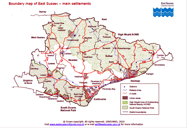
Source: East Sussex in Figures 2010
18.5 Population and economic growth will put further strain on transport capacity, and hence on achieving the development potential and desired regeneration of the area. The linkages connecting Rother with the main settlements in East Sussex and the rest of the South East currently offer unreliable and sometimes protracted journey times and are widely regarded as significant impediments to its future regeneration and growth of local businesses66. There is also a high level of serious traffic accidents on roads in Rother.
18.6 The challenge will be to take a co-ordinated approach to transport, increasing capacity where it is possible, and managing constraints on the main movement arteries across the district.
18.7 Hastings and Bexhill need integrated strategies for sustainable regeneration to fulfil their joint role as a significant centre for commercial, industrial and economic activity, as discussed in Section 7. However, the Five Point Plan 67 recognises that unlocking the area’s full development potential as a business location will not be properly realised without investment in the transport infrastructure.
18.8 Critical additional capacity to alleviate congestion along the A259 Trunk Road corridor can be achieved through the construction of the proposed Link Road between Bexhill and Hastings.
18.9 The Link Road was granted planning permission in 2009 and has been the subject of a public inquiry into Compulsory Purchase Orders. This scheme received provisional approval, but in June 2010, the Secretary of State announced a suspension of major transport schemes other than those under construction. In October 2010, the Link Road scheme was been placed in a ‘Development Pool’ of schemes, all bidding for a share of a £600m fund. Hence, while it has been demonstrated to be vital to enable local regeneration and growth, it is still uncertain. A final decision will be made at the end of 2011.
18.10 Transport is also a significant issue for some communities in rural Rother. An inadequate public transport system makes it difficult for some communities to reach jobs or shops, or to meet appointments or to visit friends. People on lower incomes are likely to be reliant on public transport to access jobs and services.
18.11 The busy market towns of Battle and Rye suffer from congestion during summer months, detracting from the very qualities that make the area attractive to visitors. Many villages and rural areas suffer from heavy, fast-moving traffic volumes on unsuitable roads, making it dangerous to walk or cycle.
18.12 At a countywide level the transport policy framework is currently provided by Local Transport Plan 368 (LTP3). LTP3 is a statutory document and will guide transport provision in East Sussex up to 2026. At a local level, there are the Local Area Transport Strategies (LATS) for Battle and for Rye.
Objectives
18.13 The Local Development Framework can contribute towards re-balancing of the transport system through the preparation and implementation of policies that facilitate transport investment, provide for development in accessible locations, and promote sustainable transport choices.
18.14 The Strategic Objective for transport in Rother, as set out in chapter 6, is:
To provide a higher level of access to jobs and services for all ages in both urban and rural areas, and improve connectivity with the rest of the region.’
(1) 18.15 This can be refined in terms of seeking to:
Strategic Accessibility
18.16 Improving transport networks to the wider South East is a key component of East Sussex Community Strategy: Pride of Place.
18.17 Two transport corridors cross the district, one being south – north, the other east –west: the former comprises the A21 trunk road and the Hastings to Charing Cross rail corridor. The East to West corridor comprises of the East Coastway rail line and the A27/A259 trunk road.
(1) 18.18 Rail infrastructure is co-ordinated through Network Rail. Rother falls between two rail utilisation strategies (RUSs): Kent RUS and Sussex RUS respectively. It is the responsibility of the RUSs to identify gaps in the service and recommend a range of options to bridge these gaps, including train lengthening and additional services to address capacity and line-speed improvements at key points to improve capability and shorten journey times. However, desirable schemes to improve rail links to Rother and Hastings are not currently programmed.
18.19 In relation to road transport, key delivery agencies include the Highways Agency, East Sussex County Council and private bus operators. A number of significant infrastructure schemes were at various stages of development, but these have been dramatically knocked back.
18.20 Following the Comprehensive Spending Review, the A21 Baldslow improvement, and Flimwell to Robertsbridge upgrade have been cancelled. While work to implement the A21 Tonbridge to Pembury Bypass is due to progress, it is subject to the outcome of statutory processes and funding. As stated earlier, the Bexhill to Hastings Link Road is still waiting a final decision.
18.21 The economic downturn has brought into question the prospect of significant investment in infrastructure in the immediate future. To realise the objectives of the transport strategy, the relevant agencies, stakeholders and communities will be required to work together to make best use of the existing capacity through more efficient use of the network and smaller schemes to increase capacity, at the same time as continuing to promote investment along key arteries.
18.22 Of particular significance is the A21 corridor, where the Council will continue to lobby for improvements. Increasing capacity of the connection between The Ridge and the A21 at Baldslow is a particular priority, and the Council will work with the respective highway authorities and Hastings Borough Council to investigate the potential for alternative means of increasing highway capacity in the area.
18.23 As the Local Transport Authority, East Sussex County Council has a statutory duty to produce a Local Transport Plan. Following consultation at the end of 2010 and amendments made to the document the final version of LTP3 is available from May 2011. LTP3 sets out the strategy for delivering both the County Council’s and Government’s transport objectives. LTP3 will continue to pursue and lobby for strategic road, rail and public transport improvements to help deliver sustainable economic growth. It is acknowledged some of the schemes are long term aspirations and the means of funding and delivery is uncertain, such schemes however may be realised due to future changes in national policy or funding becomes available during the lifetime of LTP3.
(9) Policy TR1: Management and Investment in Strategic Accessibility
Support will be given to the improvement of strategic infrastructure that will strengthen the role of Rother, and especially Bexhill, as an area of economic activity and investment opportunity. Priority will be to improve connectivity along key transport corridors; enable regeneration and reduce entrenched economic and social disparities. This will include:
-
Support for early implementation of the Bexhill to Hastings Link Road and associated bus and cycle improvements;
-
Working with agencies and stakeholders to deliver effective management of strategic transport corridors;
-
Investment into providing transport choice; and
-
Working with agencies to upgrade the capacity and capability of the East Coastway and Hastings to London rail corridors (including investigating potential for a new station to the west of Hastings and Glyne Gap, Bexhill).
Integrated Transport
18.24 In 2008, there were 428 road casualties69 on Rother’s road network, approximately 20% of the County’s total. In terms of road safety, indicators demonstrate Rother is significantly worse than the regional and national average.
18.25 In 2008/09, 33% of respondents in Rother cited public transport as a Priority for Improvement in the Local Area70. Access to rural transport and road safety have also been identified as key to improving the quality of life for residents of Rother71. However there appears to be a poor perception of public transport in Rother; a car is seen as a “necessity” for the majority of people 72.
18.26 Access to facilities and services relates not only to where they are located, but also to the provision of transport to access those services. In 2001, 21%73 of households in Rother did not have a car. Such households can find it difficult to access jobs, services and other facilities. This can exacerbate rural poverty and social disadvantage. Studies have demonstrated an insufficient public transport network can impact disproportionally on deprived communities
18.27 In 2010, a survey of businesses across East Sussex found that the most common transport concerns for businesses are accessibility for customers/clients visiting a business and staff travelling to work.
18.28 The Hastings and Rother Accessibility Assessment completed by the County Council in 2007 found that in rural parts of the district, households without a car found access to services quite or very difficult.
18.29 Recognising that within the context of a rural area where, for many trips, there are limited alternatives to the car, attention may be focussed on altering the perception that a car is vital for most if not all journeys, and on reducing barriers to public transport. This can be achieved through promotion of walking and cycling for local trips, particularly within towns and villages, traffic management schemes and investment to reduce the impact of traffic on the rural and urban environment, and by promoting public transport and sustainable development.
18.30 The rebalancing of the transport system to walking, cycling and public transport can deliver better health and quality of life for local residents and make more attractive, competitive places with less congestion and better air quality. Locating development in accessible locations, and good urban design, will encourage people to make short journeys on foot or by bike; for example, by employing green infrastructure to link homes, schools, employment and local services.
18.31 Central to a strong integrated transport system is maximising ease of access and transfer between different modes as well as the quality of the amenity experience. The public realm can appear fragmented and cluttered with excessive street ‘furniture’, making for an unpleasant experience for people travelling between spaces. Improving the quality public realm74 is seen as part of a wider transport and townscape agenda which encourages walking and cycling.
18.32 Since 1991, there has been an increase in the number of commuters75 across East Sussex and a high proportion of commuting journeys is by car. In Rother 6% of commuters use rail to travel to work 76. It is important to tackle the high proportion of commuting journeys by car by making improvements to public transport, including rail travel. Across the rail industry, passenger numbers has gradually increased over the last decade; however in the last two years, this has deceased slightly and can be attributed to the economic downturn77.
18.33 Encouraging commuters in Rother to switch to rail will result in additional pressure on rail infrastructure. Capacity at some of the district’s station car parks is at or near capacity. Many commuters choose to travel to the train station by car and park in the station car park or on residential streets nearby. It is a significant local issue78 because of the high levels of congestion generated around peak travel times and road safety concerns.
18.34 Passenger Focus, the independent passenger watchdog, commissioned a survey amongst passengers (South East - 2010) to identify elements of the service they would like to see improved. Adequate car parking facilities was identified as one of the issues where passenger’s expectations were not being met. The Kent and Sussex Route Utilisation Strategies respectively, have recommended any proposal to expand parking facilities at stations should be given detailed consideration at local level.
18.35 At a local level, there may be scope to increase parking at railway stations. However in some cases, the expansion of car parking facilities may not be physically possible or economically viable. Priority will be to encourage passengers to access stations by bus or cycle, with suitable provision.
(7) Policy TR2: Integrated Transport
Improvements in the provision and use sustainable transport will be achieved through:
-
maximising the best and most effective use of the existing transport network and facilitating enhancements with priority given to improving bus, community transport and rail network;
-
the promotion of public transport patronage and associated infrastructure;
-
supporting the provision of a high quality cycle network to encourage a modal shift away from the car;
-
improvements to the pedestrian environment and wider public realm to encourage integration between different modes of transport, employment areas and settlement centres;
-
promotion of road safety through education and design; and
-
safeguarding sites and routes with the potential to contribute towards the provision of an efficient and sustainable public transport network.
Access and New Development
18.36 Government transport guidance seeks to reduce the need to travel especially by car, with the aim of reducing congestion, improving the environment, increasing social inclusion and improving health. As part of planning applications, applicants are expected to assess the transport impact of their development proposals and mitigate the impact of any material increase in traffic on the district’s roads.
18.37 The Spatial Strategy indicates new development will be directed mainly to the district's towns and villages where there is a good range of services, facilities and jobs. This will contribute to reducing the need to travel and journey lengths. It will also help achieve a more sustainable form of development and support the viability of public transport.
18.38 A Travel Plan is required for large development proposals in accordance with the DfT Guidance for Transport Assessments (DCLG/DfT, March 2007). This guidance also recommends the use of Travel Plan Statements (TPSs) for smaller developments where a full Travel Plan would be inappropriate. These seek to encourage sustainable travel choices and use of measures commensurate with the scale of the development.
18.39 Where existing transport infrastructure is inadequate to meet the needs of new development, conditions or planning obligations will be used to ensure that proposals are made acceptable through securing the provision of necessary improvements.
18.40 The design and layout of road and street networks, in accordance with DfT’s ‘Manual for Streets’, is considered in Chapter 16 – Environment, under ‘Design Quality’.
(8) Policy TR3: Access and New Development
New development should minimise the need to travel and support good access to employment, services and communities facilities, as well as ensure adequate, safe access arrangements. Development will be permitted where mitigation against transport impacts whichmay arise from that development or cumulativelywith other proposals is provided. This will be achieved through the submission of a transport assessment, transport statement or travel plan 79, and where it is appropriate through:
-
ensuring that new developments in their design and layout prioritise the needs of pedestrians, cyclists and minimise the distance to local public transport nodes;
-
working with the relevant agencies to seek funding for contributions for improvements to local infrastructure needed to facilitate highway capacity and safety and/or public transport accessibility and capacity, where this is necessary to serve the new development; and
-
Provision of electric vehicles charging infrastructure
Car Parking
18.41 Given the rural nature of the district, it is likely that the car will continue to be the main form of transport for some communities in Rother. It is important that sufficient parking provision is provided at all new developments. The 2001 Census found that over 79% of households in Rother have access to a car. Given the limitation to existing public transport infrastructure, a car is seen as a necessity in many rural parts of the district.
18.42 In January 2011, the Government announced changes to Planning Policy Guidance 13: Transport (PPG13) in relation to parking standards. The onus is now on local authorities to determine standards, taking account of local circumstances. The previous requirement to express “maximum” parking standards for new residential development has been deleted.
18.43 For development management purposes, the Council adopted, on a interim basis, the car parking standards advocated by East Sussex County Council‘s (ESCC) supplementary planning guidance (SPG) on parking standards, with the following variations:
- Lower standards should not be applied to either smaller dwellings or affordable housing;
- The lower policy standards in central areas is not rigidly applied, with the merits of each application reviewed on a case by case basis.
- This approach can be seen as consistent with current Government policy. It is therefore envisaged that these continue to be applied, and form the basis of a future Supplementary Planning Document.
(2) Policy TR4: Car Parking
Planning permission will be granted for development where the provision for parking accords with the following principles which will be elaborated upon in the form of Supplementary Planning Document. Proposed development shall:
-
meet the residual needs of the development for off-street parking having taking into consideration localised circumstances and having full regard to the potential for access by means other than the car, and to any safety, congestion or amenity impacts of a reliance on parking off-site whether on-street or off-street;
-
provide for reduced parking provision where a high level of accessibility to jobs, services and facilities exists, or will be provided as a result of the development, including any offsite measures;
-
ensure that the approved parking provision is retained for the future where that would be necessary to prevent harm to the safety or free-flow of the highway;
-
include a number of parking spaces designed and signed for disabled people; and
-
provide for commuted payments towards providing and/or managing off-site parking, including on-street parking, where this is justified to meet the needs of the development.
64 Commuting flows in 2001 showed there was a net flow going out of East Sussex for travel to work purposes (-32,279). Source: ESIF 2010 65 Commuting flows in 2001 showed there was a net flow going out of Rother for travel to work purposes (-5824). Source: ESIF 2010 66 Transport issues can be seen as contributing to the barriers to growth that some East Sussex businesses face. 19% identify journey times as an important constraint on the growth of their business over the next year, with 70% noting that this issue is likely to have “some effect” on their business. Source: Section 5. The East Sussex Economic Study 2008 - 2009, Nov 2008 67 The Five Point Plan for the regeneration of Hastings and Bexhill (which, together, are home to nearly 130,000 residents) was developed by a special task force (Seaspace) and approved by Government in March 2002. In aiming to provide the catalyst for lasting economic, social and physical regeneration, it presents a ten-year strategy around five main themes: urban renaissance, business and enterprise development, excellence in education, broadband connectivity and transport 68 Local Transport Plan 3 (draft consultation autumn 2010) 69 East Sussex in Figures - Recorded Road Casualties between 1994-2008 by district 70 East Sussex in Figures – Priorities for Improvements in the Local Area - Place Survey 2008/09 71 East Sussex Pride of Place A Sustainable Community Strategy for East Sussex 2008 – 2026 Rother Section 72 Hastings and Rother Accessibility Assessment, June 2007 73 East Sussex In figures – Car Ownership in East Sussex in 1991 and 2001 by district 74 Manual for Streets 2007 and Street for All: South East 2005 75 Since 1991, East Sussex has seen a significant increase in the number of people commuting to work. The number of people travelling into the county to work increased by around 4,500 to just under 16,400 by 2001. Focus for East Sussex 2010 Annual Monitor Report 76 Source: 2001 Census - Table 3.1 Local Transport Plan 2 East Sussex. Rail travel patronage in Rother is above the County average. 77 National Rail Trends 2009-2010 Yearbook 78 Battle LATS 79 Threshold criteria definition contained in the “Guidance on Travel Plans for New Development” East Sussex County Council, Sept 2008