Proposed Submission Core Strategy
17. ENVIRONMENT
Scope and Issues
17.1 The Rother district contains a blend of some of the most beautiful countryside and coastline in South East England. The landscape character of the district varies from low-lying flat marshland to the east, with expansive fields divided by occasional hedgerows, through the ancient mosaic landscape of the High Weald, with gently undulating pasture punctuated with species-rich hedgerows, copses and ancient woodland, to the more steeply contoured land around the sandstone ridge-top.
17.2 The district also has a rich architectural legacy, including as it does the historic market towns of Battle and Rye, the Victorian and Edwardian seaside town of Bexhill-on-Sea, a host of picturesque villages, listed buildings, including many isolated farmsteads dispersed throughout the High Weald, together with modernist buildings from the 1930s and 1960s, and a number of strong examples of contemporary architecture.
17.3 The importance of the natural and built environment in Rother district is evidenced by the extent of the district (some 82%) which is designated as an Area of Outstanding Natural Beauty (AONB), a Conservation Area, or an Archaeologically Sensitive Area and by the key role which the district’s architectural heritage and natural environment play in the tourist industry.
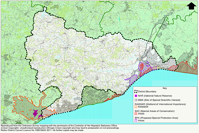
17.4 Meanwhile, the district’s countryside also includes areas both of international and national, as well as local, importance in terms of their ecological value. The international designations (variously Special Protection Areas, Special Areas of Conservation, and Ramsar Site/candidate Ramsar site) apply to large parts of the low-lying areas of the Pevensey Levels and Walland Marshes.
17.5 The environmental qualities that make the district so special are under considerable pressure from a number of factors. These include development, flooding, pollution, the challenges of climate change, and a changing agricultural economy. The custodianship of such a valued natural and built district requires a high level of environmental stewardship, alongside the development of robust strategies, to ensure that such positive characteristics are preserved and successfully managed for future generations.
Objectives
17.7 Chapter 6 presents the following Strategic Objective with regard to the Environment:
‘To maintain the high quality, and improve the long term stewardship, of the natural and built environment, with full regard to potential future consequences of climate change’
(1) 17.8 The following objectives further amplify the Strategic Objective:
(2) Environment Objectives:
|
17.9 The main policy areas relative to these objectives are regarded as being:
- Landscape Stewardship
- Design Quality and the Built Environment
- Biodiversity & Green Space
- Flood Risk
Landscape Stewardship
17.10 Rother’s landscape has great environmental and economic importance, as well as contributing to our sense of identity and well-being and providing inspiration. Though the landscape character is based in the distinct local geography and topography of the area, the landscape also charts the continuing history of the relationship between people and place.
17.11 Most of the Rother district falls into two of the National Character Areas defined by Natural England (formerly Joint Character Areas), that is NCA 122 High Weald and NCA 123 Romney Marshes, though a small amount of the district also falls within NCA 124 Pevensey Levels, and Natural Engalnd have provided detailed countryside and landscape character statements for each of these areas, identifying key characteristics.
17.12 Meanwhile the ESCC Landscape Assessment progresses this analysis at a more detailed level, seeking to improve understanding of our local landscape. This is in order to better manage change and to ensure that change and development do not undermine what is distinctive about landscape, as well as informing ways of enhancing character.
17.13 The Assessment identifies a number of areas of distinct landscape character within the Rother district, including:
- The High Weald
- The Upper and Lower Rother Valley
- The Brede Valley
- The Darwell Valley & Combe Valley Basin
- The Rye and Winchelsea Levels
and recommends specific Landscape Action Priorities tailored to the special characteristics and pressures facing each area. The document also identifies relatively remote areas within the district where current human impact is relatively limited, including the Upper Rother and Dudwell valleys, the Dallington-Ashburnham area and the Walland Marsh. Such areas contribute significantly to quality of life and local character.
17.14 The High Weald AONB Management Plan 2009 addresses the primary purpose of an Area of Outstanding Natural Beauty - the conservation and enhancement of the special features that represent its natural beauty. In doing so it sets out key guidelines for the management of the landscape by defining “Natural Beauty” in terms of its key features. The principal components are; Geology and Water Systems, Settlement, Woodland, Routeways and Field and Heath, and their combined contribution to forming the cultural landscape of the High Weald.
17.15 The Rother Ancient Woodland Inventory 2010 identifies that 15.5% of Rother is ancient woodland, having been in continuous existence since 1600. This is the highest percentage of any district in the South East and provides a rich environment for a broad range of flora and fauna.
17.16 Meanwhile, English Heritage have produced a range of best practice guidance on Historic Landscape Characterisation and understanding the archaeology of landscapes, to help inform future management.
Landscape Pressures
17.17 A particular challenge for new development in sensitive environments is maintaining the visual character of settlements in the landscape and in particular settlement edges. New development also brings the threat of suburbanisation of landscape character, with roads, light pollution, gentrification of buildings and loss of tranquillity.
(1) 17.18 Further pressures on landscape character come from recreational land-uses, including tourism and leisure. It should be recognised that such uses can create awareness of landscape management issues and provide investment to implement improvements, as well as being crucial for the wider rural economy.
17.19 Landscape character is also under pressure from changing agricultural practices, and from declining management of landscape features, including coppice woodlands, small ponds and meadows. This is addressed specifically in Chapter 11: Countryside.
(6) Policy EN1: Landscape Stewardship
Management of the high quality historic, built and natural landscape character is to be achieved by ensuring the protection, and wherever possible enhancement, of the district’s nationally designated and locally distinctive landscapes and landscape features; including
-
The distinctive identified landscape character, ecological features and settlement pattern of the High Weald Area of Outstanding Natural Beauty;
-
The distinctive low-lying levels to the east of the district with particular regard to the landscape setting of Rye and Winchelsea;
-
Nationally designated historic sites including listed Parks and Gardens, Scheduled Ancient Monuments and the Registered Historic Battlefield at Battle;
-
The undeveloped coast;
-
Open landscape between clearly defined settlements, including the visual character of settlements, settlement edges and their rural fringes;
-
Ancient woodlands;
-
Tranquil and remote areas, including the dark night sky;
-
Other key landscape features across the district, including native hedgerows, copses, field patterns, ancient routeways, ditches and barrows, and ponds and water courses
Design Quality and the Built Environment
17.20 Rother district has a valuable and extensive historic building stock. Towns and villages display particular relationships with their landscape surroundings, while the pattern, form, appearance and use of individual buildings and the materials of their construction are peculiar to both the regional and local location and contribute to the unique sense of place, cultural identity and local distinctiveness of both the district as a whole and of the each settlement.
17.21 The landscape setting of individual towns and villages varies from the linear form most usually associated with ridge-top development, to the less common valley setting associated with river crossings. Particularly distinct settlements are the nucleated hill-top setting of the ancient town of Rye, and the formalised medieval grid plan of Winchelsea. Historic farmsteads with farm building typologies representing locally distinctive historic agricultural practices, are prolific within the undulating pastureland.
17.22 Meanwhile the architectural profile of the district has grown with a number of recent innovative and contemporary developments, including individual buildings, small-scale sites and public realm projects.
17.23 New development in the district can simultaneously pose a potential threat and an opportunity: a potential threat to the integrity, character and appearance of the historic built environment and its landscape context; and an opportunity to create new places and buildings with their own positive architectural character and place-making qualities that respect their local context and setting, or which take opportunities to improve areas of poor visual character.
Historic Environment
17.24 The historic built environment within the Rother district is highly valued amongst the community. It benefits from a high level of statutory protection, including as it does over 2000 Listed Buildings, 10 Conservation Areas, a number of Scheduled Ancient Monuments and the ‘Historic Battlefield’ at Battle. However, there remain many other non-designated buildings and archaeological assets which contribute positively to the physical, historic and socio-cultural character of the district, and which warrant retention and interpretation. Such features of the historic environment, both designated and non-designated, are referred to as ‘Heritage Assets’ in central government guidance Planning Policy Statement 5: Planning & the Historic Environment.
17.25 The management of the historic environment requires understanding of its local and regional significance and character, and consideration of the impact of new development, including impact on historic fabric and impact on wider setting, on this significance and character.
17.26 Particularly locally distinctive building typologies and features include long sweeping catslide roofs, oasthouses, timber-framed barns and other agricultural buildings associated with local historic farming practices, and medieval Wealden Hall Houses, found either as rural farmhouses, or incorporated into the fabric of villages and towns, and often much disguised through later alterations. Archaeological survey and investigation is invaluable in such instances to understand the history and significance of these timber-framed buildings.
17.27 Historic buildings in the district generally deploy a limited palette of materials associated with the local High Weald geology, namely timber-framing, clay tiles (for roofs and wall hanging) and brickwork. In specific pockets to the east of the district, white-painted weatherboarding is prolific, and to the west of the district are distinctive groups of buildings constructed from the local Brightling sandstone.
17.28 Meanwhile, the coastal resort town of Bexhill-on-Sea has a rich heritage of late Victorian and Edwardian villa architecture, imposing in scale and ornate in detailing, which plays an important role in defining the local character and street scene.
(3) Policy EN2: Stewardship of the Historic Built Environment
Development affecting the historic built environment, including that both statutorily protected and the non-statutorily protected, will be required to:
-
reinforce the special character of the district’s historic settlements, including villages, towns and suburbs, through siting, scale, form and design;
-
take opportunities to improve areas of poor visual character or with poor townscape qualities;
-
preserve, and ensure clear legibility of, locally distinctive vernacular building forms and their settings, features, fabric and materials, including forms specific to historic building typologies;
-
make reference to the character analysis in Conservation Area Appraisals, where relevant;
-
reflect current best practice guidance produced by English Heritage and HELM 59;
-
ensure appropriate archaeological research and investigation of both above and below-ground archaeology, and retention where required.
Design Quality
17.29 It is not just in historically sensitive areas that design is important; National planning policy guidance in PPS1 and PPS3 clearly indicates that design quality is a crucial planning consideration on all sites. High quality architecture and design has the power to inspire and enrich lives, through the creation of visually attractive, safe, accessible and characterful places that people enjoy living in and visiting.
17.30 Ensuring that design quality is a fundamental consideration in the planning process and to ensure constantly improving design standards, calls for development proposals to demonstrate standards of design against recognised criteria. This will also improve clarity of design assessment.
17.31 To this end, the Council has identified ‘Key Design Principles’ below, which should be seen as a critical starting point for any successful design project. The principles, which it is intended will be further developed through a Supplementary Planning Document, have been based on current best practice guidance, including the design objectives listed in By Design – Urban Design in the Planning System, and the ‘Building for Life’ Standard developed by CABE and HBF, and in Manual for Streets (DfT) and Streets For All: South East (EH & DfT).
17.32 The Council’s Key Design Principles are identified as being:
- Character (Identity & Place-Making) & Legibility
- Continuity & Enclosure
- Quality of Public Realm & Ease of Movement
- Diversity
- Landscape Setting of Buildings and Settlements
- Design in Context
- Building Appearance & Architectural Quality
- Sustainable Design
17.33 The principles are elaborated upon in Appendix 4. They can be met through a variety of aspects of development form including site layout, disposition of development, landscape structure, scale, height, massing, and careful consideration of building appearance in terms of details and materials. Additionally, a high quality design will rely on the skill of the designer to interpret site context and their design brief to create a robust architectural solution which contributes positively to the character of the site and surroundings.
17.34 The principles relate to development of all scales, whether a housing development of many units, or a modest extension to an individual building, though clearly some are more relevant in certain cases.
(3) Policy EN3: Design Quality
New development will be required to be of high design quality by:
-
contributing positively to the character of the site and surroundings, including taking opportunities to improve areas of poor visual character or with poor townscape qualities, and
-
demonstrating robust design solutions tested against the following Key Design Principles as appropriate (expanded in Appendix 4), tailored to a thorough and empathetic understanding of the particular site and context:
-
Character Identity, Place-Making & Legibility
-
Continuity and Enclosure
-
Quality of Public Realm, Ease of Movement, and ‘Secured By Design’
-
Diversity
-
Landscape Setting of Buildings and Settlements
-
Design in Context (Understanding & appraisal of site and wider setting, and incorporation of existing site features into proposals)
-
Building Appearance & Architectural Quality
-
Sustainable Design and Construction
-
Public Realm
17.34 It is important to recognise that the character of the built environment is informed by both the architectural qualities of individual buildings, and the design and management of the spaces in between. The public realm can be considered to encompass open spaces, streets, pavements, and other routes, street furniture and equipment, signage, lighting, railings, and such other features. The quality of the public realm, in terms of circulation, connectivity, activity and visual appearance, is a key component of successful places, and is highlighted in the document ‘Streets for All: South East’ 60, which promotes a coordinated approach to public realm management, the design of street furniture, and the reduction of street ‘clutter’, in particular road signage, within legislative requirements.
17.35 Rother district is fortunate to possess a number of quality historic public realm features and surface treatments, including the listed cobbled streets of Rye, brick paving in Winchelsea and Robertsbridge, and raised pavements in Battle, which all are important in defining the special character and local distinctiveness of individual settlements. The retention and sensitive repair, and, where appropriate, reinstatement of such features is important in maintaining such character.
17.36 However, its not just within the urban context that public realm is important in defining local character and sense of place. Rural areas can suffer suburbanisation through inappropriate creation of footways with raised kerbs, the loss of grass verges, and excessive road signage. While historic features such as milestones, historic fingerpost signs and red telephone kiosks and letterboxes contribute positively to the character of the rural public realm, and should be retained and restored as per central government guidance61.
17.37 Meanwhile new development and public investment offers the opportunity to create new public spaces and routes which can help meet regenerative and urban design aims of better connecting town centres, improving pedestrian circulation, providing venues for market place and street activity, and promoting local pride and sense of place.
17.38 The Council will liaise with the relevant agencies to maintain the amenity of the public realm, and use its relevant enforcement powers to protect the amenities of the area.
(4) Policy EN4: Management of the Public Realm
Priority will be given to working with the relevant agencies to:
-
apply the principles of ‘Streets for All: South East’, to ensure high quality management and maintenance of the district’s public realm, with appropriate materials and strategic design vision, to ensure local distinctiveness in both urban and rural areas is respected, and historic features are retained;
-
develop investment programmes in public realm improvements and enhancements, including reduction of street clutter and road signage;
-
continue to bring forward programmes to enhance activity and the use of public space.
Biodiversity and Greenspace
17.38 Much of the Rother district is covered with significant areas of biodiversity interest including coastal habitats and ancient woodland. This rich and distinctive natural environment functions as both an important ecological habitat and an attractive visual resource and amenity, important to both the tourism economy and the local community
17.39 European and national legislation and guidance including that contained in PPS9 sets out how biodiversity will be protected and enhanced. Rother District Council aims to protect and enhance biodiversity in accordance with national guidance and have regard to the targets of the Sussex Biodiversity Action Plan (SBAP).
(1) 17.40 The protected sites comprise the Pevensey Levels Ramsar Site, the Pett Level Special Protection Area (SPA) and proposed Ramsar Site, and the Dungeness Special Area of Conservation (SAC), several Sites of Special Scientific Interest (SSSI) and one National Nature Reserve (NNR). Of more local interest are the Sites of Nature Conservation Importance (SNCIs). In addition, Rother has one of the highest concentrations of ‘ancient woodland’ in the country, and the highest in the South East; this being a nationally important and endangered habitat.
(1) 17.41 Rother’s Appropriate Assessment examines whether the Core Strategy is likely to have any significant impacts on European designated conservation sites. This assessment cannot definitely say that there will be no significant effects on European Sites. It is recognised that there is a need to manage recreation and tourism activities so they do not harm the integrity of these sites. More generally, green infrastructure can be used to avoid adverse impacts on biodiversity through buffering or provision of alternative sites for outdoor recreation. Whilst recognising the need for sensitive management of green infrastructure activities.
17.42 ‘Biodiversity Opportunity Areas’ have been identified as the key areas for Biodiversity Action Plan habitat enhancement across the South East region and are set out in the South East Biodiversity Strategy
17.43 An example of an initiative within a Biodiversity Opportunity Area is the ‘Romney Marshes Living Landscape’ project, Romney Marshes being a coastal wetland of regional-scale with potential for enhancement, restoration and re-creation of wetland habitats.
17.44 New development provides an opportunity to create or restore habitats based on the targets set out in the SBAP and to contribute, on a smaller scale, to the formation of green infrastructure. It would be expected that developers integrate biodiversity into development schemes, by protecting existing habitats and features in development sites, and by enhancement to improve habitat and biodiversity, including measures to mitigate for any losses.
17.45 Effective management of habitats may be seen within a wider approach to ‘green infrastructure’. This is defined as a strategic network of multi-functional green space which supports a wide range of purposes:
- The creation and enhancement of a sense of place,
- Provision of recreation opportunities,
- Preservation and enhancement of biodiversity,
- Sustainable transport routes,
- Improved water resources and flood management,
- Contribution to climate change adaption and mitigation.
17.46 Areas of natural and semi-natural green space, and locally derived standards of provision in the district are set out in the Council’s Open Space, Sports and Recreation Study 2007.
17.47 Regard is also had to targets set out in Natural England’s standard for accessible natural green space (ANGSt) and the follow-on work led by East Sussex County Council on the draft Strategic Open Space Study in East Sussex. The analysis in the Green Infrastructure Background Paper highlights the key strategic initiatives that will address local green space needs, including the proposed Pebsham Countryside Park, further nature conservation initiatives in the Romney Marshes area, and at Bewl Water.
(4) Policy EN5: Biodiversity and Green Space
Biodiversity and green space will be protected and enhanced by multi-agency working where appropriate to:
-
maintain and develop a district-wide network of green infrastructure where possible linking areas of natural green space;
-
establish a major area of accessible open space at Pebsham Countryside Park, between Bexhill and Hastings;
-
enhance the nature conservation value and multi-functional nature of the Romney Marsh Biodiversity Opportunity Area;
-
support opportunities for management, restoration and creation of habitats in line with the opportunities identified for the Biodiversity Opportunity Areas (BOAs) and targets set out in the Sussex Biodiversity Action Plan;
-
continue to develop the wetland habitat at Bewl Water Reservoir, with compatible recreational uses;
-
increase accessibility to the countryside from urban areas, especially in the Hastings and Bexhill fringes;
-
ensure that development retains, protects and enhances habitats of ecological interest, including ancient woodland, water features and hedgerows, and provides for appropriate management of these features;
-
require developers to integrate biodiversity into development schemes by avoiding adverse impacts from development on biodiversity or habitat, or where wholly unavoidable, provide appropriate mitigation against or compensation for any losses. In any event, developers will also be expected to consider and promote opportunities for the creation and/or restoration of habitats appropriate to local context.
Flood Risk
17.48 Flooding from rivers and coastal waters is a natural process that plays an important role in shaping the natural environment. However, flooding can threaten life and cause substantial damage to property.
17.49 The low-lying and coastal nature of parts of Rother district makes it particularly vulnerable to flooding. The steeper slopes of the High Weald can also bring flood risk to settlements in its valleys.
17.50 Climate change scenarios predict an increased frequency and severity of storm events leading to higher risks of fluvial, tidal and localised flooding when rivers, drainage and/or sewers become overloaded or when coastal defences are overwhelmed.
17.51 Planning Policy Statement 25: ‘Development and Flood Risk’ (CLG, 2006) seeks to ensure that flood risk is taken into account at all stages of the planning process by avoiding inappropriate development in areas at risk of flooding, directing development away from areas at highest risk and seeking to minimise run-off from new development onto adjacent and other downstream property, and into the river systems. Supplementary guidance to PPS25 entitled “Development and Coastal Change” (March 2010) elaborates on this national policy statement, with the aim that coastal communities will continue to prosper and adapt to the challenge of coastal change over the long term.
Flood Risk Management
17.52 The main threat of flooding in Rother are fluvial flooding along the River Rother, the combination of fluvial and tidal flooding in the lower catchment and in the Marshes, and tidal flooding along the coast. The upper catchment area of Rother is mainly woodland, grassland and natural floodplains. Modern farming practices and urban development have changed natural floodplains leading to increased run-off to the lower part of the catchment area. The villages of Robertsbridge and Etchingham have experienced severe flooding since the 1940s. In the lower Rother catchment there are several minor tributaries that can cause minor isolated flood incidents. Rye is situated at the confluence of the Rivers Rother, Brede and Tillingham and as a consequence is at risk from fluvial and coastal flooding.
17.53 Rother falls into two Catchment Flood Management Area Plan areas: Cuckmere and Sussex Havens, and Rother and Romney respectively. Both CFMAs are strategic plans which the Environment Agency and their partners assess as part of their function current and future flood risk within their respective catchment areas over the next 50-100 years.
17.54 The Rother and Romney CFMP states Robertsbridge, Etchingham and Hamstreet have all experienced significant flooding problems in the past . In the lower Rother catchment there are several minor tributaries and drains that can cause isolated flood incidents and the Romney and Walland Marshes are prone to both river and coastal flooding.
17.55 The Cuckmere and Sussex Havens catchment cover all or parts of the Rother, Lewes and Wealden districts and the boroughs of Hastings and Eastbourne. The area is home to approximately 260,000 people with urban centres located on the coast including Eastbourne, Bexhill and Hastings. Serious flooding does not occur very often in the Cuckmere and Sussex Havens CFMP area, and extreme flooding is very rare. However notable flood events have occurred including in June 2003 when over 50 properties were flooded in Bexhill and Hastings caused by intense localised rainfall leading to surface water flooding.
17.56 Water levels are critical to the protection of the important natural flora and fauna of the Pevensey Levels. The Romney and Walland Marshes are similarly low lying areas. A complex network of drains and management of water levels in the Royal Military Canal control water movement within the Marshes. The fluvial flood hazard within the Marshes is low. Flood risk in the area is much more significant from tidal inundation.
17.57 The policy for management of Rother’s coastline has been developed in conjunction with other Local Authorities and the Environment Agency and set out in the South Foreland to Beachy Head Shoreline Management Plan and Folkestone to Cliff End Flood and Erosion Management Strategy. As a priority Rother District Council will work with the Environment Agency and stakeholders to enforce a ‘hold the line’ strategy along the district’s coastline in accordance with the SMP and FEMS. Where tidal flooding is a significant risk to communities it is proposed to improve existing defences to the 1 in 200 year extreme event standard and this includes raising the eastern bank of the River Rother, Rye, improving defences at Broomhill Sands and constructing new timber groynes at Winchelsea Beach and Cliff End as well as placing shingle on the beach. An earth embankment has been built between Winchelsea Beach and Rye Harbour to form a secondary defence behind the shingle beach and has a design life of 50 years.
17.58 In this area, the entire frontage is routinely monitored as part of the South East Strategic Coastal Monitoring Programme. Data collected will inform the Shoreline Management Plan objective to determine and recommend sustainable coastal defence policy options to reduce flood and erosion risks to people, the developed and natural environments, and to identify habitat mitigation and compensation measures, including potential habitat creation sites. The review of the SMP would nominally be a 5 to10 year process, however monitoring may bring a reassessment of this timescale should an earlier review be considered necessary.
(1) 17.59 The Flood and Water Management Act 2010 introduces new statutory responsibilities for managing flood risk. The Act establishes a lead role for local authorities in managing flood risk and a strategic overview role for the Environment Agency. Structures either natural or man-made which help manage flood risk will be protected and cannot be altered without consent. The Act also introduces a requirement for drainage systems for all new developments.
(3) Policy EN6: Flood Risk Management
An effective and integrated approach to flood risk management in Rother district will be achieved by working with the relevant agencies and strategic partners to ensure that:
-
The levels of flood risk protection for Rother’s coast, and coastal settlements, set out the South Foreland to Beachy Head Shoreline Management Plan are delivered through appropriate schemes and maintenance regimes;
-
Protect communities wherever practicable from flooding to a level consistent with predicted sea level rise, increased river flows arising from climate change and in accordance with the Folkestone to Cliff End Flood and Erosion Management Strategy;
-
Fluvial flood risk is minimised by implementing the policies of the Rother and Romney Catchment Flood Management Plan, Cuckmere and Sussex Havens Catchment Flood Management Plan;
-
Proposed flood protection measures should have full regard to sensitive areas designated with specific nature conservation and biodiversity interests such as RAMSAR, SAC, SPC, LNR or SSSI.
Flood Risk and Development
(1) 17.60 PPS25 requires local planning authorities to adopt a sequential risk based approach in determining the suitability of land for development in areas at risk from flooding. The Council’s Strategic Flood Risk Assessment (SFRA) will inform the application of the Sequential and Exception Test set out in Annex D of PPS25.
17.61 Where new development is, exceptionally, necessary in flood-risk areas, it must be made safe, without increasing flood risk elsewhere and, where possible, reducing flood risk overall in line with the PPS25 ‘Exception Test’. This may, exceptionally, include development on previously-developed land within areas vulnerable to flood risk, which is important to the economic or social needs of the community. In any event, all development in flood risk areas should be appropriately flood resilient and resistant, and demonstrate that any residual risk can be safely managed.
(3) Policy EN7: Flood Risk and Development
Flood risk will be taken into account at all stages in the planning process to avoid inappropriate development in areas at current or future risk from flooding, and to direct development away from areas of highest risk.
Development will be permitted providing the following criteria are met:
-
Where development is proposed in an area identified as at flood risk, the applicant will be required to submit a site-specific Flood Risk Assessment which demonstrates that the development will be safe, will not increase flood risk elsewhere, and, where possible, will reduce flooding;
-
When development is, exceptionally, acceptable in flood risk areas, consideration is paid to the layout and form of development to minimise flood risk;
-
Drainage systems and sustainable drainage systems 62 for all new development are in accordance with the Flood and Water Management Act 201063;
-
Where it is appropriate, contributions will be sought for improvements to infrastructure to mitigate against flood risk.
59 Historic Environment Local Management 60 ‘Streets for All: South East’ published by English Heritage & Department for Transport 2005 61 Department for Transport Traffic Advisory Leaflet 6/05 ‘Traditional Directional Signs’, & English Heritage / Royal Mail Joint Policy Statement ‘Royal Mail Letter Boxes’ 62 Flood and Water Management Act 2010 (c. 29) Schedule 3 — Sustainable Drainage- Para. 1 (1)(2)(3)(4), Para 2 (a-e) 63 Flood and Water Management Act 2010 (c. 29) Schedule 3 — Sustainable Drainage Para. 7 (1)(2)(3)(4)(5)