North East Bexhill Masterplan
(11) 6. Land North of Pebsham
6.1 The BX2 Policy area will provide the bulk of new housing, integrated with a significant amount of business accommodation.
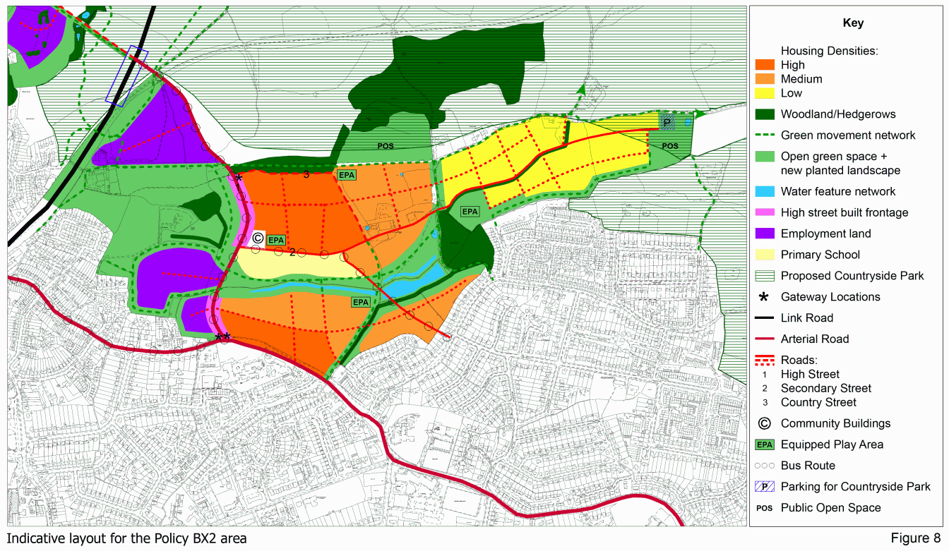
6.2 An indicative layout for the Policy BX2, which defines the broad spatial hierarchy and pattern of streets and development blocks, is described below and illustrated on Figure 8.
Movement framework
6.3 Central to the proposals for this area is a highly "legible" street structure. The spur from the Link Road to Wrestwood Road is for all traffic and will provide access to the employment areas.
6.4 A secondary street, leading into the residential area from the High Street, will run east-west through to the Countryside Park in the east. An arm off it will connect to Pebsham Lane via the 'stub' opposite Seabourne Road. This will enable connectivity to local services and avoid overloading the Pebsham Lane/Wrestwood Road junction. Rat-running will be avoided by ensuring low traffic speeds through street design.
High Street area
6.5 Further consideration of the form and location of the 'neighbourhood centre' has concluded that it is best sited along the arterial road from the Link Road to Wrestwood Road. This should take on a "High Street" character, providing for a mix of residential and commercial uses and strengthening the links between the uses on either side. Its focus should be close to the junction with the residential 'secondary street' to the east.
6.6 The form of the street must recognise the high traffic levels along it, but still designed to provide an active commercial street.
6.7 Traffic volumes will warrant segregated pedestrian and cycle routes with formal crossing places. Wider pavements areas should be provided for seating, cycle stands, display areas, etc.
6.8 A wide, grass-verged, tree-lined street will provide environmental and visual quality, as well as acting as a buffer to pedestrian routes and accommodation along it.
6.9 Behind these verges and pavements, the core of the High Street should have a continuous building line, punctured by entrances to the commercial/light industrial sites to the south east, with private space and parking to the rear. Retail units should be mainly on the eastern side, with offices, possibly with flats over, located more on the west.
6.10 Buildings should be of a sufficient height to create a sense of enclosure. Open green space on the western side of the street opposite the secondary street junction will act as a foil to the denser development.
6.11 No quantum for retail provision has been set at this stage, as this will depend on the housing numbers and type/scale of employment that comes forward. As a minimum, a small foodstore and space for small businesses such as a pharmacy, newsagents, hairdressers, hot food take away and cafes and should be provided in a commercial 'core' along the High Street.
6.12 To allow retail space to be responsive to need as the neighbourhood grows, it is suggested that ground floor units be flexible in design to accommodate alternatives of a shop, small office or house.
6.13 Traditionally, pubs have provided a centre of social activity in a community, as well as a physical landmark to orientate visitors. A new pub to serve the area could provide such a social hub. The optimum location would be at the north end of the high street, close to the countryside for an attractive outlook but easily accessible to both residential and employment areas.
6.14 To both encourage mixed-use activity and economic diversity and vibrancy, live-work units will be welcomed on and close to High Street. These should have dedicated workspace, the use of which will be appropriately controlled.
6.15 Parking should be shared wherever possible between facilities, and should be located largely to the rear of buildings, with limited on-street parking.
Movement and green space
6.16 The design of the junction of the High Street with the Link Road will need to be coordinated with the emerging scheme design to ensure an efficient and cohesive approach. The exact junction position is yet to be determined but will be in the area shown on Figure 8.
6.17 An important design feature of the Link Road will be to facilitate east-west pedestrian, cycle and equestrian movements. As well as mitigating against a severance effect, this is to enable the "country avenue" to continue around the town, to provide non-car access to the countryside park and to the new business areas and local services.
6.18 The main street through the residential area should be wide to allow easy pedestrian movement and circulation, and be part of the bus route.
6.19 It will follow the contours and have a more urban form near the High Street and community buildings, gradually changing to a looser and more rural form in the east. It should be punctuated by well-defined spaces, such as squares, open areas and landmark buildings at key nodes. It should be designed so as not to provide an alternative to the High Street and Wrestwood Road for through traffic. This will include ensuring low vehicle speeds. Variation in building lines will assist this.
6.20 East of Worsham Lane/Boulder Cottage, it will extend alongside the existing hedgeline as a rural lane, bounded by flush setts rather than kerbstones.
6.21 A variety of residential streets, mews and lanes will be fed by this, again taking advantage of the main east-west axis. They should look to apply 'Home Zone' principles, with 20mph speed limits.
6.22 Worsham Lane is not suited to main road use. Its landscape setting should be enhanced to serve as a strong north-south corridor from Pebsham to the Countryside Park. This will help preserve the setting and habitat value of Roundacre Wood, and encourage walking, cycling and horse-riding access to the Park. The northern section of Worsham Lane also forms part of the east-west "country lane" that contains built development.
6.23 This country lane should carry only limited traffic, and its extension both towards the Countryside Park and westwards to the High Street should follow the southern side of the more recent tree belt. It should be designed to be free of kerbs, with a footpath on its southern side. It will be either unlit or have low level lighting.
6.24 Cycle routes and footpaths should be integral to the layout, often defined through green corridors and along lanes or hedgerows. A priority is to retain and enhance the 1066 Walk.
6.25 Central to the development strategy is the creation of a greenspace corridor along the line of the Pebsham Stream, linking Roundacre Wood to the east with the High Street and The Mount to the west.
6.26 This will be "multi-functional" in that it will provide:
- a visual amenity and open break in the urban area
- a landmark to help "read" the layout of the development
- for several drainage ponds to control surface water run-off and provide fishing opportunities
- for a range of recreational spaces including sports pitches and children's play areas
- attractive waterside walks and cycle ways to local facilities and jobs
- for the movement of wildlife through the site
6.27 Where this corridor crosses the High Street, it should create a large, relatively formal green space bounded by community uses on one side and residential and offices/employment users on the other, leading up towards the Mount, where this space should become softer and more rural in character. The Stream crossing should be by an open-span bridge to accommodate both water flow and wildlife.
6.28 The woodland areas should all be retained and, in the case of that around The Mount, be supplemented on the elevated slopes. Active management will be required of Roundacre Wood.
6.29 Edges of the existing woodland should be protected with a clear green buffer, while new significant areas of woodland could be planted in areas to be identified.
6.30 Where movement and other landscape corridors are adjacent to allocated development areas, they should have appropriately designed properties fronting on to them to ensure overlooking and 'ownership'.
Residential development
6.31 Within the residential area, advantage should be taken of the combination of landform and site orientation to maximise passive solar gain through a core east-west road layout.
6.32 A mix of accommodation types and sizes is required as set in the Housing principles.
6.33 In terms of tenure, the Council will require 40% to be affordable, the balance being open market housing.
6.34 Taking into account both the relatively little affordable housing there is in the locality and the vision for the development to help retain young people to support economic activity objectives, and support their aspirations to get "on the housing ladder", it is considered that a broadly even split between social rented and shared ownership affordable housing is appropriate, with at least half being the former. That is:
- social rented = 20%
- shared ownership = 20%
- open market = 60%
6.35 The movement framework promotes a loose grid urban structure of streets using the natural contours and creative interesting internal views and views out to the countryside beyond, rather than a straight imposed grid pattern. Block sizes are proposed to be larger toward the east and of finer grain around the high street. Orientation should maximise solar gain.
6.36 At the south-eastern edge lies a critical boundary with the existing low density built form of Pebsham, to which the new development, through building massing, siting, scale and landscape treatment, will need to respond positively.
6.37 In terms of scale, height and massing, a minimum three storeys should be achieved along the high street with some four storey in key landmark locations. Housing along secondary street should be two and three storey and largely two storey toward the east.
6.38 Property close to the High Street is to be relatively fine grain and compatible with a mixed use/residential area. Development to a larger footprint can be created in courtyards accessed from and located behind the high street. There should be a variety in design and roofscape to create interesting views.
6.39 Density will be greatest at the more urban centres of the development; along the High Street, Wrestwood Road and along Secondary Street (which will also be public transport routes), and will gradually decrease as a response to the more rural character of the fringes of the site.
6.40 As a guide, and for statistical purposes, higher densities are regarded as 50 dwellings per hectare (dph), medium densities as 40 dph and lower densities as 30dph. Figure 8 illustrates the general areas of the above densities ranges.
6.41 At these densities, the amount of housing would be some 1,075 dwellings, some 10% more than the minimum figure in the Local Plan.
6.42 The design implications of this will be mixes including flats and terrace housing in the higher density areas along and close to the High Street, moving to smaller mews-type terraces and more family housing in the lower density areas. However, each 'zone' within the residential area should provide a mix of house sizes.
6.43 The Brief does not seek to prescribe a particular architectural style to new development, rather to define the place-making qualities that the buildings should embody. Indeed, architectural styles may vary within the site as a response to the transition from urban to rural character, or the timed phasing or initiator of different developments.
6.44 Fundamentally, residential buildings will be expected to create and contribute to active and legible streetscapes, with well-defined fronts and backs, and public and private curtilages.
6.45 Architecturally strong, confident elevations are expected along main movement corridors, with more individualistic designs along the country lane. There is also scope for more innovative design at eastern end as this is adjacent to the Countryside Park and self-contained.
6.46 The listed Boulder Cottage should be retained and its setting protected and responded to appropriately within the development in terms of scale and siting of new buildings. This will be achieved in part by extending the main greenspace corridor up to it and by retaining Worsham Lane as a "green route" with only limited, frontage development accessed from it.
6.47 Notable existing buildings should be sensitively integrated within the development. A couple of the small barns at Upper Worsham Farm and a fine barn and associated outbuildings at Lower Worsham Farm towards the easternmost end of the site are worth retaining in terms of architectural merit and reflect the long agricultural history of the site.
6.48 The scale and siting of development and open space adjacent to these buildings will need to respect their intrinsic character.
Community facilities
6.49 The development will support a new one-form entry primary school, although the County Council wishes to reserve the possibility of a future extension to two-form entry. This would best be situated close to the high street and adjacent to the main green space corridor, which will incorporate a footway and cycleway. As it will be such a landmark building, it should fully reflect the sustainability credentials of the development. This may best be achieved by a design competition.
6.50 A nursery school is also envisaged to support families in the area and may be linked to the primary school.
6.51 Other community buildings may be sought here to serve both new and existing residents - youth centre, church, scouts/guides, etc. It may well not be practicable to accommodate them all in a single community building. Therefore, a generous area is reserved for such community uses in total, which will include actual provision of the community hall. To encourage lower car use and integration, this is close to the high street and the primary school and a play area.
6.52 There is also the prospect of commercial leisure facilities (e.g. gym, health centre) which could be accommodated along the High Street if no suitable sites exist in the town or district centres.
6.53 There should be easy access on foot between all facilities, with all public realm designed for a safe, secure and attractive environment.
6.54 All community buildings should be designed to front on to the street or public space. The school building will need to present a strong public face to the street. Meanwhile its private face to the south-east should be looser and respond positively to the adjacent green corridor and other ecologically rich areas.
Employment areas
6.55 Early release of the business sites in this area is a vital part of the overall strategy for employment-led growth.
6.56 As the character assessment showed, there are distinct topographical and landscape differences between the land closer to the proposed Link Road (northern area) and that nearer Wrestwood Road (southern area). Therefore, development in these areas will fulfil somewhat different markets and have varying requirements.
Southern Area
6.57 This area is divided into two by an existing hedge line, although there should still be at least footpath connections between them.
6.58 Given the proximity of residential areas to the west and south, business uses will be restricted to light manufacturing and offices. Some small-scale distribution activity will be acceptable away from the residential boundaries where hours of operation may be detrimental to residential amenities.
6.59 The level ground may accommodate a range of buildings, although building sizes and heights should be limited around the edges (to 2,000sqm and 7m eaves heights) to avoid presenting an over-bearing presence.
6.60 The height and mass of buildings should also be compatible with the street scene character of the High Street.
6.61 Significant landscaping belts, planted with indigenous tree species should be created around the development areas to provide a buffer to existing housing, soften the visual impact of commercial buildings, accommodate cycle/footpath links to local services, and provide for the movement of protected animals.
Northern Area
6.62 The main characteristics of employment uses in this area will be the overall high quality of development.
6.63 It is in a pivotal position at the gateway to the town and adjacent the junction with the new Link Road and should therefore make a positive statement about the economic vibrancy of Bexhill.
6.64 It is expected to attract high quality occupiers wanting a prestige location, well-designed buildings and an attractive environment.
6.65 New strategic woodland planting on the higher land will strengthen the green backdrop to development.
6.66 This position and north sloping ground means the area is most suited to office uses and clean manufacturing uses, such as technology industries. These would have block sizes of 100 - 500 sqm and be of a form which can most successfully be integrated into the landscape.
6.67 A significant proportion of this area is expected to be for office purposes, while large, warehouse-type structures and external storage would be unacceptable because of its potentially wide area of visual impact.
6.68 The primary access should be off the northern end of the proposed arterial road. Attractive walking/cycle links through the site should maximise the area's connectivity. Development along the north-eastern boundary of the site should follow a 'High Street' form, and help provide physical and social connections between residential and commercial accommodation.
6.69 Parking should be predominantly contained behind buildings and should not be prominent in views into the site from the north.
6.70 Design must respond to gateway location, with particular consideration for the roofline and long views. Buildings on the northern edge of the site must display design excellence and confidence, contemporary in style.
6.71 Within the site, buildings may be clustered around hard landscaped spaces, in a contemporary interpretation of farm courtyards. They should be cut in to the slope.
6.72 Alignment, orientation and heights of buildings should respond positively to the sloping site to create interesting internal views and variety. Roofs should be dark and present an irregular profile in views from the north.
6.73 At the higher end of the site, buildings should be designed around the retained Glovers Farmhouse to create a positive, characterful place here. The farmhouse itself may be suitable for conversion to office or community use.
6.74 The highest parts of the site should remain undeveloped and further tree planting undertaken to reinforce the green backdrop and ridgeline.
6.75 The indicative layout at Figure 8 is likely to represent a total floorspace of 23,900sq.m. for the combined developable employment areas (excluding structural landscape buffer areas) of virtually 8 hectares. It is 9% more than required in the Local Plan. (This assumes an average 30% building:site area, which is considered a reasonable density of development given limiting topographical, visual and other factors, especially in the larger northern area.