North East Bexhill Masterplan
(5) 7. Land North of Sidley
7.1 As discussed earlier, the greater part of this area is well contained, north-facing ground and largely separated from residential areas to the south by woodlands and open spaces. These factors mean that, with a new road access to the Link Road, the area is well suited to provide for future employment development.
7.2 However, the Local Plan recognises that the south-western area around Preston Hall Farm itself is more related to the fairly recent housing off Watermill Lane and, hence, is allocated for residential purposes.
Movement framework
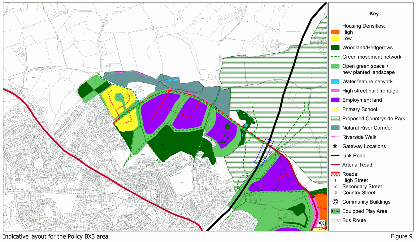
7.3 Vehicular access is from the Link Road. This route, which will constitute an outer perimeter road around the built-up area, should take the form of a wide. tree-lined "country avenue".
7.4 It should provide for all vehicles, with a single carriageway road set within generous landscaped areas accommodating a segregated cycleway and footpath, as well as equestrian routes.
7.5 The Country Avenue will run from a junction with the Link Road across the lower slopes of the adjacent field, which will remain open land as part of the Countryside Park. It will extend westwards, following the Combe valley towards Preston Hall, curving to keep a little above the valley bottom.
7.6 A road will extend southwards from the Country Avenue, around the larger business site, to give access to the new residential area off Watermil Lane.
7.7 The design of the junction of the High Street with the Link Road will be coordinated with East Sussex County Council's proposals. It is anticipated to be signal controlled. Although the exact junction position is yet to be determined but will be in the area shown on Figure 9.
7.8 It should also facilitate the continuation of the east-west pedestrian, cycle and equestrian routes associated with the Country Avenue.
7.9 High quality linkages with facilities and services in Sidley are vital and will be achieved by:
- Upgrading Buckholt Lane as the main footpath, cycleway and bridleway route from Sidley to employment areas and countryside
- Upgrading the existing footpaths from Watermill Lane
- Creating an attractive pedestrian/cycle route from Watergate through a linear green space and new housing to the business areas
- Enabling further consideration of new housing gaining access off Watermill Lane
- Creating links between sites
7.10 The movement framework is shown on the indicative layout at Figure 9.
Green space
7.11 Existing landscape structure, features and ecological habitats will be retained and enhanced, with significant "buffer" landscaping belts created around the boundaries, as key features of the area.
7.12 The large Levetts Wood and other woodlands will be retained and will form key nodes on the green space network. Strengthening existing tree belts will also provide informal amenity space for the commercial development. They are to be complemented by new green links to provide a series of connected spaces and corridors.
7.13 These will soften the visual impact of commercial buildings (both by partial screening and physical separation), preserve generous areas for the movement of wildlife through the site, and accommodate attractive cycle/footpath links.
7.14 A high level of grass surface in the employment areas, combined with creation of water features will both "soften" development and, together with ponds, help address drainage issues.
7.15 The Countryside Avenue itself will be designed with a strong landscape strategy to reflect its rural location.
7.16 Land along the Combe stream to the north of development should be retained as an amenity/wildlife corridor. This includes land around Pebsham Hall and Cottage which extends to Watermill Lane and will connect with the public footpath that heads west from that point.
Employment areas
7.17 There are effectively three discrete employment areas, being defined by substantial separating tree belts. One of these follows Buckholt Lane and the other, to the west, follows the line of a tributary of the Combe stream.
7.18 The high degree of containment of each of the "cells" for business development allows different characters - and uses - to be established in each.
7.19 The mix is not prescribed at this time but is expected to be mainly light manufacturing. Other industrial and distribution activities may be acceptable subject to the Local Planning Authority being satisfied that they would not have an adverse impact on residential amenities.
7.20 Office uses would be entirely acceptable in these areas and the possibility of a large-scale office development should be provided for in developing more detailed layout plans.
7.21 The gently sloping ground may still accommodate a range of building sizes, but larger buildings should be cut into the slope to minimise their height and associated visual impact.
7.22 Buildings should also be set within a strong landscape structure both through the site and around its perimeter to minimise its visual impact. This would most appropriately take the form of buildings clustered around a predominantly rural natural grassed informal central space to retain 'woodland clearing' site character.
7.23 Flexible building design is encouraged, to suit a variety of possible business requirements. Development should be well set back from the Country Avenue.
7.24 Each business area will have its own access off the Country Avenue. The central and western areas should also have a connecting road to assist circulation.
7.25 The combined area of the business sites is 9.35 hectares. At an average building floorspace:site ratio of 30%, this equates to a total floorspace of 28,000sq.m. for the Policy Area. This is marginally more than the 26,000sq.m. anticipated in the Local Plan.
Housing area
7.26 This area relates mainly to the adjacent housing off Watermill Lane. Its development will create a small residential enclave drawing on the positive natural characteristics of the site.
7.27 The form of development should both reflect the transition from the higher density, more suburban of north Sidley to the countryside beyond, and bring the countryside into Sidley.
7.28 Access will be provided from the County Avenue, although to better connect the development with local services, the possibility of vehicular access from the neighbouring existing residential areas to the west is provided for, subject to detailed transport assessment.
7.29 The site naturally divides into two parts, east and west of a pronounced ditch course. This will provide the main access corridor into the housing sub-areas for all modes of transport, as well as a linear green space.
7.30 A net density of 35 dwellings per hectare is proposed. For the indicative layout at Figure 9, this would mean some 135 dwellings.
7.31 The indicative layout takes full account of existing site features - the pond, (which forms a focus for a "village green"), tree cover around it, the hedgerow and the location of badger setts.
7.32 Given the tenure of existing housing in the locality, as well as low levels of economic activity, the affordable housing here should be predominantly shared ownership. This should encourage low cost home ownership and re-balance the housing and social mix.
7.33 Older children's play would most effectively be provided for by upgrading the existing 'Levetts Field' adjoining the site to the east, while younger children should benefit from open space in the development.