North East Bexhill Masterplan
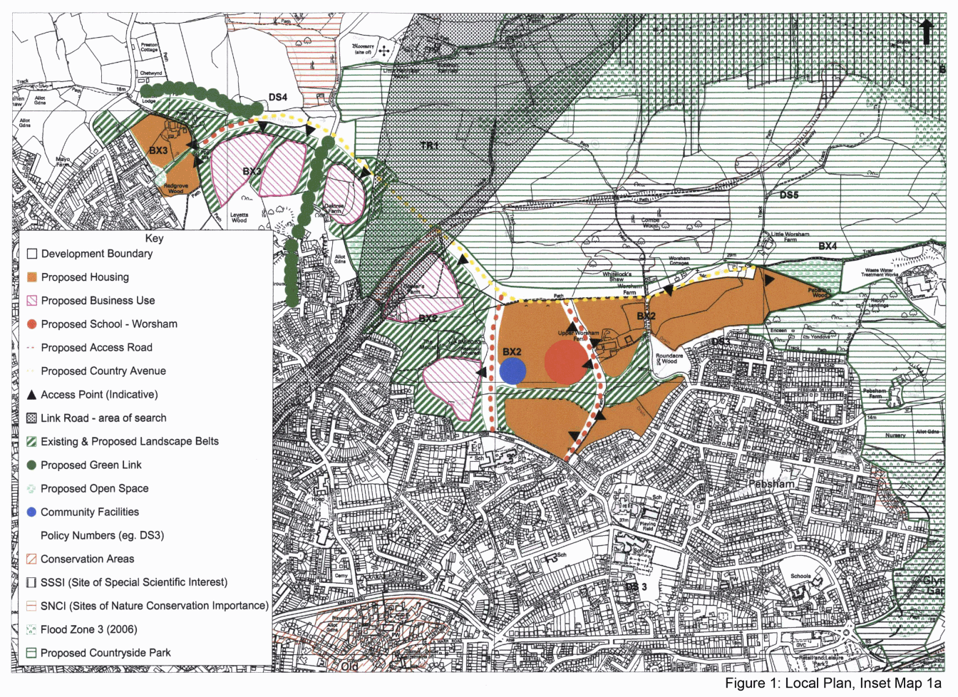
1.1 The Rother District Local Plan (July 2006) identifies some 100 hectares of land for a major urban extension to the north east of Bexhill. This is provided for through two mixed-use development allocations - Policies BX2 and BX3, and the associated 'Inset Map' (see Appendix 1 and Figure 1).
1.2 These policies have established the principle of development, and the overall scale, mix and general disposition of uses. They provide for in excess of 1,100 homes (and associated local services) and some 48,000sq.m. of business space.
1.3 This 'Masterplan' refines and elaborates on these Local Plan allocations. It covers the nature and layout of respective land uses, their relationship with each other and their surroundings, the provision of supporting infrastructure and the timing of development.
1.4 Perhaps most critically, it sets out how development should be planned comprehensively, both to be as sustainable as possible and to contribute effectively to meeting town-wide needs in terms of new job opportunities, affordable housing and in setting high standards of urban design.
1.5 Subject to feedback from public consultation (see below), this 'Masterplan' will be 'adopted' by the Council and used in determining planning applications for development in the area. It will constitute a Supplementary Planning Document (SPD) as part of the Council's Local Development Framework (LDF). As such, it will also provide a vital reference for prospective developers, service providers (such as the County Council and utility companies), as well as for local businesses and residents, all of whom have a stake in the success of this significant development for the town.
1.6 To ensure that development fulfils its potential for sustainable growth, this document presents an overall vision for the area, establishes related development principles and puts forward indicative 'masterplans' for each policy area. Guidelines for implementation, and associated infrastructure requirements, are also laid out.
Consultation arrangements
1.7 This document has been published in draft form for the purposes of public consultation.
1.8 There has been an ongoing dialogue between landowners, key public agencies and local community associations in bring forward these proposals. Members of the North East Bexhill Development Group are identified at Appendix 2.
1.9 The Council now wishes to secure the views of the wider public. It recognises that the development will be especially relevant to people living in adjacent areas of Pebsham and Sidley.
1.10 Also, in view of the strategic scale of development, the proposals are of significance to the wider community of Bexhill, and Rother, as a whole.
1.11 Other key stakeholders that the Council wishes to engage with are local firms, as the area represents the main opportunity for new business development in the Bexhill/Hastings area.
1.12 To help engage with all interested parties:
- the Draft Masterplan is being made available to a wide range of local interest groups
- the formal views of agencies are being sought
- exhibitions will be staged at Sidley and Pebsham
1.13 Comments can be made in several ways:
- by completing a Comments Form at the exhibitions
- online at www.rother.gov.uk/ldf
- by writing to the District Planning Officer, Town Hall, Bexhill-on-Sea, East Sussex, TN39 3JX
1.14 All comments should be received by 27th July 2007.