Rother Local Plan 2025-2042 – Development Strategy and Site Allocations
Part 3 – Development Strategy
5. Preparing the Development Strategy
5.1. The Development Strategy sets out the overall approach to managing growth and new development in Rother over the plan period. It identifies the main locations where new housing, employment, community facilities and other uses will be directed to and built. It is vital that the distribution of new housing and other uses helps to support the delivery of sustainable development, in line with national planning policy, and enables the achievement of the Local Plan’s Vision and Priorities.
Assessing options and the emerging preferred approach
5.2. We have considered various options for the Development Strategy for the district. The assessment of these options informed the selection of an emerging ‘preferred approach’, which was set out in the first draft Rother Local Plan (2024). This document should be referred for further information on the early-stage preparation of the Development Strategy together with supporting evidence base documents. These include the Development Strategy Background Paper, Rother Settlement Study and Sustainability Appraisal reports.
5.3. As a recap, the initial list of options was compiled with reference to the Local Plan evidence base and considered the following factors:
- The existing distribution of settlements across the district, their scale and importance in the settlement hierarchy;
- The transport network and the connectivity and interaction between settlements in relation to accessing services and facilities;
- The development potential outside the High Weald National Landscape (formerly known as Area of Outstanding Natural Beauty);
- Opportunities for new settlements, or significant extensions to existing settlements; and
- Opportunities for development on the edge of the District boundary where it is close or adjacent to other settlements.
5.4. In total, there were 13 options initially identified as high-level, ‘in principle’ strategic growth options for the Development Strategy. These are set out at Appendix 3 of this document. The options were then assessed by a Sustainability Appraisal (SA).[33]Findings from the SA and other evidence base documents were used to inform the selection of an emerging ‘preferred approach’, as set out in the first draft Rother Local Plan (2024).[34]
5.5. The Development Strategy options were considered in terms of their feasibility, amongst other criteria, by taking account of findings of the Draft HELAA (2024). Options were generally appraised less favourably where there was an insufficient supply of identified sites to enable their delivery in practical terms. In this way, the Development Strategy reflects the broad distribution of deliverable sites identified in the Draft HELAA.
Refining the preferred approach: assessing additional options
5.6. As noted previously, we received thousands of comments from the public during the first Regulation 18 consultation on the draft Rother Local Plan and have prepared an Interim Consultation Statement summarising the feedback received.
5.7. There were a wide range of comments on the proposed Development Strategy. Many respondents expressed concerns about the level of growth being planned for in Rother and the harmful impact this may have on the countryside, including the National Landscape, and on the environment. The Council acknowledges the challenge posed by the Government’s direction and policy requirements to significantly boost housing supply, but it must plan positively to do so. We have therefore considered a high number of options for the Development Strategy and assessed these for their overall sustainability. Choosing the most sustainable options will help to ensure the Local Plan sets a sound framework for growth and investment in infrastructure that responds to Rother’s local circumstances, landscape and environmental sensitivities, as well as its distinctiveness.
5.8. Through the public consultation, several additional options for the Development Strategy have been identified and these are discussed further below.
A21 Corridor option
5.9. At the first Regulation 18 consultation, an ‘A21 growth corridor’ option was considered and taken forward as part of the preferred Development Strategy. This option provided for development along the A21 trunk road within an identified corridor of settlements, together with a sustainable transport corridor (including improved sustainable travel options such as bus routes, cycling and walking infrastructure). Representations to the consultation, including from statutory bodies, raised concerns with the deliverability of this option due to a lack of identified funding and justification for potential works to the Strategic Road Network, and need for further cross-boundary discussions with relevant authorities.
5.10. The latest HELAA findings indicate that there are potential development sites in some of the larger settlements along the A21 corridor that can assist in meeting Rother’s identified development needs. As such, we consider that there is still merit in exploring an option for new development in this area. Rather than wholesale growth along all settlements within the corridor, the revised option is for focussed development only within and on the edges of those larger settlements which already have a level of services and facilities and offer existing opportunities for sustainable travel (including improvements to bus services, cycling and walking infrastructure). A revised A21 growth corridor option has therefore been prepared and assessed, as set out below:
|
New spatial development option |
Description/ vision |
Focus areas for growth in settlements/ areas of built form |
|
SDO13 – A21 corridor growth, focussed within and around existing larger settlements. |
Development along the A21 road corridor, focussed within and around existing settlements, where there is a reasonable level of local services. |
The following settlement areas: Robertsbridge/Salehurst, Hurst Green, and Flimwell. |
5.11. The Council has assessed this option through the SA process. Based on this, the Council is proposing to take this option forward for the Development Strategy. Overall, it is considered that the option will bring forward some larger sites in sustainable locations and provide for opportunities for enhanced cycle and walking routes within villages, benefiting both new and existing residents.
Strategic Gap option
5.12. It was suggested through the first Regulation 18 public consultation that opportunities should be explored to develop within the district’s strategic gaps. This option had not previously been considered for the Development Strategy. Therefore, the Council has prepared and assessed an additional option based on this representation, as set out below:
|
New spatial development option |
Description/ vision |
Focus areas for growth in settlements/ areas of built form |
|
SDO14 – Development within the strategic gaps |
Significant new development within identified strategic gaps, with new or improved linkages to the nearest settlements. |
The strategic gaps identified through the adopted Development and Site Allocations Local Plan (2019):
|
5.13. This option has been assessed through the SA process. Based on this, the Council is not proposing to take this option forward for the Development Strategy. Overall, it is considered that this option would undermine the principal intent of the strategic gaps, which is to: maintain the separate identity and distinctiveness between settlements; to maintain the strategic settlement pattern; and to prevent the coalescence of settlements. However, sites within the strategic gaps, and also more localised green gaps adopted through Neighbourhood Plans, have been assessed through the HELAA process and consequently, it is important to note that the rejection of this option as part of the overall Development Strategy will not necessarily preclude future site allocations within one or more of the strategic gaps or Neighbourhood Plan green gaps (and a subsequent re-drawing of the strategic/ green gap boundary), if a site is assessed as suitable, available and achievable for development. Furthermore, it is expected that draft Rother Local Plan (2024) Policy DEV6 will be used to assess proposals through the development management process on a case-by-case basis and this policy includes protections for ‘Strategic Gaps’ to ensure their principal functions are not compromised by new development.
Reviewing development boundaries
5.14. Feedback from the first Regulation 18 consultation also included a suggestion that the development boundaries of settlements in the district should be amended and enlarged, so to enable more development to come forward within them. The Council notes that this option has already been considered through work on the plan to-date.[35] This option forms part of the emerging Development Strategy. However, at this time, it is proposed that this approach will comprise limited updates to existing development boundaries to reflect any new site allocations within or at the edge of settlements. The extent of development boundaries is therefore being considered through the plan process and will be contingent on the final site allocations policies.
5.15. It is noted the draft Rother Local Plan (2024) set out the proposed policies to ensure new development both within and outside development boundaries, including in the countryside, is carefully managed.[36] These policies can be applied once the extent of the development boundary of settlements is established.
6. Do you have any comments on the Council’s assessment of the additional Development Strategy options? View responses
HELAA update and achieving appropriate densities
5.16. As set out above, we have reviewed and updated the HELAA to identify potential development sites and inform the Development Strategy. It is important to consider not only the distribution of new housing but also the appropriate density of housing in different locations. The NPPF states that “where there is an existing or anticipated shortage of land for meeting identified housing needs, it is especially important that planning policies and decisions avoid homes being built at low densities, and ensure that developments make optimal use of the potential of each site”.[37]
5.17. Accordingly, we have considered various density options for development in different locations of the district. This is necessary to inform approaches to maximising housing delivery, as much as reasonably practical, to meet identified needs whilst ensuring that development densities are appropriate to their context (having regard to local character, infrastructure capacity and landscape sensitivity).
Reconsidering residential densities
5.18. To support context-sensitive growth, Policy LWL1 of the draft Rother Local Plan (2024) divided Rother into five area types, each with tailored density expectations, as defined by Rother’s Density Study (2024). These density figures are measured as dwellings per hectare (dph). This is shown by Figure 7 below.
Figure 7: Density Options by Settlement Type (Policy LWL1, Draft Local Plan 2024)
|
Area Type |
Density Range (dph) |
Notes |
|
Urban areas in Bexhill, Battle and Rye |
60–90+ dph |
Strong infrastructure and public transport |
|
Suburban areas in Bexhill, Battle, Hastings Fringes and Rye |
45–75 dph |
Residential character, service proximity |
|
Live Well Locally (Urban Edge of Bexhill) |
45–60 dph |
Planned strategic growth with new infrastructure |
|
Villages with development boundaries |
25–45 dph |
Sensitive to historic and landscape context |
|
Countryside (including villages and hamlets without development boundaries) |
To reflect the existing character of the area |
Rural character and policy constraints |
5.19. Since the first Regulation 18 consultation, we have further examined whether these density expectations are appropriate, having regard to the need to optimise the use of land and maximise housing delivery.
5.20. To explore and help assess the appropriateness of different density levels across Rother’s settlement types, three strategic ‘in principle’ options have been developed, as set out in Figure 8 below:
Figure 8: Housing Density Options
|
Density option |
Principle |
Description |
|
Option A. Business as usual |
Current density standard and baseline for comparison. |
Reflects density levels based on the adopted Development and Site Allocation Local Plan. |
|
Option B. Higher density |
Higher density with a moderate uplift in development density (compared to the baseline). |
Urban areas (120dph): Compact low-rise development at the lower end of the high-density spectrum. Suburban areas (60dph): Low-rise development at the upper end of the medium-density spectrum. Live Well Locally Areas (40dph): Low-rise development at the mid-range of medium density, located on the urban edge. Village Areas (35 dph): Low-rise development at the lower end of the medium-density spectrum, with a strong emphasis on rural character, landscape sensitivity, and integration with existing village form and scale. |
|
Option C. Higher density plus |
Higher density with a significant uplift in development density (compared to the baseline) |
Urban areas (150 dph): Mid-to-high-rise development at the upper end of the high-density range. Suburban areas (75 dph): Compact low-rise development at the lower end of the high-density spectrum. Live Well Locally Areas (50 dph): Low-rise development at the higher range of medium density. Village Areas (40 dph): Compact low-rise development at the mid-range of medium density, located in rural settlements. |
5.21. The strategic density options have been established for the purpose of considering reasonable alternatives for housing density that could potentially be delivered on sites, along with their implications for housing capacity across the district. These have been based on good practice examples of higher density development achieved within the district as well as in other authority areas, including those with comparable attributes to Rother. The assessment of densities is based on assumptions of dwellings per hectare (dph) on sites, with ranges (and average densities within this range) which have been assigned for each of the area types.
5.22. Further information on the density options is set out in the evidence base, including the updated Density Study (2026). The options have also been appraised through the SA process, and the Sustainability Appraisal report published as part of this Regulation 18 consultation should be referred for further information.
5.23. This assessment of options has led to a ‘preferred approach’ (Option B) for appropriate densities in the different area types, as shown in Figure 9 below. These density assumptions have then been used to inform the site allocations and proposed indicative development capacity for each.
Figure 9: Preferred approach for housing density, by area type
|
Area Type |
Option B (Higher density) |
|
Urban areas in Bexhill, Battle and Rye |
110 – 125 dph (avg. 120) |
|
Suburban areas in Bexhill, Battle, Hastings Fringes and Rye |
45–75 dph (avg. 60) |
|
Live Well Locally (Urban Edge of Bexhill) |
35–55 dph (avg. 40) |
|
Villages with development boundaries |
25–45 dph (avg. 35) |
|
Countryside (including villages and hamlets without development boundaries) |
— |
5.24. The “preferred approach” density option is presented both as a density range and a simple average density for each area type, to reflect the diversity of housing forms and layouts within each context. The range captures the flexibility needed to respond to site-specific circumstances, design aspirations and infrastructure capacity, while the average offers a clear benchmark for strategic planning and comparative analysis. This dual approach supports more nuanced decision-making and avoids oversimplifying the character of different area types.
5.25. It is important to note that the actual density that will be delivered on sites across the district will be determined on a case-by-case basis, through the development management process and having regard to the adopted Local Plan.
5.26. To take this approach forward in the district’s towns, proposed Policy BX1 is included in this document - see Chapter 4 in the Bexhill sub-section. This defines the proposed extent of the Bexhill Urban Area, in which higher density development will be supported. Urban Areas for Battle and Rye have not yet been defined in the same way. However, we will further consider approaches to achieving appropriate higher densities in these other towns, commensurate with the standards listed in the table above.
Employment densities
5.27. In preparing the draft Local Plan, we have drawn on the Housing and Economic Development Needs Assessment (2024) for considering employment land and floorspace requirements. Where proposed site allocation policies include provision for employment floorspace, the site capacities have been informed by existing planning permissions and extant allocations, where relevant, or by applying the plot ratios for Rother as set out in the HEDNA[38], also taking account of individual site constraints.
7. Do you have any comments on the preferred approach for housing density shown in Figure 9, or on the updated Density Study (2026)? View responses
6. Development Strategy for Rother
6.1. As set out above, we have considered various options for the Development Strategy. Appendix 3 of this document provides a summary of the reasonable options considered to-date and indicates which options have been progressed and included in the ‘preferred option’, which is set out below, as the “Proposed Overall Development Strategy”. The proposed strategy comprises the combination of options which are considered by the Council to be the most appropriate, deliverable and sustainable. Minor revisions to the proposed strategy have been made since the first Regulation 18 consultation to take account of representations received, and the quantum of development has been updated to reflect the site allocations now proposed.
Proposed Strategy: Overall Development Strategy
The Council will meet the local need for all forms of housing, jobs, facilities and services by strengthening Rother’s pattern of development through a landscape-led spatial development strategy that focuses on the ‘Live Well Locally’ concept. To achieve this, a minimum of 7,881 dwellings[39] and a minimum of 74,189 sqm[40] additional employment floorspace will be constructed by the end of the Plan period in 2042.
Bexhill will continue to be a town that acts as a main transport and community hub. A network of settlements surrounding both Bexhill and Hastings (outside the local authority) will be able to access the two towns’ wider services and facilities by sustainable modes of transport.
Rye and Battle will be the centre of clusters of settlements that collectively provide what most residents need for their daily lives. Rye and Battle will continue to be key transport and community hubs, with improved active and public transport, better connecting the cluster of settlements to the towns. There are opportunities for sensitive growth in these clusters alongside new facilities and services for both new and existing residents to benefit from.
Based on these principles, the focus for growth will be in the following broad locations:
- West and North Bexhill to consolidate Bexhill as the most sustainable town, within the capacities of the existing transport network;
- The towns of Battle and Rye which act as key transport hubs, along with the clusters of villages based around them;
- Settlements on radial routes connected to the main urban areas of Bexhill and Hastings, allowing sensitive development in locations that rely on the larger towns for services and facilities;
- Development at Hastings Fringes, providing sensitive growth;
- Urban intensification and redevelopment across the district in appropriate and sustainable brownfield site locations;
- Sensitive development in other rural settlements of the district; and
- Growth along the A21 corridor, focussed within and around existing larger settlements.
The High Weald National Landscape
6.2. The overall development strategy and focus for growth necessarily includes development within the High Weald National Landscape (HWNL), which covers some 83% of the district. National Landscapes have the highest form of protection in relation to landscape and scenic beauty and the High Weald National Landscape is a national asset. Under Section 85 of the Countryside and Rights of Way Act (2000) (as amended) public bodies, including Rother District Council, have a duty to seek to further the statutory purpose (namely conservation and enhancement of natural beauty) of the HWNL.
6.3. The first draft Local Plan (2024) included Proposed Policy GTC9: High Weald National Landscape. This set out that: “all development within or affecting the setting of the High Weald National Landscape shall conserve and enhance its distinctive landscape character, ecological features, settlement pattern and scenic beauty, having particular regard to the impacts on its character components, as set out in the latest version of the High Weald Management Plan”. The policy further stated that: “development within the High Weald National Landscape should be small-scale, in keeping with the landscape and settlement pattern, and designed in a way that reflects its nationally-designated status as landscape of the highest quality, following the guidance in the High Weald Housing Design Guide and Colour Study. Major development should not take place in the HWNL save in exceptional circumstances as outlined in the NPPF”.
6.4. The supporting text to proposed policy GTC9 describes the HWNL character and key issues. It identified a key challenge as the need to balance the importance of growth and development of settlements and rural economies, with conserving and enhancing the natural beauty of the High Weald, including impacts on landscape and settlement character and features. Proposed policy GTC9 and its supporting text will be further refined through the future Regulation 19 submission version of the Local Plan.
6.5. The proposed site allocations, as presented later in this document, have been assessed in terms of their impact on the HWNL through the HELAA, although further assessment will be necessary to inform final site allocations and policy requirements. In the vast majority of cases, the proposed sites are small-scale, in line with proposed policy GTC9. However, there are a small number of sites which could be considered “major” development within the meaning of paragraph 190 of the NPPF (2024).
6.6. The NPPF confirms that major development in National Landscapes should only be permitted in exceptional circumstances and where it can be demonstrated that the development is in the public interest, having regard to the need for the development, the cost of, and scope for developing outside the designated area, and any detrimental effects. The need for housing, including affordable housing, in sustainable locations within the district could potentially be an exceptional circumstance that could allow for a major development within the HWNL, subject to it meeting the other requirements of paragraphs 189 and 190 of the NPPF (2024), proposed policy GTC9 of the draft Local Plan (2024) and the legal duty set out in the Countryside and Rights of Way Act (2000) (as amended). The assessment of potentially major site allocations will continue after the Regulation 18 consultation, informed by evidence and consultation responses, to ensure that any such sites are justified and meet the tests set out in national policy and legislation.
8. Do you have any comments on the Council’s proposed Overall Development Strategy? View responses
Summary of Growth Opportunities for Sub-Areas
6.7. Figure 10 below provides a summary of the growth opportunities and development potential of Rother and the five sub-areas, as presented later in this chapter. The table reflects the outcomes sought by the Development Strategy, which has been informed by identified development needs, an assessment of the overall sustainability of settlements[41] and site development opportunities identified through the HELAA.[42]
6.8. Further consideration will be given to the phasing and delivery of new development over the plan period as work on the Local Plan progresses. As set out in the first draft Local Plan (2024), the new plan will facilitate a considerable step-change in housing and the Council may therefore use a ‘stepped trajectory’ to manage delivery against its housing target, in line with national planning guidance. This will help to ensure that the Local Plan reflects the likely rate of housing build-out over the medium to long-term, and to ensure the timely delivery of infrastructure to support growth. Feedback from this public consultation will assist us in determining the most appropriate approach.
Figure 10: Summary of Growth Opportunities for Sub-Areas
|
Sub Area – Total Growth |
Housing (dwelling nos) (Existing allocations and sites with planning permission) |
Housing (dwellings nos) (Proposed new allocations) |
Total housing (dwelling nos) |
|
Bexhill |
1,949 |
2,815 |
4,764 |
|
Southern Rother and the Hastings Fringes |
135 |
247 |
382 |
|
Battle and surrounding settlements |
147 |
801 |
948 |
|
Rye and the eastern settlements |
332 |
459 |
791 |
|
Northern Rother settlements |
267 |
729 |
996 |
|
TOTALS |
2,830 |
5,051 |
7,881 |
|
Sub Area |
Employment floorspace (sqm) (Existing allocations and sites with planning permission) |
Employment floorspace (sqm) (Proposed new allocations) |
Total employment floorspace (sqm) |
|
Bexhill |
30,472 |
24,200 |
54,672 |
|
Southern Rother and the Hastings Fringes |
1,800 |
3,500 |
5,300 |
|
Battle and surrounding settlements |
12,971 |
0 |
12,971 |
|
Rye and the eastern settlements |
20,481 |
0 |
20,481 |
|
Northern Rother settlements |
1,200 |
3,150 |
4,350 |
|
TOTALS |
66,924 |
30,850 |
97,774 |
9. Do you have any comments on the proposed growth opportunities in the sub-areas as shown in Figure 10? View responses
Figure 11: Rother Development Strategy – Key Diagram – a pictorial representation of the development strategy
Explanatory Text:
6.9. The proposed Development Strategy seeks to maximise development opportunities while also delivering the Local Plan’s Vision, Principles and Key Spatial Objectives. Growth is directed to settlements and locations in line with the proposed strategy above, and this is informed by the overall sustainability of the settlement (as assessed in the Settlement Study) and its physical and environmental constraints, together with the number of suitable, available and achievable sites, as identified through the Council’s HELAA.
6.10. Compared to the Regulation 18 draft Local Plan published in April 2024, the number of dwellings proposed to be planned for has increased. This reflects a number of factors including:
- The election of a new Government in July 2024 with a clear aim to significantly increase housebuilding through proposed reforms to the planning system;
- The publication of a new NPPF and a new methodology for calculating the Local Housing Need (LHN) figure in December 2024, which resulted in an increase in Rother’s figure from 727 to 912 dwellings per year;
- Refinement of site assessments through the Housing and Economic Land Availability Assessment (HELAA) to ensure that all sites which are suitable, available and achievable for development are identified and taken forward as proposed site allocations;
- Identification of additional sites through the HELAA, including via a re-launched Call for Sites exercise;
- Reassessment of the density of suitable sites to ensure efficient use of land, in accordance with national planning policy;
- The consideration of representations made at the first Regulation 18 consultation which raised concern with the relatively low numbers of dwellings planned for, compared to Rother’s LHN figure.
6.11. The Development Strategy focuses growth in Bexhill, as the most sustainable town in the district, but also in Battle, Rye, the fringes of Hastings and throughout the villages. The rural setting of the district comprises differing landscapes from the network of villages and hamlets within the High Weald NL; to the coastal areas connected to the main towns. The Council is committed to supporting the growth of rural communities in a way that promotes improvements to sustainable transport options allowing residents access to neighbouring communities to share facilities and services. While the district currently has many isolated dwellings, farmsteads and commercial activities within the countryside outside of defined settlement areas, the Council will prioritise growth within or on the edge of existing well defined built-up areas with good access to services, in order to facilitate sustainable development. In line with national policy, where opportunities for appropriate and policy compliant brownfield redevelopment arise these will be considered favourably. This will allow for windfall development to come forward on a site-by-site basis.
6.12. The isolated and small-scale nature of some rural communities means that they often lack access to jobs, retail, health and care services and schools and community facilities leading to many residents having to travel to access them, mainly by private car. In addition, housing can be unaffordable, and digital coverage is sometimes a challenge. This being said, home delivery for retail needs and other services is generally increasing throughout the district, including in rural areas. More positively, rural areas can offer a sense of community, sustainable food production, access to nature, nature recovery areas and local tourism.
6.13. Key issues for rural communities which have been highlighted through early engagement on the Local Plan include:
- The ability for economic growth in rural locations to support agricultural uses alongside smaller rural based businesses.
- Providing sustainable transport options and greater accessibility to serve the facilities and services within rural towns and villages and consider the need for sufficient parking provision.
- The challenge of enabling all generations to stay in rural communities for their lifetime and particularly, enabling older people to downsize and younger generations to not be priced out of the area.
6.14. The Development Strategy views our rural communities as ‘clusters’ of settlements that cooperate like an eco-system, rather than separate places.
Five sub-areas for focussing the delivery of the Development Strategy
6.15. Rother’s proposed Development Strategy has been split into five spatial sub-areas, as shown in Figure 12, which align with the principles and focus areas of growth presented above. Each of these spatial sub-areas has their own vision statement and identified distribution of development, which follows in the remainder of this chapter. The five sub-areas comprise:
- Bexhill;
- Southern Rother and the Hastings Fringes;
- Battle and its cluster of connected settlements;
- Rye and its cluster of connected settlements; and
- Northern Rother – the settlements in the north-east of the district.
6.16. While the Development Strategy has been split into five areas, it is recognised that residents will utilise services and facilities in multiple major towns, villages and rural areas within and outside the district, to enable them to live well locally. While there is overlap, for clarity, settlements (and their identified growth potential) have been presented in only one of the five sub-areas.
6.17. In all five sub-areas there is open countryside, which has its own vision in this chapter. This relates to those areas outside of villages with development boundaries and includes farmland, woodland, hamlets and scattered development.
6.18. The visions for each of the sub-areas and the countryside have been updated from those set out in the first Regulation 18 consultation on the draft Rother Local Plan (2024), taking account of feedback received.
Figure 12: Rother District split into the Five Sub-Areas of the Development Strategy
Vision for Bexhill
Bexhill will be the key focus for sustainable residential and commercial growth, primarily within the urban area on brownfield sites and at its edges through ‘live well locally’ urban extensions on greenfield sites. There is potential to deliver some 4,764 dwellings and 54,672 sqm of employment floorspace across the Bexhill sub-area.
Supporting infrastructure will be delivered to serve the growing local and wider communities that live, work, and visit the area. Development opportunities will be realised across the town, and development densities will be maximised especially within close proximity to the main town centre and key public transport connections.
The ‘broad locations’ of west and north Bexhill will continue to grow as ‘live well locally’ urban extensions, developed sensitively and at higher densities where appropriate and sustainable to do so. Development will be well connected to the main urban areas, local neighbourhoods through sustainable transport options, including pedestrian and cycle routes (forming a Bexhill Cycle Network connected to the National cycle network) as well as by car. Growth will only occur in areas that are well connected to the existing transport network, helping to deliver improvements to the junctions and design of the existing A259 and other key routes.
Connections and accessibility to nearby settlements will be enhanced through improved public transport, active travel and road networks and station capacity. This will ensure that wider services and facilities can continue to be accessed, enabling residents to live well locally and have healthy lifestyles. There will be improvements to health inequalities and wellbeing, enabling communities to lead healthy and active lifestyles.
A strong green strategic gap will be retained between Bexhill and Hastings, with the Combe Valley Countryside Park forming an important area for recreation and biodiversity. This will avoid coalescence, ensuring that both larger settlements maintain their distinct identities and landscape character at their edges.
Where development is within the hydrological catchment area of the Pevensey Levels, higher standards of sustainable drainage systems will be delivered to avoid negative impacts on the water quality and management of this sensitive environmental area.
Bexhill will also play an active role in the Pevensey Bay to Eastbourne Coastal Management Scheme, which aims to make the coastline more resilient to coastal flooding and erosion. Through collaboration with neighbouring authorities, the Environment Agency, local communities, and partner organisations, opportunities will be explored to deliver wider community, environmental, and infrastructure benefits that align with the priorities of the Local Plan and strengthen resilience along this stretch of coastline.
6.19. Bexhill is the largest settlement in Rother District and forms its main urban area. Unlike most surrounding settlements (which are civil parishes), Bexhill does not have any parishes within it. However, it does have a Town Council (Bexhill-on-Sea Town Council), which represents the whole unparished area of Bexhill.
6.20. The figures below (Figure 13 and Figure 14) illustrate a potential development strategy for Bexhill, in terms of the numbers of dwellings and the amount of employment floorspace proposed to be delivered over the plan period. These figures have been derived from the total amount of development proposed through the site allocations, detailed later in this document.
Figure 13: Bexhill Settlement Development Strategy: Housing: Summary
|
Settlement Area |
Housing (dwelling nos) (Existing allocations and sites with planning permission) |
Housing (dwellings nos) (Proposed new allocations) |
Total housing (dwelling nos) |
|
Bexhill |
1,949 |
2,815 |
4,764 |
Figure 14: Bexhill Settlement Development Strategy: Employment: Summary
|
Settlement Area |
Employment floorspace (sqm) (Existing allocations and sites with planning permission) |
Employment floorspace (sqm) (Proposed new allocations) |
Total employment floorspace (sqm) |
|
Bexhill |
30,472 |
24,200 |
54,672 |
Sustainability Coding for Settlements (Source: Rother Settlement Study, 2024)
|
Highly sustainable |
Very Good sustainability |
Good sustainability |
Fair sustainability |
Poor sustainability |
Very Poor sustainability |
Figure 15: Bexhill sub-area
Explanatory Text:
6.21. The vision for Bexhill reflects how the town is intended to grow and develop over the next 17 years up to 2042. Bexhill is the most sustainable settlement for growth, reflected by its high scoring through the Settlement Study (2024), the only settlement in the district to be rated as “highly sustainable”.
6.22. The construction of the Bexhill-Hastings Link Road (Combe Valley Way) and associated roads connecting with the north and north-east of Bexhill have opened up development opportunities including a sustainable new urban extension with housing, business parks, a primary school and green space at North-East Bexhill (under construction) and housing and employment growth to support Sidley (North Bexhill) (allocated for development in the Development and Site Allocations Local Plan 2019). Other larger sites in the western part of Bexhill have planning permissions. The Council’s HELAA has assessed a number of sites within the urban area and adjoining or beyond the edge of the existing development boundary with a particular emphasis on opportunities for growth in north-east and west Bexhill, as suitable, available and achievable for development, and these are taken forward as proposed site allocations.
6.23. In the central part of Bexhill, the redevelopment of brownfield sites offers significant sustainability benefits, with new residents ideally situated to access a wide range of services and facilities and the public transport network. Therefore, in addition to site allocations in this part of the town, the “Bexhill Urban Area” has been identified and this is shown in Figure 16. In this location, there will be a presumption that suitable sites for residential development will achieve higher housing densities, and lower amounts of car parking and green infrastructure may be accepted (subject to local needs), compared to on more peripheral sites (which tend to be greenfield). In addition, intensification of existing development will generally be supported, subject to other Local Plan policies. The Bexhill Urban Area is the subject of Policy BX1, included later in this document.
6.24. In addition to the new Bexhill Urban Area policy and designation, two existing area-based policies for Bexhill, which remain relevant, are carried forward from the adopted DaSA Local Plan. These are the Bexhill Cultural Area (Policy BX2) and London Road-Sackville Road Enhancement Area (Policy BX3). It is noted that a policy covering Bexhill Town Centre, primary shopping area, and the two district centres of Sidley and Little Common were included as part of the first Regulation 18 consultation (draft Policy ECO3: Designated Town Centres).
Figure 16: Proposed designation of the Bexhill Urban Area
6.25. While opportunities for further development at north and west Bexhill are identified, it is considered that the east of Bexhill has reached its development limit without expanding into areas of high flood risk, the Combe Valley Countryside Park, or Sites of Special Scientific Interest (SSSI).
6.26. In west Bexhill there are other constraints in relation to the proximity to the environmental sensitivity area of the Pevensey Levels. This places higher importance on sustainable drainage measures within the identified hydrological catchment area. There are known capacity constraints on the A259 western route into Bexhill via Little Common and at the Little Common roundabout. In order to open up opportunities for development in West Bexhill, junction improvements and significant interventions, such as roundabout redesign, will be required to both alleviate road capacity and prioritise shared and active transport options on the existing network. The extent of the necessary measures and how and when they would be required will be informed by transport modelling, which will be carried out during and following this Regulation 18 consultation, and by ongoing work on the Infrastructure Delivery Plan.
6.27. To inform the first Regulation 18 consultation, the Council commissioned a discrete piece of work as part of a wider County Transport Assessment to assess the feasibility of a new transport corridor connecting the A259, west of Little Common roundabout, with Ninfield Road being delivered through the emerging Local Plan. The conclusion of the assessment was that there was currently not a reasonable prospect of the delivery of a new road or ‘multi-modal corridor’ in the West Bexhill area, because the extent of new development was not sufficient to justify the cost. As such, at this time, only sites that can access the existing road transport network have been included as deliverable site allocations within the timeframe of this Local Plan. However, a new western bypass for Bexhill remains an aspiration of the Council, in order to improve east-west transportation across the district generally, remove heavy traffic from the roads of Bexhill and release more land for development. Consequently, this option may need to will be revisited following the conclusion of the transport modelling, to be carried out during and following this Regulation 18 consultation. In any event, any development in west and north Bexhill should focus on providing sustainable, active travel options, helping shift travel patterns and contributing to better connectivity between the edges of the town and the Town Centre and district centres, providing sustainable transport routes.
6.28. In accordance with National Planning Policy, the development strategy and vision for Bexhill seeks to make as much use as possible of previously developed, or “brownfield” land to accommodate development needs. However, development on greenfield land will be necessary to meet local needs due to the lack of available brownfield sites. It will be essential to ensure that any greenfield growth forming urban extensions are not isolated standalone developments or settlement areas, and that they form part of well-connected and sustainable communities that contribute to radically reducing carbon emissions. For example, the level of new development proposed in West and North Bexhill is likely to require the provision of new primary school capacity, and a new primary school with nursery provision in each of these growth areas will significantly enhance their sustainability credentials by supporting new residents in accessing the services and facilities they need within a reasonable walking distance. While the proposed site allocation policies do identify the need for schools, the final details of how and where any new schools are to be provided will need to be determined following this Regulation 18 consultation and the further input of the County Council and local landowners.
6.29. Any development in Bexhill will need to offer enhancements and biodiversity net gain, while being sensitive to historic landscape character. There are clear opportunities to improve the nature, landscape and recreation value of adjoining greenfield land to development sites to help mitigate the loss of some open land.
6.30. The gap between Bexhill and Hastings/St Leonards is a valuable green lung between the towns. In this location approximately 600 hectares is designated as the Combe Valley Countryside Park to respond to a green infrastructure deficit in the area and provide a key area for leisure, recreation and biodiversity. While the landfill site which is central to the park has ceased to operate, there is continued use for waste collection and these sites are excluded from the Countryside Park in line with ESCC’s Waste and Minerals Local Plan. There may also be future opportunities for solar power at the landfill site, which will not in itself become publicly accessible as part of the Countryside Park for many years to come due to the time needed for it to settle and become safe.
6.31. There are neighbouring smaller settlements surrounding Bexhill that rely on services and facilities within Bexhill and/or Hastings and Battle to help meet local needs. While the majority of residents in nearby Crowhurst, Lunsford Cross, Normans Bay and Catsfield may travel by car to access services and facilities there is potential to strengthen overall public transport opportunities and build on these connections, including outside the local authority boundary such as Ninfield in Wealden. The settlements of Crowhurst and Catsfield have not been included as part of the Bexhill spatial sub-area, but are included in the Hastings and Battle sub-areas, so that identified growth is only accounted for once.
6.32. Growth in Bexhill provides a clear opportunity to:
- enable strategic planning matters such as the delivery of strategic infrastructure to be resolved through continuous cross-boundary joint working between RDC and HBC;
- increase the supply of housing and jobs;
- contribute to the enhancement of the Combe Valley Countryside Park by improving access to the countryside, support biodiversity net gain and the maintenance of the water network;
- improve the provision of sustainable bus services, cycling, wheeling and walking opportunities and connections across Bexhill as a whole, and to its neighbouring villages and settlements; and
- improve services and facilities within Bexhill, delivering important infrastructure alongside new development to ensure growth is sustainable and has wider benefits to the whole of the town.
6.33. It is recognised that some of the proposed site allocations require more detailed consideration of their impacts, including cumulative impacts. In Bexhill, a master-planning approach, potentially with design coding, will be required to ensure that connected communities that meet our Live Well Locally concept are created, particularly in the broad areas for development identified in west and north Bexhill. The Council will consider the most appropriate mechanisms to ensure master-pIanning is embedded in the development process. In seeking to maximise its potential supply, the Council wish to receive feedback through this Regulation 18 consultation on the proposed site allocations, and to further develop its evidence base to support the most suitable and sustainable sites coming forward for development.
10. Do you have any comments on the proposed Vision and development strategy for Bexhill, including the development figures shown in Figures 13 and 14? (Please note that comments on individual sites should not be made in response to this question, please see questions 17 and 18 instead) View responses
Vision for Southern Rother and the Hastings Fringes
Sensitive development will be delivered in the Hastings Fringes where it is well connected to the urban fabric of Hastings, to public and active transport routes, and to key services and facilities. Development will be appropriately designed taking account of the landscape setting of the High Weald National Landscape which wraps around the urban edge of Hastings.
Connections and accessibility to settlements in Southern Rother that are near to Hastings will be enhanced through improved public transport, active travel, and highway improvements. This will ensure that wider services and facilities can continue to be accessed, enabling residents to live well locally and have healthy lifestyles. Sensitive small-scale development will be delivered in villages, at densities consistent with the surrounding area, where it is sustainable to do so and does not negatively impact the setting of the High Weald NL.
Where greater opportunities for development arise in larger, more sustainable villages, residential development will enable enhancement to public realm and community facilities. Growth will also help support existing facilities and services in the village, ensuring health and wellbeing and community cohesion is maintained and improved.
There is potential to deliver 382 dwellings and 5,300 sqm of employment floorspace across the Southern Rother and Hastings Fringes sub-area.
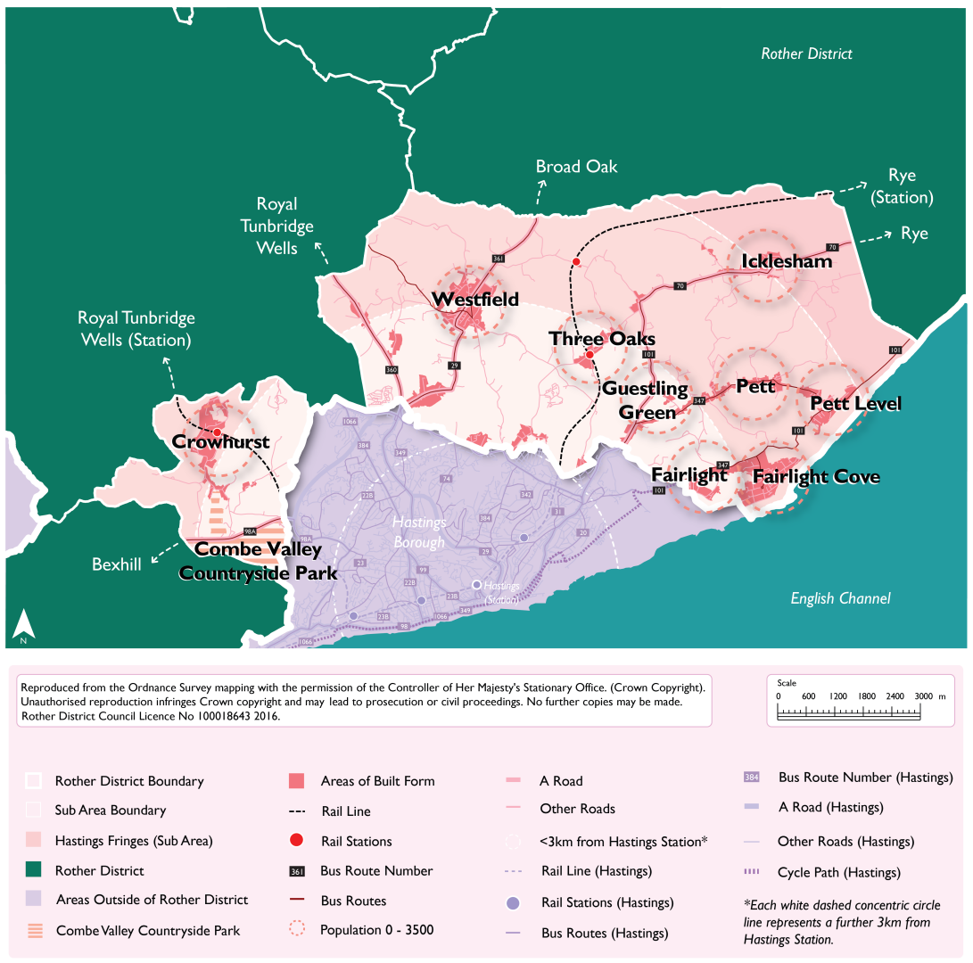
6.34. For the purposes of the development strategy, the parishes which form Southern Rother and the Hastings Fringes are Crowhurst, Fairlight, Guestling, part of Icklesham (Icklesham village only), Pett and Westfield, and all the settlements within them.
Figure 17 and Figure 18 below illustrate a potential development strategy for Southern Rother and the Hastings Fringes in terms of the numbers of dwellings and the amount of employment floorspace proposed to be delivered over the Plan Period, per settlement. These figures have been derived from the total amount of development proposed through the site allocations, detailed later in this document.
Figure 17: Southern Rother and the Hastings Fringes Development Strategy: Housing: Summary
|
Settlement Area |
Housing (dwelling nos) (Existing allocations and sites with planning permission) |
Housing (dwellings nos) (Proposed new allocations) |
Total housing (dwelling nos) |
|
Rock Lane and Austen Way (Guestling parish) |
0 |
20 |
20 |
|
Westfield |
30 |
40 |
70 |
|
Woodlands Way and Parkwood Road (Westfield parish) |
40 |
70 |
110 |
|
Crowhurst |
30 |
19 |
49 |
|
Icklesham |
0 |
58 |
58 |
|
Fairlight Cove |
35 |
0 |
35 |
|
Guestling Green |
0 |
28 |
28 |
|
Three Oaks |
0 |
12 |
12 |
|
Total Growth |
135 |
247 |
382 |
Figure 18: Southern Rother and the Hastings Fringes Development Strategy: Employment: Summary[43]
|
Settlement Areas |
Employment floorspace (sqm) (Existing allocations and sites with planning permission) |
Employment floorspace (sqm) (Proposed new allocations) |
Total employment floorspace (sqm) |
|
Rock Lane and Austen Way (Guestling parish) |
1,800 |
1,500 |
3,300 |
|
Westfield |
0 |
2,000 |
2,000 |
|
Total Growth |
1,800 |
3,500 |
5,300 |
Sustainability Coding for Settlements (Source: Rother Settlement Study, 2024)
|
Highly sustainable |
Very Good sustainability |
Good sustainability |
Fair sustainability |
Poor sustainability |
Very Poor sustainability |
Figure 19: Southern Rother and the Hastings Fringes, showing radially connected settlements to Hastings
Explanatory Text:
6.35. Southern Rother and the Hasting Fringes is characterised by a mixture of distinct villages and settlements of varying sizes but also includes development that extends from the built-up area of Hastings which, for the most part, is up to the administrative boundary.
6.36. The areas that directly extend from Hastings are defined as ‘Hastings Fringes’ for the purposes of this Local Plan as these areas are contiguous with the built-up area of Hastings. This encompasses areas within Guestling and Westfield parishes along Westfield Lane, Beaney’s Lane, Woodlands Way, Parkwood Road, Sandhurst Gardens, Stonestile Lane, Chowns Hill, Ivyhouse Lane, Rock Lane and Batchelor’s Bump.
6.37. A high proportion of the areas within the Hastings Fringes are within the High Weald National Landscape, and many areas relate more to their rural surroundings than to the urban centre of Hastings. The topography and landscape setting of some of these areas mean that it is important that most land remains as countryside. There are, however, opportunities for well-designed and sensitive residential and employment development which will be well connected to the surrounding areas.
6.38. As well as areas defined within Hastings Fringes, there are also neighbouring settlements within Southern Rother which are geographically close to Hastings. There are strong radial links with Hastings and the settlements of Crowhurst, Fairlight Cove, Guestling Green, Pett, Three Oaks and Westfield, and as such, a sensitive level of growth can be accommodated in some of these smaller settlements in locations that are considered sustainable.
6.39. The Council have identified proposed sites for allocation for both residential and employment development and the level of development proposed is summarised in Figure 17 and Figure 18. This growth is in the settlements of Crowhurst, Fairlight Cove, Guestling Green, Icklesham, Three Oaks and Westfield as well in the Hastings Fringes areas around Beaney’s Lane, Ivyhouse Lane, Rock Lane and Woodlands Way. The site- specific policies are contained in the rest of this document and set out the requirements that new development would need to meet.
6.40. Some of the proposed sites are existing allocations from either the Development and Site Allocations Local Plan or the Crowhurst Neighbourhood Plan, or are sites that have received planning permission but have yet to be built out. The sites that are already allocated have been reviewed and in some instances the level of development has been increased to be in line with the revised Density Study (2026). This is identified within the relevant site allocation policies. Many sites are newly identified having been assessed through the HELAA.
6.41. The settlements where proposed sites for allocation have been identified are in areas with a mix of good, fair and poor levels of sustainability as defined through the Settlement Study with the sites adjoining the built-up area of Hastings being generally most sustainable. The levels of development proposed are broadly consistent with these sustainability ratings with many of these settlements (Crowhurst, Guestling Green, Icklesham and Westfield) containing a primary school. Crowhurst and Three Oaks both contain a railway station, although the frequency of services at Three Oaks is lower than at Crowhurst. The sites proposed within the Hastings Fringes are in locations which can access the range of services and facilities within Hastings borough, including primary and secondary schools as well as more frequent bus services than the settlements in the rest of the Southern Rother area.
6.42. While Guestling Green and Three Oaks both score poorly in sustainability terms through the settlement study, Guestling Green does benefit from its regular bus service to Rye and Hastings and also its primary school, A small level of development is proposed in Three Oaks to help support the vitality of the settlement and the services, even if limited, within the settlement. The proposed site for allocation would require smaller units to address the current size of dwellings and would also bring a small number of affordable housing units in compliance with proposed Policy HOU2 of the draft Local Plan (2024).
6.43. No proposed sites for allocation have been identified in Pett parish or the other Hastings Fringes settlement areas identified at the start of this section. Pett is highly constrained in landscape terms, with the northern part being predominately located on a prominent ridgetop and the sloping topography meaning new development would be of high visual sensitivity and in many instances require significant groundworks to create developable sites, which would be harmful to the landscape and character of the High Weald National Landscape. Pett Level, in the southern part of the parish, is characterised by large areas of land within Flood Zone 3 as well as being adjacent to nationally and internationally protected habitats within the Dungeness, Romney Marsh and Rye Bay Ramsar site and Hastings Cliffs to Pett Beach Site of Special Scientific Interest. There are also very limited services within Pett to serve new development. Many of the sites within the remaining Hastings Fringes areas are within a countryside landscape setting where development would have a harmful impact on the High Weald National Landscape.
6.44. It is recognised that some of the proposed sites for allocation require more detailed consideration of their impacts, including cumulative impacts. This work will be developed after the Regulation 18 consultation stage. In seeking to maximise its potential supply, the Council wish to receive feedback through this Regulation 18 consultation on the site allocations that are proposed, and to further develop its evidence base to support the most suitable and sustainable sites coming forward for development.
11. Do you have any comments on the proposed Vision and development strategy for Southern Rother and the Hastings Fringes, including the development figures shown in Figures 17 and 18? (Please note that comments on individual sites should not be made in response to this question, please see questions 26 to 35 instead) View responses
Vision for Battle and Surrounding Settlements
Battle will retain its historical character at its core and preserve its local distinctiveness and important setting within the High Weald National Landscape. Employment opportunities will be enhanced through sensitive commercial development, including through extensions to and densification of existing employment sites. Opportunities for brownfield residential development within the urban areas of Battle will be realised with higher densities achieved in sustainable locations.
A greater amount of sensitive growth will take place south-west of Hastings Road with linked opportunities for habitat creation, restoration, enhancement and community access.
Sensitive development will be delivered in villages surrounding Battle, at densities consistent with the surrounding area, where it is sustainable and does not negatively impact the setting of the High Weald NL. A reasonable level of growth will help support improving the overall sustainability and vitality of the cluster of villages around Battle, through supporting existing services and facilities as well as delivering developer contributions for wider community benefit. This will ensure that health and wellbeing and community cohesion is maintained and improved.
There is potential to deliver 838 dwellings and 12,971 sqm of employment floorspace across the Battle and Surrounding Settlements sub-area.
6.45. The Battle and Surrounding Settlement sub-area contains the parishes of Ashburnham, Brightling, Battle, Catsfield, Dallington, Mountfield, Sedlescombe and Whatlington and all the settlements within them.
6.46. Figure 20 and Figure 21 below illustrate a potential development strategy for Battle and surrounding settlements in terms of the numbers of dwellings and the amount of employment floorspace proposed to be delivered over the Plan period. These figures have been derived from the total amount of development proposed through the site allocations, detailed later in this document.
Figure 20: Battle and Surrounding Settlements Development Strategy: Housing: Summary
|
Settlement Area |
Housing (dwelling nos) (Existing allocations and sites with planning permission) |
Housing (dwellings nos) (Proposed new allocations) |
Total housing (dwelling nos) |
|
Battle |
20 |
672 |
692 |
|
Sedlescombe |
63 |
74 |
137 |
|
Catsfield |
30 |
55 |
85 |
|
Netherfield |
34 |
0 |
34 |
|
Total Growth |
147 |
801 |
948 |
Figure 21: Battle and Surrounding Settlements Development Strategy: Employment: Summary
|
Settlement Area |
Employment floorspace (sqm) (Existing allocations and sites with planning permission) |
Employment floorspace (sqm) (Proposed new allocations) |
Total employment floorspace (sqm) |
|
Battle |
4595 |
0 |
4595 |
|
Sedlescombe |
6515 |
0 |
6515 |
|
Brightling (Parish) |
1861 |
0 |
1861 |
|
Total Growth |
12971 |
0 |
12971 |
Sustainability Coding for Settlements (Source: Rother Settlement Study, 2024)
|
Highly sustainable |
Very Good sustainability |
Good sustainability |
Fair sustainability |
Poor sustainability |
Very Poor sustainability |
Figure 22: Battle and Surrounding Settlements Development Strategy
Explanatory Text:
6.47. Residential and employment site allocations are proposed within the parishes of Battle, Brightling, Catsfield, Netherfield and Sedlescombe. A number of these sites are either existing allocations from the Development and Site Allocations Local Plan (DaSA), identified in Neighbourhood Plans, or have planning permission. Where appropriate, existing site allocation policies and planning permissions have been incorporated into the proposed policies. In some cases, development levels have been increased to align with the densities outlined in the revised Density Study (2026), as detailed in the relevant site-specific policies.
6.48. The remaining proposed site allocations comprise sites which have been identified through the HELAA process.
6.49. The sustainability scores of the settlements containing allocated sites, as defined in the Settlement Study, range from good to poor. The proposed amount of development generally reflects these sustainability ratings, with more sustainable settlements receiving a greater share of growth within the sub-area.
6.50. Battle is a relatively small, historic market town which provides an important local centre for its residents and those of surrounding villages, affording it a town centre designation. In addition, Battle is a popular tourist destination for domestic and foreign visitors. The town has a train station, but can suffer from congestion on its roads, particularly in the peak summer tourist season, as traffic is channelled along narrow roads through the historic town centre.
6.51. The whole town of Battle and the immediate surrounding countryside is within the High Weald National Landscape (NL) with large areas of woodland having Ancient Woodland and Priority Habitat designations. The town centre, the historic Battle Abbey and the designated battlefield form the historic core, which was first designated as a Conservation Area in 1971 and reviewed in 2006. Battle has historically developed, in a linear fashion along one of the principal High Weald east-west ridges, which has led to areas of the town and surrounding area being visually exposed in the landscape.
6.52. Due to the combination of Battle sitting within the HWNL, and its historic core and accessibility limitations, growth is constrained. However, there is a need to support the town’s role and economic vitality, through sensitive residential (including affordable housing) and commercial developments to increase opportunities for housing and employment locally. Battle has two sites allocated in the Battle Neighbourhood Plan, two that were allocated in the Rother Local Plan (2006), one with planning permission, in addition to eight further sites proposed in this Local Plan, comprising a mix of residential and employment allocations. Potential opportunities for larger scale development have been identified south-west of Hastings Road.
6.53. The village of Netherfield is also within Battle, and the villages of Catsfield and Sedlescombe are near to Battle. All depend on the larger town for access to a wider range of key services and facilities. A sensitive amount of residential and commercial development is proposed in these settlements.
6.54. Catsfield has one site allocated in the DaSA with two more proposed in this Local Plan. The settlement is located in the west of the district approximately 3 miles to the west of Battle. Catsfield is a historic settlement which has developed around a church located in a present day triangular road layout which provides the nucleus of the settlement, comprising Church Lane, The Green and Church Road, with further residential development branching off along Skinners Lane. The settlement contains pockets of wooded areas with Ancient Woodland and Priority Habitat designations, with the lower lying areas being at risk of surface water flooding. The settlement is relatively well-contained within the HWNL, with Church Road comprising the boundary to the HWNL. Catsfield has a good range of services including a village hall, primary school and convenience store, however its overall sustainability is constrained by a lack of employment opportunities. The proposed sites are considered to have potential for small to medium scale development which could facilitate better public transport accessibility and active travel accessibility through the settlement to the primary school.
6.55. Netherfield has two sites allocated in the Battle Neighbourhood Plan, carried forward into this Local Plan. The settlement is located to the west of the district approximately 3.5 miles north-west of Battle and has developed in a sporadic, linear fashion along Battle and Netherfield Road, latterly with the Darvel Down estate, primary school and equipped play space creating a more focussed settlement centre. Netherfield occupies an elevated, ridge top position overlooking historic fieldscapes and woodland within the sub-area, leading to it being highly visible within long distance vistas from the south of the settlement. The settlement has a good range of key services including the primary school, a village hall, playing pitch and convenience store. However, its overall sustainability is constrained by a lack of public transport provision.
6.56. Sedlescombe has seven sites allocated in the Sedlescombe Neighbourhood Plan, with four more proposed in this Local Plan. The main village is located in the centre of the parish approximately 3.5 miles east of Battle and the same distance north of Hastings. The settlement developed from the village green spreading along The Street with estates branching off Brede Lane, with pockets of wooded areas in the settlement having Ancient Woodland and Priority Habitat designations. Some areas of the settlement are particularly visible within long distance vistas from the west. Sedlescombe has a good range of services including playing pitches, a village hall and a primary school, but its relative sustainability is somewhat constrained by the level of services and public transport accessibility.
6.57. No sites within the parishes of Ashburnham, Dallington, Mountfield, or Whatlington have been identified as suitable, available and achievable through the HELAA process. This is largely due to the settlements within these parishes being particularly constrained in landscape terms, often exposed to long views within the High Weald National Landscape, and also their relatively remoteness, having a poor range and level of services.
6.58. It is recognised that some of the proposed sites for allocation require more detailed consideration of their impacts, including cumulative impacts. This work will be developed after the Regulation 18 consultation stage. In seeking to maximise its potential supply, the Council wish to receive feedback through this Regulation 18 consultation on the site allocations that are proposed, and to further develop its evidence base to support the most suitable and sustainable sites coming forward for development.
12. Do you have any comments on the proposed Vision and development strategy for Battle and Surrounding Settlements, including the development figures shown in Figures 20 and 21? (Please note that comments on individual sites should not be made in response to this question, please see questions 36 to 41 instead) View responses
Vision for Rye and the Eastern Settlements Cluster
The important historical character of Rye will be preserved and enhanced, maintaining a strong retail and services core with access to sustainable green tourism and leisure opportunities. Areas at risk from flooding and sensitive environmental areas will be protected from inappropriate development and the high-quality biodiversity and landscape designations will be sensitively managed and enhanced, including community access, through biodiversity net gains from development.
The key employment areas within Rye Harbour will be retained, along with other commercial areas across the town. This includes maintaining the viability of the Port of Rye as a working harbour, while having regard to protecting the integrity of internationally designated habitats. Key tourism areas such as Camber will be promoted through improved accessibility to reduce the dependency on the car, including better utilisation of existing cycle and pedestrian routes.
The eastern cluster of settlements will be better connected by sustainable transport infrastructure, with Rye acting as a key transport hub, and local economies will continue to grow, respecting the historic development pattern of rural communities over time. The strengthened connections to Rye as a sustainable market town, will allow for sensitive development in adjoining villages.
There is potential to deliver 791 dwellings and 20,481 sqm of employment floorspace across the Rye and Eastern Settlements Cluster sub-area.
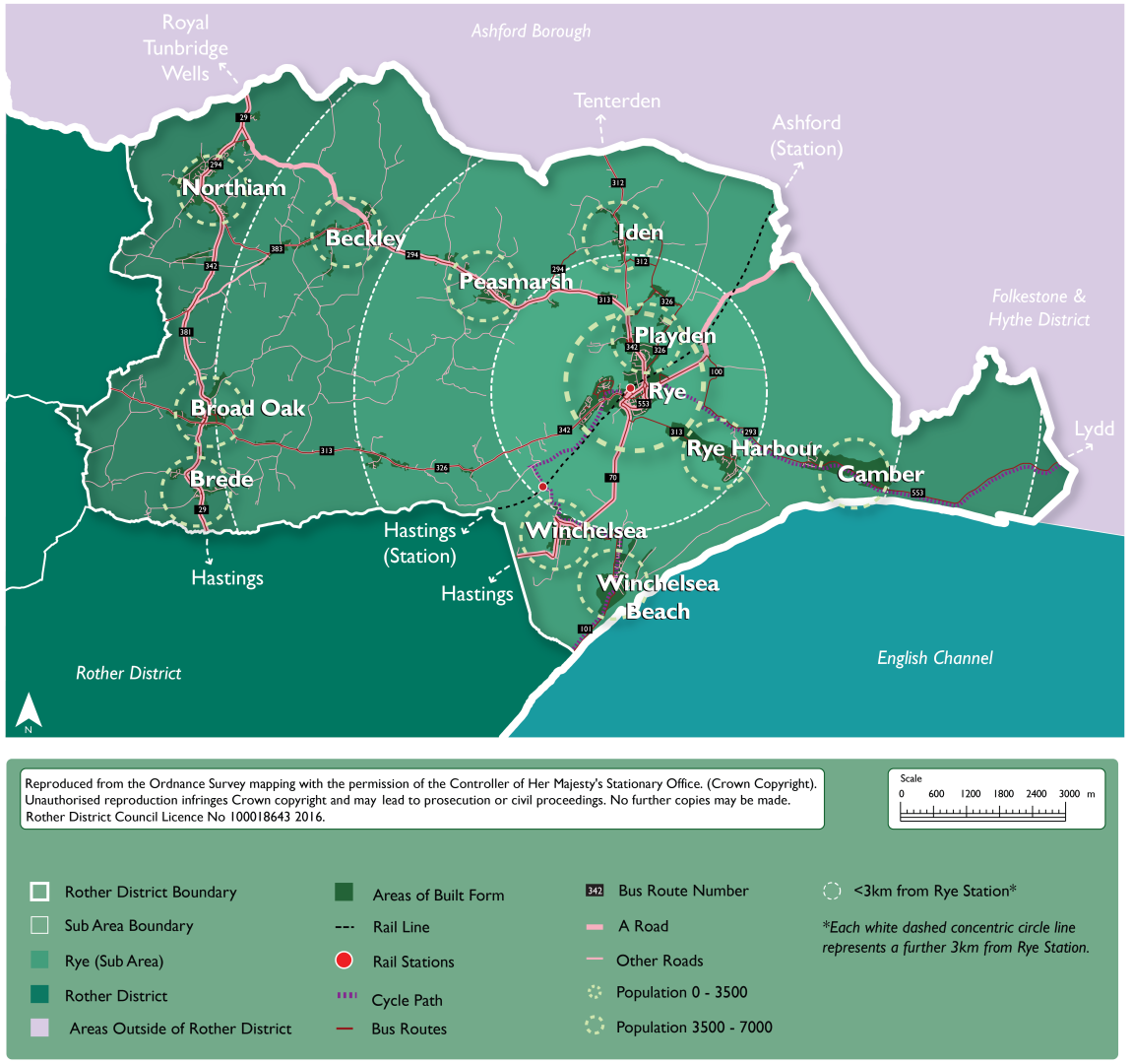
6.59. For the purposes of the development strategy, Rye and the eastern settlements cluster includes the parishes of Beckley, Brede, Camber, East Guldeford, Icklesham, Iden, Northiam, Peasmarsh, Playden, Rye, Rye Foreign and Udimore, and the settlements within them.
6.60. Figure 23 and Figure 24 below illustrate a potential development strategy for Rye and the eastern settlements cluster in terms of the numbers of dwellings and the amount of employment floorspace that is proposed to be delivered over the Plan period. These figures have been derived from the total amount of development proposed through the site allocations, detailed later in this document.
Figure 23: Rye and Surrounding Settlements Development Strategy: Housing: Summary
|
Settlement Area |
Housing (dwelling nos) (Existing allocations and sites with planning permission) |
Housing (dwellings nos) (Proposed new allocations) |
Total housing (dwelling nos) |
|
Rye |
160 |
165 |
325 |
|
Beckley |
20 |
33 |
53 |
|
Broad Oak |
29 |
90 |
119 |
|
Camber |
10 |
5 |
15 |
|
Rye Harbour |
40 |
0 |
40 |
|
Iden |
15 |
10 |
25 |
|
Northiam |
6 |
26 |
32 |
|
Peasmarsh |
52 |
91 |
143 |
|
Playden |
0 |
39 |
39 |
|
Total Growth |
332 |
459 |
791 |
Figure 24: Rye and Surrounding Settlements Development Strategy: Employment: Summary
|
Settlement Area |
Employment floorspace (sqm) (Existing allocations and sites with planning permission) |
Employment floorspace (sqm) (Proposed new allocations) |
Total employment floorspace (sqm) |
|
Rye |
3,000 |
0 |
3,000 |
|
Rye Harbour |
17,481 |
0 |
17,481 |
|
Total Growth |
20,481 |
0 |
20,481 |
Sustainability Coding for Settlements (Source: Rother Settlement Study, 2024)
|
Highly sustainable |
Very Good sustainability |
Good sustainability |
Fair sustainability |
Poor sustainability |
Very Poor sustainability |
Figure 25: Rye and the Eastern Settlements Cluster
Explanatory Text:
6.61. Rye is the only town in this sub area, with all eleven satellite parishes relying on it for many services. This is reflected in the housing and employment allocations, with Rye having the highest number of allocations in the eastern part of the district.
6.62. The allocations for Rye and the eastern parishes are either existing allocations from the Development and Site Allocations Local Plan (DaSA), identified in Neighbourhood Plans, or have planning permission. Where pertinent, existing site allocation policies and planning permissions have been incorporated into the proposed policies. In some cases, development levels have been increased to align with the densities outlined in the revised Density Study (2026), as detailed in the relevant site-specific policies.
6.63. The sustainability of the site is reflected in the quantum of development in each settlement, sustainability being one of the key threads that runs through the new Local Plan.
6.64. Rye is a historic market town in the eastern half of the district near the Kent border. The town is the main service and employment centre in eastern Rother. Rye Harbour (within Icklesham parish) is a satellite village to Rye and is located to the southeast of the town. The area surrounding Rye is heavily constrained physically by the High Weald National Landscape (NL) to the north and west, and low-lying areas at risk of flooding and designated for their habitat value to the south and east. The population of Rye Parish is recorded as being 4,480[44] in 2021. Some parts of Rye’s built-up areas encroach into other adjacent parishes (Rye Foreign and Playden). The majority of the proposed allocated sites in Rye take forward existing allocations in the Rye Neighbourhood Plan, with the density increased in line with the revised Density Study (2026).
6.65. The countryside surrounding Rye is subject to environmental designations, signifying its landscape character and conservation importance. Dungeness, Romney Marsh and Rye Bay are designated as a Special Protection Area (SPA) and wetland of international importance known as a ‘Ramsar site’. In addition, much of the surrounding area to the north and west forms part of the High Weald NL, and there are several Ancient Woodlands.
6.66. The settlements within the eastern part of the district depend on Rye for wider facilities and services. Rye also functions as a key transport hub for travel outside of the district, including by rail to London via Ashford, and Eastbourne via Hastings. While some settlements link radially to Rye, there is also a network of settlements which form a cluster, as shown in the key diagram in Figure 25 above, with Rye as a key destination. This cluster is supported by existing bus services that could be enhanced through the development strategy of the Local Plan. A sensitive level of growth can be delivered in the cluster of settlements that connect to Rye as a main transport hub. Associated sustainability improvements will be required to local services and facilities, as well as active travel measures.
6.67. Sites have been allocated in Beckley, a historic village with ribbon development straddling an ancient east-west route in the High Weald NL, located some 7.5km northwest of Rye. The village has landscape constraints, being located within the High Weald NL, and is effectively bound north and south by the Rother, Brede and Tillingham Woods Biodiversity Opportunity Area. It has a primary school, village hall, recreation ground, play area, church, and a public house in nearby Clayhill. However, residents are reliant on the larger neighbouring settlements of Peasmarsh and Northiam for shops, doctor and dentist. Two of the sites are existing allocations brought forward from the DaSA Local Plan, with the density increased in line with the revised Density Study (2026), and two new sites have come through the HELAA process.
6.68. Three sites are proposed for allocation in Broad Oak (Brede parish). Broad Oak is a small village, approximately 9km west of Rye and 12km north of Hastings. It sits wholly within the High Weald NL and the village is sited on a crest, with the land falling away most markedly to the southern open vistas of the Brede river valley. In terms of essential services, Broad Oak has a village shop, a primary school, and doctor’s surgery. Other services include two pubs (one in neighbouring Brede village), a village hall (in neighbouring Cackle Street), a pre-school nursery, a recreation ground and a bakery. The village is served by several bus services although as no service has at least 10 buses per day, the public transport connections are considered to be limited. Allocations totaling 81 new dwellings are being consulted on in Broad Oak, which will assist in maintaining the vitality of the parish.
6.69. Camber has previously had two sites allocated in the DaSA Local Plan, which are taken forward in this new plan, with one additional site included which was subject to a previous planning permission. The settlement is in the far east of the district, not far from the Kent border. It is located nearly 4km southeast of Rye, while the centre of Hastings is some 17.5km to the west. Once a quiet place of scattered bungalows and coastguard cottages, it developed with the addition of large holiday camps and caravan sites. The village has seen a lot of development since World War 2 with the building of bungalows on sand dunes, as well as infilling by modern, higher density housing. Whilst the services currently available are considered to be limited, the proposed sites will contribute to the vitality and sustainability of the village.
6.70. Rye Harbour is within Icklesham parish and has a population of approximately 817. It is just over 500m to the southeast of Rye, although the immediate linear stretch of the village is occupied by a large industrial area that straddles Harbour Road for a further 1.3km before the residential section of the village is reached. Although Rye Harbour has close economic links with nearby Rye, it is considered a distinct settlement, which is consolidated by the existing Strategic Gap between the two settlements.
6.71. While outside of the AONB, Rye Harbour has significant environmental constraints to further development. All land surrounding the settlement is either protected by international designations (SAC/SPA/Ramsar) or is within Flood Zone 3, or both. In addition, Rye Harbour Local Nature Reserve directly adjoins the settlement to the south-west and also lies to the southeast. Due to these designations, any potential for further development would be limited to areas within the settlement boundary.
6.72. Site allocations in Rye Harbour are mostly for employment land only. The existing employment area provides a substantial amount of employment and is significant for the eastern area of the district. The Harbour Road employment area has a long-established concentration of industrial uses, including some heavy industry such as the oil refinery operated by Rye Oil Ltd. Subject to safeguarding the surrounding areas of designated wildlife, as well as limitations within the local road network, the Council’s existing Local Plan is in favour of further intensification of the Harbour Road employment area, including the relocation of distribution activities from Rye. There is only one allocated housing site within Rye Harbour brought forward from the DaSA Local Plan, which will contribute to the on-going vitality of the area.
6.73. Iden is a small rural village approaching some 400 people, situated to the north of Rye. It is within the eastern end of the district, with the Kent border being 1.1km to the north. The settlement is principally linear in form, and located wholly within the High Weald NL, set on topography that gradually slopes down to the lower reaches of the Rother. Two sites are proposed for allocation in the parish, one of which benefits from planning permission.
6.74. Northiam is one of the most populated villages in the district, with an estimated population of 1,903, and supports a reasonable range of services and facilities. The village lies along a generally north to south running ridge, situated on the A28, and is 10.5km northwest of Rye. It is wholly within the High Weald NL and contains a substantial number of buildings listed for their architectural or historic interest and a Conservation Area in the southern part of the village. The landscape features long dramatic views across valleys from the enclosing ridges and spurs, and many of the sites considered through the HELAA have been rejected as they are very exposed in the National Landscape. Two sites have been put forward for allocation. One carries forward an allocation from the DaSA Local Plan,
6.75. Peasmarsh is situated within the north-east of the district, 5.5km from Rye. Compared to most villages of its scale, it has a less defined village centre, which increases the distances between services and facilities, therefore limiting the walkability of the settlement (although there are pavements on both sides of Main Street). The Main Street / School Lane triangle contains a primary school, (including a pre-school) and a pub (Horse & Cart), but other key services are located in the superstore (which also contains a post office, café, pharmacy and petrol filling station) at the north-west end of the village.
6.76. The parish is within the High Weald National Landscape and the only suitable sites for development are within or adjacent to the village itself. Four sites have been allocated in the parish; the existing services indicate that it is a sustainable location for development.
6.77. Playden is a small, historically rural village to the north of Rye, east of the A268. It is less constrained than many other settlements due to its location outside the AONB and, the settlement itself is not affected by many other designations (although areas at risk of flooding and habitat designations are on lower ground to the south-east). However, access constraints affect many parts of the settlement unless they can be accessed directly from the main road (A268) as existing lanes are narrow and/or private. While services in Rye are relatively close at around 1km, pedestrian connections to Rye along the A268 could be improved as there are narrow/missing footways in places. Two sites are proposed for allocation in Playden.
6.78. The settlements of East Guldeford, Icklesham (Winchelsea Beach), Rye Foreign and Udimore do not have proposed site allocations in the Local Plan. This is because developable sites that are suitable, available and achievable have not been identified. Sites that were submitted through the HELAA process have been found to be unsuitable for reasons such as flood risk and environmental impacts.
6.79. It is recognised that some of the proposed sites for allocation require more detailed consideration of their impacts, including cumulative impacts. This work will be developed after the Regulation 18 consultation stage. In seeking to maximise its potential supply, the Council wish to receive feedback through this Regulation 18 consultation on site allocations that are proposed, and to further develop its evidence base to support the most suitable and sustainable sites coming forward for development.
13. Do you have any comments on the proposed Vision and development strategy for Rye and the Eastern Settlements Cluster, including the development figures shown in Figures 23 and 24? (Please note that comments on individual sites should not be made in response to this question, please see questions 42 to 52 instead) View responses
Vision for Northern Rother
Northern Rother’s rural settlements and communities will continue to thrive, through sensitive residential development and growth in villages to create sustainable forms of development with a strong emphasis on protecting the landscape character and scenic beauty of the High Weald National Landscape. This will ensure that health and wellbeing and community cohesion is maintained and improved.
While many rural journeys continue to be undertaken by car, local environmental impacts are lessened due to an increase in the uptake of electric vehicles and a corresponding increase in available EV charge points. Connectivity between rural settlements and the Hastings-London rail line will be enhanced through promoting and improving sustainable and active transport infrastructure including walking, wheeling and cycling, enabling communities to lead healthy and active lifestyles.
The two stations at Etchingham and Robertsbridge will continue to act as transport hubs for wider villages in Northern Rother. Also, the area will continue to be served by the smaller Stonegate station.
There are opportunities for sensitive development in the sub-area during the timeframe of the Local Plan, where sustainable and related to an existing settlement, including those alongside the A21. Longer term (beyond the timeframe of the new Local Plan), the delivery of significant improvements to create a sustainable transport corridor could open up opportunities for future development along the A21 corridor, which could be addressed in a plan review.
There is potential to deliver 996 dwellings and 4,350 sqm of employment floorspace across the Northern Rother sub-area.
6.80. For the purposes of the development strategy, the parishes which form the Northern Rother sub-area comprise Bodiam, Burwash, Etchingham, Ewhurst, Hurst Green, Salehurst and Robertsbridge, and Ticehurst.
6.81. Figure 26 and Figure 27 below illustrate a potential development strategy for Northern Rother in terms of the numbers of dwellings and the amount of employment floorspace proposed to be delivered over the Plan period. These figures have been derived from the total amount of development proposed through the site allocations, detailed later in this document.
Figure 26: Northern Rother Settlements Development Strategy: Housing: Summary
|
Settlement Area |
Housing (dwelling nos) (Existing allocations and sites with planning permission) |
Housing (dwellings nos) (Proposed new allocations) |
Total housing (dwelling nos) |
|
Etchingham |
0 |
70 |
70 |
|
Robertsbridge |
199 |
145 |
344 |
|
Ticehurst |
5 |
54 |
59 |
|
Burwash |
0 |
64 |
64 |
|
Flimwell |
9 |
137 |
146 |
|
Hurst Green |
54 |
185 |
239 |
|
Staplecross |
0 |
33 |
33 |
|
Burwash Common |
0 |
16 |
16 |
|
Stonegate |
0 |
25 |
25 |
|
Total Growth |
267 |
729 |
996 |
Figure 27: Northern Rother Settlements Development Strategy: Employment: Summary
|
Settlement Area |
Employment floorspace (sqm) (Existing allocations and sites with planning permission) |
Employment floorspace (sqm) (Proposed new allocations) |
Total employment floorspace (sqm) |
|
Robertsbridge |
1,200 |
0 |
1,200 |
|
Flimwell |
0 |
1,650 |
1,650 |
|
Ticehurst (countryside location within parish) |
0 |
1,500 |
1,500 |
|
Total Growth |
1,200 |
3,150 |
4,350 |
Sustainability Coding for Settlements (Source: Rother Settlement Study, 2024)
|
Highly sustainable |
Very Good sustainability |
Good sustainability |
Fair sustainability |
Poor sustainability |
Very Poor sustainability |
Figure 28: Northern Rother Settlements Development Strategy
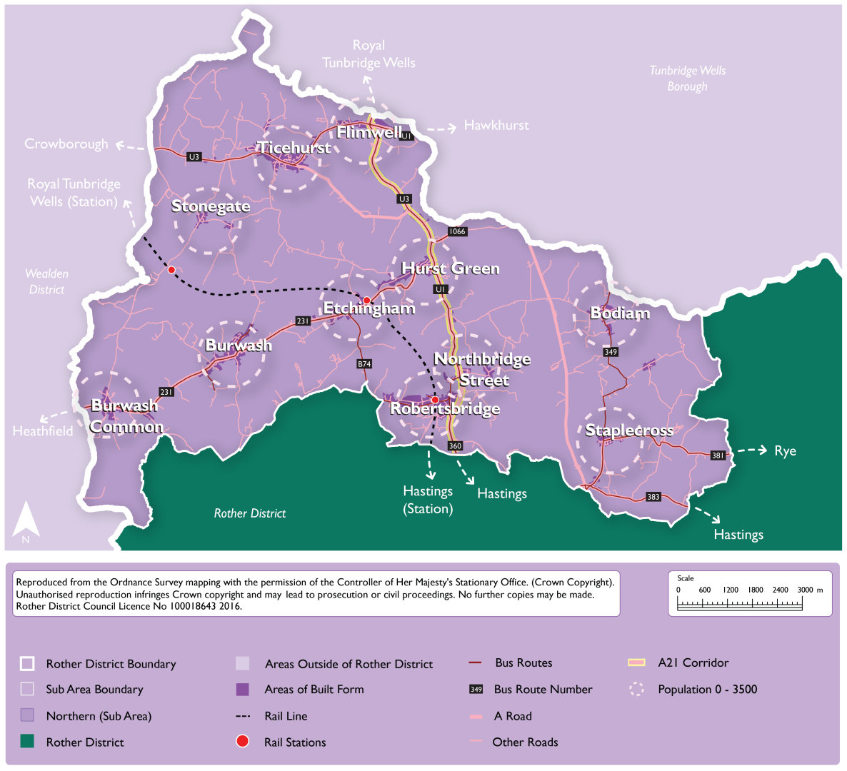
Explanatory Text:
6.82. Northern Rother is rural in its nature, with the largest villages being Ticehurst, Robertsbridge, Burwash and Hurst Green. Robertsbridge, along with Etchingham, have railway stations utilised for commuting and general travel south to Hastings and north to Tunbridge Wells and to London. These settlements are more sustainable locations for sensitive growth, however this is dependent on there being appropriate sites available, having regard to the constraints of the area including in terms of landscape and flood risk.
6.83. Northern Rother is served by a strong network of village primary schools, however, many rural primary schools are operating under-capacity. Appropriate growth in these villages is therefore an important factor in securing the long-term viability of this rural school network and communities. Residents within Northern Rother are likely to use services and facilities outside of the district to the north in Tunbridge Wells Borough and the west in Wealden District.
6.84. The A21 provides road connections between the villages north and south. In the long-term, the A21 could become a sustainable travel corridor with buses given priority, linked to walking, cycling and wheeling routes. The Transport for the South-East (TfSE) Strategic Investment Plan identifies bypasses on the A21 at Flimwell and Hurst Green as necessary transport interventions to decarbonise transport in the south-east by 2050. However, these are not currently funded and there is a lack of evidence they will come forward at any point, including during the timescale of the Local Plan.
6.85. Northern Rother experiences issues which are typical of rural communities, where some areas are isolated from services and facilities, and therefore there is a higher dependency on the private car for travel. There are, however, opportunities for sensitive growth, in Northern Rother’s larger settlements and those settlements with the potential to be made more sustainable, where there are appropriate greenfield sites on the edge of villages, as well as in settlements with brownfield sites. The benefits of growth must be balanced against the need to protect the strong landscape character of the wider area, as it is completely within the High Weald NL.
6.86. There is a clear need to support the rural economy and farming, and as such opportunities for growth, intensification, and redevelopment of commercial areas along with the diversification of farming will be supported where they are sensitive to landscape character. This can ensure that local businesses remain viable, and job opportunities are available for local people.
6.87. It is important for the Local Plan to contain a clear vision for the rural communities of Northern Rother, ensuring that policies developed within the Local Plan reflect the Council’s objectives and aspirations for the residents and businesses within rural communities, including farming communities.
6.88. The Council has identified sites for allocation, for which the proposed levels of residential and employment development are set out in Figure 26 and Figure 27. This growth is in the settlements of Burwash, Burwash Common, Etchingham, Flimwell, Hurst Green, Robertsbridge, Staplecross, Stonegate and Ticehurst. Development requirements are set out in detail in site allocation policies within this Plan.
6.89. Dwellings allocated in Northern Rother include Robertsbridge and Ticehurst Neighbourhood Plan allocations that are being taken forward, and existing large-site planning permissions that have not yet been delivered. The majority of proposed residential allocations come from new sites identified through the HELAA, although some sites form extensions to existing Neighbourhood Plan allocations.
6.90. In addition to housing, this Plan proposes allocations for new employment floorspace within Northern Rother. Some of this is taken forward from the Robertsbridge Neighbourhood Plan, as part of the Hodson’s Mill allocation. New allocations for employment are proposed within Flimwell parish, including part of a large mixed-use allocation at Hawkhurst Road, and land at Cedar Farm, which is sited on the A21 between Flimwell and Swiftsden to the south.
6.91. Robertsbridge has the highest settlement growth figure within the Northern Rother sub-area. This reflects that fact that Robertsbridge is the largest and most sustainable settlement within the sub-area, containing a primary and secondary school and a train station on the Hastings to London line. The Settlement Study classified the sustainability of Etchingham and Ticehurst as ‘Good’, with each containing a primary school. Additionally, Etchingham has an important train station on the Hastings to London line, while Ticehurst is a larger settlement and has a range of shops and services. However, the peripheral areas of both villages are significantly constrained in landscape terms and ultimately have fewer areas that are suitable for development than Hurst Green and Flimwell, which are only of ‘Fair Sustainability’ by comparison but include edge of settlement areas that are more contained within the landscape.
6.92. The Northern sub-area contains a small number of large site allocations in the National Landscape. Hurst Green village, which benefits from a primary school, includes a site allocation at ‘The Lodge’ which will form a northward village extension east of London Road up to the junction with Merriments for a residential-led mixed use development. In Flimwell, a large, multi-site mixed-use allocation is proposed to the east of the A21 junction. Importantly, these larger allocations are of a scale that they present an opportunity for new facilities, including improved pedestrian connectivity, which will improve the sustainability of these settlements.
6.93. Sites of smaller scale are identified in the ridgetop village of Burwash and the villages of Staplecross, Stonegate and Burwash Common. Burwash, Staplecross and Stonegate have primary schools, while Stonegate village is some one mile north of Stonegate railway station on the Hastings to London line.
6.94. No sites have been identified as being suitable, available or achievable through the site the HELAA in the parish and settlement of Bodiam. The predominant reasons for sites within Bodiam being considered unsuitable is that the parish is especially constrained in terms of its countryside location, being exposed to long distance views within the High Weald NL, having poor accessibility and a lack services.
6.95. It is recognised that some of the proposed sites for allocation require more detailed consideration of their impacts, including cumulative impacts. This work will be developed after the Regulation 18 consultation stage. In seeking to maximise its potential supply, the Council wish to receive feedback through this Regulation 18 consultation on the site allocations that are proposed, and to further develop its evidence base to support the most suitable and sustainable sites coming forward for development.
14. Do you have any comments on the proposed Vision and development strategy for Northern Rother, including the development figures shown in Figures 26 and 27? (Please note that comments on individual sites should not be made in response to this question, please see questions 53 to 63 instead) View responses
Vision for the Countryside
New development will be strictly limited to that which supports local agricultural, economic, tourism, community or housing needs (especially for affordable housing) and maintains or improves the rural character.
Local rural economies and farming will continue to grow sensitively over time, including through diversification, while respecting the historic development pattern of rural communities, enabling and supporting healthy food production and eating.
The countryside and coast will have improved access and recreational and leisure facilities, compatible with the rural character of the area.
Explanatory Text:
6.96. The term countryside is used here for those areas outside of defined development boundaries[45] and includes not only farmland and woodland but also scattered development outside the main confines of villages. The countryside is a defining characteristic of Rother, and there are areas of it within all five of the sub-areas.
6.97. The countryside is a productive landscape, and the prime function of the it is agriculture and the production of food. In addition, the countryside, including the undeveloped coast, has high intrinsic amenity value and is an important resource for nature conservation, leisure and tourism.
6.98. The vision for the countryside seeks to balance the many diverse pressures and competing demands on the countryside, whilst ensuring the maintenance of its farming capacity and of its attractive landscape character, to create a living, working countryside.
15. Do you have any comments on the proposed Vision for the Countryside? View responses
Proposed Strategy: Sites for Gypsies, Travellers and Travelling Showpeople
Strategy Wording:
Provision will be made for 18 permanent pitches within Rother for Gypsies and Travellers between 2025 and 2040.[46] These will be delivered as follows:
2025-2030: 7 pitches
2030-2035: 5 pitches
2035-2040: 6 pitches
In accordance with the national Planning Policy for Traveller Sites, sites or broad locations are allocated in the Local Plan to provide for this number of pitches, taking into account any pitches granted permission in the interim.
Site selection will take into account the Local Plan objectives, the future needs of occupiers and the likely availability of sites for the intended occupiers. Sites should meet the criteria set in Policy HOU11 of the Local Plan.
Proposals for transit sites and accommodation for travelling showpeople will be determined in accordance with Policy HOU11 of the Local Plan.
Explanatory Text
6.99. As set out in the Development Needs chapter of this document, the national Planning Policy for Traveller Sites (PPTS, updated 2024) requires LPAs to identify, and update annually, a supply of specific, deliverable sites sufficient to provide 5 years’ worth of sites against their locally set targets; and a supply of specific, developable sites or broad locations for years 6-10, and where possible, for years 11-15. The outstanding need figures, which derive from the East Sussex Gypsy and Traveller Accommodation Needs Assessment (GTAA, 2022), taking account of new permissions granted in the interim[47], are reflected in the Strategy above.
6.100. Sites identified to meet the need must be deliverable, either through being (or proposed to be) publicly owned, owned by gypsies/ travellers, have a willing landowner or, possibly, be part of a comprehensive development scheme that addresses a wider range of housing need.
6.101. Proposed site and broad location allocations are set out in the Chapter 4 of this document. Twelve pitches have been identified through the proposed site and broad location allocations, which would be sufficient to meet the supply required between years 1 and 10 of the Plan. Further work will be undertaken prior to the Regulation 19 consultation to finalise the site allocations, to seek to identify further pitches to accommodate the need in years 11 and beyond, and to reflect any changes.
16. Do you have any comments on the proposed strategy for Gypsies, Travelllers and Travelling Showpeople? (Please note that comments on individual sites should not be made in response to this question, please see question 64 instead) View responses
[33] Rother District Local Plan, Sustainability Appraisal Interim Report in support of the Draft (Regulation 18) Version (April 2024).
[34] Rother Local Plan 2020 – 2040, Draft (Regulation 18) Version (April 2024), Chapter 5, page 112.
[35] As set out in the Development Strategy Background Paper, spatial development strategy option SDO4 (Sustainable Settlement Growth) includes scope for the extension of settlement boundaries, where appropriate.
[36] Rother Local Plan 2020 – 2040, Draft (Regulation 18) Version (April 2024) – see for example policies DEV3 (Development boundaries) and HOU13 (New dwellings in the countryside).
[37] NPPF (December 2024), paragraph 130.
[38] HEDNA (2024), sets out a plot ratio for Rother of 0.3 for employment uses. The study also draws on the Employment Density Guide 3rd Edition (Homes and Communities Agency, 2015), which is an industry standard.
[39] This excludes the housing windfall allowance.
[40] The stated employment target in this box is the employment need figure in the HEDNA, 2024. The employment figures presented as a range for each sub-area represent the employment supply – which is higher than the need figure.
[41] Rother’s Settlement Study provides an assessment of the overall sustainability of settlements across the district.
[42] Figures are provided for housing and employment. Figures for retail are not included as evidence indicates there is no need for additional floorspace at the district level, however some site allocations make provision for this.
[43] Note: No employment floorspace allocations are proposed in the other settlements not listed.
[44] 2021 census
[45] The development boundaries are currently defined in the extant Local Plan and made Neighbourhood Plans. These may be subject to review and updating through the preparation of this Local Plan, mainly to take account of new site allocations and their boundaries.
[46] The Local Plan period is to 2042. However, the current evidence (East Sussex GTAA, 2022) only considers the period to 2040. From 2025 this does allow for 15 years, in line with the requirements of the national Planning Policy for Traveller Sites. Nevertheless, a new GTAA is underway and will be reflected in the Regulation 19 version of the new Local Plan.
[47] Further detailed in the Development Needs chapter of this document.