Main Modifications to the Proposed Submission Core Strategy
Rother District Council Local Plan - Schedule of Revised Main Modifications to the Core Strategy
This table shows the Main Modifications to the Proposed Submission Core Strategy. They appear in chapter order, and each has a unique reference number, which must be marked on the hard copy response form. Text that is proposed to be deleted is preceded by [Delete] and shown in red text. New text is preceded by [Insert] and shown in green text.
Table of Revised Main Modifications
| Modification ID | Document (Page No.) | Proposed modification | |||||||||||||||||||||||||||||||||||||||||||||||||||||||||||||||||||||||||||||||||||||||||||||||||||||||||||||||||||||||||||||||||||||||||||||||||||||||||||||||||||||||||||||||||||||||||||||||||||||||||||||||||||||||||||||||||||||||||||||||||||||||||||||||||||||||||||||||||||||||||||||||||||||||||||||||||||||||||||||||||||||||||||||||||||||||||||||||||||||||||||||||||||||||||||||||||||||||||||||||||||||||||||||||||||||||||||||||||||||||||||||||||||||||||||||||||||||||||||||||||||||||||||||||||||||||||||||||||||||||||||||||||||||||||||||||||||||||||||||||||||||||||||||||||||||||||||||||||||||||||||||||||||||||||||||||||||||||||||
|---|---|---|---|---|---|---|---|---|---|---|---|---|---|---|---|---|---|---|---|---|---|---|---|---|---|---|---|---|---|---|---|---|---|---|---|---|---|---|---|---|---|---|---|---|---|---|---|---|---|---|---|---|---|---|---|---|---|---|---|---|---|---|---|---|---|---|---|---|---|---|---|---|---|---|---|---|---|---|---|---|---|---|---|---|---|---|---|---|---|---|---|---|---|---|---|---|---|---|---|---|---|---|---|---|---|---|---|---|---|---|---|---|---|---|---|---|---|---|---|---|---|---|---|---|---|---|---|---|---|---|---|---|---|---|---|---|---|---|---|---|---|---|---|---|---|---|---|---|---|---|---|---|---|---|---|---|---|---|---|---|---|---|---|---|---|---|---|---|---|---|---|---|---|---|---|---|---|---|---|---|---|---|---|---|---|---|---|---|---|---|---|---|---|---|---|---|---|---|---|---|---|---|---|---|---|---|---|---|---|---|---|---|---|---|---|---|---|---|---|---|---|---|---|---|---|---|---|---|---|---|---|---|---|---|---|---|---|---|---|---|---|---|---|---|---|---|---|---|---|---|---|---|---|---|---|---|---|---|---|---|---|---|---|---|---|---|---|---|---|---|---|---|---|---|---|---|---|---|---|---|---|---|---|---|---|---|---|---|---|---|---|---|---|---|---|---|---|---|---|---|---|---|---|---|---|---|---|---|---|---|---|---|---|---|---|---|---|---|---|---|---|---|---|---|---|---|---|---|---|---|---|---|---|---|---|---|---|---|---|---|---|---|---|---|---|---|---|---|---|---|---|---|---|---|---|---|---|---|---|---|---|---|---|---|---|---|---|---|---|---|---|---|---|---|---|---|---|---|---|---|---|---|---|---|---|---|---|---|---|---|---|---|---|---|---|---|---|---|---|---|---|---|---|---|---|---|---|---|---|---|---|---|---|---|---|---|---|---|---|---|---|---|---|---|---|---|---|---|---|---|---|---|---|---|---|---|---|---|---|---|---|---|---|---|---|---|---|---|---|---|---|---|---|---|---|---|---|---|---|---|---|---|---|---|---|---|---|---|---|---|---|---|---|---|---|---|---|---|---|---|---|---|---|---|---|---|---|---|---|---|---|---|---|---|---|---|---|---|---|---|---|---|---|---|---|---|---|---|---|---|---|---|---|---|---|---|---|---|---|---|---|---|---|---|---|---|---|---|---|---|---|---|---|---|---|---|---|---|---|---|---|---|---|---|---|---|---|---|---|---|---|---|---|---|---|---|---|---|---|---|---|---|---|---|---|---|---|---|---|---|---|---|---|---|---|---|---|---|---|---|---|---|---|---|---|---|---|---|---|---|---|---|---|---|---|---|---|---|---|---|---|---|---|---|---|---|---|---|---|---|---|---|---|---|---|---|---|---|---|---|---|---|---|---|---|---|---|---|---|---|---|---|---|---|---|---|---|
| Chapter 2 – Policy Context | |||||||||||||||||||||||||||||||||||||||||||||||||||||||||||||||||||||||||||||||||||||||||||||||||||||||||||||||||||||||||||||||||||||||||||||||||||||||||||||||||||||||||||||||||||||||||||||||||||||||||||||||||||||||||||||||||||||||||||||||||||||||||||||||||||||||||||||||||||||||||||||||||||||||||||||||||||||||||||||||||||||||||||||||||||||||||||||||||||||||||||||||||||||||||||||||||||||||||||||||||||||||||||||||||||||||||||||||||||||||||||||||||||||||||||||||||||||||||||||||||||||||||||||||||||||||||||||||||||||||||||||||||||||||||||||||||||||||||||||||||||||||||||||||||||||||||||||||||||||||||||||||||||||||||||||||||||||||||||||
| (8) MOD 2.1 |
|
Proposed additional policy – Presumption in favour of sustainable development. Add the following policy and text after paragraph 2.4 in the Proposed Submission Core Strategy (incorporating the focused amendments):
INSERTED:
When considering development proposals, a positive approach that reflects the presumption in favour of sustainable development contained in the National Planning Policy Framework will be taken. Planning applications that accord with the policies in the Local Plan (and, where relevant, with policies in a Neighbourhood Plan) will be dealt with promptly and approved unless material considerations indicate otherwise. Account will be taken of whether policies are up-to-date, having regard to most recent monitoring information, as well as policies of the NPPF. The Council will always work proactively with applicants jointly to find solutions which mean that proposals can be approved wherever possible, and to secure development that improves the economic, social and environmental conditions in the area. |
|||||||||||||||||||||||||||||||||||||||||||||||||||||||||||||||||||||||||||||||||||||||||||||||||||||||||||||||||||||||||||||||||||||||||||||||||||||||||||||||||||||||||||||||||||||||||||||||||||||||||||||||||||||||||||||||||||||||||||||||||||||||||||||||||||||||||||||||||||||||||||||||||||||||||||||||||||||||||||||||||||||||||||||||||||||||||||||||||||||||||||||||||||||||||||||||||||||||||||||||||||||||||||||||||||||||||||||||||||||||||||||||||||||||||||||||||||||||||||||||||||||||||||||||||||||||||||||||||||||||||||||||||||||||||||||||||||||||||||||||||||||||||||||||||||||||||||||||||||||||||||||||||||||||||||||||||||||||||||
| (3) MOD 2.2 |
|
Delete paragraphs 2.6 - 2.14 and replace with new text:
DELETED:
The South East Plan 2.6 The South East Plan covers the period to 2026 and was approved by the Government in May 2009. For the region as a whole, it aims to deliver a healthier region, a more sustainable pattern of development, a dynamic and robust economy, reduced levels of social exclusion, and a more bio-diverse environment with a reduced level of natural resource consumption. 2.7 The Plan also includes a sub-regional strategy for the ‘Sussex Coast’ area from Chichester to Rye. Its extent in Rother district is shown on Figure 1. Figure 1: South East Plan ‘Sussex Coast’ Sub-Region within Rother District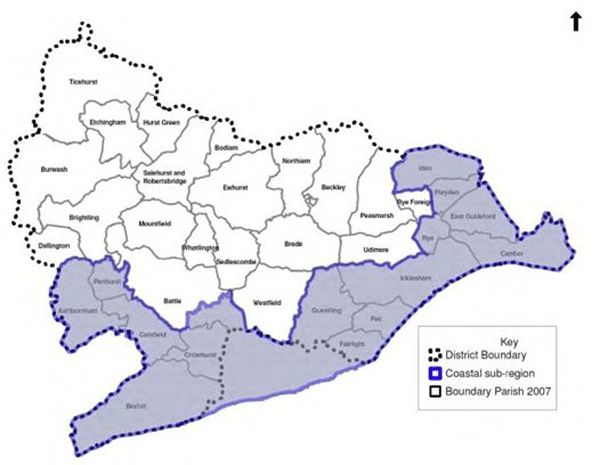
2.8 As can be seen, this sub-region embraces Bexhill and Rye and the adjacent coastal areas (as well as neighbouring Hastings). Generic South East Plan polices apply to the remaining inland parts of the district, including Battle. 2.9 Policy SP4 identifies the Sussex Coast as an area in need of regeneration. This is carried forward into the specific Sussex Coast Strategy, which prioritises the social and economic regeneration of the towns in the sub-region. Policy SCT2 specifically highlights Hastings/Bexhill as warranting continuing priority in investment decisions of the public and private sectors. 2.10 The South East Plan states that Bexhill is one of only a couple of areas of strategic scope for additional greenfield development in the Sussex Coast sub-region. This is reflected in the housing provision for the Rother part of the Sussex Coast sub-region, being 4,000 dwellings over the period 2006-2026, equivalent to an annual average of 200 dwellings. 2.11 The remaining, inland parts of Rother are identified as needing to accommodate 1,600 dwellings (80 dwellings per annum) over the same period. Hence, for Rother as a whole, the Plan requires 5,600 dwellings (280 dwellings per annum) between 2006 and 2026. It adds, at Policy SCT5, that there may be some flexibility in the precise split between the two sub-areas of the district. Government’s proposed changes to the planning system, and the South East Plan 2.12 Draft legislation in the Localism Bill proposes to abolish regional spatial strategies, including the South East Plan. Removing this regional tier of planning, and its associated “top-down” housing targets, is a strong commitment of Coalition Government. 2.13 However, at this time, the South East Plan remains effective, and a statutory part of the ‘development plan’, with which the Core Strategy should generally conform. 2.14 Even so, it is clear that there is increasing discretion for local planning authorities to re-consider their existing housing targets and to establish the right level of development for their area. Therefore, while evidence underpinning the preparation of the South East Plan is relevant background material, the Council has supplemented this through further examination of more recent information in order to determine the most appropriate future levels of development. Further details of this evidence can be found in the relevant background papers, with details on policies in the appropriate chapters of the Core Strategy.
INSERTED:
While this Strategy was prepared in the context of the South East Plan (2009), that Plan was formally revoked in March 2013. Its broad strategy to focus development in the coastal part of the District (and East Sussex generally) in order to support its regeneration is followed through in this Strategy. The South East Plan also has a bearing on this strategy insofar as development and infrastructure provisions in existing plans in the region have been prepared in general conformity with it. |
|||||||||||||||||||||||||||||||||||||||||||||||||||||||||||||||||||||||||||||||||||||||||||||||||||||||||||||||||||||||||||||||||||||||||||||||||||||||||||||||||||||||||||||||||||||||||||||||||||||||||||||||||||||||||||||||||||||||||||||||||||||||||||||||||||||||||||||||||||||||||||||||||||||||||||||||||||||||||||||||||||||||||||||||||||||||||||||||||||||||||||||||||||||||||||||||||||||||||||||||||||||||||||||||||||||||||||||||||||||||||||||||||||||||||||||||||||||||||||||||||||||||||||||||||||||||||||||||||||||||||||||||||||||||||||||||||||||||||||||||||||||||||||||||||||||||||||||||||||||||||||||||||||||||||||||||||||||||||||
| Chapter 4 – Main Issues | |||||||||||||||||||||||||||||||||||||||||||||||||||||||||||||||||||||||||||||||||||||||||||||||||||||||||||||||||||||||||||||||||||||||||||||||||||||||||||||||||||||||||||||||||||||||||||||||||||||||||||||||||||||||||||||||||||||||||||||||||||||||||||||||||||||||||||||||||||||||||||||||||||||||||||||||||||||||||||||||||||||||||||||||||||||||||||||||||||||||||||||||||||||||||||||||||||||||||||||||||||||||||||||||||||||||||||||||||||||||||||||||||||||||||||||||||||||||||||||||||||||||||||||||||||||||||||||||||||||||||||||||||||||||||||||||||||||||||||||||||||||||||||||||||||||||||||||||||||||||||||||||||||||||||||||||||||||||||||||
| (1) MOD 4.1 |
|
Delete the 2nd paragraph under 10) ‘Managing Uncertainties’ and replace with new text:
DELETED:
The most significant infrastructure uncertainty relates to the impending decision on the Bexhill to Hastings Link Road. Planning permission was granted in July 2009, but the Secretary of State’s decision following the Compulsory Purchase Order Inquiry has been delayed by the Government in the light of the review of public sector spending. The outcome will be known by the end of 2011. A significant delay, or cancellation, would have clear implications on the strategy as well as on housing and delivery and job creation. This is considered more fully in Chapters 7 and 8.
INSERTED:
During preparation of this Strategy the most significant uncertainty related to the Bexhill to Hastings Link Road. However, following planning permission in July 2009 the Secretary of State has approved the Compulsory Purchase Orders and granted final funding approval. Construction is now underway. Hence, there is now no need for related contingencies. It is scheduled to be completed in April 2015. |
|||||||||||||||||||||||||||||||||||||||||||||||||||||||||||||||||||||||||||||||||||||||||||||||||||||||||||||||||||||||||||||||||||||||||||||||||||||||||||||||||||||||||||||||||||||||||||||||||||||||||||||||||||||||||||||||||||||||||||||||||||||||||||||||||||||||||||||||||||||||||||||||||||||||||||||||||||||||||||||||||||||||||||||||||||||||||||||||||||||||||||||||||||||||||||||||||||||||||||||||||||||||||||||||||||||||||||||||||||||||||||||||||||||||||||||||||||||||||||||||||||||||||||||||||||||||||||||||||||||||||||||||||||||||||||||||||||||||||||||||||||||||||||||||||||||||||||||||||||||||||||||||||||||||||||||||||||||||||||
| Chapter 7 – Overall Spatial Strategy | |||||||||||||||||||||||||||||||||||||||||||||||||||||||||||||||||||||||||||||||||||||||||||||||||||||||||||||||||||||||||||||||||||||||||||||||||||||||||||||||||||||||||||||||||||||||||||||||||||||||||||||||||||||||||||||||||||||||||||||||||||||||||||||||||||||||||||||||||||||||||||||||||||||||||||||||||||||||||||||||||||||||||||||||||||||||||||||||||||||||||||||||||||||||||||||||||||||||||||||||||||||||||||||||||||||||||||||||||||||||||||||||||||||||||||||||||||||||||||||||||||||||||||||||||||||||||||||||||||||||||||||||||||||||||||||||||||||||||||||||||||||||||||||||||||||||||||||||||||||||||||||||||||||||||||||||||||||||||||||
| (8) MOD 7.1 |
|
Delete paragraph 7.10 and replace with new text:
DELETED:
7.10 The South East Plan sets a target for Rother district to provide 5,600 net additional dwellings between 2006 and 2026 as an appropriate contribution to the wider demand for housing. As explained in chapter 3, the South East Plan currently provides the statutory context for local planning, and hence is the starting point for consideration of the scale of housing growth appropriate locally. It further highlights that there have been significant changes in circumstances since the South East Plan was prepared, and adopted. These have warranted a fuller review of the appropriate scale of development for the district.
INSERTED:
7.10 Following the revocation of the South East Plan, the scale of growth needs to have due regard to the policies contained in the National Planning Policy Framework. The key policy reference is paragraph 47; this states that Local Plans should meet the full objectively assessed need for market and affordable housing as far as is consistent with other policies of the Framework. In accordance with this, the Council, together with Hastings Borough Council, commissioned a Strategic Housing Market Assessment (SHMA) Update in June 2013, specifically to provide a housing needs assessment. For Rother, this identified a need for 6,180 net additional dwelling over the plan period to meet the demographic trend-based assessment of need. This level of growth would also readily meet both the economic and local housing needs for new dwellings. This can be compared to a level of growth of some 4,800 dwellings previously required under the South East Plan. The capacity to accommodate this level of housing growth, as well as any shortfall in capacity in Hastings Borough, having due regard to sustainability considerations is summarised below. |
|||||||||||||||||||||||||||||||||||||||||||||||||||||||||||||||||||||||||||||||||||||||||||||||||||||||||||||||||||||||||||||||||||||||||||||||||||||||||||||||||||||||||||||||||||||||||||||||||||||||||||||||||||||||||||||||||||||||||||||||||||||||||||||||||||||||||||||||||||||||||||||||||||||||||||||||||||||||||||||||||||||||||||||||||||||||||||||||||||||||||||||||||||||||||||||||||||||||||||||||||||||||||||||||||||||||||||||||||||||||||||||||||||||||||||||||||||||||||||||||||||||||||||||||||||||||||||||||||||||||||||||||||||||||||||||||||||||||||||||||||||||||||||||||||||||||||||||||||||||||||||||||||||||||||||||||||||||||||||
| (2) MOD 7.2 |
|
Insert an additional paragraph after 7.14 to read:
INSERTED:
Whilst the amount of proposed housing development has increased since the above study, this scale of employment land release is still regarded as an appropriate minimum on the basis that it is well above trend-based forecasts and, hence, an aspirational but achievable target. Overall economic policies are set out in Chapter 16, while the scope for further employment development in rural areas is considered in Chapter 12. |
|||||||||||||||||||||||||||||||||||||||||||||||||||||||||||||||||||||||||||||||||||||||||||||||||||||||||||||||||||||||||||||||||||||||||||||||||||||||||||||||||||||||||||||||||||||||||||||||||||||||||||||||||||||||||||||||||||||||||||||||||||||||||||||||||||||||||||||||||||||||||||||||||||||||||||||||||||||||||||||||||||||||||||||||||||||||||||||||||||||||||||||||||||||||||||||||||||||||||||||||||||||||||||||||||||||||||||||||||||||||||||||||||||||||||||||||||||||||||||||||||||||||||||||||||||||||||||||||||||||||||||||||||||||||||||||||||||||||||||||||||||||||||||||||||||||||||||||||||||||||||||||||||||||||||||||||||||||||||||
| MOD 7.3 |
|
Add the following sentence to the end of paragraph 7.21: 7.21 A range of factors need to be balanced to determine the most appropriate scale of residential development, with ‘drivers’ for growth on the one hand, including demographic projections and housing market pressures, and supply constraints, notably environmental designations and infrastructure availability on the other. Critical in balancing these is the vision that local communities have for their area. These factors are reviewed, and their implications for housing development reassessed, in the Background Paper on ‘Overall Housing Provision’.INSERTED: A further assessment, which reviews both the more recent SHMA Update 2013 and the SHLAA Review 2013, is set out in the ‘Summary Appraisal of Housing Growth Potential’,(July 2013). |
|||||||||||||||||||||||||||||||||||||||||||||||||||||||||||||||||||||||||||||||||||||||||||||||||||||||||||||||||||||||||||||||||||||||||||||||||||||||||||||||||||||||||||||||||||||||||||||||||||||||||||||||||||||||||||||||||||||||||||||||||||||||||||||||||||||||||||||||||||||||||||||||||||||||||||||||||||||||||||||||||||||||||||||||||||||||||||||||||||||||||||||||||||||||||||||||||||||||||||||||||||||||||||||||||||||||||||||||||||||||||||||||||||||||||||||||||||||||||||||||||||||||||||||||||||||||||||||||||||||||||||||||||||||||||||||||||||||||||||||||||||||||||||||||||||||||||||||||||||||||||||||||||||||||||||||||||||||||||||
| (6) MOD 7.4 |
|
Delete paragraphs 7.22 and 7.23 and replace with new text:
DELETED:
7.22 This assessment, supported by the Sustainability Appraisal, concludes that the South East Plan requirement for 5,600 dwellings to be built in Rother 2006 – 2026 (with over 70% in the coastal parts, mainly Bexhill) is no longer sustainable. 7.23 There are two main reasons for this; firstly, the South East Plan assumed that the Bexhill to Hastings Link Road would be built by now, yet the earliest it can now be built is the very end of 2014. Secondly, the recent recession and on-going weak national economic growth forecasts, mean that the prospect of actually increasing on past build rates, as implied by the South East Plan target of 280 dwellings/year) (compared to actual house-building between 1991 and 2011 of only 245 dwellings per year), is both likely to be unduly optimistic and, moreover, unlikely to be matched by requisite job growth.
INSERTED:
7.22 Sustainability Appraisals have been prepared alongside successive iterations of the Strategy. In the light of the SHMA Update 2013, the Sustainability Appraisal of the Proposed Submission Core Strategy is supplemented, in respect of the potential for further housing development, by a ‘Sustainability Appraisal of the Council’s proposed revised modifications’. This most recent Appraisal supports the planned level of housing growth, recognising that it is higher than that previously proposed, largely on the basis of the greater weight given to housing objectives. However, it also concludes that higher levels of housing, which would fully meet the housing needs assessment for Rother, and potentially contribute to wider housing needs, would be unsustainable. 7.23 The main reasons for this are, firstly, that the potential for housing growth at Bexhill is as much as is likely to be achievable in housing market terms. There are also increasing uncertainties in overcoming transport capacity constraints and in achieving job growth, such that the key objective of a better balance between homes and jobs is increasingly compromised. Secondly, the potential for further growth elsewhere is seen as impacting increasingly, and significantly, on environmental designations, most notably on the conservation of the natural beauty of the High Weald AONB. Further detail about the distribution of housing growth is set out in the following section. |
|||||||||||||||||||||||||||||||||||||||||||||||||||||||||||||||||||||||||||||||||||||||||||||||||||||||||||||||||||||||||||||||||||||||||||||||||||||||||||||||||||||||||||||||||||||||||||||||||||||||||||||||||||||||||||||||||||||||||||||||||||||||||||||||||||||||||||||||||||||||||||||||||||||||||||||||||||||||||||||||||||||||||||||||||||||||||||||||||||||||||||||||||||||||||||||||||||||||||||||||||||||||||||||||||||||||||||||||||||||||||||||||||||||||||||||||||||||||||||||||||||||||||||||||||||||||||||||||||||||||||||||||||||||||||||||||||||||||||||||||||||||||||||||||||||||||||||||||||||||||||||||||||||||||||||||||||||||||||||
| (3) MOD 7.5 |
|
Amend paragraph 7.28 to read: It is concluded that an appropriate overall target for net additional housing in the district over the period from April 2011 to March 2028 (17 years) should be DELETED: 3,700 – 4,100 INSERTED: at least 5,700 dwellings, or an average of DELETED: 218 – 241 INSERTED: 335 dwellings/year. |
|||||||||||||||||||||||||||||||||||||||||||||||||||||||||||||||||||||||||||||||||||||||||||||||||||||||||||||||||||||||||||||||||||||||||||||||||||||||||||||||||||||||||||||||||||||||||||||||||||||||||||||||||||||||||||||||||||||||||||||||||||||||||||||||||||||||||||||||||||||||||||||||||||||||||||||||||||||||||||||||||||||||||||||||||||||||||||||||||||||||||||||||||||||||||||||||||||||||||||||||||||||||||||||||||||||||||||||||||||||||||||||||||||||||||||||||||||||||||||||||||||||||||||||||||||||||||||||||||||||||||||||||||||||||||||||||||||||||||||||||||||||||||||||||||||||||||||||||||||||||||||||||||||||||||||||||||||||||||||
| (7) MOD 7.6 |
|
Delete paragraphs 7.29 and 7.30 and replace new text:
DELETED:
7.29 For monitoring purposes, including calculation of the housing trajectory and land supply, the mid-point of 3,900 dwellings (an average of 229 dwellings/year) will be applied. 7.30 It is noted that, allowing for completions 2006-2011, the above housing figures represent 81%-88% of the South East Plan target 2006-2026. The reasons for this lower housing target are fully set out in the Background Paper on ‘Overall Housing Provision’, but most critically relate to delay in construction of the Bexhill to Hastings Link Road (upon which it is still contingent, as discussed further below), lower economic growth and more detailed investigations.
INSERTED:
7.29 This represents a substantial increase on previous rates of housebuilding, being 37% higher than the average of 245 dwellings per year (1991-2011). In fact, given the low rate of housing completions in the first two years of the plan period (275 dwellings), the actual rate of housing now required 2013-2028 (of 362 dwellings per year), represents an increase of 48% on past rates. Hence, and notwithstanding the constraining environmental factors, the District will see a significant boost in housing supply over the plan period. 7.30 This growth is justified primarily in terms of contributing to the projected demand for new homes, as well as in meeting the local need for housing and the need to support economic regeneration. The possibility of further opportunities for sustainable housing (as well as employment) development arising over time cannot be ruled out; hence, the requirement is expressed as a minimum for the purposes of plan-making. These will be further assessed as part of site allocations/neighbourhood planning processes. |
|||||||||||||||||||||||||||||||||||||||||||||||||||||||||||||||||||||||||||||||||||||||||||||||||||||||||||||||||||||||||||||||||||||||||||||||||||||||||||||||||||||||||||||||||||||||||||||||||||||||||||||||||||||||||||||||||||||||||||||||||||||||||||||||||||||||||||||||||||||||||||||||||||||||||||||||||||||||||||||||||||||||||||||||||||||||||||||||||||||||||||||||||||||||||||||||||||||||||||||||||||||||||||||||||||||||||||||||||||||||||||||||||||||||||||||||||||||||||||||||||||||||||||||||||||||||||||||||||||||||||||||||||||||||||||||||||||||||||||||||||||||||||||||||||||||||||||||||||||||||||||||||||||||||||||||||||||||||||||
| (3) MOD 7.7 |
|
Delete the second sentence of paragraph 7.36 and replace with new text: 7.36 In all cases, the distribution of development DELETED:is also DELETED:need INSERTED:needs to be mindful of valuable environmental and heritage assets, as well as infrastructure availability.DELETED: A better understanding of opportunities for development has been achieved via work on the Strategic Housing Land Availability Assessment (SHLAA). INSERTED: Potential sites to deliver the housing strategy are identified in the Strategic Housing Land Availability (SHLAA) Review 2013. These, as well as other sites, will be further assessed as part of site allocations/neighbourhood planning processes to determine whether, and if so how, they will be duly brought forward. There will be public consultation as part of these processes. |
|||||||||||||||||||||||||||||||||||||||||||||||||||||||||||||||||||||||||||||||||||||||||||||||||||||||||||||||||||||||||||||||||||||||||||||||||||||||||||||||||||||||||||||||||||||||||||||||||||||||||||||||||||||||||||||||||||||||||||||||||||||||||||||||||||||||||||||||||||||||||||||||||||||||||||||||||||||||||||||||||||||||||||||||||||||||||||||||||||||||||||||||||||||||||||||||||||||||||||||||||||||||||||||||||||||||||||||||||||||||||||||||||||||||||||||||||||||||||||||||||||||||||||||||||||||||||||||||||||||||||||||||||||||||||||||||||||||||||||||||||||||||||||||||||||||||||||||||||||||||||||||||||||||||||||||||||||||||||||
| (2) MOD 7.8 |
|
Amend paragraph 7.37 to add additional sentences: 7.37 Bexhill was identified for growth in the South East Plan. With worsening levels of deprivation relative to other parts of the country, it remains the case that Bexhill and Hastings need to regenerate economically. Additional transport infrastructure capacity is critical to achieve such growth however.
INSERTED:
This principally relates to the Bexhill Hastings Link Road, for which construction is now underway. A report into ‘Housing Delivery in Bexhill and Hastings’ concludes that the town may grow at a much increased rate than in the past, while a Transport Study shows this to be possible, subject to further assessment. The SHLAA Review 2013 indicates the potential for growth. At the same time, the degree of growth proposed is at a level that does not undermine the key local objectives to improve the balance of homes and jobs and to retain the town’s “sense of place”. |
|||||||||||||||||||||||||||||||||||||||||||||||||||||||||||||||||||||||||||||||||||||||||||||||||||||||||||||||||||||||||||||||||||||||||||||||||||||||||||||||||||||||||||||||||||||||||||||||||||||||||||||||||||||||||||||||||||||||||||||||||||||||||||||||||||||||||||||||||||||||||||||||||||||||||||||||||||||||||||||||||||||||||||||||||||||||||||||||||||||||||||||||||||||||||||||||||||||||||||||||||||||||||||||||||||||||||||||||||||||||||||||||||||||||||||||||||||||||||||||||||||||||||||||||||||||||||||||||||||||||||||||||||||||||||||||||||||||||||||||||||||||||||||||||||||||||||||||||||||||||||||||||||||||||||||||||||||||||||||
| (3) MOD 7.9 |
|
Amend paragraph 7.39 to add an additional sentence: 7.39 The opportunities for further development at Rye are very limited by its historic form and topographic setting, as well as the virtual enveloping presence of international nature conservation designations, the AONB and flood risk areas (which also affect parts of the town itself). Added to this, the town seeks to prioritise social and economic challenges and, like Battle, manage its very important heritage. The SHLAA identified very little potential for further outward growth, while the yield from existing allocations may not fully materialise. INSERTED: For both towns, the SHLAA Review 2013 indicates some potential for further housing via redevelopment within both commercial and residential areas, although the prospects for this require further assessment. |
|||||||||||||||||||||||||||||||||||||||||||||||||||||||||||||||||||||||||||||||||||||||||||||||||||||||||||||||||||||||||||||||||||||||||||||||||||||||||||||||||||||||||||||||||||||||||||||||||||||||||||||||||||||||||||||||||||||||||||||||||||||||||||||||||||||||||||||||||||||||||||||||||||||||||||||||||||||||||||||||||||||||||||||||||||||||||||||||||||||||||||||||||||||||||||||||||||||||||||||||||||||||||||||||||||||||||||||||||||||||||||||||||||||||||||||||||||||||||||||||||||||||||||||||||||||||||||||||||||||||||||||||||||||||||||||||||||||||||||||||||||||||||||||||||||||||||||||||||||||||||||||||||||||||||||||||||||||||||||
| (2) MOD 7.10 |
|
Add a sentence to the end of paragraph 7.40 to read: 7.40 A much more limited estimate of the potential for sustainable growth in the Hastings Fringes has emerged in the latter stages of the Core Strategy. Most notably, a large scale site at Breadsell Farm promoted in the draft Hastings Core Strategy, which would have justified some development on adjoining land in Rother district, is no longer being promoted by the Borough Council. Also, the prospect of a new railway station in at Wilting (which may have facilitated some housing development) has also receded with publication of Network Rail’s development strategy. INSERTED:While current evidence does not support the identification of development at Breadsell Farm, given the housing land supply position, relevant policies are framed in such a way as to not rule out the longer-term prospect of a sustainable scheme if the environmental, access to services and transport constraints were satisfactorily addressed. |
|||||||||||||||||||||||||||||||||||||||||||||||||||||||||||||||||||||||||||||||||||||||||||||||||||||||||||||||||||||||||||||||||||||||||||||||||||||||||||||||||||||||||||||||||||||||||||||||||||||||||||||||||||||||||||||||||||||||||||||||||||||||||||||||||||||||||||||||||||||||||||||||||||||||||||||||||||||||||||||||||||||||||||||||||||||||||||||||||||||||||||||||||||||||||||||||||||||||||||||||||||||||||||||||||||||||||||||||||||||||||||||||||||||||||||||||||||||||||||||||||||||||||||||||||||||||||||||||||||||||||||||||||||||||||||||||||||||||||||||||||||||||||||||||||||||||||||||||||||||||||||||||||||||||||||||||||||||||||||
| (7) MOD 7.11 |
|
Add a sentence to the end of paragraph 7.41 to read: 7.41 Rural communities in particular are keen to ensure that development in villages contributes to their character and sustainability of services, as well as meets local needs (such as for affordable housing, play areas, community halls, etc). Hence, development in rural areas should be set at a level which allows for limited growth, reflecting individual settlement’s needs, opportunities and service provision. INSERTED: At the same time, the housing provisions seek to maximise the contribution that the villages can make to sustainable growth without prejudicing their individual character and amenities, as well as those of their shared, for the most part High Weald AONB, landscape setting. |
|||||||||||||||||||||||||||||||||||||||||||||||||||||||||||||||||||||||||||||||||||||||||||||||||||||||||||||||||||||||||||||||||||||||||||||||||||||||||||||||||||||||||||||||||||||||||||||||||||||||||||||||||||||||||||||||||||||||||||||||||||||||||||||||||||||||||||||||||||||||||||||||||||||||||||||||||||||||||||||||||||||||||||||||||||||||||||||||||||||||||||||||||||||||||||||||||||||||||||||||||||||||||||||||||||||||||||||||||||||||||||||||||||||||||||||||||||||||||||||||||||||||||||||||||||||||||||||||||||||||||||||||||||||||||||||||||||||||||||||||||||||||||||||||||||||||||||||||||||||||||||||||||||||||||||||||||||||||||||
| (10) MOD 7.12 |
|
Amend Policy OSS1(i) and (ii) to read: Policy OSS1: Overall Spatial Development Strategy The Strategy for the Overall Spatial Development is to: (i) Plan for DELETED: an additional 3,700 – 4,100 INSERTED: at least 5,700 dwellings (net) in the district over the period 2011-2028; (ii) Plan for DELETED: some INSERTED: at least 100,000 square metres of gross additional business floorspace; (iii) Identify suitable sites in accordance with the following spatial distribution: (a) focus new development at Bexhill, giving particular attention to promoting economic regeneration and growth of the Hastings and Bexhill area, including through mixed use developments; (b) provide for some development in Battle and Rye that helps maintain their small market town roles and is consistent with their respective environmental constraints and settings; c) facilitate the limited growth of villages that contain a range of services and which contributes to supporting vibrant, mixed rural communities, notably in relation to service provision and local housing needs, and is compatible with the character and setting of the village; (d) allow for small-scale infill and redevelopment, and otherwise enable local needs for housing and community facilities to be met, in other villages; and (e) give particular attention to the ecological, agricultural, public enjoyment and intrinsic value of the countryside, and continue to generally restrict new development to that for which a countryside location is necessary or appropriate to promoting sustainable land-based industries and sensitive diversification, primarily for employment uses. |
|||||||||||||||||||||||||||||||||||||||||||||||||||||||||||||||||||||||||||||||||||||||||||||||||||||||||||||||||||||||||||||||||||||||||||||||||||||||||||||||||||||||||||||||||||||||||||||||||||||||||||||||||||||||||||||||||||||||||||||||||||||||||||||||||||||||||||||||||||||||||||||||||||||||||||||||||||||||||||||||||||||||||||||||||||||||||||||||||||||||||||||||||||||||||||||||||||||||||||||||||||||||||||||||||||||||||||||||||||||||||||||||||||||||||||||||||||||||||||||||||||||||||||||||||||||||||||||||||||||||||||||||||||||||||||||||||||||||||||||||||||||||||||||||||||||||||||||||||||||||||||||||||||||||||||||||||||||||||||
| (5) MOD 7.13 |
|
Amend the first sentence of paragraph 7.44 to read: 7.44 As stated above, the level of housing growth in line with this strategy is DELETED: set as a range, 3,700 - 4,100 INSERTED: at least 5,700 dwellings. This also provides a degree of flexibility when individual sites are assessed. The exact distribution will be refined when allocations are subsequently DELETED:out INSERTED:brought forward. |
|||||||||||||||||||||||||||||||||||||||||||||||||||||||||||||||||||||||||||||||||||||||||||||||||||||||||||||||||||||||||||||||||||||||||||||||||||||||||||||||||||||||||||||||||||||||||||||||||||||||||||||||||||||||||||||||||||||||||||||||||||||||||||||||||||||||||||||||||||||||||||||||||||||||||||||||||||||||||||||||||||||||||||||||||||||||||||||||||||||||||||||||||||||||||||||||||||||||||||||||||||||||||||||||||||||||||||||||||||||||||||||||||||||||||||||||||||||||||||||||||||||||||||||||||||||||||||||||||||||||||||||||||||||||||||||||||||||||||||||||||||||||||||||||||||||||||||||||||||||||||||||||||||||||||||||||||||||||||||
| (13) MOD 7.14 |
|
Amend Figure 8 to read:
|
|||||||||||||||||||||||||||||||||||||||||||||||||||||||||||||||||||||||||||||||||||||||||||||||||||||||||||||||||||||||||||||||||||||||||||||||||||||||||||||||||||||||||||||||||||||||||||||||||||||||||||||||||||||||||||||||||||||||||||||||||||||||||||||||||||||||||||||||||||||||||||||||||||||||||||||||||||||||||||||||||||||||||||||||||||||||||||||||||||||||||||||||||||||||||||||||||||||||||||||||||||||||||||||||||||||||||||||||||||||||||||||||||||||||||||||||||||||||||||||||||||||||||||||||||||||||||||||||||||||||||||||||||||||||||||||||||||||||||||||||||||||||||||||||||||||||||||||||||||||||||||||||||||||||||||||||||||||||||||
|
(4) MOD 7.15 |
p36 |
Delete paragraph 7.49 and amend paragraph 7.50 to read: DELETED: 7.49 The overall spatial strategy advocates a total of 3,700 – 4,100 net additional dwellings over the period 2011 to 2028. 7.50 The table at Appendix 3 summarises the local housing targets together with the housing land supply position at April 2011. Taking account of outstanding planning permissions, there is a need to provide for a DELETED: further 2,400-2,800 INSERTED: 4295* dwellings in the District as a whole between 2011 and 2028. INSERTED: Footnote* 4,295 comprises 3,770 (total allocations required lower end of range), plus 65 exception sites, plus 460 small site windfalls. |
|||||||||||||||||||||||||||||||||||||||||||||||||||||||||||||||||||||||||||||||||||||||||||||||||||||||||||||||||||||||||||||||||||||||||||||||||||||||||||||||||||||||||||||||||||||||||||||||||||||||||||||||||||||||||||||||||||||||||||||||||||||||||||||||||||||||||||||||||||||||||||||||||||||||||||||||||||||||||||||||||||||||||||||||||||||||||||||||||||||||||||||||||||||||||||||||||||||||||||||||||||||||||||||||||||||||||||||||||||||||||||||||||||||||||||||||||||||||||||||||||||||||||||||||||||||||||||||||||||||||||||||||||||||||||||||||||||||||||||||||||||||||||||||||||||||||||||||||||||||||||||||||||||||||||||||||||||||||||||
|
(1) MOD 7.16 |
p36 |
Amend paragraph 7.51 to read: 7.51 Sites for new development will be set out in due course through a Development and Site Allocations DELETED: DPD INSERTED: Plan and Neighbourhood Plans . Existing Local Plan housing (and other) allocations will be subject to review as part of DELETED: the Site Allocations DPD INSERTED: these processes . These allocations amount to some DELETED: 1,750 INSERTED: 1,607 dwellings which, if these are all carried forward, would still require some additional DELETED: 770 – 1,170 INSERTED: 2,688* dwellings need to planned for to meet the overall target. INSERTED: Footnote* 4,295 comprises 3,770 (total allocations required lower end of range), plus 65 exception sites, plus 460 small site windfalls. |
|||||||||||||||||||||||||||||||||||||||||||||||||||||||||||||||||||||||||||||||||||||||||||||||||||||||||||||||||||||||||||||||||||||||||||||||||||||||||||||||||||||||||||||||||||||||||||||||||||||||||||||||||||||||||||||||||||||||||||||||||||||||||||||||||||||||||||||||||||||||||||||||||||||||||||||||||||||||||||||||||||||||||||||||||||||||||||||||||||||||||||||||||||||||||||||||||||||||||||||||||||||||||||||||||||||||||||||||||||||||||||||||||||||||||||||||||||||||||||||||||||||||||||||||||||||||||||||||||||||||||||||||||||||||||||||||||||||||||||||||||||||||||||||||||||||||||||||||||||||||||||||||||||||||||||||||||||||||||||
|
(1) MOD 7.17 |
p36 |
Delete paragraphs 7.52 and 7.53 and replace with new text:
DELETED:
7.52 Government Guidance in PPS3 expects local planning authorities to identify sufficient sites to meet its housing requirements for 15 years from the date of adoption, of which at least 5 years are capable of immediate development. This means that while sites with outstanding planning permissions contribute to the requirement, no allowance is normally allowed for future windfall sites. 7.53 PPS3 states ‘Allowances for windfalls should not be included in the first 10 years of land supply unless Local Planning Authorities can provide robust evidence of genuine local circumstances that prevent specific sites being identified’.
INSERTED:
7.52 Government policy in the National Planning Policy Framework states that: “Local planning authorities may make an allowance for windfall sites in the five-year supply if they have compelling evidence that such sites have consistently become available in the local area and will continue to provide a reliable source of supply.” It adds that: “Any allowance should be realistic, having regard to the Strategic Housing Land Availability Assessment, historic windfall delivery rates and expected future trends, and should not include residential gardens.” |
|||||||||||||||||||||||||||||||||||||||||||||||||||||||||||||||||||||||||||||||||||||||||||||||||||||||||||||||||||||||||||||||||||||||||||||||||||||||||||||||||||||||||||||||||||||||||||||||||||||||||||||||||||||||||||||||||||||||||||||||||||||||||||||||||||||||||||||||||||||||||||||||||||||||||||||||||||||||||||||||||||||||||||||||||||||||||||||||||||||||||||||||||||||||||||||||||||||||||||||||||||||||||||||||||||||||||||||||||||||||||||||||||||||||||||||||||||||||||||||||||||||||||||||||||||||||||||||||||||||||||||||||||||||||||||||||||||||||||||||||||||||||||||||||||||||||||||||||||||||||||||||||||||||||||||||||||||||||||||
|
(2) MOD 7.18 |
p37 |
Delete paragraphs 7.56 and paragraph 7.57 and replace with new text to read:
DELETED:
[Delete] 7.56 However, there are several reasons that suggest that even small windfall sites will not continue at the same rate as has been experienced over the previous years. These reasons include: (i) A less buoyant housing market, the effects of which are likely to be felt in the opening years of the plan period; (ii) Changes to the PPS3 definition of ‘previously developed land’; meaning that there is not the same presumption nationally that garden land, which has been a significant source of windfall sites, may be developed residentially; (iii) The continuing reduction of the stock of suitable building, including former agricultural buildings. 7.57 Given Rother’s past record of windfall development, some small allowance for windfalls in the last five years of the plan period is appropriate. This ‘windfall allowance’ is equivalent to a much lower rate than has been experienced in recent years within the district, thus acknowledging that they will not necessarily continue at the same rate. On the basis of a 50% fall in past (2000-2010) small sites windfalls, a total windfall allowance would amount to 225 dwellings. Hence, the outstanding requirement for further allocations is at least 550-950 dwellings
INSERTED:
7.56 Given Rother’s past record of fairly consistent small site windfall developments, an allowance for these is made in years 5-10 and 10-15, at rates of 47 dwellings and 45 dwellings a year respectively. This compares with some 90 dwellings a year on small site windfalls over the period 2000 -2010. The future allowances do not include any provision for redevelopment on garden land. Further allowance may be made for the delivery of affordable housing “exception sites” in accordance with the Council’s programme. This amounts to some 65 dwellings, all of which would be in the rural areas. This programme is underway with several sites currently being progressed. 7.57 Taking the above windfall allowances into account, the outstanding requirement for further allocations is some 2,163 dwellings. |
|||||||||||||||||||||||||||||||||||||||||||||||||||||||||||||||||||||||||||||||||||||||||||||||||||||||||||||||||||||||||||||||||||||||||||||||||||||||||||||||||||||||||||||||||||||||||||||||||||||||||||||||||||||||||||||||||||||||||||||||||||||||||||||||||||||||||||||||||||||||||||||||||||||||||||||||||||||||||||||||||||||||||||||||||||||||||||||||||||||||||||||||||||||||||||||||||||||||||||||||||||||||||||||||||||||||||||||||||||||||||||||||||||||||||||||||||||||||||||||||||||||||||||||||||||||||||||||||||||||||||||||||||||||||||||||||||||||||||||||||||||||||||||||||||||||||||||||||||||||||||||||||||||||||||||||||||||||||||||
|
(4) MOD 7.19 |
p37 |
Add a sentence to the end of paragraph 7.58 to read: 7.58 The Council will continue to monitor and review the contribution of windfalls to overall supply and the extent to which they may either reduce the need for allocations, impact on the need to release sites, or provide a contingency for certain sites not being developed. INSERTED: Particular attention will be given to the incidence of large windfall sites, which may increase the actual scale of housing growth over the plan period. |
|||||||||||||||||||||||||||||||||||||||||||||||||||||||||||||||||||||||||||||||||||||||||||||||||||||||||||||||||||||||||||||||||||||||||||||||||||||||||||||||||||||||||||||||||||||||||||||||||||||||||||||||||||||||||||||||||||||||||||||||||||||||||||||||||||||||||||||||||||||||||||||||||||||||||||||||||||||||||||||||||||||||||||||||||||||||||||||||||||||||||||||||||||||||||||||||||||||||||||||||||||||||||||||||||||||||||||||||||||||||||||||||||||||||||||||||||||||||||||||||||||||||||||||||||||||||||||||||||||||||||||||||||||||||||||||||||||||||||||||||||||||||||||||||||||||||||||||||||||||||||||||||||||||||||||||||||||||||||||
|
p38 |
Delete Policy OSS2 ‘Bexhill to Hastings Link Road and development’ and its supporting text at paragraphs 7.60-7.66.
DELETED:
Bexhill Hastings Link Road 7.60 The greatest risk to achieving the level of development that the strategy seeks arises from further delay, or cancellation, of the Bexhill Hastings Link Road, presently scheduled for opening at the end of 2014. 7.61 Transport assessments confirm the views of the highway authorities that the existing highway capacity would not support the proposed growth of Bexhill, in combination with that in Hastings, and that the construction of the Link Road will provide the necessary capacity; it follows that the scale of development at Bexhill would be curtailed, largely irrespective of siting, due to the inevitable exacerbation of congestion on the A259 between the town and Hastings and on the wider network without the Link Road. 7.62 Of wider significance, any delay or cancellation of the Link Road would have significant consequences on the area’s capacity for economic growth – which is a priority. 7.63 At this point, the County Council, as scheme promoter, has indicated its strong commitment to the Link Road, which has planning permission, such that there is a sufficient degree of certainty to plan on the basis of its timely construction. 7.64 Notwithstanding this, regard is given to the potential for slippage, which would occur if the Secretary of State does not approve the scheme in the current bidding round. 7.65 The response to this situation should recognise that higher levels of growth at both Battle and Rye would not be sustainable, while diverting further growth to villages would be incompatible with the strategy for limited growth of villages, and the priority to conservation of the High Weald AONB. 7.66 It should also recognise the potential benefits of development, especially for employment uses, to Bexhill. This leads towards maximising the capacity of the existing transport network and facilitating ready access by other means of travel, especially along the main corridors. Policy OSS2: Bexhill to Hastings Link Road and development Early construction of the Bexhill to Hastings Link Road is strongly supported as an integral, and critical, component of the development strategy for Bexhill and for the economic regeneration of the wider area. In the event that the Link Road is significantly delayed or not built, then the following amendments to the overall development strategy will apply:
|
||||||||||||||||||||||||||||||||||||||||||||||||||||||||||||||||||||||||||||||||||||||||||||||||||||||||||||||||||||||||||||||||||||||||||||||||||||||||||||||||||||||||||||||||||||||||||||||||||||||||||||||||||||||||||||||||||||||||||||||||||||||||||||||||||||||||||||||||||||||||||||||||||||||||||||||||||||||||||||||||||||||||||||||||||||||||||||||||||||||||||||||||||||||||||||||||||||||||||||||||||||||||||||||||||||||||||||||||||||||||||||||||||||||||||||||||||||||||||||||||||||||||||||||||||||||||||||||||||||||||||||||||||||||||||||||||||||||||||||||||||||||||||||||||||||||||||||||||||||||||||||||||||||||||||||||||||||||||||||
|
(72) MOD 8.1 |
p48 |
Delete part (v)(b) of Policy BX1: Overall Strategy for Bexhill Policy BX1: Overall Strategy for Bexhill The overall strategy to deliver the objectives for Bexhill is to:
|
|||||||||||||||||||||||||||||||||||||||||||||||||||||||||||||||||||||||||||||||||||||||||||||||||||||||||||||||||||||||||||||||||||||||||||||||||||||||||||||||||||||||||||||||||||||||||||||||||||||||||||||||||||||||||||||||||||||||||||||||||||||||||||||||||||||||||||||||||||||||||||||||||||||||||||||||||||||||||||||||||||||||||||||||||||||||||||||||||||||||||||||||||||||||||||||||||||||||||||||||||||||||||||||||||||||||||||||||||||||||||||||||||||||||||||||||||||||||||||||||||||||||||||||||||||||||||||||||||||||||||||||||||||||||||||||||||||||||||||||||||||||||||||||||||||||||||||||||||||||||||||||||||||||||||||||||||||||||||||
|
(1) MOD 8.2 |
p49 |
Amend text at paragraph 8.36 8.36 There is retail investment potential in the town, as highlighted in the ‘Shopping Assessment’. This identified a capacity for some additional DELETED: 2,500 m2 INSERTED: 2,000 m2 retail floorspace for convenience (i.e. day-to-day) goods and DELETED: 4,000 m2 INSERTED: 3,500 m2 floorspace for comparison goods. The challenge is to provide the space for growth in and around the town centre, and the trading conditions and environment that will attract operators. |
|||||||||||||||||||||||||||||||||||||||||||||||||||||||||||||||||||||||||||||||||||||||||||||||||||||||||||||||||||||||||||||||||||||||||||||||||||||||||||||||||||||||||||||||||||||||||||||||||||||||||||||||||||||||||||||||||||||||||||||||||||||||||||||||||||||||||||||||||||||||||||||||||||||||||||||||||||||||||||||||||||||||||||||||||||||||||||||||||||||||||||||||||||||||||||||||||||||||||||||||||||||||||||||||||||||||||||||||||||||||||||||||||||||||||||||||||||||||||||||||||||||||||||||||||||||||||||||||||||||||||||||||||||||||||||||||||||||||||||||||||||||||||||||||||||||||||||||||||||||||||||||||||||||||||||||||||||||||||||
|
(1) MOD 8.3 |
p50 |
Amend text at Policy BX2 (iii) Policy BX2: Bexhill Town Centre The Strategy for Bexhill Town Centre is to:
|
|||||||||||||||||||||||||||||||||||||||||||||||||||||||||||||||||||||||||||||||||||||||||||||||||||||||||||||||||||||||||||||||||||||||||||||||||||||||||||||||||||||||||||||||||||||||||||||||||||||||||||||||||||||||||||||||||||||||||||||||||||||||||||||||||||||||||||||||||||||||||||||||||||||||||||||||||||||||||||||||||||||||||||||||||||||||||||||||||||||||||||||||||||||||||||||||||||||||||||||||||||||||||||||||||||||||||||||||||||||||||||||||||||||||||||||||||||||||||||||||||||||||||||||||||||||||||||||||||||||||||||||||||||||||||||||||||||||||||||||||||||||||||||||||||||||||||||||||||||||||||||||||||||||||||||||||||||||||||||
|
p51 |
Delete paragraphs 8.48, 8.49 and 8.50, and replace with following text:
DELETED:
8.48 To date, the scale of development envisaged at Bexhill has been predicated upon early construction of the Bexhill to Hastings Link Road. (The earlier ‘Consultation on Strategy Directions’ put forward some 3,100-3,300 dwellings in the town over 20 years to 2026, but this assumed the Link Road would be open in 2012/13. 8.49 The present position is that the Link Road is in a ‘pool’ of transport schemes competing for Government funding, with a decision expected by the end of 2011. Therefore, it is not guaranteed. However, set against this, not only is the construction of the Link Road consistent with the established Local Plan strategy for the town and will greatly support the strategy advocated here for the next 15 years, it has planning permission, and is being vigorously promoted by East Sussex County Council. 8.50 Therefore, the preferred strategy charts the development plans for the town assuming construction of the Link Road. At the same time, the strategy sets out priorities for development and change in advance of the Link Road opening, which is expected to be at the end of 2014/early 2015, given a favourable Government decision, as well as the approach to any delay in opening.
INSERTED:
8.48 However, looking forward, the current substantial highway limitations will be addressed when the Bexhill to Hastings Link Road is completed, currently scheduled to be in April 2015. |
||||||||||||||||||||||||||||||||||||||||||||||||||||||||||||||||||||||||||||||||||||||||||||||||||||||||||||||||||||||||||||||||||||||||||||||||||||||||||||||||||||||||||||||||||||||||||||||||||||||||||||||||||||||||||||||||||||||||||||||||||||||||||||||||||||||||||||||||||||||||||||||||||||||||||||||||||||||||||||||||||||||||||||||||||||||||||||||||||||||||||||||||||||||||||||||||||||||||||||||||||||||||||||||||||||||||||||||||||||||||||||||||||||||||||||||||||||||||||||||||||||||||||||||||||||||||||||||||||||||||||||||||||||||||||||||||||||||||||||||||||||||||||||||||||||||||||||||||||||||||||||||||||||||||||||||||||||||||||||
|
(1) MOD 8.5 |
p51 |
Amend text at paragraph 8.51: 8.51 Delay in opening the Link Road impacts on the [Insert] timing and, hence, overall quantum of housing growth, as the Highways Authorities have indicated that they do not believe that large new sites can be built ahead of the Link Road. The weakened property market following the recession also lessens the prospects for a high level of house building. INSERTED: The prospects for increased housebuilding following the decision to build the Link Road has been undertaken. This report on ‘Housing Delivery in Bexhill and Hastings’ recognises developers’ plans to bring significant developments forward. It concludes that, over the remaining plan period, a housebuilding rate of up to 200 dwellings per year could be achieved. |
|||||||||||||||||||||||||||||||||||||||||||||||||||||||||||||||||||||||||||||||||||||||||||||||||||||||||||||||||||||||||||||||||||||||||||||||||||||||||||||||||||||||||||||||||||||||||||||||||||||||||||||||||||||||||||||||||||||||||||||||||||||||||||||||||||||||||||||||||||||||||||||||||||||||||||||||||||||||||||||||||||||||||||||||||||||||||||||||||||||||||||||||||||||||||||||||||||||||||||||||||||||||||||||||||||||||||||||||||||||||||||||||||||||||||||||||||||||||||||||||||||||||||||||||||||||||||||||||||||||||||||||||||||||||||||||||||||||||||||||||||||||||||||||||||||||||||||||||||||||||||||||||||||||||||||||||||||||||||||
|
(3) MOD 8.6 |
p51 |
Amend paragraph 8.52 to read: 8.52 DELETED: Therefore, and given likely employment growth, a INSERTED: A housing target of DELETED: some 2,150 INSERTED: 3,100 new dwellings between 2011 and 2028 is considered appropriate, and equates to an average of some DELETED: 129 INSERTED: 182 dwellings a year DELETED: over the Plan period, which is somewhat above the average house building rate over the last 20 years. INSERTED: It is recognised that this is well above the average house building rate over the last 20 years and will place an added weight on initiatives to stimulate job growth. Hence, particular emphasis will be given to schemes that bring significant employment benefits. |
|||||||||||||||||||||||||||||||||||||||||||||||||||||||||||||||||||||||||||||||||||||||||||||||||||||||||||||||||||||||||||||||||||||||||||||||||||||||||||||||||||||||||||||||||||||||||||||||||||||||||||||||||||||||||||||||||||||||||||||||||||||||||||||||||||||||||||||||||||||||||||||||||||||||||||||||||||||||||||||||||||||||||||||||||||||||||||||||||||||||||||||||||||||||||||||||||||||||||||||||||||||||||||||||||||||||||||||||||||||||||||||||||||||||||||||||||||||||||||||||||||||||||||||||||||||||||||||||||||||||||||||||||||||||||||||||||||||||||||||||||||||||||||||||||||||||||||||||||||||||||||||||||||||||||||||||||||||||||||
|
(4) MOD 8.7 |
p51 |
Amend paragraph 8.53 to read: 8.53 It is anticipated that DELETED: a lower INSERTED: the rate of housing development will DELETED: take place before INSERTED: following construction of the Link Road DELETED: , primarily for business land supply and infrastructure reasons, increasing to some 150 dwellings a year in the later phase of the Plan, which is equivalent to the rate of house building over the last 5 years. INSERTED: will increase quickly to the annualised target. However, in the event that the housing market does not support such a high rate of growth in the early years and/or if job creation is not being realised, consideration will be given to a phasing of development in accordance with Policy IM3 through the site allocations process. |
|||||||||||||||||||||||||||||||||||||||||||||||||||||||||||||||||||||||||||||||||||||||||||||||||||||||||||||||||||||||||||||||||||||||||||||||||||||||||||||||||||||||||||||||||||||||||||||||||||||||||||||||||||||||||||||||||||||||||||||||||||||||||||||||||||||||||||||||||||||||||||||||||||||||||||||||||||||||||||||||||||||||||||||||||||||||||||||||||||||||||||||||||||||||||||||||||||||||||||||||||||||||||||||||||||||||||||||||||||||||||||||||||||||||||||||||||||||||||||||||||||||||||||||||||||||||||||||||||||||||||||||||||||||||||||||||||||||||||||||||||||||||||||||||||||||||||||||||||||||||||||||||||||||||||||||||||||||||||||
|
p52 |
Delete paragraphs 8.54 and 8.55.
DELETED:
8.54 Based on the Link Road opening towards the end of 2014, then the projected level of housing growth is: 2011 - 2015 (4 years): 300 dwellings @ 75 dwellings/year 2015 - 2016 (1 year): 100 dwellings @ 100 dwellings/year 2016 - 2021 (5 years): 700 dwellings @ 140 dwellings/year 2021 - 2028 (7 years): 1,050 dwellings @ 150 dwellings/year 8.55 This represents the best estimate for the level of sustainable growth but some flexibility is provided by adopting a range of 2,050 – 2,250 dwellings. This allows for site specific circumstances to be reflected, as well as acknowledging general uncertainties over the potential rate of regeneration and growth. |
||||||||||||||||||||||||||||||||||||||||||||||||||||||||||||||||||||||||||||||||||||||||||||||||||||||||||||||||||||||||||||||||||||||||||||||||||||||||||||||||||||||||||||||||||||||||||||||||||||||||||||||||||||||||||||||||||||||||||||||||||||||||||||||||||||||||||||||||||||||||||||||||||||||||||||||||||||||||||||||||||||||||||||||||||||||||||||||||||||||||||||||||||||||||||||||||||||||||||||||||||||||||||||||||||||||||||||||||||||||||||||||||||||||||||||||||||||||||||||||||||||||||||||||||||||||||||||||||||||||||||||||||||||||||||||||||||||||||||||||||||||||||||||||||||||||||||||||||||||||||||||||||||||||||||||||||||||||||||||
|
p52 |
Amend paragraph 8.56 to read: 8.56 There are outstanding commitments for DELETED: some 300 INSERTED: almost 350 dwellings. Deducting these from the total leaves a requirement to identify sites for some DELETED: 1,700 -1,900 INSERTED: 2,750 additional dwellings. |
||||||||||||||||||||||||||||||||||||||||||||||||||||||||||||||||||||||||||||||||||||||||||||||||||||||||||||||||||||||||||||||||||||||||||||||||||||||||||||||||||||||||||||||||||||||||||||||||||||||||||||||||||||||||||||||||||||||||||||||||||||||||||||||||||||||||||||||||||||||||||||||||||||||||||||||||||||||||||||||||||||||||||||||||||||||||||||||||||||||||||||||||||||||||||||||||||||||||||||||||||||||||||||||||||||||||||||||||||||||||||||||||||||||||||||||||||||||||||||||||||||||||||||||||||||||||||||||||||||||||||||||||||||||||||||||||||||||||||||||||||||||||||||||||||||||||||||||||||||||||||||||||||||||||||||||||||||||||||||
|
(2) MOD 8.10 |
p52 |
Amend paragraph 8.58 to read: 8.58 Allowing a reasonable estimate for small sites coming forward, further allocations are needed for some DELETED: 250-450 INSERTED: 1,100 dwellings. The SHLAA indicates some potential within the existing built-up area, as well as DELETED: several sites INSERTED: and broad locations around the northern and western edges of the town. Development to the east would erode the marginal but critical open countryside gap to Hastings. |
|||||||||||||||||||||||||||||||||||||||||||||||||||||||||||||||||||||||||||||||||||||||||||||||||||||||||||||||||||||||||||||||||||||||||||||||||||||||||||||||||||||||||||||||||||||||||||||||||||||||||||||||||||||||||||||||||||||||||||||||||||||||||||||||||||||||||||||||||||||||||||||||||||||||||||||||||||||||||||||||||||||||||||||||||||||||||||||||||||||||||||||||||||||||||||||||||||||||||||||||||||||||||||||||||||||||||||||||||||||||||||||||||||||||||||||||||||||||||||||||||||||||||||||||||||||||||||||||||||||||||||||||||||||||||||||||||||||||||||||||||||||||||||||||||||||||||||||||||||||||||||||||||||||||||||||||||||||||||||
|
(1) MOD 8.11 |
p53 |
Amend paragraph 8.61 to read: 8.61 These areas will be the focus of attention in accommodating the additional housing requirement DELETED: , but . The scale, timing and locations will INSERTED: ideally be determined at the Site Allocations stage. This is the most appropriate time to assess in further detail the key issue of the capacity of the A259 and local roads, as well as specific development issues. |
|||||||||||||||||||||||||||||||||||||||||||||||||||||||||||||||||||||||||||||||||||||||||||||||||||||||||||||||||||||||||||||||||||||||||||||||||||||||||||||||||||||||||||||||||||||||||||||||||||||||||||||||||||||||||||||||||||||||||||||||||||||||||||||||||||||||||||||||||||||||||||||||||||||||||||||||||||||||||||||||||||||||||||||||||||||||||||||||||||||||||||||||||||||||||||||||||||||||||||||||||||||||||||||||||||||||||||||||||||||||||||||||||||||||||||||||||||||||||||||||||||||||||||||||||||||||||||||||||||||||||||||||||||||||||||||||||||||||||||||||||||||||||||||||||||||||||||||||||||||||||||||||||||||||||||||||||||||||||||
|
(1) MOD 8.12 |
p53 |
Amend parts (i), (ii) and (iii) of Policy BX3 Development Strategy to read: Policy BX3: Development Strategy New residential and employment development will contribute to overall strategy for Bexhill through:
|
|||||||||||||||||||||||||||||||||||||||||||||||||||||||||||||||||||||||||||||||||||||||||||||||||||||||||||||||||||||||||||||||||||||||||||||||||||||||||||||||||||||||||||||||||||||||||||||||||||||||||||||||||||||||||||||||||||||||||||||||||||||||||||||||||||||||||||||||||||||||||||||||||||||||||||||||||||||||||||||||||||||||||||||||||||||||||||||||||||||||||||||||||||||||||||||||||||||||||||||||||||||||||||||||||||||||||||||||||||||||||||||||||||||||||||||||||||||||||||||||||||||||||||||||||||||||||||||||||||||||||||||||||||||||||||||||||||||||||||||||||||||||||||||||||||||||||||||||||||||||||||||||||||||||||||||||||||||||||||
|
(4) MOD 9.1 |
p55 |
Add an additional sentence to the end of paragraph 9.12 to read: 9.12 Earlier suggestions for development in the Breadsell Farm and Wilting Farm areas are not being progressed; due primarily to Hastings Borough Council’s decision not to pursue the former following advice from Natural England and by the prospects of a new railway station at Wilting being unlikely in the foreseeable future. Notwithstanding this, the Council will work in partnership with key agencies to further investigate the business case for a new station. INSERTED: In addition, while current evidence does not support the identification of development at Breadsell Farm, given the housing land supply position, provision is made for a sustainable scheme to come forward in the longer term at Breadsell Farm if the environmental, access to services and transport constraints were satisfactorily addressed. This is provided for by a range of housing growth that allows for up to 150 dwellings above the base target, to reflect the potential on the Rother part of any future comprehensive development. |
|||||||||||||||||||||||||||||||||||||||||||||||||||||||||||||||||||||||||||||||||||||||||||||||||||||||||||||||||||||||||||||||||||||||||||||||||||||||||||||||||||||||||||||||||||||||||||||||||||||||||||||||||||||||||||||||||||||||||||||||||||||||||||||||||||||||||||||||||||||||||||||||||||||||||||||||||||||||||||||||||||||||||||||||||||||||||||||||||||||||||||||||||||||||||||||||||||||||||||||||||||||||||||||||||||||||||||||||||||||||||||||||||||||||||||||||||||||||||||||||||||||||||||||||||||||||||||||||||||||||||||||||||||||||||||||||||||||||||||||||||||||||||||||||||||||||||||||||||||||||||||||||||||||||||||||||||||||||||||
|
p56 |
Amend paragraph 9.15 to reflect revised housing numbers: 9.15 The Strategic Housing Land Availability Assessment (SHLAA) Review 2013 identified only DELETED: little INSERTED: limited potential for sustainable housing development along the fringe in recognition of the constraints in this area. Hence, housing numbers are limited to DELETED: 45-80 INSERTED: 100-250 dwellings, some of which will be achieved through outstanding permissions INSERTED: with the potential to achieve higher number in the range being provided in the event that a comprehensive scheme, which is dependent on land coming forward in Hastings Borough, at Breadsell Farm, as discussed above. . |
||||||||||||||||||||||||||||||||||||||||||||||||||||||||||||||||||||||||||||||||||||||||||||||||||||||||||||||||||||||||||||||||||||||||||||||||||||||||||||||||||||||||||||||||||||||||||||||||||||||||||||||||||||||||||||||||||||||||||||||||||||||||||||||||||||||||||||||||||||||||||||||||||||||||||||||||||||||||||||||||||||||||||||||||||||||||||||||||||||||||||||||||||||||||||||||||||||||||||||||||||||||||||||||||||||||||||||||||||||||||||||||||||||||||||||||||||||||||||||||||||||||||||||||||||||||||||||||||||||||||||||||||||||||||||||||||||||||||||||||||||||||||||||||||||||||||||||||||||||||||||||||||||||||||||||||||||||||||||||
|
(2) MOD 9.3 |
p56 |
Amend Policy HF1 (vi) to read: Policy HF1: The Hastings Fringes The strategy for conservation and development in the Hastings Fringes is to:
|
|||||||||||||||||||||||||||||||||||||||||||||||||||||||||||||||||||||||||||||||||||||||||||||||||||||||||||||||||||||||||||||||||||||||||||||||||||||||||||||||||||||||||||||||||||||||||||||||||||||||||||||||||||||||||||||||||||||||||||||||||||||||||||||||||||||||||||||||||||||||||||||||||||||||||||||||||||||||||||||||||||||||||||||||||||||||||||||||||||||||||||||||||||||||||||||||||||||||||||||||||||||||||||||||||||||||||||||||||||||||||||||||||||||||||||||||||||||||||||||||||||||||||||||||||||||||||||||||||||||||||||||||||||||||||||||||||||||||||||||||||||||||||||||||||||||||||||||||||||||||||||||||||||||||||||||||||||||||||||
|
(2) MOD 10.1 |
p61 |
Amend the penultimate sentence of paragraph 10.12 and add an additional sentence: 10.12 Due to its topographical and landscape context and statutory designations, Rye is heavily constrained and further opportunity for development on the periphery of the town is confined. The strategy for Rye and Rye Harbour is the development of key development sites and infill within the built up urban area. In the Strategy Directions Plan the level of housing growth for Rye and Rye Harbour is derived from assessment of the district-wide spatial distribution options and based upon the relative service roles of towns and villages in the district recommended 450 dwellings in the plan period. Given the environmental constraints surrounding Rye; the uncertainty surrounding the deliverability of existing allocations and limited opportunity within the existing built up environment it would be appropriate to adopt a range for housing growth to allow for some flexibility. An appropriate range for housing growth in Rye and Rye Harbour will be DELETED: 250-350 INSERTED: 355 - 400 dwellings up to 2028 including existing allocations. INSERTED: The range allows for scope to further redevelop existing commercial sites for mixed use, subject to detailed assessment. See Appendix 3 for components of housing supply.) The process of identifying key sites suitable for development will be undertaken in the Site Allocations Development Plan Document. |
|||||||||||||||||||||||||||||||||||||||||||||||||||||||||||||||||||||||||||||||||||||||||||||||||||||||||||||||||||||||||||||||||||||||||||||||||||||||||||||||||||||||||||||||||||||||||||||||||||||||||||||||||||||||||||||||||||||||||||||||||||||||||||||||||||||||||||||||||||||||||||||||||||||||||||||||||||||||||||||||||||||||||||||||||||||||||||||||||||||||||||||||||||||||||||||||||||||||||||||||||||||||||||||||||||||||||||||||||||||||||||||||||||||||||||||||||||||||||||||||||||||||||||||||||||||||||||||||||||||||||||||||||||||||||||||||||||||||||||||||||||||||||||||||||||||||||||||||||||||||||||||||||||||||||||||||||||||||||||
|
p62 |
Amend the second sentence of paragraph 10.15 to read: 10.15 The main employment area in the area is Rye Harbour Road. Rye Commercial activity on Rye Harbour Road supports approximately 10% of the total jobs in Rye and the surrounding areas. DELETED: Approximately INSERTED: At least 10,000 sq m of DELETED: land INSERTED: floorspace for employment is appropriate for DELETED: the Rye INSERTED: and the Harbour Road area within the plan period16. Further work on suitable sites will be investigated in the Site Allocation DELETED: DPD INSERTED: Plan |
||||||||||||||||||||||||||||||||||||||||||||||||||||||||||||||||||||||||||||||||||||||||||||||||||||||||||||||||||||||||||||||||||||||||||||||||||||||||||||||||||||||||||||||||||||||||||||||||||||||||||||||||||||||||||||||||||||||||||||||||||||||||||||||||||||||||||||||||||||||||||||||||||||||||||||||||||||||||||||||||||||||||||||||||||||||||||||||||||||||||||||||||||||||||||||||||||||||||||||||||||||||||||||||||||||||||||||||||||||||||||||||||||||||||||||||||||||||||||||||||||||||||||||||||||||||||||||||||||||||||||||||||||||||||||||||||||||||||||||||||||||||||||||||||||||||||||||||||||||||||||||||||||||||||||||||||||||||||||||
|
p62 |
Add a sentence to the end of paragraph 10.16 to read: 10.16 Employment will continue to centre on Rye Harbour Road industrial estate and consolidating the activities of the Port of Rye. The Council’s strategy focuses on maintaining and strengthening Rye’s main employment areas, whilst allowing a range of other sites to develop in order to provide a variety of opportunities. These are considered the most sustainable locations for employment and provide significant new employment opportunities. INSERTED: Consideration will be given to the potential for mixed use developments in some locations, including along Winchelsea Road, in order to make most effective use of urban land. |
||||||||||||||||||||||||||||||||||||||||||||||||||||||||||||||||||||||||||||||||||||||||||||||||||||||||||||||||||||||||||||||||||||||||||||||||||||||||||||||||||||||||||||||||||||||||||||||||||||||||||||||||||||||||||||||||||||||||||||||||||||||||||||||||||||||||||||||||||||||||||||||||||||||||||||||||||||||||||||||||||||||||||||||||||||||||||||||||||||||||||||||||||||||||||||||||||||||||||||||||||||||||||||||||||||||||||||||||||||||||||||||||||||||||||||||||||||||||||||||||||||||||||||||||||||||||||||||||||||||||||||||||||||||||||||||||||||||||||||||||||||||||||||||||||||||||||||||||||||||||||||||||||||||||||||||||||||||||||||
|
(1) MOD 10.4 |
p64 |
Amend Policy RY1 (v) to read: Policy RY1: Policy Framework for Rye and Rye Harbour Proposals for development and change in Rye and Rye Harbour Village will:
|
|||||||||||||||||||||||||||||||||||||||||||||||||||||||||||||||||||||||||||||||||||||||||||||||||||||||||||||||||||||||||||||||||||||||||||||||||||||||||||||||||||||||||||||||||||||||||||||||||||||||||||||||||||||||||||||||||||||||||||||||||||||||||||||||||||||||||||||||||||||||||||||||||||||||||||||||||||||||||||||||||||||||||||||||||||||||||||||||||||||||||||||||||||||||||||||||||||||||||||||||||||||||||||||||||||||||||||||||||||||||||||||||||||||||||||||||||||||||||||||||||||||||||||||||||||||||||||||||||||||||||||||||||||||||||||||||||||||||||||||||||||||||||||||||||||||||||||||||||||||||||||||||||||||||||||||||||||||||||||
|
(2) MOD 11.1 |
p67 |
Amend paragraph 11.8 to read: 11.8 The level of housing growth for Battle identified by assessment of DELETED:the district-wide spatial distribution options INSERTED:opportunities and based upon the relative service roles of towns and villages in the district DELETED:suggested 400-440 INSERTED: suggests 475-500 dwellings to Battle over the Plan period INSERTED: ,particularly if there is found to be redevelopment potential in some broad locations. DELETED:(an average 25 dwellings per annum). As evidenced in the Battle Town Study, Battle has a significant local housing need. The level of proposed development, coupled with effective affordable housing policies (see section 14) should greatly assist affordable housing to come forward. |
|||||||||||||||||||||||||||||||||||||||||||||||||||||||||||||||||||||||||||||||||||||||||||||||||||||||||||||||||||||||||||||||||||||||||||||||||||||||||||||||||||||||||||||||||||||||||||||||||||||||||||||||||||||||||||||||||||||||||||||||||||||||||||||||||||||||||||||||||||||||||||||||||||||||||||||||||||||||||||||||||||||||||||||||||||||||||||||||||||||||||||||||||||||||||||||||||||||||||||||||||||||||||||||||||||||||||||||||||||||||||||||||||||||||||||||||||||||||||||||||||||||||||||||||||||||||||||||||||||||||||||||||||||||||||||||||||||||||||||||||||||||||||||||||||||||||||||||||||||||||||||||||||||||||||||||||||||||||||||
|
p68 |
Amend the second sentence of paragraph 11.13 to read: 11.13 For the local economy, it is important to encourage and support innovation and entrepreneurial activity. DELETED: Approximately INSERTED: At least 10,000 sq m of DELETED: land INSERTED: floorspace for employment is appropriate for the Battle area to DELETED: 2026 INSERTED: 2028 . There is some 7,000 sq m in the pipeline along Marley Lane and Rutherfords Business Park which serves the Battle employment market. Broadly speaking, this leaves a requirement for at least a further 3,000 sq.m, which would seem an appropriate target both to secure further land/premises for employment use, in keeping with the scale of housing growth. Sites located in sustainable locations in close proximity to the town centre will be preferred. The Battle Town Study discusses some potential options to meet the needs including the vicinity of Battle Station, and the Site Allocations DPD will investigate these further. |
||||||||||||||||||||||||||||||||||||||||||||||||||||||||||||||||||||||||||||||||||||||||||||||||||||||||||||||||||||||||||||||||||||||||||||||||||||||||||||||||||||||||||||||||||||||||||||||||||||||||||||||||||||||||||||||||||||||||||||||||||||||||||||||||||||||||||||||||||||||||||||||||||||||||||||||||||||||||||||||||||||||||||||||||||||||||||||||||||||||||||||||||||||||||||||||||||||||||||||||||||||||||||||||||||||||||||||||||||||||||||||||||||||||||||||||||||||||||||||||||||||||||||||||||||||||||||||||||||||||||||||||||||||||||||||||||||||||||||||||||||||||||||||||||||||||||||||||||||||||||||||||||||||||||||||||||||||||||||||
|
(4) MOD 11.3 |
p70 |
Amend Policy BA1 (iii) and (iv) to read: Policy BA1: Policy Framework for Battle Proposals for development and change in Battle will:
|
|||||||||||||||||||||||||||||||||||||||||||||||||||||||||||||||||||||||||||||||||||||||||||||||||||||||||||||||||||||||||||||||||||||||||||||||||||||||||||||||||||||||||||||||||||||||||||||||||||||||||||||||||||||||||||||||||||||||||||||||||||||||||||||||||||||||||||||||||||||||||||||||||||||||||||||||||||||||||||||||||||||||||||||||||||||||||||||||||||||||||||||||||||||||||||||||||||||||||||||||||||||||||||||||||||||||||||||||||||||||||||||||||||||||||||||||||||||||||||||||||||||||||||||||||||||||||||||||||||||||||||||||||||||||||||||||||||||||||||||||||||||||||||||||||||||||||||||||||||||||||||||||||||||||||||||||||||||||||||
|
(3) MOD 12.1 |
p75 |
Amend paragraph 12.13 to read: 12.13 The district-wide distribution of housing in Section 7 suggests that the villages should accommodate DELETED: 950-1,000 INSERTED: 1,670 additional dwellings over the period 2011-2028 DELETED: ,which will necessitate new allocations in the area . INSERTED: While, much of these dwellings have already been accounted for via existing commitments, DELETED: so that INSERTED: there is a the residual requirement for additional allocations is for some DELETED: 308-358 INSERTED: 800 dwellings 2011-2028 (as set out in Appendix 3). |
|||||||||||||||||||||||||||||||||||||||||||||||||||||||||||||||||||||||||||||||||||||||||||||||||||||||||||||||||||||||||||||||||||||||||||||||||||||||||||||||||||||||||||||||||||||||||||||||||||||||||||||||||||||||||||||||||||||||||||||||||||||||||||||||||||||||||||||||||||||||||||||||||||||||||||||||||||||||||||||||||||||||||||||||||||||||||||||||||||||||||||||||||||||||||||||||||||||||||||||||||||||||||||||||||||||||||||||||||||||||||||||||||||||||||||||||||||||||||||||||||||||||||||||||||||||||||||||||||||||||||||||||||||||||||||||||||||||||||||||||||||||||||||||||||||||||||||||||||||||||||||||||||||||||||||||||||||||||||||
|
(7) MOD 12.2 |
p75 |
Delete paragraph 12.14 and replace with the following:
DELETED:
12.14 It is notable that over the previous twenty year period, growth was significantly higher in rural areas (just under 2,300 dwellings were constructed in the 20 year period 1987-2007). This is an unsustainable trend, and the Sustainability Appraisal indicates that a lower level of growth is appropriate for the rural areas in future years, in order to respect valued landscape, heritage and biodiversity assets. As a consequence, the Core Strategy aims to direct growth towards larger urban centres over the future plan period, whilst facilitating a sufficient level of development to maintain rural needs.
INSERTED:
This level of new housing in the rural areas, which is higher than in earlier versions of the Strategy, responds to the need to maximise opportunities for sustainable growth and the further assessment of the potential sites through the SHLAA Review 2013. This level of growth is supported by the most recent Sustainability Appraisal, which also highlighted the increasing negative impacts of development on the character of both individual villages and of the wider countryside, virtually all of which contributes to the landscape and scenic quality of the High Weald Area of Outstanding Natural Beauty. |
|||||||||||||||||||||||||||||||||||||||||||||||||||||||||||||||||||||||||||||||||||||||||||||||||||||||||||||||||||||||||||||||||||||||||||||||||||||||||||||||||||||||||||||||||||||||||||||||||||||||||||||||||||||||||||||||||||||||||||||||||||||||||||||||||||||||||||||||||||||||||||||||||||||||||||||||||||||||||||||||||||||||||||||||||||||||||||||||||||||||||||||||||||||||||||||||||||||||||||||||||||||||||||||||||||||||||||||||||||||||||||||||||||||||||||||||||||||||||||||||||||||||||||||||||||||||||||||||||||||||||||||||||||||||||||||||||||||||||||||||||||||||||||||||||||||||||||||||||||||||||||||||||||||||||||||||||||||||||||
|
(3) MOD 12.3 |
p76 |
Add a sentence to the end of paragraph 12.22 to read: 12.22 The occupancy rate of business space in the rural areas is comparatively high. Evidence in the form of an Employment Strategy and Land Review (ELR) suggests the need for new employment floorspace within Rother’s rural areas. It is estimated that at least 10,000 sq m additional business floorspace is required in rural localities, preferably within or at least well related to existing village development boundaries. INSERTED: This is a net requirement and should also take account of the potential loss of some existing business floorspace as a result of recent changes in permitted development rights. |
|||||||||||||||||||||||||||||||||||||||||||||||||||||||||||||||||||||||||||||||||||||||||||||||||||||||||||||||||||||||||||||||||||||||||||||||||||||||||||||||||||||||||||||||||||||||||||||||||||||||||||||||||||||||||||||||||||||||||||||||||||||||||||||||||||||||||||||||||||||||||||||||||||||||||||||||||||||||||||||||||||||||||||||||||||||||||||||||||||||||||||||||||||||||||||||||||||||||||||||||||||||||||||||||||||||||||||||||||||||||||||||||||||||||||||||||||||||||||||||||||||||||||||||||||||||||||||||||||||||||||||||||||||||||||||||||||||||||||||||||||||||||||||||||||||||||||||||||||||||||||||||||||||||||||||||||||||||||||||
|
(13) MOD 12.4 |
p80 |
Amend Policy RA1(v) to read: Policy RA1: Villages The needs of the rural villages will be addressed by:
|
|||||||||||||||||||||||||||||||||||||||||||||||||||||||||||||||||||||||||||||||||||||||||||||||||||||||||||||||||||||||||||||||||||||||||||||||||||||||||||||||||||||||||||||||||||||||||||||||||||||||||||||||||||||||||||||||||||||||||||||||||||||||||||||||||||||||||||||||||||||||||||||||||||||||||||||||||||||||||||||||||||||||||||||||||||||||||||||||||||||||||||||||||||||||||||||||||||||||||||||||||||||||||||||||||||||||||||||||||||||||||||||||||||||||||||||||||||||||||||||||||||||||||||||||||||||||||||||||||||||||||||||||||||||||||||||||||||||||||||||||||||||||||||||||||||||||||||||||||||||||||||||||||||||||||||||||||||||||||||
|
(58) MOD 12.5 |
p81 |
Replace Figure 12 with the following revised Figure 12:
DELETED:
Note: Villages in bold text denote a development boundary.
INSERTED:
Distribution of Rural HousingBase Date: 01/04/13
1 Bold Font indicates village had a defined development boundary in the 2006 Local Plan. 2 Includes permissions and applications delegated to approve subject to S106. Full Details of all commitments contained in Part 2 of the SHLAA (page 112) 3 Subject to review and re-assessment as part of SHLAA process. Numbers in brackets indicate any revisions as part of re-assessment. See SHLAA Part 2 for details. 4 Estimated from suitable and developable (green and amber) SHLAA sites. Core Strategy policy expectation that new allocations are within or immediately abutting a village development boundary. See SHLAA Part 2 for details. 5 Individual village number may be higher as a result of additional windfalls and rural exception sites. 6 Rural Exception sites (which by definition are both locally driven by the community, and on sites that would not normally be suitable for housing) are considered seperately and in response to a locally specific need. The overall rural area target is derived from the Council's Housing Strategy. 9 Including 50 from 'Broad Location' at Peasmarsh. See SHLAA Part 2 for details. |
|||||||||||||||||||||||||||||||||||||||||||||||||||||||||||||||||||||||||||||||||||||||||||||||||||||||||||||||||||||||||||||||||||||||||||||||||||||||||||||||||||||||||||||||||||||||||||||||||||||||||||||||||||||||||||||||||||||||||||||||||||||||||||||||||||||||||||||||||||||||||||||||||||||||||||||||||||||||||||||||||||||||||||||||||||||||||||||||||||||||||||||||||||||||||||||||||||||||||||||||||||||||||||||||||||||||||||||||||||||||||||||||||||||||||||||||||||||||||||||||||||||||||||||||||||||||||||||||||||||||||||||||||||||||||||||||||||||||||||||||||||||||||||||||||||||||||||||||||||||||||||||||||||||||||||||||||||||||||||
|
(10) MOD 12.6 |
p81 |
Insert additional text after Figure 12, to read:
INSERTED:
Potential new sites’ in Figure 12 refers to sites expected to be formally allocated via the Development and Site Allocations DPD or Neighbourhood Plans. These will normally comprise development sites accommodating 6 or more dwellings. Previously unidentified large sites (6 dwellings and over) in a village gaining planning permission before adoption of the relevant DPD/Plan may be deducted from the total ‘Potential new sites’ that an individual village is expected to achieve, depending on the stage reached and the suitability of other potential sites. Developments of less than 6 dwellings, on currently unidentified sites, will count towards the overall rural housing numbers total as ‘small-site windfalls’; an estimated allowance for them has been included for years 5-15. Therefore, to avoid double counting, they are in addition to the ‘Potential new sites’ for individual villages. Affordable housing ‘Exception sites’ are typically between 6 and14 dwellings. In common with small site windfalls, they are dealt with in a separate row on Figure 12. Hence, they cannot be deducted from the ‘potential new sites’ totals for villages, since to do would entail double counting. The estimated number of 65 dwellings on ‘Exception sites’ across the rural areas for the plan period is based upon figures derived from the Council’s Housing Strategy. |
|||||||||||||||||||||||||||||||||||||||||||||||||||||||||||||||||||||||||||||||||||||||||||||||||||||||||||||||||||||||||||||||||||||||||||||||||||||||||||||||||||||||||||||||||||||||||||||||||||||||||||||||||||||||||||||||||||||||||||||||||||||||||||||||||||||||||||||||||||||||||||||||||||||||||||||||||||||||||||||||||||||||||||||||||||||||||||||||||||||||||||||||||||||||||||||||||||||||||||||||||||||||||||||||||||||||||||||||||||||||||||||||||||||||||||||||||||||||||||||||||||||||||||||||||||||||||||||||||||||||||||||||||||||||||||||||||||||||||||||||||||||||||||||||||||||||||||||||||||||||||||||||||||||||||||||||||||||||||||
|
p123 |
Amend paragraph 15.46 to read: 15.46 In terms of transit provision, a need has been identified for 8 pitches (potentially in 2 sites of 4 pitches) across East Sussex in order to create a network of sites across the County and the wider South East region in the vicinity of the A27/A259 corridor. DELETED: Work will continue with Local Authorities across East Sussex to identify land in order to accommodate unmet demand for transit provision. INSERTED: The Council will continue to work with other Local Authorities across East Sussex to allocate land to meet the countywide transit needs, particularly through collaborative working. |
||||||||||||||||||||||||||||||||||||||||||||||||||||||||||||||||||||||||||||||||||||||||||||||||||||||||||||||||||||||||||||||||||||||||||||||||||||||||||||||||||||||||||||||||||||||||||||||||||||||||||||||||||||||||||||||||||||||||||||||||||||||||||||||||||||||||||||||||||||||||||||||||||||||||||||||||||||||||||||||||||||||||||||||||||||||||||||||||||||||||||||||||||||||||||||||||||||||||||||||||||||||||||||||||||||||||||||||||||||||||||||||||||||||||||||||||||||||||||||||||||||||||||||||||||||||||||||||||||||||||||||||||||||||||||||||||||||||||||||||||||||||||||||||||||||||||||||||||||||||||||||||||||||||||||||||||||||||||||||
|
p124 |
Amend paragraph 15.48 to read: 15.48 Sites will need to be deliverable, either through being (or proposed to be) publicly owned, owned by gypsies/travellers, have a willing landowner or, possibly, promoted by developers as part of a comprehensive scheme that addresses the full range of housing need. INSERTED: The Council will maintain an up-to-date 5-year supply of Gypsy and Travellers sites for the District through its Local Plan Monitoring Report. |
||||||||||||||||||||||||||||||||||||||||||||||||||||||||||||||||||||||||||||||||||||||||||||||||||||||||||||||||||||||||||||||||||||||||||||||||||||||||||||||||||||||||||||||||||||||||||||||||||||||||||||||||||||||||||||||||||||||||||||||||||||||||||||||||||||||||||||||||||||||||||||||||||||||||||||||||||||||||||||||||||||||||||||||||||||||||||||||||||||||||||||||||||||||||||||||||||||||||||||||||||||||||||||||||||||||||||||||||||||||||||||||||||||||||||||||||||||||||||||||||||||||||||||||||||||||||||||||||||||||||||||||||||||||||||||||||||||||||||||||||||||||||||||||||||||||||||||||||||||||||||||||||||||||||||||||||||||||||||||
|
(5) MOD 16.1 |
p129 |
Insert a new paragraph before Policy EC3: Existing Employment Sites to read:
INSERTED:
Existing employment sites make a particularly valuable contribution to the supply of business land and premises because of the often marginal viability of new commercial developments. Hence, there is a presumption to retain existing sites, as well as providing for more effective employment space through mixed use schemes where this is demonstrated to be needed. A full review of the use of existing business sites will be undertaken as part of the site allocations process. |
|||||||||||||||||||||||||||||||||||||||||||||||||||||||||||||||||||||||||||||||||||||||||||||||||||||||||||||||||||||||||||||||||||||||||||||||||||||||||||||||||||||||||||||||||||||||||||||||||||||||||||||||||||||||||||||||||||||||||||||||||||||||||||||||||||||||||||||||||||||||||||||||||||||||||||||||||||||||||||||||||||||||||||||||||||||||||||||||||||||||||||||||||||||||||||||||||||||||||||||||||||||||||||||||||||||||||||||||||||||||||||||||||||||||||||||||||||||||||||||||||||||||||||||||||||||||||||||||||||||||||||||||||||||||||||||||||||||||||||||||||||||||||||||||||||||||||||||||||||||||||||||||||||||||||||||||||||||||||||
|
(5) MOD 16.2 |
p129 |
Delete part (iii) of Policy EC2 Business Land and Premises and replace text: Policy EC2: Business Land and Premises A suitably broad and readily available supply of business land and premises will be achieved by:
|
|||||||||||||||||||||||||||||||||||||||||||||||||||||||||||||||||||||||||||||||||||||||||||||||||||||||||||||||||||||||||||||||||||||||||||||||||||||||||||||||||||||||||||||||||||||||||||||||||||||||||||||||||||||||||||||||||||||||||||||||||||||||||||||||||||||||||||||||||||||||||||||||||||||||||||||||||||||||||||||||||||||||||||||||||||||||||||||||||||||||||||||||||||||||||||||||||||||||||||||||||||||||||||||||||||||||||||||||||||||||||||||||||||||||||||||||||||||||||||||||||||||||||||||||||||||||||||||||||||||||||||||||||||||||||||||||||||||||||||||||||||||||||||||||||||||||||||||||||||||||||||||||||||||||||||||||||||||||||||
|
(1) MOD 16.3 |
p132 |
Amend Policy EC6 (vii): Tourism Activities and Facilities to read: Policy EC6: Tourism Activities and Facilities Proposals relating to tourism activities and facilities will be encouraged where they accord with the following considerations, as appropriate:
|
|||||||||||||||||||||||||||||||||||||||||||||||||||||||||||||||||||||||||||||||||||||||||||||||||||||||||||||||||||||||||||||||||||||||||||||||||||||||||||||||||||||||||||||||||||||||||||||||||||||||||||||||||||||||||||||||||||||||||||||||||||||||||||||||||||||||||||||||||||||||||||||||||||||||||||||||||||||||||||||||||||||||||||||||||||||||||||||||||||||||||||||||||||||||||||||||||||||||||||||||||||||||||||||||||||||||||||||||||||||||||||||||||||||||||||||||||||||||||||||||||||||||||||||||||||||||||||||||||||||||||||||||||||||||||||||||||||||||||||||||||||||||||||||||||||||||||||||||||||||||||||||||||||||||||||||||||||||||||||
|
Amend Policy EC7 (iv): Retail Development to read: Policy EC7: Retail Development The overall strategy for retail and related service uses in Rother district is to:
|
|||||||||||||||||||||||||||||||||||||||||||||||||||||||||||||||||||||||||||||||||||||||||||||||||||||||||||||||||||||||||||||||||||||||||||||||||||||||||||||||||||||||||||||||||||||||||||||||||||||||||||||||||||||||||||||||||||||||||||||||||||||||||||||||||||||||||||||||||||||||||||||||||||||||||||||||||||||||||||||||||||||||||||||||||||||||||||||||||||||||||||||||||||||||||||||||||||||||||||||||||||||||||||||||||||||||||||||||||||||||||||||||||||||||||||||||||||||||||||||||||||||||||||||||||||||||||||||||||||||||||||||||||||||||||||||||||||||||||||||||||||||||||||||||||||||||||||||||||||||||||||||||||||||||||||||||||||||||||||||
|
p149 |
Add the following sentence to Paragraph 17.57: 17.57 The policy for management of Rother’s coastline has been developed in conjunction with other Local Authorities and the Environment Agency and set out in the South Foreland to Beachy Head Shoreline Management Plan and Folkestone to Cliff End Flood and Erosion Management Strategy. As a priority Rother District Council will work with the Environment Agency and stakeholders to enforce a ‘hold the line’ strategy along the district’s coastline in accordance with the SMP and FEMS. Where tidal flooding is a significant risk to communities it is proposed to improve existing defences to the 1 in 200 year extreme event standard and this includes raising the eastern bank of the River Rother, Rye, improving defences at Broomhill Sands and constructing new timber groynes at Winchelsea Beach and Cliff End as well as placing shingle on the beach. An earth embankment has been built between Winchelsea Beach and Rye Harbour to form a secondary defence behind the shingle beach and has a design life of 50 years. INSERTED: The Council acknowledges there are particular land stability and coastal erosion issues specific to Fairlight Cove and will engage with local stakeholders and statutory bodies to consider detail policies for Fairlight as part of Development Management and Site AllocationsPlan, in line with Policy OSS4 (viii)’. |
||||||||||||||||||||||||||||||||||||||||||||||||||||||||||||||||||||||||||||||||||||||||||||||||||||||||||||||||||||||||||||||||||||||||||||||||||||||||||||||||||||||||||||||||||||||||||||||||||||||||||||||||||||||||||||||||||||||||||||||||||||||||||||||||||||||||||||||||||||||||||||||||||||||||||||||||||||||||||||||||||||||||||||||||||||||||||||||||||||||||||||||||||||||||||||||||||||||||||||||||||||||||||||||||||||||||||||||||||||||||||||||||||||||||||||||||||||||||||||||||||||||||||||||||||||||||||||||||||||||||||||||||||||||||||||||||||||||||||||||||||||||||||||||||||||||||||||||||||||||||||||||||||||||||||||||||||||||||||||
|
(3) MOD 18.1 |
p156 |
Amend Policy TR1 (iv) to read: Policy TR1: Management and Investment in Strategic Accessibility Support will be given to the improvement of strategic infrastructure that will strengthen the role of Rother, and especially Bexhill, as an area of economic activity and investment opportunity. Priority will be to improve connectivity along key transport corridors; enable regeneration and reduce entrenched economic and social disparities. This will include:
|
|||||||||||||||||||||||||||||||||||||||||||||||||||||||||||||||||||||||||||||||||||||||||||||||||||||||||||||||||||||||||||||||||||||||||||||||||||||||||||||||||||||||||||||||||||||||||||||||||||||||||||||||||||||||||||||||||||||||||||||||||||||||||||||||||||||||||||||||||||||||||||||||||||||||||||||||||||||||||||||||||||||||||||||||||||||||||||||||||||||||||||||||||||||||||||||||||||||||||||||||||||||||||||||||||||||||||||||||||||||||||||||||||||||||||||||||||||||||||||||||||||||||||||||||||||||||||||||||||||||||||||||||||||||||||||||||||||||||||||||||||||||||||||||||||||||||||||||||||||||||||||||||||||||||||||||||||||||||||||
|
(5) MOD 19.1 |
p166 |
Amend Policy IM3(ii) to read: Policy IM3: Phasing of Development In allocating sites and considering planning applications, the Council will seek to provide for new development in a timely manner, insofar as it contributes to overall and local development strategies, and is or will be served by the infrastructure needed to support the development. In particular, it will:
|
|||||||||||||||||||||||||||||||||||||||||||||||||||||||||||||||||||||||||||||||||||||||||||||||||||||||||||||||||||||||||||||||||||||||||||||||||||||||||||||||||||||||||||||||||||||||||||||||||||||||||||||||||||||||||||||||||||||||||||||||||||||||||||||||||||||||||||||||||||||||||||||||||||||||||||||||||||||||||||||||||||||||||||||||||||||||||||||||||||||||||||||||||||||||||||||||||||||||||||||||||||||||||||||||||||||||||||||||||||||||||||||||||||||||||||||||||||||||||||||||||||||||||||||||||||||||||||||||||||||||||||||||||||||||||||||||||||||||||||||||||||||||||||||||||||||||||||||||||||||||||||||||||||||||||||||||||||||||||||
|
(4) MOD A3.1 |
p190 |
Replace Appendix 3 Housing: Component of Housing Supply with updated version:
DELETED:
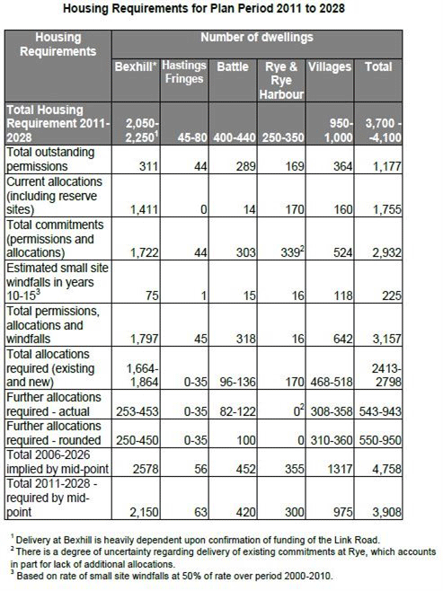
INSERTED:
Housing Requirements for Plan Period 2011 to 2028
|
|||||||||||||||||||||||||||||||||||||||||||||||||||||||||||||||||||||||||||||||||||||||||||||||||||||||||||||||||||||||||||||||||||||||||||||||||||||||||||||||||||||||||||||||||||||||||||||||||||||||||||||||||||||||||||||||||||||||||||||||||||||||||||||||||||||||||||||||||||||||||||||||||||||||||||||||||||||||||||||||||||||||||||||||||||||||||||||||||||||||||||||||||||||||||||||||||||||||||||||||||||||||||||||||||||||||||||||||||||||||||||||||||||||||||||||||||||||||||||||||||||||||||||||||||||||||||||||||||||||||||||||||||||||||||||||||||||||||||||||||||||||||||||||||||||||||||||||||||||||||||||||||||||||||||||||||||||||||||||
|
p214 |
Amend Map of Key Diagram to exclude New Railway Station at Glyne Gap
DELETED:
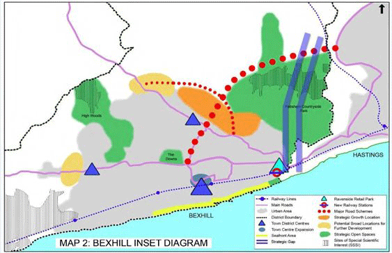
INSERTED:

|
||||||||||||||||||||||||||||||||||||||||||||||||||||||||||||||||||||||||||||||||||||||||||||||||||||||||||||||||||||||||||||||||||||||||||||||||||||||||||||||||||||||||||||||||||||||||||||||||||||||||||||||||||||||||||||||||||||||||||||||||||||||||||||||||||||||||||||||||||||||||||||||||||||||||||||||||||||||||||||||||||||||||||||||||||||||||||||||||||||||||||||||||||||||||||||||||||||||||||||||||||||||||||||||||||||||||||||||||||||||||||||||||||||||||||||||||||||||||||||||||||||||||||||||||||||||||||||||||||||||||||||||||||||||||||||||||||||||||||||||||||||||||||||||||||||||||||||||||||||||||||||||||||||||||||||||||||||||||||||
|
Sustainability Appraisal of the revised modifications |
|||||||||||||||||||||||||||||||||||||||||||||||||||||||||||||||||||||||||||||||||||||||||||||||||||||||||||||||||||||||||||||||||||||||||||||||||||||||||||||||||||||||||||||||||||||||||||||||||||||||||||||||||||||||||||||||||||||||||||||||||||||||||||||||||||||||||||||||||||||||||||||||||||||||||||||||||||||||||||||||||||||||||||||||||||||||||||||||||||||||||||||||||||||||||||||||||||||||||||||||||||||||||||||||||||||||||||||||||||||||||||||||||||||||||||||||||||||||||||||||||||||||||||||||||||||||||||||||||||||||||||||||||||||||||||||||||||||||||||||||||||||||||||||||||||||||||||||||||||||||||||||||||||||||||||||||||||||||||||||
|
MOD SA1 |
SA |
The full ‘Sustainability Appraisal of the main modifications’ www.rother.gov.uk/corestrategy If you wish to make a specific representation on the Sustainability Appraisal, to assist the Inspector in her consideration of duly-made representations, please clearly state which paragraph/table/option your representation relates to. |
|||||||||||||||||||||||||||||||||||||||||||||||||||||||||||||||||||||||||||||||||||||||||||||||||||||||||||||||||||||||||||||||||||||||||||||||||||||||||||||||||||||||||||||||||||||||||||||||||||||||||||||||||||||||||||||||||||||||||||||||||||||||||||||||||||||||||||||||||||||||||||||||||||||||||||||||||||||||||||||||||||||||||||||||||||||||||||||||||||||||||||||||||||||||||||||||||||||||||||||||||||||||||||||||||||||||||||||||||||||||||||||||||||||||||||||||||||||||||||||||||||||||||||||||||||||||||||||||||||||||||||||||||||||||||||||||||||||||||||||||||||||||||||||||||||||||||||||||||||||||||||||||||||||||||||||||||||||||||||