Core Strategy Consultation on Strategy Directions 2008
PART 1 - INTRODUCTION, CONTEXT AND VISION
(1) 1.Introduction
The Local Development Framework
1.1 The Planning and Compulsory Purchase Act requires the Council to produce a Local Development Framework (LDF) for the District. The LDF replaces the Structure Plan/ Local Plan system of plan-making.
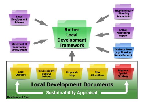
1.2 The LDF is the term used to describe the set of documents, which collectively set out how development and change across the district is to be managed. Preparation of a ‘Core Strategy’ Development Plan Document (DPD), which this consultation document is leading towards, lies at the heart of the LDF, as explained below.
1.3 Other local development documents will interpret and elaborate upon this Core Strategy. Most significant will be a separate ‘Site Allocations’ DPD, which will identify the sites required to meet the development provisions of the Core Strategy. This will also be subject to public consultation in its preparation. Supplementary Planning Documents (SPDs), which expand policies set out in DPDs, may also be prepared.
1.4 The LDF also involves preparation of “project management” documents:
- The Statement of Community Involvement
- The Local Development Scheme (The local planning authority's programme for the preparation of local development documents)
- The Annual Monitoring Report
1.5 The key documents that form part of the LDF are illustrated in the figure below.
1.6 More information about these documents can be obtained from the Council’s website www.rother.gov.uk/ldf or at its Community Help Points.
1.7 The LDF must be read in conjunction with the South East Plan and the Minerals and Waste Development Framework prepared by East Sussex County Council. Together, these will provide the statutory framework for planning in the District.
1.8 The Core Strategy and proposed Site Allocations DPD will eventually replace the current Rother District Local Plan (2006). However, the Local Plan remains the principal local planning document for development control purposes at present.
The Role of the Core Strategy
1.9 The Core Strategy has a pivotal role in delivering the objectives and local priorities set out in the ‘Sustainable Community Strategy’.
1.10 The Core Strategy is where the strategic direction for development and change is established. It sets out the Council’s vision, aims and objectives relating to the future pattern of development in the District over the period up until 2026.
1.11 It is concerned with ‘place-shaping’ and will establish how the social, economic and environmental needs of the different parts of the District can be met in the most sustainable way and in line with the policies and development requirements of the emerging South East Plan.
1.12 It must provide broad guidance on the scale and distribution of development and the provision of supporting infrastructure. It should embrace key areas of activity, such as housing, employment, transport and retailing, and draw these together in the shaping of individual places.
1.13 A key function of the Core Strategy is to provide a framework that helps to ensure that investment decisions of both public and private bodies are not made in isolation, but are properly co-ordinated and focussed towards a clear set of goals. In this respect, it will dovetail with the Council’s Corporate Plan, which sets out its contribution to achieving the Community Strategy.
Background to the Core Strategy ‘Consultation on Strategy Directions’
1.14 This ‘Strategy Directions’ document is the second stage in the preparation of the ‘Core Strategy’. It has been prepared following the consultation on the ‘Issues and Options’ between October and December 2006. The figure below shows the stages in plan preparation, and what stage we are now at. This replaces what was formerly known as the ‘Preferred Options’ stage, but remains the critical opportunity for public engagement before the final Strategy document is prepared.
1.15 There was considerable response to the Issues and Options consultation, with 500 representations, as well as 463 completed questionnaires. There were many positive and helpful comments, some very broad-ranging and requiring careful consideration in moving forward to the critical next stage. The responses also highlighted the need to undertake further evidence gathering in some areas. Summaries of individual responses are viewable on the website, while a summary of all feedback, and the Council’s consideration of that, is contained in the Interim Consultation Statement.
1.16 The aim of this second round of consultation on the Core Strategy is to give people the opportunity to comment on how the Council proposes to approach the key policy decisions to be made before the strategy is developed in detail. These are the ‘strategy directions’. In most cases, the preferred approach is indicated, although in some situations, there is no preferred option at this point.
1.17 All supporting information, including the Sustainability Appraisal Report, as well as the Interim Consultation Statement and evidence base documents, are available to download and view on the website at www.rother.gov.uk/corestrategy and at the Council’s Community Help Points.
The Next Stage
1.18 Views given on the ‘Strategy Directions’ will be considered and used to inform the final version of the Core Strategy. At that stage, there will be the opportunity to make formal representations which will be submitted to the Secretary of State.
1.19 Formal representations will be considered by an independent Planning Inspector when the Core Strategy is assessed for its soundness at a ‘public examination’. The Inspector will consider the changes suggested and produce a report with recommendations that will be binding on the Council and must be incorporated into the approved Core Strategy.
(8) 2. Spatial Portrait
Rother District
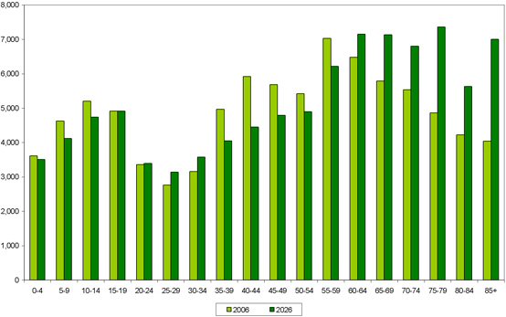
2.1 Rother district covers some 200 square miles and is a predominantly rural district. Some 88,200 people currently live in Rother (ONS, 2007), many dispersed across the rural area, but with nearly a half being in Bexhill. There are a high proportion of elderly people, especially in Bexhill, which demographic forecasts indicate will rise further. It is an attractive and safe place to live. Educational attainment is generally above the national average but below that for the South East region.
2.2 The area benefits from a blend of some of the most beautiful countryside and coastline in South East England and contains the historic market towns of Battle and Rye, the Victorian/Edwardian seaside town (and administrative centre) of Bexhill and many picturesque villages.
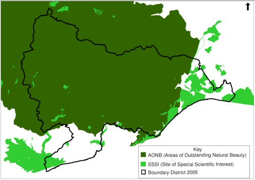
2.3 The importance of the environment is evidenced by the extent of the district designated as ‘Area of Outstanding Natural Beauty’, the large areas of national and, indeed, international nature conservation value, its number of conservation areas and the role that heritage plays in tourism.
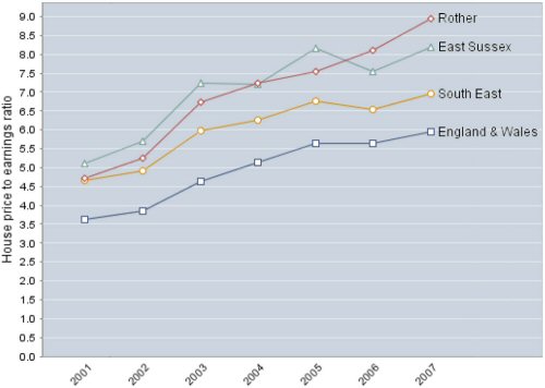
2.4 However, the economy is weak relative to the region as a whole and average local incomes correspondingly low. In part, this is a reflection of the poor economic conditions of neighbouring Hastings. Low earnings combined with the area’s high house prices result in real difficulties of housing affordability, especially for younger people. This is fuelled by the higher purchasing power of many in-comers and out-commuters.
Key Trends and Issues
2.5 Table 1 overleaf summarises the key trends and issues under five topic areas:
- population
- household characteristics
- housing affordability
- economy and employment
- socio-economic issues
- environmental assets
2.6 The “picture” presented draws on regularly collected statistical data as far as possible in order to provide a consistency and continuity of monitoring information. The main sources are: LSP Action Plans’ indicators, the LDF Annual Monitoring Report, the Council’s Performance Plan, the ‘Integrated Regional Framework’, the Audit Commission’s ‘Local Quality of Life Indicators’ and the 'East Sussex in Figures' database.
2.7 Trends in key characteristics are contained in the Annual Monitoring Report (December 2007). This document will be updated in December 2008. Details of the variations across the district is contained in ‘Rother in Profile’, published separately. Both documents are available to view online and at Community Help Points.
Table 1: Key Trends and Issues
| Topic | Key Trends / Issues |
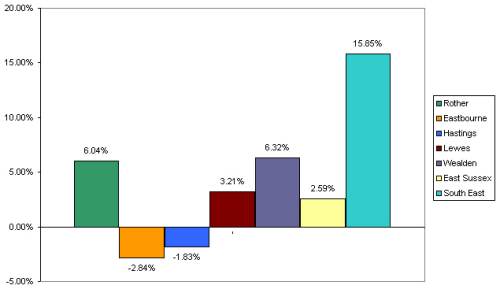
| Population | Rother’s population has grown over the 6 years between 2001 and 2007, at a similar rate to the county as a whole. Rother’s increase of 3.2% compares with the county rate of 3.1% and the rate for England and Wales of 3.3%. Between 2006 and 2016 the population in Rother is predicted to rise by 3.3% and between 2016 and 2026 by a further 2.7%. |
| Rother recorded the highest proportion of residents aged 85 and over (4.6%) of all local authorities in England and Wales in the 2001 Census. The average (mean) age of the population in the 2001 census was 46.3, higher than the average age of the population in the East Sussex (42.9) and the South East (39.1). Population density (persons per hectare) in 2001 was 1.7 in Rother, which was lower than East Sussex (2.9) and the South East (4.2). | |
| The 2001 Census revealed that, of those aged between 16 and 74 in Rother, 22.3% are retired. This is the highest proportion of all the 67 local authority areas in the South East. | |
|
Household Characteristics |
The 2001 Census reveals that 73% of all occupied household ‘spaces’ (i.e. dwellings) in Rother were occupied by one or two people. The District’s average household size is 2.17 persons. This rate is one of the lowest in the South East, ranking 64th lowest of the 67 local authorities in the region. |
| Rother’s average household income in 2007 was £31,500 which is just 84% of the average household income of the South East (£37,000). | |
| Rother has a much higher proportion of owner occupancy and a much lower proportion of social housing compared to the national, regional and county averages. In Rother, 77.9% of households are owner-occupiers and just 11.5% social rented. Equivalent figures elsewhere are as follows: England & Wales (68.9%/19.2%), South East (74%/14%) and East Sussex (75.1%/11.9%). | |
| Housing Affordability | The relative affordability of housing is a significant issue in Rother. Over the period 2000-2006, the average price of a house in the District increased at a much greater rate (81%) than the increase in average income (38%) over the same period. The ratio between lower quartile house prices and lower quartile income is now 16 in Rother – meaning a low income family needs 16 times their annual income just to buy a house. Research by the Joseph Rowntree Foundation shows that Rother is ranked in the top 30 ‘least affordable’ districts in Great Britain. |
|
Economy and Employment |
The greatest percentage of Rother’s working population is employed in the service sector (87.2%), higher than the region as a whole (85.3%). The regional importance of financial and businesses services in employment terms (23.8%) is not reflected locally (16.5%), nor is employment in transport and communications (4.6% in Rother, 6.1% in the South East). |
| Median gross weekly earnings (by place of work) in Rother at £344.5 are 28.3% lower than earnings in the South East. Unemployment in Rother in July 2008 as measured by Job Seekers Allowance (JSA) claimant rate stood at 1.7%, against the South East average of 1.4%. The claimant rate in Rother has decreased since January 2008 when it stood at 1.9%. | |
| Socio-economic Issues | According to the 2007 Indices of Multiple Deprivation, Rother has an overall rank of 163 out of the 354 English local authorities. The most deprived local authority is ranked 1, and Rother is therefore in the middle of the range. However, there has been a fall in the ranking since 2004 when Rother was ranked 181st. |
| Rother has generally low offence rates compared with East Sussex, the South East and England and Wales. Rother is currently the best performing Crime and Disorder Reduction Partnership in Sussex, exceeding the Government Office target of 15% reduction on the 2003/04 baseline by 7.6%, recording a reduction of 22.6%. | |
| Environmental Assets | Large areas of Rother are of international nature conservation importance. The Pevensey Levels is a ‘Ramsar’ site, designated for its importance as a wetland habitat. The ‘Special Protection Area’ (SPA) between Dungeness and Pett Level is important for wild birds. An area between Dungeness and Pett Level is a ‘Special Area of Conservation’ (SAC), in recognition of its flora and fauna. |
| There are 20 Sites of Special Scientific Interest (SSSI) in Rother identified by Natural England as being nationally important for their flora, fauna and geological features; these are principally located around wetland areas near the coast. A further 60 Sites of Nature Conservation Importance (SNCI) are designated as being of local biodiversity interest. | |
| Some 82% of the District falls within the High Weald Area of Outstanding Natural Beauty (AONB). | |
| There are Conservation Areas in Rother District at Battle, Bexhill Old Town, Bexhill Town Centre, Burwash, Northiam, Robertsbridge, Rye, Sedlescombe, Ticehurst and Winchelsea. | |
| There are 2,129 Listed Buildings within Rother District, as at 31st November 2007, this is based on GIS records. 31 of these are Grade 1 and 86 are Grade 2*. There are also 44 Scheduled Ancient Monuments, 7 Registered Parks and Gardens of Special Historic Interest, and 1 Registered Historic Battlefield. | |
| There is significant tree cover. Total area of ancient woodland is 7,757ha which is about 15% of the District. There are two types of ancient woodland: ‘semi natural’, which accounts for 5,311ha and ‘replanted’ which accounts for 2,246ha. | |
Future Challenges
2.8 This section investigates the interplay of trends and future challenges, or “drivers for change”. Uncertainty in such assessments must be recognised, particularly for issues at the global level, and this unpredictability inevitably increases over time.
2.9 The aim for the Core Strategy is that it remains flexible enough to manage uncertainty as well as having monitoring and review arrangements, built into it.
2.10 The pace of change is rarely even, with economic markets acting in a cyclical way and housing development often sensitive to these. While maintaining a steady rate of development is desirable in terms of a continuity of supply of accommodation, Rother faces particular difficulties in achieving this.
2.11 The economy remains relatively weak in the region and, despite regeneration efforts, could take time to improve. Also, significant growth is dependent upon new infrastructure, notably the Bexhill Hastings Link Road and, hence, is vulnerable to delays in it.
2.12 The main challenges and drivers for change that Rother will likely face over the plan period are summarised in the following table:
| Table 2: Challenges and Drivers for Change |
Population growth and migration:
|
Housing growth:
|
Local housing need:
|
Climate change agenda and use of resources:
|
Regeneration initiatives and employment
trends:
|
Infrastructure programmes:
|
Technology:
|
Changing arrangements for service delivery:
|
(6) 3. Vision of the future
3.1 Given the District’s characteristics – its strengths and weaknesses – as well as the wider challenges that it will face over the next 15-20 years, the main priorities for the future are seen as continuing to maintain the overall attractiveness of the area as a place to live and work – to provide the best possible quality of life, in both physical and emotional terms, for existing and future residents, and visitors.
3.2 Integral to this must be a greater awareness of, and a sharper response to, global warming and climate change. This adds to the need for careful management of the area’s environmental resources, including land and water. This is in line with the East Sussex Integrated Sustainable Community Strategy, as outlined in the following ‘Policy Context’ section.
3.3 The Council is also keen to ensure that development and change in Rother should recognise distinctive and diverse local characteristics. Improving the overall quality of life should promote more sustainable and healthy lifestyles.
3.4 It has to be recognised that there are both national and regional planning objectives and policies that need to be translated to the local context. The South East Plan, which will provide a statutory framework for planning at the local level, seeks to combine economic buoyancy with a more sustainable pattern of development and includes housing targets.
3.5 Increasing overall prosperity is a particular local aim. Hence, development should complement other initiatives in helping to broaden employment opportunities, improve overall skill levels and increase earning potentials. Improving connectivity between local towns and villages and with the rest of the South East will also be vital.
3.6 Encouraging and supporting younger people to remain, and work, in the area is also seen as a key part of the overall approach to improving prosperity. Utilising high quality ICT will help mitigate the area’s relative peripherality.
3.7 More widely, it will remain important to support local people, especially children and elderly as well as other vulnerable sections of our communities, to both be part of and benefit from the strong community life of the District.
3.8 Within Rother district, the towns and villages, and more countryside areas, have differing characteristics which will influence local priorities. Specific attention is given to the needs and opportunities of each of the towns – Bexhill, Battle and Rye – and of the rural areas. Development of a distinct approach for the more rural parts of the district accords with wishes expressed during consultation on issues and options.
3.9 The vision overleaf is carried forward in, and drawn from, the aims for each town and the rural areas of the district that are set out in Part II of this document, and from the “thematic” aims relating to communities, economy, environment and accessibility in Part III. It presents a description of Rother in 2026, highlighting the changes from today.
Vision
Box 1
(23) Vision for Rother in 2026 …
Rother District will be recognised for its high quality of life where there is a strong emphasis on community life. This will have been achieved by continuing to support, and further develop, vibrant, safe, balanced and inclusive communities.
Sustainable economic growth will have been secured, with much improved job opportunities, which encourages young people to stay in the area and provides greater prosperity for all.
Improved economic and social well-being will also be facilitated by better access to jobs and services for all ages, in both urban and rural areas, and improved connectivity with the rest of the region.
The area’s outstanding environmental and cultural assets will continue to be highly valued and conserved. Sensitive stewardship of environmental resources will be integral to a local commitment to a more sustainable future and a responsible, positive approach to helping address climate change issues.
Development and change will have contributed significantly to meeting local needs and aspirations. It will have responded positively to the area’s particular local circumstances and environmental resources, as well as according with the South East Plan.
Bexhill will have retained and strengthened its distinct identity and become one of the most attractive places to live on the south coast - attractive to families, the young and older people alike. As the main focus of development in the district, it will be playing its part within an integrated approach to securing a more prosperous future for the Bexhill and Hastings area.
Battle continues to be a thriving small market town and tourist centre which retains its essential character, with sensitive conservation of its historic core and setting.
Rye has improved economic and social circumstances, with a stronger and more sustainable market town role, tourism sector and Port. This will have been achieved whilst fully respecting and sensitively managing its historic character, vulnerability to flooding and ecologically important setting.
Rural areas of the district will have evolved “organically” in a manner sensitive to their essential character, diversity and relationship with their surroundings. Villages will be vibrant and inclusive, while the countryside will be economically active, accessible and well-managed.
(6) 4. Policy Context
Introduction
4.1 Rother’s planning strategy and policies need to be in line with national and regional policy unless there are reasons justifying a local exception.
National Policy
4.2 National planning policy is mainly set out in a series of Planning Policy Statements and Guidance Notes, but is also contained in circulars, ministerial statements and other strategy documents. The Planning Policy Statements generally deal with particular topics or issues. An important, overarching policy statement is PPS 1 Delivering Sustainable Development. This sets out a number of key principles for development to ensure that development plans, and decisions taken on planning applications, contribute to the delivery of sustainable development. In summary, the key principles are as follows:
- Development plans should ensure that sustainable development is pursued in an integrated manner, in line with the principles for sustainable development
- Local planning authorities should ensure that development plans contribute to global sustainability by addressing the causes and potential impacts of climate change
- A spatial planning approach should be at the heart of planning for sustainable development
- Planning policies should promote high quality inclusive design in the layout of new developments and individual buildings
- Development plans should contain clear, comprehensive and inclusive access policies – in terms of both location and external physical access
- Community involvement is an essential element in delivering sustainable development and creating sustainable and safe communities
Regional Policy
4.3 The South East Region comprises the county areas of Berkshire, Buckinghamshire, East Sussex, Hampshire, Isle of Wight, Kent, Oxfordshire, Surrey and West Sussex.
4.4 At this time, Regional Planning Guidance (RPG9) for the South East, published in 2001, is the approved regional policy for the period to 2016. The RPG supports economic development, giving encouragement to the redevelopment and recycling of urban land and the coordination of planning and transport policies, to reduce the need for travel. The advice also recognises the economic regeneration needs of the south coast towns, including Bexhill, and recommends that maximum advantage is taken of those development opportunities which are available within environmental constraints, for the recycling and redevelopment of underused and derelict land.
4.5 However, this will shortly be superseded by the South East Plan as the statutory regional framework that forms the context within which Local Development Documents and Local Transport Plans need to be prepared.
South East Plan
4.6 The South East Plan is the Regional Assembly’s term for the formal Regional Spatial Strategy for South East England. It covers the period to 2026.
4.7 It brings together policies for development with other policies and programmes that influence the nature of places and how they function, including those governing health, social issues, the economy, culture, skills and the environment.
4.8 The Plan’s vision for 2026 is for a healthier region, a more sustainable pattern of development and a dynamic and robust economy, the benefits of which are more widely shared.
4.9 The single most critical issue that has emerged throughout the Plan’s preparation is the inadequacy of infrastructure provision to keep pace with new development. The legacy of past underinvestment in the region not only has an adverse impact on the economic performance of the region, but increases environmental impacts and reduces quality of life.
4.10 The South East Plan aims to deliver an overall result of a healthier region, a more sustainable pattern of development, a dynamic and robust economy, a reduced level of social exclusion, and a more bio-diverse environment with a reduced level of natural resource consumption.
4.11 While the Regional Assembly was charged with preparing the South East Plan and its subsequent submission, it is the Government that will finally approve it. This is expected to be next Spring, following consideration of representations on its Proposed Changes to the Draft Plan.
Sub-Regional Policy
4.12 Under the Planning and Compulsory Purchase Act 2004, Structure Plans were abolished and replaced by the Regional Spatial Strategies and Local Development Frameworks. However, at present, a number of policies in the East Sussex and Brighton & Hove Structure Plan were saved by approval of the Secretary of State under paragraph 1(3) of Schedule 8 of the Planning and Compulsory Purchase Act 2004. The saved policies can be viewed at:http://www.eastsussex.gov.uk/environment/planning/development/localplanning/downloadplan.htm
4.13 While these policies provide part of the statutory planning framework, alongside the Local Plan for the time being, they will be superseded when the South East Plan is finally adopted.
South East Plan sub-regions
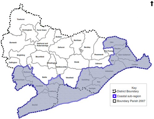
4.14 The South East Plan identifies a sub-regional strategy area called the ‘Sussex Coast Sub-Region’. This sub-regional area covers the length of the Sussex Coast from Chichester to Rye, and is home to nearly one million people. The extent of the Sussex Coast sub-region as it relates to Rother is shown on Figure 5.
4.15 As can be seen, this sub-region embraces the coastal parts of Rother, but not inland parts, including Battle. Overall South East Plan polices apply to the rest of the District.
4.16 In response to the sub-region’s extensive socio-economic difficulties, Policy CC9 of the South East Plan identifies the Sussex Coast as an area in need of extensive regeneration. This is carried forward into the specific Sussex Coast Strategy, which prioritises the social and economic regeneration of the towns in the sub-region, and this includes Rye and Bexhill.
4.17 The strategy seeks to increase the priority given to the sub-region in investment decisions of the public and private sectors. Policy SCT1 focuses on the need for a greater and more co-ordinated effort to deliver the substantial regeneration of the sub-region. It recognises that the extent of problems, as well as the scope for addressing them, is not uniform across the sub-region and highlights that locally sensitive approaches and solutions will be necessary. In fact, Hastings/Bexhill is highlighted as warranting continuing priority.
4.18 The South East Plan states that one of the only areas of strategic scope for additional greenfield development in the Sussex Coast sub-region is Bexhill. This is reflected in the housing provision for the Rother part of the Sussex Coast of 4,000 dwellings 2006-2026, equivalent to an annual average of 200 dwellings.
4.19 For Rother as a whole, the Plan requires 5,600 dwellings (280 dwellings per annum) between 2006 and 2026. This is on the basis of the inland parts of Rother accommodating 1,600 dwellings (80 dwellings per annum). It adds that all housing targets are minima.
4.20 The South East Plan states that its strategic policies and proposals, including those for the sub-regions, need to be translated into more detailed policies and action plans through local development frameworks and investment programmes detailing the delivery mechanisms. This will include identifying which agencies need to take primary responsibility for delivering (or securing the delivery of) particular aspects of policy and those that will have supporting roles.
4.21 The Core Strategy Vision has been assessed for compatibility with the ‘strategic priorities’ and corresponding Rother ‘ambitions’ of the Sustainable Community Strategy. All the nine strategic priorities are carried forward by either an aim (in the case of economy and jobs, travel choice and access, environment and climate change, and strong communities) or a component objective (in the case of education and skills, housing, health and well-being, safety, and sport/leisure/culture).
Sustainable Community Strategy
4.22 All councils have a duty to work with partner organisations to produce a Sustainable Community Strategy – a document which demonstrates how local organisations and agencies will work together to improve the economic, social and environmental well-being of their area whilst safeguarding the prospects of future generations.
4.23 The task of developing the Sustainable Community Strategy for East Sussex was undertaken by the six Local Strategic Partnerships (LSPs), namely: East Sussex, Eastbourne, Hastings and St. Leonard’s, Lewes District, Rother and Wealden.
4.24 The Sustainable Community Strategy for East Sussex 2008-2026, called ‘Pride of Place’, sets out the vision for East Sussex to 2026: to address the inequalities in the county, and create successful people, successful businesses and a sustainable environment. It is available to view at http://www.essp.org.uk/essp/esiscs.htm
4.25 Local priorities are around supporting children and young people, community safety, cultural and leisure activity, reducing environmental impacts, employment and skills, health improvement, tackling congestion, affordable housing and sustainable construction.
4.26 The Government intends that spatial planning objectives for local areas, as set out in the LDF, should be aligned not only with national and regional plans, but also with the shared local priorities set out in Sustainable Community Strategies where these are consistent with national and regional policy.
Other strategies and plans
4.27 The Rother LDF must develop within the context of national, regional and local objectives and strategic planning, transport, environmental, social and economic policies.
4.28 The LDF Sustainability Appraisal takes account of relationships between the Core Strategy and other relevant policies, plans, programmes and sustainability objectives which may influence the options to be considered in this DPD. A list of these is presented in Appendix 2 and the review of these documents and their influence on the Core Strategy can be found in the Sustainability Appraisal Scoping Report.
4.29 Of particular relevance are the existing Minerals and Waste Local Plans, prepared by East Sussex County Council, as these also form part of the statutory ‘development plan’. The County Council is also responsible for preparing a new ‘Minerals and Waste Development Framework’. This will be subject to separate consultation, but will need to be read in conjunction with the Council’s LDF.
Sustainability Appraisal and Strategic Environmental Assessment
4.30 The purpose of Sustainability Appraisal (SA) and Strategic Environmental Assessment (SEA) is to help planning authorities contribute to achieving sustainable development in preparing their plans. Sustainable Development aims to integrate the need to stimulate economic growth, to deliver the needs of all sectors of society, and to conserve and enhance the local environment. Local Planning Authority (LPA) plans must undergo a combined process of SA and SEA as a result of legislative changes enacted in the UK in summer 2004.
4.31 SEA involves examining certain plans and programmes primarily for significant environmental effects. SA widens the approach to include social and economic as well as environmental issues. The combined process reviews plans against a set of criteria reflecting local problems and the LPA’s objectives in delivering Sustainable Development and addressing these concerns.

