Schedule of Main Modifications and changes to Policies Maps
(6) Schedule of Main Modifications
|
New Mod # |
Mod Description |
Paragraph/s or Policies |
Amendment/s required |
Reason |
|
To ensure that Policy DCO1 is clear that it does not apply to shops in Town or District Centres, in accordance with other policies. |
3.3 |
Add an additional sentence at the end of the paragraph: INSERTED:The policy does not apply to shops in defined Town or District Centres as the loss of shops is resisted in these areas in line with policies BEX12, BEX13 and BEX17 of the DaSA and partly saved Policy EM13 and Inset Map 2A of the of the Rother District Council Local Plan (2006). |
Additional clarification to ensure that it is clear that there are other policies which must be considered when determining applications for loss of shops within the defined Town or District Centres. |
|
|
Policy DCO1 |
Amend the last paragraph of the policy and add footnote number to read "shops outside of defined Town or District Centres*" as opposed to "shops", i.e.: ...This includes a community facility, public house, shopINSERTED:s outside of defined Town or District Centres*, tourist accommodation or attraction..... New Footnote: INSERTED:*This policy does not apply to proposals in defined Town or District Centres as the loss of shops is resisted in these areas in accordance with Policies BEX12, BEX13 and BEX17 of the DaSA and partly saved Policy EM13 and Inset Map 2A of the Rother District Council Local Plan (2006). The insertion of this footnote will have a consequential impact on the numbering of other footnotes which will need amending. |
|||
|
MM2 |
Additional supporting text to DCO1, relating to the interaction with Core Strategy Policy CO1 (iii) (a) |
3.9 |
Add an additional sentence at the end of the paragraph: INSERTED:Proposals that accord with Core Strategy Policy CO1 (iii) (a), that is, development proposals that result in the loss of sites or premises currently or last used for community purposes, where alternative provision of the equivalent or better quality is available in the local area, or will be provided and made available prior to the commencement or redevelopment of the proposed scheme, will not be required to also meet the requirements of Policy DCO1. |
This provides clear advice that where proposals accord with Policy CO1 (iii) (a), Policy DCO1 is not invoked and further viability or marketing evidence is not therefore required. This will address any potential confusion with how Policy DCO1 relates to Core Strategy Policy CO1 (iii) (a) and what information is required to determine an application. |
|
MM3 |
Amendment to the supporting text of Policy DHG2 to provide clarity as to the locations where the policy applies. |
4.15 |
Within the first line add a footnote to 'rural areas' stating: INSERTED:*Rural areas within Rother are defined within paragraph 12.1 of the Rother Local Plan Core Strategy. |
To provide additional clarification on which areas in the District are defined as 'rural areas' and as such, where Rural Exception sites for housing could be considered. This provides clarity of the locations within the District where the policy applies. |
|
MM4 |
Additional criterion added to Policy DHG12 regarding the management of rainwater run-off. |
Policy DHG12 (iii) |
Insert an additional policy criterion after (iii): INSERTED:(iv) either, they are constructed of permeable materials, or appropriate drainage is included to manage surface water run-off in accordance with Policy DEN5. |
Rainwater run-off is covered at paragraph 4.109 of the supporting text. However, for the avoidance of doubt an additional policy criterion to manage rainwater run-off should be included. |
|
MM5 |
Amendment to criterion (ii) of Policy DEC2. |
Policy DEC2 |
Delete policy criterion (ii) (first limb) and replace with: DELETED:(ii) conserve or enhance sensitive habitats and species. INSERTED:(ii) Support the conservation of biodiversity in accordance with DaSA Policy DEN4. |
To avoid a potential contradiction with Policy DEN4. |
|
MM6 |
Rephrasing of Policy DEN3 in line with the NPPF. |
Policy DEN3 |
Amend second paragraph of the policy to read as follows: Within these Gaps, development will be carefully controlledINSERTED:.DELETED:and DevelopmentINSERTED:s will only be permitted DELETED:in exceptional circumstances. Any development must be INSERTED:where they are unobtrusive and INSERTED:do not detract from the openness of the areaINSERTED: having regard to the particular objectives of the Gaps: (i) To maintain the separate identity and distinctiveness between settlements; (ii) To maintain the strategic settlement pattern; and (iii) To prevent the coalescence of settlements. Enhancement of the Gaps through effective landscape management which strengthens and reinforces their significance as protected landscape areas will be supported. |
To rephrase the policy to be positively worded in line with the NPPF and set out what development is acceptable within the Strategic Gap. |
|
MM7 |
Amend the Figure 7 to accord with paragraph 6.21. |
Figure 7 |
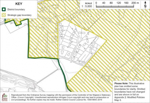
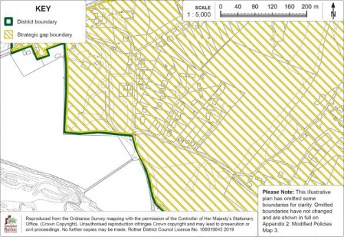
Figure 7: Strategic Gap at Fairlight should be amended to include The Close, as described in paragraph 6.21. Please see Appendix 1: Modified Detail Map 1 This also applies to Policies Map Inset Map 9: Fairlight Cove, on page 226. Please see Appendix 2: Modified Policies Map 3 for the amended Policy Map Inset Map. |
Cartographical error – To make consistent with the supporting text at paragraph 6.21 which refers to The Close being included within the Gap. |
|
(1)
MM8 |
Amendment to paragraph 6.43 to accord more closely with the PPG as to where ecological surveys and reports are required. |
6.43 |
Amend and add to the first sentence of paragraph 6.43 of the supporting text, as follows: Ecological surveys and reports will be required to be submitted with planning applications for major development DELETED:or where the development impacts on any designated site, Priority Habitat or protected species.INSERTED:; proposals which impact on a designated site or Priority Habitat; and proposals where there is a reasonable likelihood of a protected or Priority species being present and affected by the development. Assessments should be proportionate to the nature and scale of development proposed and the likely impact on biodiversity. |
To align more closely with the PPG (Paragraph: 016 Reference ID: 8-016-20140612). |
|
(1)
MM9 |
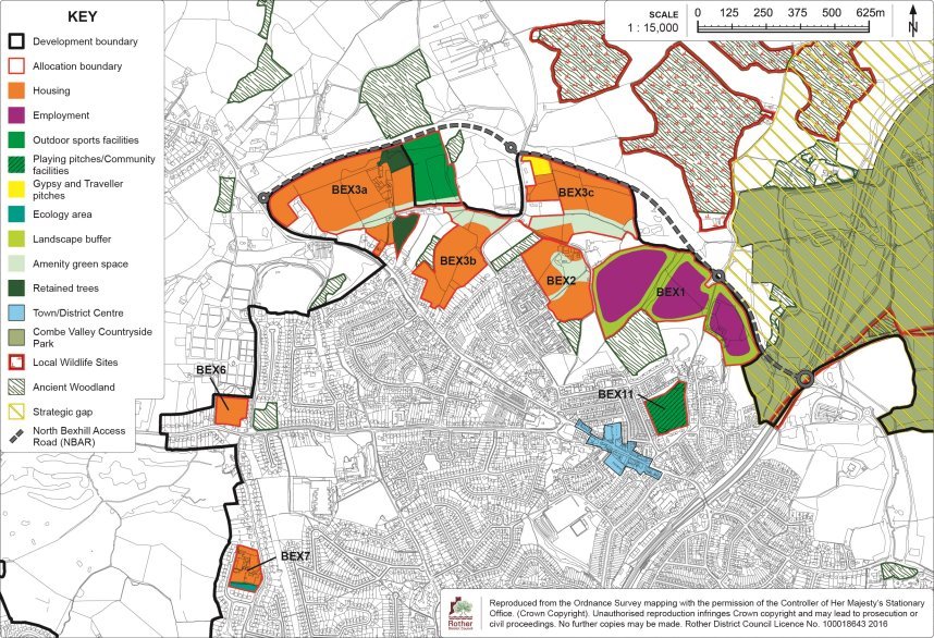
Amendment to replace the term 'playing pitches/fields', with the term 'outdoor sports facilities' in wording of Policy BEX3 and its supporting text. |
9.43 |
Delete the wording "playing field(s)" in the third line and replace with "outdoor sports facilities". |
To provide clarity on the intended use of the land for 'outdoor sports facilities' in line with the Open Space, Sport and Recreation Study which supports Policy CO3 of the Rother Local Plan Core Strategy, rather than using the terms 'playing pitches' specifically. |
|
9.46 |
Delete the wording "playing pitches," from the sixth line and replace with "outdoor sports facilities". |
|||
|
9.48 |
Delete the wording "playing fields" from the eighth line and replace with "outdoor sports facilities" |
|||
|
Policy BEX3 (vi) |
Delete the wording "playing fields" from the second line and replace with "outdoor sports facilities", i.e.: as part of (v) above, all developments will contribute to the provision of DELETED:playing fieldsINSERTED:outdoor sports facilities within site BEX3a, either directly or through proportionate (to the respective quantum of residential development) financial contributions; |
|||
|
(1)
MM10 |
Amendment to replace the term 'playing pitches/fields', with the term 'outdoor sports facilities' in wording of Policy BEX3a and its supporting text. |
Policy BEX3a |
Delete the wording "playing fields" from the second line and replace with "outdoor sports facilities", i.e.: Land with Kiteye Farm and adjoining land, as shown on the Policies Map, is allocated for housing and open space, including DELETED:playing fieldsINSERTED:outdoor sports facilities. |
To provide clarity on the intended use of the land for 'outdoor sports facilities' in line with the Open Space, Sport and Recreation Study which supports Policy CO3 of the Rother Local Plan Core Strategy, rather than using the terms 'playing pitches' specifically. |
|
Policy BEX3a (ii) |
Delete the wording "playing fields" from the first line and replace with "outdoor sports facilities", i.e.: an open space to include provision for DELETED:playing fieldsINSERTED:outdoor sports facilities of at least 2.64 hectares is set aside and laid out in the area indicated on the Detail Map; |
|||
|
Policy BEX3a (viii) |
Delete the wording "playing fields are" from the first line and replace with "outdoor sports facilities shall be", i.e.: the DELETED:playing fields areINSERTED:outdoor sports facilities shall be laid out at the same time as housing development, in accordance with a phasing plan to be agreed with the local planning authority; |
|||
|
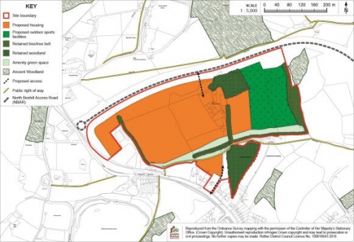
Figure 21 |
Change 'outdoor sports provision' to 'outdoor sports facilities' on the Key. Please see Appendix 1: Modified Detail Map 2 |
|||
|
Policies Map Inset Map 1b: Bexhill North |
Change 'Playing pitches' to 'outdoor sports facilities' on the Key. Please see Appendix 2: Modified Policies Map 1 for the amended Policy Map Inset Map. |
|||
|
(1)
MM11 |
Amendment to replace the term 'playing pitches/ fields', with the term 'outdoor sports facilities' in wording of Policy BEX3b. |
Policy BEX3b (ii) |
Delete the wording "playing fields" from the third line and replace with "outdoor sports facilities", i.e.: the northern part of the site towards the stream course is kept open and laid out as part of a green corridor, incorporating an enhanced footpath/cycleway, which should extend to the planned DELETED:playing fieldsINSERTED:outdoor sports facilities (see Policy BEX3a); |
To provide clarity on the intended use of the land for 'outdoor sports facilities' in line with the Open Space, Sport and Recreation Study which supports Policy CO3 of the Rother Local Plan Core Strategy, rather than using the terms 'playing pitches' specifically. |
|
MM12 |
Amendment to the text of criterion (iii) (b) of Policy BEX3b so that requirements for traffic management are consistent between sites for BEX3b and BEX3c. |
Policy BEX3b (iii)(b) |
Amend Policy BEX3b (iii)(b) to clarify: (iii) access is from Watermill Lane, the details of which will be subject to a findings of a Transport Assessment, with the expectation that: (a) A single access will be provided where appropriate sight lines can be achieved; (b) DELETED:Provision is made for a new footway/cyclewayINSERTED:Traffic management measures are introduced on Watermill Lane to calm traffic, with specific regard to the short section north of Mayo Lane and to ensure the safe movement of pedestrians and cyclists between the site and Sidley in association with the provision of a new footway/cycleway along most of the length of the Lane from the Mayo Lane junction to the stream (to dovetail with requirements under Policy BEX3c); |
The requirements for traffic management relate specifically to both sites BEX3b and BEX3c. The amendment sets out this consistency between sites BEX3b and BEX3c. |
|
(1)
MM13 |
Additional requirement in Policy BEX4 to upgrade the local sewerage system prior to occupation of the new development. |
9.60 |
Insert new paragraph after 9.60 (and subsequent consequential paragraph number amendments): INSERTED:Additional reinforcement of the sewerage network will be required to serve the development and therefore, the developer will need to work with Southern Water to ensure necessary infrastructure is provided prior to occupation. |
To acknowledge that wastewater capacity is limited and highlight the requirement to work with the service provider to upgrade the existing infrastructure. |
|
Policy BEX4 |
Additional policy criteria inserted between (ii) and (iii) of policy BEX4 (and subsequent consequential criteria number amendments): INSERTED:(iii) provision is made for an acceptable connection to the local sewerage system, in agreement with the service provider; |
|||
|
(2)
MM14 |
To include the requirement for an Appropriate Assessment at planning application stage. |
Policy BEX6 |
Additional wording to part (v) of the policy: (v) at least two forms of appropriate 'Sustainable Drainage' are incorporated in accordance with Policy DEN5 'Sustainable Drainage' INSERTED:and an Appropriate Assessment under the Habitats Regulations demonstrates beyond reasonable scientific doubt that these can be delivered on the site without harming the integrity of the Pevensey Levels Special Area of Conservation/Ramsar site. |
To demonstrate beyond reasonable scientific doubt that proposals can be delivered without harming the integrity of the Pevensey Levels should be applied to this site which would be consistent with Policy BEX9 and BEX10. |
|
(2)
MM15 |
To include the policy requirement for two stages of SuDS and an Appropriate Assessment at planning application stage. |
9.81 |
Add the following to the end of the supporting text at paragraph 9.81: INSERTED:In accordance with Habitats Regulation Assessment (HRA) work undertaken to inform the Core Strategy and DaSA, a minimum of two types/ stages of Sustainable Drainage (SuDS) treatment will be required to address the possible negative effects from surface run-off and hydrological pathways on the water quality in the Levels, in accordance with DaSA Policy DEN5. It will be necessary for any planning application for the site's development to be accompanied by a site specific Appropriate Assessment to ensure that the required SuDS mitigation can be achieved and any adverse impact on the integrity of the Levels can be avoided. |
The policy already sets out the requirement for at least two stages of appropriate SuDS, which reflects the outcome of the HRA. Notwithstanding this, in light of the recent "People Over Wind" judgement and in the interests of ensuring consistency with other DaSA allocation policies, it is agreed that it is appropriate for this issue and requirement to be identified. This was identified in the Council's Initial Responses to Representations (6 Mar 2019) (Reference: RDC-DaSA-004) but had not been explicitly set out in the Schedule of Proposed Modifications (6 Mar 2019) (Reference: RDC-DaSA-005). This proposed modification corrects that error. |
|
Policy BEX7 (vii) |
Amend policy criterion (vii) to read: (vii) in accordance with Policy DEN5 'Sustainable Drainage', at least two forms of appropriate SuDS are incorporated INSERTED:and an Appropriate Assessment under the Habitats Regulations demonstrates beyond reasonable scientific doubt that these can be delivered on the site and that the development can otherwise proceed, with mitigation if necessary, without harming the integrity of the Pevensey Levels Special Area of Conservation/ Ramsar site. |
|||
|
MM16 |
Additional requirement to policy and supporting text to require a Travel Plan intended to promote the use of cycling, walking and other sustainable transport modes in compliance with Core Strategy Policy TR3 and the NPPF. |
9.122 |
Amend paragraph 9.122 as follows: 9.122 INSERTED:Notwithstanding that the site is served by the existing bus service in close proximity to the site, development should take advantage of alternative travel choices to the private car, including off-site measures to promote cycling and walking and other sustainable transport modes recognised by the NPPF, that provide efficient, safe and accessible means of transport with overall low impact on the environment, including electric, low and ultra-low emission vehicles, car sharing and public transport. The original public footpath which crossed the site before the development of the site as a prison should be reinstated to give enhanced access to the countryside and the Levels to the north. This would provide an alternative to the poorly used path 59a. This would also provide better access to footpath 12b which links Coneyburrow Lane to Little Common. |
Policy and supporting text to be amended to require a Travel Plan intended to promote the use of cycling, walking and other sustainable transport modes in compliance with Core Strategy Policy TR3 and the Framework. |
|
Policy BEX10 (vii) |
Amend criteria (vii) as follows: (vii) DELETED:iINSERTED:a travel plan is included to promote the use of alternative travel choices other than the private car, including off-site measures to support cycling and walking and other sustainable transport modes to encourage the use of public transport, car sharing and electric, low and ultra-low emission vehicles in compliance with Core Strategy Policy TR3. Improvements INSERTED:should also beDELETED:are made to existing local bus stop infrastructure and a financial contribution towards improving local bus services INSERTED:is provided; |
|||
|
(1)
MM17 |
Amendment to the wording of the policy and supporting text to reflect that there are two culverts running through the site. |
9.162 |
Proposed change:
|
Text amended to the wording of the policy and supporting text to reflect that there are two culverts running through the site. |
|
Policy BEX14 (xi) |
Amend criteria (xi): (xi) an 8 metre built development exclusion zone from INSERTED:either side of the main river culvertINSERTED:s which passDELETED:es through the site, is achieved to allow access to the existing outfall; |
|||
|
MM18 |
Amendment to the wording of policy BEX17 and supporting text replacing 'should be resisted' with 'not be supported', in relation to the further concentration of takeaway uses. |
9.187 |
Amend paragraph 9.187 to give clarity on the approach to any further concentration of takeaway uses in Sidley District Centre. 9.187 Given the high concentration of takeaways (defined as Use Class A5 in the Use Classes Order) in Sidley District Centre and the known deprivation issues in the locality, it is considered that the further concentration of takeaways DELETED:should be resistedINSERTED:will not be supported. |
To make it clear that further takeaway uses in Sidley District Centre will not be supported. |
|
Policy BEX17 |
Amend the final paragraph in the Policy to give clarity on the approach to any further concentration of takeaway uses in Sidley District Centre. Within Sidley District Centre, further concentration of takeaway uses (within Use Class A5) will DELETED:be resistedINSERTED:not be supported. |
|||
|
(2)
MM19 |
Additional text in policy HAS2 and its supporting text that requires proposals do not impact water quality in the adjacent Park Wood gills. |
10.22 |
Proposed additional clarification text at paragraph 10.22: The site is adjacent to the High Weald Area of Outstanding Natural Beauty (AONB). Residential dwellings to the north are few and set within large plots, thereby representing low density development and maintaining a rural context. Any development would need to be mindful of the AONB countryside to the north and appropriate landscape buffers would need to be incorporated within any potential scheme to respect wider views from the north. INSERTED:There are watercourses which flow north into gills within Park Wood which are vulnerable to changes in water quality. Any impact on the gills will need to be considered within site design. Care should also be taken to respect the relationship with residential properties on the periphery of the site. |
To ensure that the policy and its supporting text reflects the issue of maintaining water quality in gills by requiring that surface water drainage matters are addressed in any planning application and that any impacts are properly assessed. |
|
Policy HAS2 (v) |
Proposed amendment of policy criteria (v): (v) provision is made for an acceptable connection to the local sewerage system in agreement with the service provider INSERTED:and surface water drainage proposals do not adversely impact on the watercourses which feed into Park Wood. |
|||
|
MM20 |
Additional text in policy HAS3 and its supporting text to clarify that the proposed allocation is within the High Weald AONB. A presentational error is also corrected. |
10.28 |
Proposed change to insert a clarification within the first sentence of paragraph 10.28 to indicate that the site is located within the High Weald AONB: This north-east sloping and undulating area of vacant scrubland is located adjacent to the existing well-established and fully occupied Ivyhouse Lane industrial estate located within Hastings borough INSERTED:and is in the High Weald AONB. The existing industrial estate INSERTED:to the south presents a very "raw" edge to the openness of the adjacent High Weald AONB beyond. |
To clarify that the proposed allocation is located within the High Weald AONB, as consistent with Policy DEN2, and presentational error in the policy. |
|
Policy HAS3 (iii) & (iv) |
Amend policy criteria (iii) & (iv): (iii) access is provided off Ivyhouse Lane in Hastings Borough; (iv) development does not intrude into views from the INSERTED:wider Area of Outstanding Natural Beauty to the northDELETED:; and DELETED:(iv) provision is made for enhanced landscape planting, as indicated on the Detail Map, as part of INSERTED:theDELETED:wider landscape management of this part of the DELETED:wider valley, including new and enhanced green infrastructure of the north of the employment site; |
|||
|
(1)
MM21 |
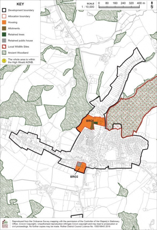
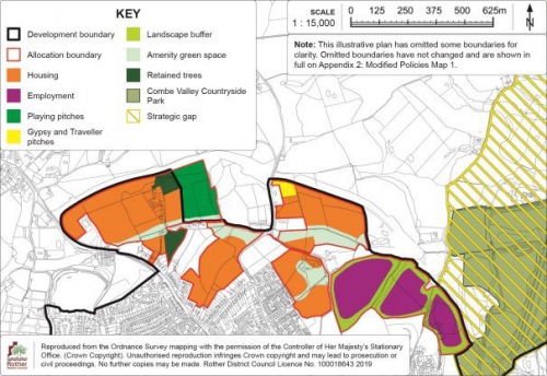
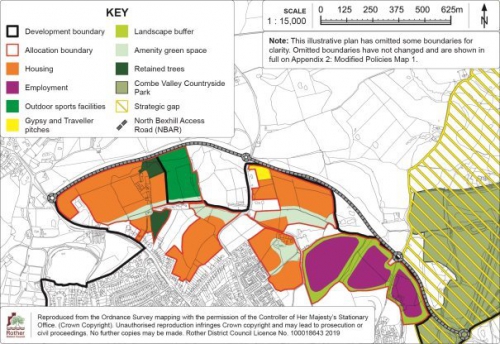
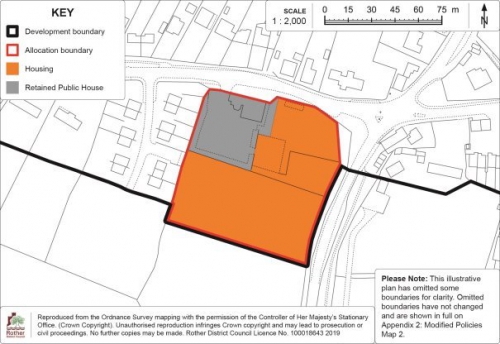
Amend Policy BRO2, its supporting text and the Detail Map regarding sewerage capacity arrangements and amendment to the site boundary to reflect a recent planning application delegated to approve. |
11.45 |
Insert wording at the beginning of paragraph 11.45: INSERTED:Additional reinforcement of the sewerage network will be required to service the development and therefore, the developer will need to work with Southern Water to ensure necessary infrastructure is provided prior to occupation. |
Additional wording required in light of the revised capacity assessment undertaken by Southern Water, and to accord with drawing no. 1802-P-204_B, submitted pursuant to planning application RR/2018/1813/P which was approved on 12 February 2019. |
|
Policy BRO2 (v) |
Insert an additional policy criterion after (v): INSERTED:(vi) provision is made for an acceptable connection to the local sewerage system, in agreement with the service provider. |
|||
|
Figure 45: Policy BRO2 Detail Map |
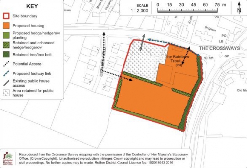
Policy BRO2: Land at the Rainbow Trout public house: It is necessary to make a slight amendment to the extent of the proposed housing area shown on the Detail Map to accord with the details of the planning application (reference RR/2018/1813/P) which was delegated to approve, subject to the completion of a Section 106 Legal Agreement, on 12th February 2019. Amend the western boundary of the northern section of the housing area (shown in orange) on Figure 45 (Policy BRO2 Detail Map) by a marginal amount to accord with drawing no. 1802-P-204_B, submitted pursuant to planning application RR/2018/1813/P. Please see Appendix 1: Modified Detail Map 3 Policies Map Inset Map 6: Broad Oak has also been updated in this regard. Please see Appendix 2: Modified Policies Map 2 for the amended Policy Map Inset Map. |
|||
|
(1)
MM22 |
Amendment to the wording of Policy CAM1 to ensure that development has no adverse effect on the integrity of the adjacent Natura 2000 Sites. |
11.67 |
Amend paragraph 11.67 to read: In view of the proximity of the site to the international wildlife designations and the potential for additional DELETED:recreational impacts, the development should DELETED:contribute to achieving the SARMS strategy, which may also include financial contributionsINSERTED:ensure that there is no adverse effect on the integrity of the SPA/ Ramsar site, with mitigation if necessary, in line with the provisions of the SARMS. |
To ensure that development has no adverse effect on the integrity of the adjacent Natura 2000 Sites. |
|
Policy CAM1 (vii) |
Replace criterion (vii) of Policy CAM1 with: (vii) DELETED:the development contributes towards the implementation of the Dungeness Complex Sustainable Access and Recreation Management Strategy (SARMS).INSERTED:the development has no adverse effect on the integrity of the adjacent Natura 2000 Sites and supports the implementation of the Sustainable Access and Recreation Management Strategy (SARMS) as appropriate. |
|||
|
(1)
MM23 |
Amendment to the wording of Policy CAM2 and its supporting text to ensure that development has no adverse effect on the integrity of the adjacent Natura 2000 Sites. |
11.75 |
Replace the last sentence of paragraph 11.75 with: DELETED:In view of the proximity of the site to the international wildlife designations and the potential for additional recreational impacts, the development should contribute to achieving the SARMS strategy, which may also include financial contributions.INSERTED:In view of the proximity of the site to the international wildlife designations and the potential for additional recreational impacts, the development should ensure that there is no adverse effect on the integrity of the SPA/ Ramsar site, with mitigation if necessary, in line with the provisions of the SARMS. |
To ensure that development has no adverse effect on the integrity of the adjacent Natura 2000 Sites. |
|
Policy CAM2 (vi) |
Amend criterion (vi) of Policy CAM2 to read: (vi) DELETED:the development contributes towards the implementation of the Dungeness Complex Sustainable Access and Recreation Management Strategy (SARMS).INSERTED:the development has no adverse effect on the integrity of the adjacent Natura 2000 Sites and supports the implementation of the Sustainable Access and Recreation Management Strategy (SARMS) as appropriate. |
|||
|
MM24 |
Amendment to supporting text to Policy CAT1, detailing the requirement for a project level HRA to be provided, in order to demonstrate that proposals will not adversely affect the Pevensey Levels SAC. |
11.99 |
Amendment to end of paragraph 11.99: A sewer line crosses the eastern part of the site and this will also need to be considered in planning a development layout.INSERTED: Drainage would need to be considered in accordance with Policy DEN5, and although the site's development is unlikely to have any adverse effect on the integrity of the Pevensey Levels Special Area of Conservation (SAC)/Ramsar site, this would need to be confirmed through a project-level Habitats Regulation Assessment (HRA). |
Natural England has advised that at planning application stage, a project level HRA would be necessary to demonstrate that development would not have an adverse effect on integrity of the Pevensey Levels SAC. As such, the amendment is to ensure that drainage forms part of the consideration for any relevant planning application and that evidence is provided that demonstrates that the integrity of the SAC will not be adversely affected by the development. This is in accordance with Policy DEN5. |
|
(1)
MM25 |
Amendment to the wording of Policy FAC2 and its supporting text to ensure clarity regarding what is required in terms of the provision of a serviced plot for a doctors surgery as part of any proposed scheme. |
11.120 |
Add the following text to the end of paragraph 11.120: INSERTED:In the event that a scheme comes forward that does not include a serviced plot for a doctor's surgery, any planning application will need to be accompanied by comprehensive evidence, which is supported by the Clinical Commissioning Group, demonstrating that it is not required in the area. |
To provide clarity that a serviced plot for a new doctor's surgery is required to be provided rather than the doctor's surgery itself; and to ensure that if a scheme comes forward without a serviced plot for a doctors surgery, that this is supported by comprehensive evidence that it is not required. |
|
FAC2 (iii) |
Amend policy criteria (iii) as follows: (iii) INSERTED:a serviced plot for a new doctor's surgery DELETED:is provided, together with INSERTED:space for associated car parking INSERTED:is provided, subject to business case support from the Clinical Commissioning Group; |
|||
|
(1)
MM26 |
Amendment to Detail Map supporting Policy FAC2 and the Policies Map to move the boundary of the proposed access. |
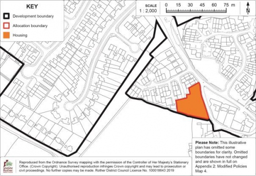
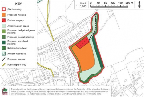
Figure 50: Policy FAC2 Detail Map |
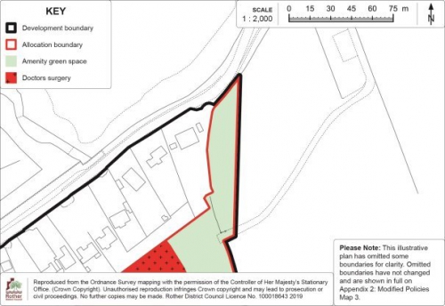
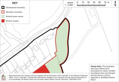
It is necessary to increase the size of the site to include a greater amount of land along the proposed access. Move the boundary to the east of the proposed access approximately 10m further east. Policies Map Inset Map 9: Fairlight Cove has also been updated in this regard. Please see Appendix 1: Modified Detail Map 4 |
To ensure that the site access is of an adequate size to accommodate a sufficient alignment together with acceptable visibility splays. |
|
Policies Map Inset Map 9: Fairlight Cove |
In line with the modification to Figure 50: Policy FAC2 Detail Map (above), it is necessary to increase the size of the site area for FAC2 to include a greater amount of land along the proposed access. Move the boundary to the east of the proposed access approximately 10m further east and move the development boundary to be in line with this. Figure 50: Policy FAC2 Detail Map has also been updated in this regard. Please see Appendix 2: Modified Policies Map 3 for the amended Policy Map Inset Map. |
|||
|
(1)
MM27 |
Additional criterion added to Policy RHA1 and its supporting text regarding on the adjacent Natura 2000 Sites. |
11.197 |
Add a new sentence after the second sentence of paragraph 11.197 to read: INSERTED:In view of the proximity of the site to the international wildlife designations and the potential for additional impacts, the development should ensure that there is no adverse effect on the integrity of the SPA/ Ramsar site, with mitigation if necessary, in line with the provisions of the SARMS, referred to in Policy DEN4. |
It is accepted that the site is in close proximity to the Natura 2000 Sites and may have a direct impact in terms of run-off and infiltration, access and other activity; (it has found not to be functionally-linked land) Hence, they can legitimately be expected to be compatible with, and potentially contribute to, ensuring that the integrity of the designations are maintained. The amendment accords with the proposed addition of criterion (vii) to Policy RHA1. (see below) |
|
11.200 |
Add a new sentence to the end of paragraph 11.200 to read: INSERTED:An appropriate foul and surface water drainage scheme should include surface water protection measures and, where practicable, elements of SuDS in accordance with Policy DEN5 and taking due account of the high water table and risk of contamination. |
For consistency with other site allocation policies in the vicinity of the Dungeness Complex, a separate policy criterion will be added to cover all impacts on the integrity of the Natura 2000 Sites (and have regard to the SARMS identified in Policy DEN4), together with additional text relating to potential SuDS. The amendment accords with the proposed addition of criterion (vii) to Policy RHA1. (see below) |
||
|
Policy RHA1 |
Add a new criterion (vii) to Policy RHA1 to read: INSERTED:(vii) the development has no adverse effect on the integrity of the adjacent Natura 2000 Sites and supports the implementation of the Sustainable Access and Recreation Management Strategy (SARMS) as appropriate. |
To ensure that development has no adverse impact on the adjacent Natura 2000 Sites and supports the implementation of SARMS, in line with Policy DEN4. |
||
|
(1)
MM28 |
Additional criterion added to Policy RHA2 regarding on the adjacent Natura 2000 Sites, with additional supporting text. |
11.205 |
Add a new paragraph after paragraph 11.205 (and make consequential paragraph number amendments) to read: INSERTED:11.205a In view of the proximity of the Employment Area to the international wildlife designations and the potential for additional impacts, the development should ensure that there is no adverse effect on the integrity of the SPA/ Ramsar site, with mitigation if necessary, in line with the provisions of the SARMS, referred to in Policy DEN4. |
To ensure that development has no adverse impact on the adjacent Natura 2000 Sites and supports the implementation of SARMS, in line with Policy DEN4. The amendment accords with the proposed addition amendment of criterion (iv) to Policy RHA2. (see below). |
|
11.205 |
Add a new paragraph after paragraph 11.205a (see above) to read: INSERTED:11.205b Development will also need to include provision for appropriate foul and surface water drainage, having regard to sewer provision and existing levels of contamination. The scheme should include elements of SuDS where practicable, although these will need to be carefully designed having regard to the high water table and risk of underlying contamination. |
An additional criterion should be added to require an appropriate drainage scheme, in order to address the comments of the Environment Agency. The amendment accords with the proposed addition of criterion (vii) to Policy RHA2. (see below) |
||
|
Policy RHA2 (iv) |
Replace criterion (iv) with: (iv) DELETED: there is no adverse impact on the adjacent Dungeness, Romney Marsh and Rye Bay SSSI, SPA and Ramsar Site or on the Rye Harbour SSSIINSERTED:the development has no adverse effect on the integrity of the adjacent Natura 2000 Sites and supports the implementation of the Sustainable Access and Recreation Management Strategy (SARMS) as appropriate; |
To ensure that development has no adverse impact on the adjacent Natura 2000 Sites and supports the implementation of SARMS, in line with Policy DEN4. |
||
|
(1)
MM29 |
An additional criterion is added to require an appropriate drainage scheme with any submitted planning application. |
Policy RHA2 (vi) |
Add an additional policy criterion after (vi) as follows: INSERTED:(vii) an appropriate foul and surface water drainage scheme is provided, in accordance with Policy DEN5. |
An additional criterion is added to require an appropriate drainage scheme, in order to address the comments of the Environment Agency. |
|
MM30 |
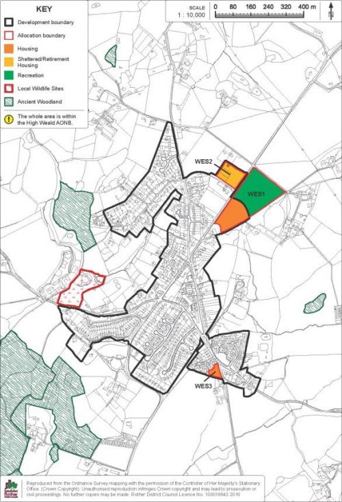
Deletion of Policy WES4 and consequential changes. |
Page 7 |
Delete the reference to Policy WES4 from the list of Site Allocation Policies on page 7 of the DaSA Proposed Submission. DELETED:Policy WES4: Land between Moor Lane and the A28, Westfield |
Policy WES4 deleted as the land owner has indicated that the land is no longer available for the use proposed. |
|
Page 10 |
Delete the reference to Figure 60 from the list of Figures on page 10 of the DaSA Proposed Submission. DELETED:Figure 60: Policy WES4 Detail Map |
|||
|
Page 258 |
Delete the title "Site Allocation: Land between Moor Lane and the A28, Westfield" on page 258 of the DaSA Proposed Submission. DELETED:Site Allocation: Land between Moor Lane and the A28, Westfield |
|||
|
11.236-11.239 |
Delete paragraphs 11.236 to 11.239 inclusive and amend the numbering of subsequent paragraphs accordingly. DELETED:11.236 This is a narrow strip of undeveloped land that was set aside by the County Council for the construction of a bypass, but plans for that were abandoned a number of years ago and the land has remained vacant. It was proposed to become a footpath/cycleway in the 2006 Local Plan, also linking to the Goulds Drive development, but this is not now readily achievable. 11.237 Consequently, there is the opportunity to allocate the land for an alternative use for allotments, of which there is a recognised shortfall in the village. Pedestrian access would be from Moor Lane, and a crossing point should be provided. Limited parking provision to serve the allotments would also be required, which could be accommodated at the northern end of the site or take the form of a small layby on Moor Lane, which the Highway Authority has indicated would be acceptable in principle. 11.238 A small area at the northern end of the currently vacant area is excluded from the allocation, but included within the development boundary and could potentially accommodate 1 or 2 dwellings fronting Moor Lane. 11.239 The Detail Map below provides an indicative general layout of the development site in accordance with the above policy. |
|||
|
Policy WES4 |
Delete Policy WES4 (yellow box) on page 259. DELETED:Policy WES4: Land between Moor Lane and the A28, Westfield Land between Moor Lane and the A28, as shown on the Policies Map, is allocated for allotments. Proposals will be permitted where: (i) Allotments are provided in the area indicated on the Detail Map; (ii) Pedestrian access to the allotments is provided from Moor Lane; and (iii) Off-road vehicle parking provision for users of the allotments is achieved and a pedestrian crossing point on Moor Lane is provided, to the satisfaction of the Highway Authority. |
|||
|
Figure 60: Policy WES4 Detail Map |
Delete Figure 60: Policy WES4 Detail Map |
|||
|
Policies Map Inset Map 14: Westfield |
Amend Policies Map Inset Map 14: Westfield (page 260) to delete the text and image indicating Policy WES4 and also the "Allotments" notation in the Key.
|
|||
|
MM31 |
Appendix 1 amended to include a list of Core Strategy policies which have been superseded by their respective DaSA policies. |
Table of Contents |
In 'Table of Contents', under Appendix 1 add: INSERTED:Superseded Core Strategy Policies |
To ensure that it is clear which DaSA policies
supersede the Core Strategy policies. See below. |
|
1.4 |
Add the following text at the end of paragraph 1.4: INSERTED:There are also a small number of Core Strategy policies that are superseded by policies within the DaSA which are listed in Appendix 1. |
To ensure that the introduction is clear as to which policies provide the basis for determining planning applications and where policies have been superseded. |
||
|
Appendix 1 |
Add the following text after policy SRM1: INSERTED:(parts (ii) - (viii) inclusive) |
To provide clarification that part (i) of Policy SRM1 has been superseded by DaSA Policy DRM3 insofar as it updates the thresholds regarding energy efficiency consideration as part of the planning application process. |
||
|
Delete the following policies from the list of Core Strategy Policies: DELETED:LHN2 (Affordable Housing) DELETED:LHN3 (Rural Exception Sites) DELETED:EC3 (Existing Employment Sites) |
These policies have been superseded by the respective DaSA policies and should therefore be deleted. |
|||
|
Add new title after 'IM3 Phasing of Development' to say: INSERTED:Superseded Core Strategy Policies Add new text under 'Superseded Core Strategy Policies': INSERTED:SRM1 (i) (Towards a Low Carbon Future) LHN2 (Affordable Housing) LHN3 (Rural Exception Sites) EC3 (Existing Employment Sites) |
To provide separate list of superseded Core Strategy policies for clarity. |
|||
|
(2)
MM32 |
Appendix 2 amended to include list of superseded Neighbourhood Plan policies. |
Appendix 2 |
Amend Appendix 2 title: Superseded Local Plan 2006 DELETED:policiesINSERTED:and Neighbourhood Plan policies Add new text after 15.10 to say: INSERTED:Superseded Neighbourhood Plan policies Ticehurst Neighbourhood Plan Policy H4 Affordable Housing (part (i) only) Salehurst and Robertsbridge Neighbourhood Plan Policy EC3 Employment Retention (part (ii) only) |
Additional clarification is necessary to indicate which Neighbourhood Plan policies would be superseded by DaSA relevant policies. |
Schedule of changes to Policies Maps
|
Policies Map Mod # |
Page |
Policies Map # |
Amendment required |
Reason |
|
PMM1 |
172 |
Policies Map Inset Map 1b: Bexhill North |
Amend Policies Map Inset Map 1b: Bexhill North to include NBAR. Please see Appendix 2: Modified Policies Map 1 for the amended Policy Map Inset Map. |
Cartographical update: The map should include NBAR for completeness. The new road is complete and has now opened. |
|
PMM2 |
172 |
Policies Map Inset Map 1b: Bexhill North |
Change 'Playing pitches' to 'outdoor sports facilities' on the Key.
|
To provide clarity on the intended use of the land for 'outdoor sports facilities' in line with the Open Space, Sport and Recreation Study which supports Policy CO3 of the Rother Local Plan Core Strategy, rather than using the terms 'playing pitches' specifically. |
|
PMM3 |
203 |
Policies Map Inset Map 6:Broad Oak |
Amend Policies Map Inset Map 6: Broad Oak to reflect
the amendments made to Figure 45 (Policy BRO2 Detail
Map) which moves the western boundary of the northern
section of the housing area (shown in orange) on
Figure 45 by a marginal amount to accord with drawing
no. 1802-P-204_B, submitted pursuant to planning
application RR/2018/1813/P. |
To accord with the additional wording required to Policy BRO2 in light of the revised capacity assessment undertaken by Southern Water, and to accord with drawing no. 1802-P-204_B, submitted pursuant to planning application RR/2018/1813/P which was approved on 12 February 2019. |
|
PMM4 |
226 |
Policies Map Inset Map 9: Fairlight Cove |
Amend Policies Map Inset Map 9 to reflect the amendment made to Figure 7: Strategic Gap at Fairlight to include The Close, as described in paragraph 6.21. Please see Appendix 2: Modified Policies Map 3 for the amended Policy Map Inset Map. |
Cartographical error – To make consistent with the supporting text at paragraph 6.21 which refers to The Close being included within the Gap. |
|
(1)
PMM5 |
226 |
Policies Map Inset Map 9: Fairlight Cove |
In line with the modification to Figure 50: Policy FAC2 Detail Map, modify Policies Map Inset Map 9 so that the size of the site area for FAC2 includes a greater amount of land along the proposed access. Move the boundary to the east of the proposed access approximately 10m further east and move the development boundary to be in line with this. Please see Appendix 2: Modified Policies Map 3 for the amended Policy Map Inset Map. |
To ensure that the site access is of an adequate size to accommodate a sufficient alignment together with acceptable visibility splays. |
|
PMM6 |
260 |
Policies Map Inset Map 14: Westfield |
Amend Policies Map Inset Map 14: Westfield (page 260) to delete the text and image indicating Policy WES4 and also the "Allotments" notation in the Key.
|
Policy WES4 deleted as the land owner has indicated that the land is no longer available for the use proposed. |
Appendix 1: Modified Detail Maps
|
Modified Detail Map 1 | Figure 7: Strategic Gap at Fairlight [MM7] |
Modified Detail Map 2 | Figure 21: BEX3a Detail Map [MM10] |
|
|
|
|
Modified Detail Map 3 | Figure 45: Policy BRO2 Detail Map [MM21] |
Modified Detail Map 4 | Figure 50: Policy FAC2 Detail Map [MM26] |
|
|
|
Appendix 2: Modified Policies Maps
Modified Policies Map 1 | Policies Map Inset Map 1b: Bexhill North [MM10] [PMM1] [PMM2]
See Appendix 3: Figures 1a & 1b for comparison between the submitted and modified maps (with and without NBAR).
Modified Policies Map 2 | Policies Map Inset Map 6: Broad Oak [MM21] [PMM3]
See Appendix 3: Figures 2a & 2b for comparison between the
submitted and modified BRO2 housing and retained public
house areas.
Modified Policies Map 3 | Policies Map Inset Map 9: Fairlight Cove [MM7] [PMM4] [PMM5]

See Appendix 3: Figures 3a & 3b for comparison between the submitted and modified Strategic Gap boundary.
See Appendix 3: Figures 4a & 4b for comparison between the submitted and modified FAC2 allocation boundary and Fairlight development boundary.
Modified Policies Map 4 | Policies Map Inset Map 14: Westfield [MM30] [PMM6]
See Appendix 3: Figures 5a & 5b for comparison between the
submitted and modified maps (with and without Policy
WES4).
Appendix 3: Illustrative changes to Policies Maps
|
Figure 1a | Illustrative plan showing submitted Inset Map without NBAR |
Figure 1b | Illustrative plan showing submitted Inset Map with NBAR [MM10] [PMM1] [PMM2] |
|
|
|
|
Figure 2a | Illustrative plan showing submitted BRO2 housing and retained public house areas |
Figure 2b | Illustrative plan showing modified BRO2 housing and retained public house areas [MM21] [PMM3] |
|
|
|
|
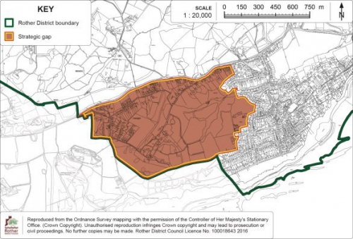
Figure 3a | Illustrative plan showing submitted Fairlight strategic gap boundary |
Figure 3b | Illustrative plan showing modified Fairlight strategic gap boundary [MM7] [PMM4] |
|
|
|
|
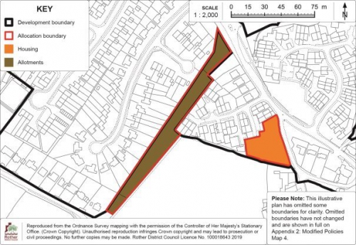
Figure 4a | Illustrative plan showing submitted FAC2 allocation and Fairlight development boundary |
Figure 4b | Illustrative plan showing modified FAC2 allocation and Fairlight development boundary [MM26] [PMM5] |
|
|
|

|
Figure 5a | Illustrative plan showing Policy WES4 as submitted |
Figure 5b | Illustrative plan showing Policy WES4 deleted [MM30] [PMM6] |
|
|
|